Latest News Archive 2007
 Radioactivity MA Marine Aggregates ML Marine Legislation BW Bathing Water MR Marine Reserves RE Renewable Energy OA Ocean Acidification PO Pollution FI Fisheries GW Global Warming CE Coastal Erosion
December 2007
RE UK announces huge expansion in offshore wind electricity generation
MR Greenpeace calls for new action to save North Sea cod via Marine Reserves
GW Arctic ice hits new record summer low
CE Why are our Beaches eroding? - Coastal Zone '07 paper
CE Insurers call for 25-year flood management strategy
GW Auk Deaths in the North Sea
CE Councillors fear of 'No recovery'
MR 'Nature's banks' pays dividends
CE Iron Ships and Sandless Shorelines
CE Threat to our water supplies
CE The threats to our vulnerable coastal ecosystem
November 2007
MR MARINET helps clean up Pegwell Bay
CE New Consideration on Erosion - at last!
GW Wildlife hit by the recent North Sea Surge
CE Southwold may put flood defence cost on Council Tax
CE Sea inundations threat to main A12 road
CE Facing the decisions - rebuild, retreat of defend?
GW Melting Ice and Rising Seas
CE More on DEFRA's Shoreline (mis)Management Plan
CE Report on the November 2007 North Sea Surge
MR Can The Crown Estate prevent damage to Lyme Bay's reefs and marine life?
MR Does the public have an unfettered right to fish at sea?
CE Sea wall repairs are 'sticking plaster'
GW Claim that shipping pollution is "far more damaging than flying"
CE Norfolk Green Party severely criticise Norfolk's coastal defence policies
ML Draft UK Marine Bill in Queen's Speech
PO Able UK seeks permission for expansion of its dry dock at Hartlepool
CE Ongoing controversy over the SMP
GW Our warming seas - a 'bad sign for our coastal waters'
CE Loss of Sea Defences likely at Clacton and Holland-on-Sea
MR Devon Wildlife Trust campaigns to "Save Lyme Bay"
October 2007
CE National Audit Office's response to MARINET's concerns with SMP
CE The impending loss of Great Yarmouth Beach
MA BBC respond to MARINET's criticism of Coast item on Hallsands, Devon
ML Marine NGOs produce a response to the White Paper on a UK Marine Bill
PO Use of the North Sea as a nuclear dump?
MA National Marine Aggregate Dredging Statistics for 2006
CE Further environmental problems resulting from DEFRA's SMP
GW UEA scientists report shock climb in CO2
CE Seeing is believing - the erosion at Felixstowe
ML Britain Waives the Rules - our treatment of our sea
CE Sea Defence abandonment looms nearer
CE Threat to our best countryside
ML Pressure for a Marine Bill builds up
ML Nationwide Petition for a Marine Act
FI EU Report says 80% of fish stocks are over-fished
CE More villages sacrificed to demands of the SMP
CE Suffolk coastal villagers react angrily to SMP
BW English Heritage Survey shows Peoples value of our coast
RE Wildlife Trust on Marine Reserves
CE Government relaxes on SMP insistence
MA Aggregate dredging may be threatening Sizewell nuclear power station
RE Lyme Bay conservation status damaged by scallop dredgers
RE FOE Cymru says No to Severn Barrage
RE UK Sustainable Development Commission reports on Tidal Power
RE Tidal turbine for Strangford Lough is "on the way"
RE UK takes a lead on offshore wind
RE Cornish Wave Hub secures RDA funding
CE Fighting for their shoreline
CE More losses threatened by SMP
CE Council sets conditions for Shoreline Management Plan compliance
MA New Research - but is it independent?
CE Lowestoft MP takes up the cudgels on Coastal Erosion
FI Danger of discarded fishing nets highlighted
September 2007
CE Coastal campaigner's court victory
RE Scientist hails Firth potential in tidal energy
RE The Sustainable Development Commission will report on tidal power this autumn
MA Welsh dredging decision comes under fresh attack
CE Too much of coast sacrificed - letter in the EDP
PO Plastic waste a serious threat to marine wildlife
CE Council's dealing with DEFRA's demands
CE MARINET members warn Great Yarmouth Council not to accept the current Shoreline Management Plan
ML Britain's damaged Seas and the need for the Marine Bill
August 2007
CE Recycled Glass bottles for saving our beaches
MA MARINET asks Government about appeal procedures over aggregate licence for Area 401/2
CE Unusual winds and groyne problems for cliff man
PO Sewage set for sea near Lowestoft
RE Tidal Power for the UK - the Severn estuary debate
CE Conservatives work to preserve Walney coast
MA Plaid Cymru opposes Gower dredging
MA Sea defences are not enough
GW Dimethyl Sulphide's rôle in climate regulation is confirmed
PO Worldwide Ban on TBT finally agreed
MA Beach worries over dredging
CE MARINET member argues strongly for Great Yarmouth to reject local Shoreline Management Plan
CE Study hope for coastal homes at risk
PO Petition set up to object to oil being transferred between tankers in the Firth of Forth
ML MARINET member criticises Eastern Daily Press journalist for lack of research on UK Marine Bill
MA More on Gower Dredging go-ahead
CE Strengthened coastal flood and erosion rôle for Environment Agency
CE Cash-strap problems threatens Walney Sea Defences
GW Research centres join forces for Scottish Oceans Institute
CE Retreat from Managed Retreat?
MA Assessing the risks posed by marine aggregate extraction
July 2007
CE £8m coastal defence scheme finished
CE USA Awareness of our predicament
CE Change of Heart on Coastal Protection?
GW Audit Office asks whether Wales is ready for rising seas
CE English Heritage predicts loss of historic sites due to erosion
FI New research reveals the secret life of lobsters
PO Public Inquiry to hear case against the breakage of the US Navy "ghost ships" at Hartlepool
MA Government approves new aggregate dredging sites in Eastern English Channel
MA Crown Estate leads Severn Estuary aggregate dredging inquiry
June 2007
CE Beach recharge at Newbiggin Bay
PO Seaside peril at Hunstanton, Norfolk
PO Sewage pollution at Hendon, Tyne and Wear
CE Beach recharge at Bournemouth goes seriously wrong
GW Surfers foresee surfing threat from Global Warming
FI Fisheries impacting adversely on dolphins off Devon and Cornwall
PO EU report says Europe's seas are being "ruined"
PO Coal Authority to pump minewater into sea
MA Downing Street petition calls for cessation of marine aggregate dredging
MA Is Aggregate Dredging affecting the Severn Estuary?
MA Dredging fears along vanishing coastline - Dredging Area 102
FI UK marine life in crisis, wildlife charity warns
ML Serious weaknesses in UK Marine Bill White Paper
ML UK Government's proposals for a Marine Bill
May 2007
CE £35 million sea defence approval
CE Likely nuclear sites need flood defences
PO Environmental groups protest at sewage plant
MA Great Yarmouth Fisherman's Revelations
RE Earthwatch Lecture: Managing the Marine Environment
PO Letter of objection concerning the article below
PO Lowestoft Sewage Treatment Works to temporarily pump raw sewage to sea
CE Fears over Lowestoft seafront erosion
CE Huts tower over Felixstowe's beach
RE Offshore wind - two new major projects in the Thames Estuary
RE FOE Cymru says no to Severn Barrage
April 2007
ML The UK Government issues a White Paper for its proposed Marine Bill
MA Aggregate dredging site, Area 436, left in poor condition
MA UK Government issues temporary aggregate dredging licences for Area 401/2
MA New aggregate dredging licence application for Area 430 offshore from Sizewell, Suffolk
FI EU Commission announces new policy on fishing by-catches
BW How Safe are our Seaside Bathing Waters?
March 2007
RE Marine Reserves meet with success in New Zealand
MA Dutch Dredging Profits, UK Losses
MA Operators Commended in Marine Archaeological Awards
PO Erosion and Flooding threat to Nuclear Reactors
RE Conservation sites to become Marine Reserves
PO Sizewell nuclear plant could be flooded
RE Wave energy showing potential
CE More homes at risk as coastline slips into sea
February 2007
PO Port of Tyne : offshore dumping of contaminated dock sediments.
RE Worlds biggest wave energy farm for Orkney
CE Erosion and Beach Recharge at Dorset
RE Technological Advance in Generating Electricity from Tides
MA MMS involved in dredge plume research
CE Increasing East Anglian Coastal Damage
CE Fears over crumbling sea wall
CE Protect us - plea to Government
CE Flood work hit by cash delays
GW Warmer UK seas could mean more jellyfish but less fish
MA Beach Recharge - is this policy destroying our beaches and wasting our money?
January 2007
PO MSC Napoli shipwreck - Information for Media - 25th January 2007
CE Artificial Reefs Scoping Study by CIRIA
CE Villagers asked to dig deep to protect homes
MA Welsh beaches are being ruined by dredging
MA Area 401/2, Great Yarmouth : Government prevaricates over licence decision.
PO MSC Napoli shipwreck - Information for Media - 22nd January 2007
PO Port of Tyne - Poison in the Water
UK announces huge expansion in offshore wind electricity generation
The UK Government (Department for Business, Enterprise and Regulatory Reform) announced on 10th December 2007 that it is launching a Strategic Environmental Assessment for a "third round" of off shore windfarms to be built by 2020 which, if constructed, could generate enough electricity to power all of the UK's 25 million homes. This will involve the generation of 33GW (gigawatts) of offshore wind energy. The 'first round' of offshore wind farms, in 2001, comprised a number of small demonstration projects. The 'second round', in 2003, resulted in the award of options for leases for larger scale projects in three designated areas - the Thames Estuary, the Greater Wash and the North West. Based on current plans under the first and second leasing rounds, about 8GW of capacity could be operational by around 2014. This includes the 1GW London Array which is the largest planned offshore wind farm in the world. The proposal for a possible 'third round', and further regular rounds, of offshore wind development announced by the UK Government would open up the vast bulk of the UK's continental shelf to large scale development. It would allow for up to a further 25GW of offshore capacity on top of the planned 8GW. In total this is sufficient to generate enough power for up to 25 million homes by 2020.
Full details can be seen on the Government News Network website.
Five Round 1 projects (Scroby Sands, North Hoyle, Kentish Flats, Barrow, and Burbo Bank), as well as the demonstration turbines at Beatrice Oil Platform and Blyth, are now operational, totalling 404MW. A further six Round 1 projects are under construction, collectively almost 583MW. In the last 12 months, BERR has consented a further 2.5GW of offshore wind projects. The Crown Estate intends to announce the competitive process and commercial terms for Round 3 offshore wind farm lease options in early 2008.

Greenpeace calls for new action to save North Sea cod via Marine Reserves
Greenpeace is asking people to email the UK Environment Minister, Hilary Benn, to express their concern at the UK and EU decision to continue to allow cod stocks to be fished in the North Sea and to ask the Minister to recognise that, if we are to have any chance of saving the commercial cod fishery in the North Sea, we must act now to create Marine Reserves in the North Sea specifically aimed at protecting cod and other commercially fished species. For further details, see the Greenpeace statement below, along with a Greenpeace website address for further advice on how to contact the Minister.
Greenpeace Statement:
"As you know North Sea cod stocks have been in a perilous state since the mid 1980s, collapsing from around 300,000 tonnes to a low of around 70,000 tonnes in 2000. ICES, the scientific body which advises EU governments on quotas, recommends that a cod stock of less than 150,000 tonnes in the North Sea is unsustainable. That's why they've recommended a zero quota for the past seven years. Our governments have repeatedly refused to act on this advice and have continually set quotas of over 20,000 tonnes per year for North Sea cod during this period.
"The situation is made worse by high-levels of discards or 'bycatch', where ships fishing for other species such as prawns or haddock also catch cod. As the cod are not part of that vessel's quota, or because they have already exceeded their quota, they can't be landed and have to be thrown back into the sea, dead or dying. EU fisheries commissioner Joe Borg has admitted that between 40-60 per cent of all the cod caught in the North Sea fall into this category, and described this unbelievably wasteful situation as "immoral".
Now, for the first time in years, ICES has reported that cod stocks are beginning to show signs of recovery. But their recommendation for next year is still to reduce the amount of fish caught to half of what was landed in 2006. The UK government is inexplicably using this new advice and the discard problem as the basis to call for increased fishing quotas - in effect dealing with a chronic shortage of fish by allowing even more to be taken. Work that one out! They are doing exactly the opposite of what the science dictates, to appease the fishermen who see the slight resurgence in cod stocks as proof that the days of abundance are here again - which they almost certainly are not.
This week's announcement just shows how short-sighted and narrow-minded Fisheries Ministers are. They've repeatedly failed our ocean environment, and failed to protect the species and ultimately the livelihoods they sustain. It's time that our Environment Ministers stepped in to protect our seas.
Fishermen themselves admit that they cannot control what they catch - using selective gear which minimises bycatch is almost impossible, as is targeting specific species of a certain size. The only solution which has a chance of working over the longer-term is establishing marine reserves - national parks at sea where all extractive industries, including fishing, would be prohibited. By closing off large areas where there are spawning stocks or juvenile communities of cod we can give them a chance to recover, and guarantee a sustainable future for our fishing communities at the same time.
What you can do
It's taken a while, but the message is starting to get through to mainstream opinion formers that we have to act now to have any chance of saving cod and other North Sea fish stocks. If you haven't already, please take this opportunity to send a message to the UK Minister, Hilary Benn, saying that the North Sea needs Marine reserves and needs them now".
Arctic ice hits new record summer low
The Arctic ice cap shrank to a new record low of 4.13m square kilometres this summer, US research institute NSIDC (National Snow and Ice Data Centre) has reported. The ice minimum, which appears to have been reached on 16 September, was 22 per cent below the last record set in 2005.
The low this year was nearly 39 per cent below the long-term average. Compared with this average, the area lost this year - at 2.6m km² - is equivalent to 60 per cent of the entire land area of the 27 EU countries.

The figure shows the position clearly. On the right is the sea ice extent on September 9, 2007, one of the lowest days of the melt season. On the left is the September sea ice extent in 1979. The comparison between September 1979 and September 2007 reveals the historic decline in summer sea ice extent.
Note: The Northwest Passage was closed in September 1979 but is now open in September 2007. The Northeast Passage (the Northern Sea Route) along the coast of Siberia, is still closed in September 2007 by a narrow band of sea ice.
Data derived from Sea Ice Index data set: National Snow and Ice Data Centre.
For additional information visit the United States NSIDC website.
Why are our Beaches eroding? - Coastal Zone '07 paper
'Coastal Zone 07' was held at Portland, Oregon, from July 22nd to July 26th 2007 to discuss a wide range of coastal concerns. 920 delegates representing 16 countries attended. One session was devoted to the topic 'Why are our beaches eroding?' As this is very pertinent to our campaign, with the permission of Professor Vincent May, we have reproduced it in full here - www.marinet.org.uk/mad/coastalzone07.html
Insurers call for 25-year flood management strategy
The Association of British Insurers, hard hit by the floods over this past year, are calling on the Government to provide a twenty-five year flood managing strategy. The details of this were placed as a Press Release on Tuesday 4th December '07, on the ABI website.
Public backs overhaul of drainage as top priority and expect floods to return
The ABI (Association of British Insurers) today called on the Government to develop a 25-year strategy to manage Britain's growing flood risk. The recommendation comes in the ABI's report, Summer Floods 2007: Learning the Lessons. The ABI wants to see a 25-year national flood strategy, based on:
- An investment programme that reflects climate change and the real flood risks from rivers, coasts and drainage.
- Improved national leadership and coordination with national targets for reducing flood risk. A single national body should be responsible for flood management strategy to replace the current piecemeal approach.
- Stronger planning controls to ensure that new developments are not built in high flood-risk areas wherever possible.
Stephen Haddrill, Director General of the ABI, said:
"This summer's devastating floods highlight the urgent need for a long-term strategy based around more investment, national coordination and better land use planning. Insurers want to continue to provide flood insurance. The right decisions from the Government will ensure that flood insurance remains widely available and affordable in the UK."
The ABI is also publishing today the results of an exclusive opinion survey by Populus in the areas affected by the summer flooding (Yorkshire and Humberside, Gloucestershire and Worcestershire).
- Residents of the flooded areas say that an overhaul of drainage systems is the most urgent measure now needed to reduce the risk of future flooding.
- Nearly two thirds (61%) think it likely that their areas will be affected by flooding again on the same scale as this summer.
- Residents have a positive view of the response of their local authority and insurance company to the floods. Asked to rate a number of bodies on a scale of 1-5 (where 1 means a very bad job and 5 means a very good job), residents rated their local authority 3.28, their insurance company 3.26, the Environment Agency 3.13 and national government 2.64.
- Disruption of travel was the major impact of the floods, with 67% of residents saying they were affected. Others were power cuts (26%), disruption to water supplies (22%) and the closure of places of work (21%). 15% of residents report that their property sustained flood damage.
Auk Deaths in the North Sea
In October, wildlife photographer Jenny Sharman of Winterton-on-Sea contacted Pat Gowen to alert MARINET & the NSAG, along with the RSPB and RSPCA, to vast numbers of sea birds, mainly Guillemots, that she found washed up along the north-east Norfolk Coast. There were few Razorbills, very few Puffins and no Gulls whatsoever.
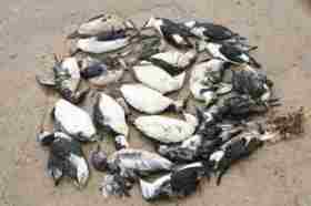
A cluster of dead Guillemots found by the tideline at Winterton, found and photographed by Jenny Sharman
Investigation showed that the to the untrained eye the birds at first appeared quite fat and with no external signs of poisoning. Fisherman member Richard Docwra reported that he had found "thousands and thousands out to sea". Although lesser events like this have occurred before, they usually came about later in the year.
The RSPB considered the cause of the holocaust to be due to starvation, and that the thick plumage of the birds hid the emaciation of their bodies. So is this due to sand-eel shortage? And is this due to factory harvesting sand-eels for use as fertilizer, to our warming seas, or due to other reasons? The following 7th December '07 Telegraph article by Brian Unwin points a few fingers.
Call for research after mass bird deaths
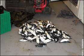
Dead birds that were found on the Scandinavian coast
Thousands of British seabirds have washed up dead on shorelines sparking calls for more international research into problems that could lead to future population crashes.
The discovery of thousands of dead and dying auks, mainly razorbills, around the coasts of Denmark, southern Norway and Sweden, in September and October, didn't arouse widespread UK attention because there was comparatively little evidence of problems on this side of the North Sea. But alarm bells rang after the latest British Trust for Ornithology BirdTrack Update referred to "a large wreck of auks seen along the north and east coasts, and as far afield as the Oslo fjord ... All of these appear to have starved - and most were adults."
This disaster was of UK significance because, after the breeding season's end, Scotland's razorbills head for Scandinavian waters. This was underlined by numbered rings on several corpses: one started life on the Shiant isles off Lewis in the Outer Hebrides in 1982; another on the Isle of May off Fife on the mainland's east coast in 2000.
What caused particular concern, however, was that the birds were in an emaciated state - indicating failure to catch sufficient small fish to fuel their life on the open sea - and almost all were adults. Normally such disasters are associated with protracted severe weather in deep mid-winter; to have happened in the autumn suggested most exceptional circumstances.
Kjell Isaksen, the Oslo municipality's biologist and wildlife manager, said "massive" number of dead and dying razorbills were washed ashore in his area. "Razorbills and guillemots were also seen on lakes far inland or found grounded on fields." He had examined externally 60 per cent of 500 dead razorbills picked up locally and noted they were "only skin and bone", so emaciated he was surprised that birds originating in Scotland had been able to reach Norway. The conclusion in every case was "death by starvation." "It seems clear that the massive movement must have been initiated by large scale food shortage in the area were these birds stayed - probably the North Sea or West Skagerrak. The fact that they turned up along our coasts was probably more or less a coincidence due to the prevailing wind direction."
Dr Tycho Anker-Nilssen, a Norwegian Institute for Nature Research senior research scientist, who will examine 400 of the corpses, said establishing their origin would be a top priority. An unknown number - possibly thousands - may have died at sea and vanished without trace.
RSPB Orkney officer Eric Meek commented: "There is absolutely nothing here to indicate that this is anything other than a food shortage-related incident. All the birds we have handled have been very thin and they are dying in the classic way in starvation incidents."
A few weeks after razorbills washed ashore at Orkney, dead puffins started appearing also. "This was interesting because puffins usually disperse out to sea and head in a generally southerly direction." As with the razorbills in Norway, measurements of 50 puffin corpses found at Scapa Flow produced surprises. "Many of the adults were in complete moult - and therefore flightless - which was about three months out of sync with what is known of puffin moult. It seems to suggest these birds were under some particular form of stress."
Martin Heubeck, an Aberdeen University seabird specialist was alerted to the razorbill "wreck" in southern Scandinavia by a contact in Sweden who told of "extraordinary numbers" arriving there. He stressed this disaster showed the need for the organisation of co-ordinated surveys of coastlines on both British and European sides of the North Sea each autumn to monitor what happens to auks dispersing from their breeding colonies - "something I've been recommending for 20 years."
However, the RSPB, which organises a national beached birds survey every February, is reluctant to expand this. Spokesman Grahame Madge said: "Finding enough volunteers to turn out in February is hard enough - organising such an operation at other times of year as well would be even more difficult. A better policy would be increased research into why certain seabird species are failing to find food."
Norway's Dr Anker-Nilssen commented: "A lot of work remains before we understand in more detail the mechanisms behind these worrying problems for seabirds in the North Sea and west Nordic waters in general. So the challenge for marine scientists in general, including seabird ecologists, is huge. I am, however, much more optimistic these days than only a few years ago that we will get there eventually - hopefully in time to avoid that we contribute to 'irreversible' processes that reduce the great value and importance of these environments."
Councillors fear of 'No recovery'
Written by John Howard in the East Anglian Daily times of 5th December 2007 comes this news showing the concern of Suffolk Coastal Councillors should the Environment Agency's Plan be put into practice.
Lose coast forever if lose defences
A leading councillor is warning that Suffolk may never recover from abandoning coastal defences.
County councillors, whose cabinet met at Ipswich yesterday, are set to fight the Environment Agency over plans to abandon flood defences in Suffolk's estuaries.
The agency claims it must save money in sparsely populated rural areas in order to help fully fund schemes to protect urban populations.
But Suffolk County Council fears that a "no active intervention" strategy proposed for the Blyth Estuary will, if finally approved, also be introduced for the Alde and Deben estuaries, leaving farmland and isolated homes more vulnerable to flooding.
It is thought to be the first time in the UK that the cash-strapped Environment Agency has proposed abandoning the maintenance of established defences and some councillors believes it could be a test case for abandoning others.
Guy McGregor, a cabinet member, said: "We do not want to hold the sea back at all costs, but we should not go to the other extreme and say we will do nothing and we are all doomed. Once you start to give up your defence of the coast it is gone and gone for ever and the reality is that you will never recover from that."
Councillor Rosemary Clarke said: "We are at enormous risk. This part of the world is known as the heritage coast. At the moment, the way we are going, there will not be much to inherit, it will drop into the sea."
The county council is particularly worried about increased frequency of flooding on the A12 at Blythburgh as well as the increased risks faced by 170 residents living on low-lying land in the estuary's flood plain.
The authority also fears that the area could also become less attractive to visitors with the loss of amenities, including the viability of Southwold Harbour, flooding of the Southwold Caravan Park, loss of important footpaths and consequential loss to businesses reliant on visitors.
The report suggests the proposed policy of "no active intervention" in maintaining flood defences will have serious consequences for the character and economy of the Blyth Valley.
But the agency said that officials had to follow Government guidelines in prioritising flood defence spending in the long-term public interest.
Dr Charles Beardall, the agency's area manager, said: "It seems that councillors are asking to hold the line all round and that is just not practical, feasible or affordable. We have to cut our cloth according to the money we are given and protect the public as best we can."
The organisation said that prioritising guidelines meant that spending money to maintain defences in the Blyth estuary could not be justified, leading to the proposal to withdraw the maintenance of some sea walls, and re-focus the money on higher priority areas.
'Nature's banks' pays dividends
Marine reserves, co-managed by local communities, can help alleviate the impact of poverty, a study suggests.
Research into four successful schemes showed that getting villagers involved in protection projects reduced harmful overfishing and protected incomes.
Average incomes of people who had established no-fish zones were more than double those who did not have protected areas, the authors found.
The full article can be read on the BBC website of the 30th November '07. Alternatively the full report produced by Nature Conservancy, a US group, can be viewed as a large pdf file here.
Iron Ships and Sandless Shorelines
Jerry Berne kindly retailed to us information supplied to him by Dick Holmberg that he discovered in an 1863 textbook which stated how the shorelines in the US were then expanding, and indeed had been expanding for an indefinite period. Dick has long said that other textbooks prior to the 1900's state similar observations. Now coastlines, not only in the US but all around the world are in a state of collapse. For sure, for the past many decades the majority coastline of East Anglia was accreting and did not start to seriously disappear until after marine dredging commenced. The question arises 'What happened?'
In addition to the obvious gravitational slide of coastal material resulting from a steepened shoreline and a dredging deepened seabed, coupled with the reductions and changes of offshore sandbanks, there is another damaging impact.
Dick seems to correctly surmise that it was the advent of the iron ships which sparked the need to dredge deeper navigational channels, which technology later led to offshore aggregate dredging. The dredgers jettison the sediments which reaches and leaches the shore of the littoral systems. Offshore sandbars and reefs became perforated with these channels, removing these shore protective and important habitats. So it all commenced when we engineered our coastal rivers and inlets so that ships no longer needed to sail on the tide, making great profits for many folks, but incurring a massive environmental debt which continues to grow. We are even yet to paying the interest on it.
The engineering of our coastlines continues to favour the profits over the prophets. What many might be led to think by clever marketing is payment on this debt. Mining the offshore for beach nourishment actually increases the damage and only hastens the collapse of our coastal environmental systems.
Jerry believes that Dick is successful because he seems to be one of the few (with almost none of the usual "experts" included --especially today's coastal engineers and geologists) who truly sees the historic and full cause and effect elements of our coastal crisis. His concepts of recreating structures which mimic the functioning of deltas and other energy decreasing natural formations is so elegant in its simplicity and so effective in its implementation that it almost seems too easy. Of course, given the myriad forces at work, it actually is not that easy requiring a thorough analysis of each individual site and designing for it a unique system to properly reduce those forces at the right points.
It is frustrating to know that we have had concepts such as Holmberg's available for decades, yet are not acting on these or any other methods that might have some chance of success, choosing to continue those methods known to fail and increase the damage. Just think how fully employing Holmberg techniques over just the last decade might have led to further advances in his and other like scientists abilities to pay down this debt while once again having our shorelines expand.
The pages quoted come from the textbook 'Text-book of Geology - designed for Schools and Academies' by James D. Dana, LL.D, Hilliman Professor of Geology and Natural History in Yale College, author of 'A manual of Geology', 'A system of Mineralogy's and reports.
Threat to our water supplies
From Jerry Berne of 'Sustainable Coastlines', our counterpart in the USA on Coastal Erosion, comes these thoughts on the threat to our water supplies. He writes:
One of the great problems now facing us is the dimishing supply of potable (fresh) water. The sea rise of some 3.2 mm per annum and the land sink of East Anglia and Kent of 2 mm per year coupled with the loss of our coastlines to what is now mostly manmade erosion is hurrying the loss of coastal fresh water resources. Unfortunately for our world's population, most of us seem to live along our coastlines. The infiltration and intrusion of salt water into coastal aquifers, the forcing of salt water far inland through deeply dredged canals and the loss of land protecting these water resources through ill-conceived policies and practices threaten our very lives, not just those of the flora and fauna life being drowned in this salt water.
The hazard is partcularly acute in East Anglia, where much of the coastline and the sea defences will be abandoned to the sea if DEFRA's myopic policies are allowed to come into being. Not only will much valuable agricultural land be lost, this at a time of future threatened droughts and increasing demand, but irrigation supplies will become salinated. The valuable eco-system of the Norfolk and Suffolk broads will be lost also.
The short-term economics of the current governments policy will create a huge loss to future generations unless sanity prevails.
The threats to our vulnerable coastal ecosystem
From 'ScienceDaily' of October 21st, 2007, comes the latest findings of the BBVA Foundation's Third Debate on Conservation Biology showing the serious loss of biodiversity of our coastal ecosystems. The debate was organized jointly by the BBVA Foundation and the Cap Salines Coastal Research Station (Imedea-CSIC and University of the Balearic Islands).
Coastal Habitats Are The Biosphere's Most Imperiled Ecosystems
The BBVA Foundation's Third Debate on Conservation Biology allowed leading international experts to present findings of their latest research into the scale, causes and consequences of global loss of coastal habitats. The disappearance of these ecosystems, which include coral reefs, mangrove forests, wetlands and seagrass meadows, has serious consequences like loss of biodiversity, depletion of exploitable living resources, impaired capacity of the oceans to sequester CO2 and loss of the leisure value of the coastal zone. Not only that, the coastline becomes more vulnerable to the increased erosion associated with rising sea levels.
Carlos Duarte, researcher at the Spanish Council for Scientific Research and coordinator of the debate, informed the public that "coastal habitats are disappearing at a rate of between 1.2% and 9% a year and are now the biosphere's most imperiled systems, with rates of loss 4 to 10 ten times faster than those of the tropical rainforest."
The causes of these losses are many and include "the rapidly growing population of coastal zones, currently home to 60% of the planet's inhabitants, along with the urban development, infrastructure works and ecosystem destruction this growth entails." Also, increased discharges of nitrogen, phosphorus and organic matter have caused the deterioration of waters and sediments in many of the world's coastal zones.
Duarte added that climate change is aggravating the impact of human activity on coastal habitats: "Global warming and the resulting rise in sea level are driving the loss and degradation of coastal habitats, reducing the effectiveness of conservation programs and causing an environmental problem of global dimensions which will also have a large economic impact on coastal societies."
Lack of oxygen is causing catastrophic mortality among marine organisms. Increased loadings of nitrogen and phosphorus due to coastal urbanization and the use of agricultural fertilizers are eroding the environmental quality of all coastal ecosystems, with tropical systems especially affected.
Scott Nixon (University of Rhode Island, USA) explained that this process, known as eutrophication, is not a recent phenomenon, but one that first appeared with the spread of urban sewage networks in the second half of the nineteenth century and has been accelerating sharply since 1970. According to Nixon, "we are seeing a clear global increase in the incidence of hypoxia in coastal ecosystems," a phenomenon whereby the oxygen concentration in water drops so far that it causes catastrophic mortality among marine organisms. Prof. Nixon went on to add that "there is a relationship between the health damage done by the excessive consumption of meat in developed societies and the health damage done to coastal ecosystems by the massive nitrogen emissions associated with meat production."
Mediterranean warming: A threat to Posidonia meadows
Núria Marbà, a researcher at the Mediterranean Institute for Advanced Studies (Imedea) talked about the results of the Praderas project, funded by the BBVA Foundation, which show that most Mediterranean meadows of Posidonia oceanica - extremely valuable ecosystems for the functions and services they provide - have experienced severe shrinkage in the last 40 years. "We have observed a rise in mortality among some marine angiosperm species in the aftermath of heat waves, suggesting that meadow decline will accelerate as the seawaters continue to warm."
Studies carried out as part of this project, she explained, show that the seagrass meadows along the Spanish coast are losing about 5% of their extension each year, and even more in years like 2003 when the sea temperature rises higher than normal.
Bill Dennison, of the University of Maryland Centre for Environmental Science (USA), clarified that "seagrass meadows are vital habitats which grow along the coasts at tropical and temperate latitudes and supply ecological services that make them among the most valuable ecosystems in the biosphere". It is estimated that 54% of meadows have lost part of their coverage.
Dennison contends that seagrass meadows reflect changes in ecosystem quality and act as global biological barometers for man-made pollution; the meadows are like "coal mine canaries" for the health of coastal ecosystems and their decline is an unequivocal sign of coastal environmental stress.
According to Dennison, "reports on changes in seagrass meadow extension have documented losses since 1980 of an area equivalent to two football fields with each hour that passes. Most worrying of all is that these calculations are very much on the conservative side, since only 9% of seagrass meadows have been studied. So the total area lost probably equates to 10 football fields per hour."
One of the factors favoring this loss is that seagrass meadows are not in the public eye, despite their ecological importance: "In the case of coral reefs, around 130 news items appear in the mass media for every scientific article published, compared to just 13 items appearing for every scientific article on seagrass meadows. It is vital that we bridge this gap between science and social awareness" added Dennison, before concluding his intervention with a call for "a global conservation effort to halt the loss of seagrass meadows."
Fish contribute to the recovery of coral reefs
"The combined effects of overfishing, pollution and global change have caused serious harm to coral reefs, which are increasingly being taken over by algae," alerts Terry Hughes, director of the Australian Research Council Centre for Coral Reef Studies.
Recent data suggest that 44% of the planet's coral reefs have been destroyed or are about to disappear. In Hughes' view, it is already too late to stop global warming causing more and more episodes of coral bleaching, but we can still combat global warming through strict international regulations on greenhouse gas emissions, while doing everything possible to limit the damage to corals and facilitate their recovery. He also pointed out that once the corals affected by global warming have been replaced by algae, it is extraordinarily difficult to undo the damage.
A spectacular experiment conducted by Hughes in Australia's Great Barrier Reef has shown that a healthy fish population is the best way to help corals recover from a bleaching episode or a violent storm. "We monitored the recovery of corals that had undergone severe bleaching. What we did was cage fish into certain areas to compare the progress of recovery with and without their presence," he explained.
The results provided clear evidence of the importance of fish populations in maintaining coral health. Specifically, the corals grew rapidly in the areas with fish and were overgrown by algae in their absence. "Maintaining the response capacity of coastal habitats is crucial for their conservation" he concluded.
Losses to date sum 50% of coastal wetlands and 35% of mangrove forests
Coastal wetlands and mangrove forests have been wiped off the map of many world coasts. Ivan Valiela, professor at the Ecosystems Centre of Woods Hole Marine Biological Laboratory (USA), warned that "the increase in the human population living by the sea has triggered the destruction of wetlands and mangrove forests, which have lost 50% and 35% of their extension respectively since 1980".
Valiela affirmed that the rise in sea levels associated with man-made climate change is the biggest threat yet to wetlands and mangrove forests, "which increasingly find themselves trapped between faster rising sea levels and the proliferation of dykes and other defenses constructed to stop coastal erosion".
Recent events have shown that the loss of these ecosystems also increases human mortality and multiplies the damages caused by storms and other severe weather. In Prof. Valiela's words, "the loss of wetlands in the Mississippi Delta worsened Hurricane Katrina's impact on New Orleans, while the felling of mangrove forests in SE Asia pushed up the number of victims of the tsunami disaster of December 26, 2004."
MARINET helps clean up Pegwell Bay
As part of the national MARINET campaign to extend marine reserves around the UK coast, Kent MARINET are concerned about Pegwell Bay between Ramsgate and Deal.
Pegwell is a stretch of coast approximately 10 miles long and is protected as a SSSI site: an Area of Special Scientific Interest given its diverse bird-life and vegetation.
Even more importantly, Pegwell has RAMSAR status: the highest international designation to protect wetlands. Similar areas would be the Camargue in Southern France or the Nile Delta.
Pegwell bay is under threat in the following ways:
- Pollution from nearby Manston airport and Kent Highways roads
- 3 petrol stations built on the shoreline
- Disused hoverport facility on the shoreline
- Disused power station on the shoreline
- Various refuse facilities eg paper shredder, car recycling
In short Pegwell seems to have become a victim of "District dumping" to put various dirty industries on the shoreline which with the risk of flooding can release pollutants into the delicate eco-system.
To help support Pegwell Bay please email Steve Ladyman local MP to "Clean up Pegwell bay": ladymans@parliament.uk tel: 01843-852696
Any queries and more information please contact Tim Garbutt, Integrity Agency: tel: 01227-765025; E-mail: tim@integrityagency.co.uk Website: www.integrityagency.co.uk
New Consideration on Erosion - at last!
Peter Waller reports that he has received replies and answers to questions that he posed to consultants Terry Oakes (see their website by going to www.terryoakes.com ) Some of these related to the deployment of more modern sustainable technologies, such as those to be found on our website at www.marinet.org.uk/coastaldefences/canute.html
One of the replies related to the deployment of 'T shaped groynes' that should have an impact upon near shore currents, sediment flow and capture. The proposal for the severely hit Felixstowe frontage is to construct a field of T shaped groynes from rocks, coupled with beach recharge. The consultant envisages that these will retain most of the recharged material and that with recharge as necessary, the groynes will remain effective.
Terry tells us that geotextile tubes are now in place Dunwich. Terry Oakes has informed that this is a demonstration project funded by Suffolk Coastal district Council on behalf of the local community. These are designed to slow down the erosion of the Dunwich cliffs. Please see his picture below taken on a grey North Sea day!
The feasibility of using a propriety beach drainage system at Thorpe Ness was considered but it was concluded that this would not work as the inventor considered the construction of the beach unsuitable. Terry Oakes said that it is difficult to obtain funding for a demonstration soft shore schemes as many of them have no track record. He obviously has not heard of, or does not wish to mention Holmberg Technologies under current stabilizers.
From the 20th November Eastern Daily Press comes the news that Norfolk could become the test-bed of projects to deal with coastal erosion.
Norfolk to test coast erosion schemes
Communities in north Norfolk could be put at the forefront of pilot projects designed to help communities deal with the impact of coastal erosion, rising sea levels and climate change. A Norfolk delegation of politicians, senior council officers and campaigners travelled to London yesterday for a long planned meeting with environment minister Phil Woolas.
As well as describing the meeting as much more positive than expected, the possibility of putting Norfolk forward as an ideal test bed for practical solutions to the results of erosion and global warming was well received, said North Norfolk MP Norman Lamb. Mr Lamb was joined by North Norfolk District Council's coastal issues portfolio holder Clive Stockton, the council's head of coastal strategy Peter Frew, Yarmouth MP Tony Wright and co-ordinator of the Happisburgh-based Coastal Concern Action Group Malcolm Kerby.
"We made the case for Norfolk to be treated as the first place to trial new ways of dealing with communities living on the coast," said Mr Lamb. "The minister completely understood there needs to be something to go alongside the shoreline management plans which have caused such great concern in the county."
Mr Woolas has taken on the ministerial role relatively recently and his predecessors Ian Pearson and Elliot Morley both had contact with the members of the same Norfolk delegation over recent years.
Those involved in yesterday's meeting were hoping in advance they would be welcomed as warmly as they were by Mr Pearson, who took over from Mr Morley in June 2006 and immediately demonstrated a different attitude towards the Norfolk concerns. "In the Elliot Morley days all we heard was 'no, no, no', but both with Ian Pearson and now with the new minister in post, it is clear they are at least interested in listening," said Mr Lamb. "I believe with Phil Woolas we have a very engaged minister. He seemed keen to work with us in Norfolk, which is very welcome especially as we have some very able, experienced and influential people working on this issue in our county. In all I was very pleasantly surprised, but we have to keep the pressure up and keep stressing the urgency of the situation. We can't be caught up in endless reports and consultations."
Mr Kerby said the meeting was "very constructive" and added: "It was explained that we would be the ideal area to pilot any adaptation schemes and they were certainly not averse to that. "It makes sense, after all if you solve the current problems in north Norfolk you solve impending problems in many other parts of the country. "Overall if you look at where we were four years ago when we went to talk to Mr Morley and where we are now, there is no comparison, we are in a much better position in terms of our contact with the government."
On the subject of Mr Woolas's attitude towards the issues faced on the Norfolk coast Mr Kerby added: "When I walked in there I thought it would be daggers drawn and he might be a party political animal who didn't want to hear what we were saying. "It was quite the opposite. But there is still a long way to go."
Wildlife hit by the recent North Sea Surge
The Eastern Daily Press of 17th November '07 tells of the damage done to precious Norfolk wildlife habitats by the recent North Sea Surge. But our Environment Agency and DEFRA do not place value upon such reserves and so fail to provide the funding required to protect them.
Surge tide's threat to wildlife
Years of work were undone in hours as sea water surged up the Yare on Friday. Between Rockland Broad and Brundall, the salt water flooded into Strumpshaw Fen, an RSPB reserve managed in the hope of encouraging the rare bittern to breed in its extensive reed beds.
If there's a barometer for climate change, it's the bittern. Shy and threatened, the heron-like bird is making its last stand against rising sea levels in Norfolk and Suffolk. But conservationists fear the writing could be on the wall, unless new habitats can be created away from our increasingly vulnerable coastline.
"A lot of salt water got into Strumpshaw and it's unlikely bitterns will be breeding there this spring," said the RSPB's Ciaran Nelson. "It's the second time this has happened in a couple of years. It kills off all the fish and because fish are what bitterns eat they won't come back. It doesn't do a lot of good for the reed bed plants. There was 70pc salt water coming into the broad on Friday. It knocked all the fish out. Otters are also going to find it hard to hang on in there. It kills all the eels, frogs, that sort of thing."
Friday's storm surges and their resulting damage to the freshwater ecosystem underline the need for increased reed bed habitats further inland, the RSPB argues - away from the vagaries of rising sea levels and changing weather patterns.
Conservation groups are looking to build new wetlands in the Fens, turning farmland back to wildlife habitat. The plans are not without controversy in some quarters, with some claiming the land will be needed to grow food for our exploding population. But 37 of Britain's 50-odd breeding pairs of bitterns inhabit Norfolk and Suffolk, with the majority inhabiting fragile areas at risk from storm surges.
"Climate change is going to bring more of these events," said Mr Nelson. "It's only the beginning of winter. What if we start getting them once a month until March?"
Salt water ingress caused freshwater lagoons and drainage channels on the Norfolk Wildlife Trust's reserve at Cley to become saline.
Matt Bradbury, the trust's head of nature reserves, said: "The fish population will have been decimated. The gulls will have taken most of them away but I did see a dead pike. Salthouse, just up the road is flooded and will take longer to drain down. Food sources for the birds will have been affected."
NWT reserves in the Broads including Ranworth and Hickling were affected by flooding but Mr Bradbury said the damage was mostly "infrastructure damage".
A breach of around 1km appeared in the sea defences at Dingle, near Minsmere, allowing marshes to flood. Mr Nelson said prime bittern habitat had been affected, while there was also extensive flooding around the Blyth Estuary.
Bitterns are a thin end of the wedge as far as the effects of climate change on the Broads and coastal nature reserves are concerned.
While bird-watching brings tens of thousands of visitors and millions to the region's economy each year, less visible inhabitants of our rivers and broads also do their bit for the tourist trade.
Anglers fear pike and other coarse fish could be decimated, though with the Broads Authority recommending boaters stay off the water over the weekend, there were no reports of fish washing up dead.
Salt water is believed to have travelled as far up the Waveney as Beccles, with extensive flooding between Oulton Dyke and the main tidal river.
Effectively hemmed in by salt water on both sides, it remains to be seen how much salt water will recede back down the Waveney and how much will flow down Oulton Dyke into Oulton Broad.
Richard Woollard, from the Environment Agency, said looking at the environmental consequences was not the agency's first concern. "Our first priority at the moment is looking after the defences for people and property and looking at any damage to those defences," he said. "A lot of freshwater places will be inundated with sea water, we've had this before. It's a natural event, it's happened in the past and it will happen again. Fish die, the ecosystem changes and then it comes back again. The defences held up but quite a lot of them were over-topped."
Large-scale fish kills are a fact of life on Broadland, with the Thurne and its shallow broads usually the first to suffer. Each time, the river has eventually bounced back. But many may wonder how much long its boom-bust cycle can continue.
Southwold may put flood defence cost on Council Tax
Faced with serious flooding and in the absence of defence funding from central government, Southwold are now considering placing a precept on their Council Tax. The following 17th November '07 Eastern Daily Press item by Chris Hill describes the issue.
Southwold flood defence payments
The people of Southwold could see an extra charge on their council tax bills for the first time to pay for the upkeep of flood defences abandoned by the Environment Agency. The majority of town and parish councils in Suffolk add a "precept" to the district council's bills - as do other non-billing bodies like the police authority and county council - which is collected on their behalf to help them fund their local spending.
Southwold taxpayers have so far never been asked to make any contribution to their town council, which relies on income from property and other investments. But last Friday's tidal surge - which flooded parts of Tinker's Marsh, Southwold Harbour and the A12 - proved the fragility of the River Blyth's banks and encouraged councillors to consider a precept to pay for their upkeep after plans were tabled to halt government funding.
The Environment Agency announced in September it could no longer justify spending money on defending the low-value land around the estuary in the face of rising sea levels.
Southwold's policy and finance committee agreed in principle to setting a precept on next year's council tax bills at a meeting on Tuesday. Town mayor Teresa Baggott said: "If we set a precept we would be doing it purely for the Blyth estuary. It is going to be very important for the town in years to come, and there will be nothing coming from the Environment Agency. It is down to self-help to protect our heritage and our coastline. People have the idea that Southwold is a rich town, but we are not a bottomless pit. We need to spend a lot of money improving our property, as we have with the shops and flats on Station Road, and we can't use that money on flood defences. We can't keep paying out without taking some back."
The final decision will be made by the town council on November 27 in order to meet the January deadline for submitting precepts to Waveney District Council. If councillors do vote for the proposal, the value of the charge will also be set at the meeting.
"I think people will understand, but to some people an extra charge could seem like a lot," said Mrs Baggott. "We have to be fair and find the right amount between those who have lived here all their lives and those who have second homes here. Second home owners get a lot out of this town and get a great source of income by renting these properties out to holidaymakers. People like to live in Southwold, but if these banks are not protected they won't be able to - none of us will."
Sea inundations threat to main A12 road
The recent surge and overcoming of ailing sea defences brought flooding to many major roads in Norfolk and Suffolk. Here in the Eastern Daily Press of 19th November '07 Alasdair McGregor writes of united action on this concern.
Fears for economy if A12 not protected from floods
Intense pressure is being put on government ministers and flood defence chiefs to ensure the main road through north Suffolk is not regularly closed due to tidal surges. Community leaders have joined forces to demand cash is used to protect the A12 between Lowestoft and Ipswich after the Environment Agency proposed withdrawing maintenance of flood defences in the Blyth Estuary.
It is feared the economic stability of the Waveney area will be severely damaged if the crucial arterial route, which links Lowestoft to London, is closed regularly because of flooding. A taste of the future was experienced earlier this month when the floods of November 9 shut the A12 at Blythburgh for 24 hours.
Waveney MP Bob Blizzard and Waveney District Council leader Mark Bee have both lobbied floods minister John Healey and the Environment Agency to stress the importance of protecting the A12. Mr Blizzard said he was confident the campaign would win through in the end and revealed ideas already mooted include building barriers either side of the A12 at Blythburgh or raising the level of the road. "I want a scheme to emerge that will ensure the A12 remains free of flooding," added Mr Blizzard. "The Environment Agency is involved in active discussions with the transport authorities to see how that can be done. "We've got to find a solution to keep the road open. Whether the funding comes from the Environment Agency or the Department of Transport, it's all public money. I'm not bothered where the money comes from; the crucial thing is that the work has got to be done. I'm confident it will be sorted out." Mr Blizzard added that Mr Healey had pledged to send a report to transport secretary Ruth Kelly to alert her to the future vulnerability of the A12.
Mr Bee said he took the opportunity to speak to Mr Healey and Barbara Follett, minister for the eastern region, when they visited Lowestoft earlier this month. He added: "They need to ensure the Environment Agency maintains the flood defences. It will affect the economic viability of Lowestoft if the main arterial route into the area is going to be blocked. It makes more sense for the Environment Agency to look at coastal protection and preserve the A12."
Guy McGregor, Suffolk County Council's portfolio holder for roads and transport and the chairman of a new joint local authority group to fight the Environment Agency's plans, predicted the cost to the economy of the A12 being regularly blocked would outweigh the cost of maintaining flood defences.
Charles Beardall, the Environment Agency's eastern area manager, said a major issue was where funding to protect the area would come from. He added: "Quite clearly this is a serious issue and we have already been involved in discussions with the councils."
Facing the decisions - rebuild, retreat of defend?
Ewan MacAskill, Washington correspondent writes in the Thursday October 11th '07 Guardian of the considerations now ongoing in the USA now that the problems of Global Warming are at last getting noticed, and the authorities learn that another Hurricane Katrina cannot be prevented. Unlike the current SMP by DEFRA, they are considering using part of the 20 billion pounds allocated for buying out houses, and thus may make their plan acceptable.
Rebuild or retreat: US debates evacuation of Gulf coastline
The United States is working on a multi-billion-dollar plan to depopulate vast swaths of coastline along the Gulf of Mexico in a move which it is hoped would help re-establish a natural barrier against the catastrophic flooding caused by the likes of Hurricane Katrina. In the first sign that the federal government is favouring a retreat from the coast rather than rebuilding, the Army Corps of Engineers is to present to Congress a radical plan which includes rebuilding the wetlands that have been disappearing at an ever-accelerating rate in recent years.
The Corps, the engineers responsible for protecting the coastline, has been working on the plan since Katrina struck in August 2005. President George Bush promised after the floods to rebuild New Orleans and other Gulf communities. But federal agencies and environmentalists have concluded that climate change has increased the threat of further devastation and continued rebuilding makes no sense. To be included in the overall plan is $40bn (£20bn) to be spent on the Mississippi coast. Part of this would be for a voluntary buyout of 17,000 houses in Mississippi, particularly in Bay St Louis, east of New Orleans. The corps is likely to extend the plan to New Orleans and Louisiana.
Susan Rees, project director, said: "The whole concept of trying to remove people and properties from the coast is very, very challenging. The desire to live by the water is strong."
The plan has had a mixed reception. While some have welcomed the chance to leave the area rather than face further storms, others have rebuilt their homes and are reluctant to leave. Local politicians said the plan would destroy communities because they could not be sustained if many people opted to take the money. Fishing and tourist villages on the coast were already fragile after Katrina, with many families opting against return.
Among those opposed to the buyouts is Gene Taylor, a Democratic congressman: "It ain't going to happen. There's no money for it, there's no will for it and there's no public support for it." He is rebuilding his home in Bay St Louis, which could lose about 60% of its land to buyouts.
William Walker, director of Mississippi's marine resources department, said some communities had opted to move out en masse. "These areas probably should not have been developed in the first place. It's not practical to ask the federal government to keep rebuilding and repairing after repetitive floods," he said.
Oliver Houck, a professor at Tulane University who has studied coastal controls, called buyouts a reasonable option. "Any programme that attempts to subsidise their continuing to stay in place is simply subsidising another wipeout," he said.
Part of the $40bn would also be spent on rebuilding the fast-disappearing wetlands, which provide a natural barrier against flooding. The loss of wetlands is partly man-made: silt from the Mississippi that built them up has been prevented from reaching the Gulf by flood-protection levees constructed by the army corps.
Orrin Pilkey, director of a shoreline programme at Duke University, said the coast was eroding, sea levels rising and hurricanes may be becoming more forceful. "A retreat is our only solution," he said.
Melting Ice and Rising Seas
David Adam writes in the Guardian of 5th September '07 of the rapid increase of Arctic ice-melt that will escalate our sea rise
Ice-free Arctic could be here in 23 years
The Arctic ice cap has collapsed at an unprecedented rate this summer and levels of sea ice in the region now stand at a record low, scientists said last night. Experts said they were "stunned" by the loss of ice, with an area almost twice as big as Britain disappearing in the last week alone. So much ice has melted this summer that the north-west passage across the top of Canada is fully navigable, and observers say the north-east passage along Russia's Arctic coast could open later this month. If the increased rate of melting continues, the summertime Arctic could be totally free of ice by 2030.
More on DEFRA's Shoreline (mis)Management Plan
DEFRA seems to be taking cover from the embarrassing image evolved following the media reports of their most recent edicts. The following article by Mark Lord appeared in the 12th November '07 edition of the East Anglian Daily Times.
Coastal villages 'will be abandoned'
The Government has insisted it has no "general" policy of abandoning East Anglia's coastal villages deemed too expensive to defend from flooding after reports that some areas will be sacrificed to the sea. The Department for Environment, Food and Rural Affairs (Defra) stressed it was committed to "sustainable'' protection for people and property. It follows reports yesterday that ministers were prepared to evacuate east coast settlements in the next 30 years because it is not regarded as cost-effective to save them.
A national newspaper said leaked details of the Government's coastal flooding and erosion risk assessment showed parts of Norfolk and Suffolk are considered beyond saving.
The study, which is being conducted by the Environment Agency and will report next June, uses a points-based system to decide which areas will get new defences and which will be abandoned. Pilot plans have already earmarked communities for destruction, according to the newspaper.
These include the villages of Overstrand in Norfolk, Leysdown-on-Sea, in north-east Kent, and Bawdsey in Suffolk. Other historical sites such as Suffolk's Martello Towers would be left to slip into the sea, the paper says, with thousands of acres of farmland also surrendered.
The report follows last week's alert over the largest tidal surge to strike Britain in 50 years.
John Gummer, Suffolk Coastal MP and a former Environment Secretary, said: "We have been defending this coastline of thousands of years and this is the first government to decide that we will give in. It is immoral not to defend our land today, but to leave it to our children to defend in 50 years time." He added: "Managed realignment, as it is called by the Government, is not about redrawing the lines of defence for coastal areas - it is about the Government not wanting to pay. In Bawdsey, for example, not only will the village lose much of its history, including its Martello Tower, hundreds of acres will be lost to the sea with saltwater poisoning much of the useable land that is left. Then in 30 years time, when this new line of defence is also breached and the whole of Bawdsey is threatened, action will be taken. I want to know why we cannot defend our land today rather than leaving it for future generations to defend?"
But a spokesman for Defra said: "It is nonsense to suggest that the Government has a general policy of abandoning coastal villages to the sea. The Government is committed to sustainable protection for people and property. Defra does not decide where individual coast protection projects are carried out - these are put forward by local authorities for funding within a prioritised national programme. "From April 2008 the Environment Agency will have a strategic overview of all capital funding for coastal defence to ensure that works are appropriately prioritised, balancing national interests and local needs."
A spokesman for the Environment Agency said it was not abandoning areas, but had to prioritise funding and densely populated places would inevitably come first. "One option would be to build a concrete wall around the whole coast - but we could not afford to do that and it would not be the right thing to do," he said.
In September, the agency announced its plans to withdraw maintenance to flood defences along stretches of the Suffolk coast. It said it will no longer maintain flood protection along the Blyth Estuary, affecting large areas of Southwold, Walberswick and Reydon, because it claims the costs of repairing them are greater than the benefits.
Report on the November 2007 North Sea Surge
Normally one does not expect North Sea Surges to appear before the end of February. But already we have already experienced one at the end of September and another now a far worse one on 9th November 2007. See our photographic record at www.marinet.org.uk/coastaldefences/surge07.html
Can The Crown Estate prevent damage to Lyme Bay's reefs and marine life?
The question of whether the Crown Estate, which owns the seabed and the life attached to it in Lyme Bay, can prevent damage being caused to the Bay's reefs and its marine life is now a serious question of law. The Natural Environment and Rural Communities Act 2006 states "Every public authority must, in exercising its functions, have regard, so far as is consistent with the proper exercise of those functions, to the purpose of conserving biodiversity." In other words public authorities, like The Crown Estate, now have a duty in law to protect biodiversity on land (including the seabed) in their ownership or control and, by implication, must act to restrain those people who cause harm to that biodiversity. In Lyme Bay, Dorset, scallop dredgers are reputed to have damaged the Bay's rocky reefs. The legal issues surrounding this matter have been reviewed by Tom Appleby, School of Law, University of Bristol.
See www.marinet.org.uk/mreserves.html for further details.
Does the public have an unfettered right to fish at sea?
The serious issue of whether the public and fishermen have an unrestrained right to fish at sea, regardless of the environmental consequences, is being questioned by the draft Marine Bill currently being prepared by the UK Government and in a recent article in The Journal of Water Law written by Tom Appleby, School of Law, University of Bristol (see: www.marinet.org.uk/mreserves.html ). The article by Tom Appleby examines this issue with specific reference to scallop fishing in Lyme Bay, Dorset.
Sea wall repairs are 'sticking plaster'
The following story by Elliot Furniss appeared in the East Anglian Daily Times of 3rd November '07 showing how a lack of defences is now permitting loss of the infrastructure at Holland-on-Sea, a similar plight to that of Felixstowe.
A Council has banned cars from using a crumbling sea front road amidst growing safety fears. Tendring District Council will continue to forbid the use of vehicles along a stretch of Lower Promenade in Holland-on-Sea as it feels there is a "continued risk" of further sea wall failures after a section collapsed earlier this year. It said the repairs were a "sticking plaster" until the Government gave the go-ahead to a new defence scheme.
Work recently finished on a £400,000 project to repair the section and the council has now renewed attempts to lobby the Government to fund a £24million sea defence scheme to protect the seafront from the elements.
Harry Shearing, the council's head of technical services, said the authority was left with little option but to carry out piecemeal repairs. He said: "The beach levels are continuing to drop in that area and therefore the sea is hitting the wall with greater energy and causing more damage. The water is striking the toe of the seawall and putting it at risk of collapse."
The council is developing a number of schemes in an effort to hold the existing line of defences. The bill for designing the work will come out of its coast protection special maintenance budget. If the schemes are approved by Defra they will get 100% grant aid to cover the costs.
Mr Shearing added: "The responsibility for a comprehensive programme of work lies with the Government and until they accept that and come up with the cash we can only carry on with a sticking plaster approach of carrying out emergency repairs."
A 2km section of Lower Promenade, from the Gunfleet Sailing Club to The Gap, will be closed to any type of vehicle until further notice. Despite the restrictions, beach hut owners will still be required to remove gas bottles from their huts overnight as they represent a serious risk in the event of a fire.
The council has the backing of local MP Douglas Carswell who said the coastline must be improved now or much more expensive repair work would be needed in years to come. Mr Carswell, MP for Harwich, said: "This is no longer a question about who is responsible for what - if action isn't taken then the sea wall will go. I fear this winter it might become a very real problem."
A spokesman for Defra, the Government department responsible for environmental protection, said it had agreed the council's strategy plan but individual elements needed to meet the standard economic, technical, environmental and prioritisation criteria to be eligible for grant aid.
She said: "The council's scheme for Holland-on-Sea, within the strategy, previously failed to meet these and has not been approved for grant aid." She said Government spending on flood and coastal erosion risk management would increase from £600 million this year to a minimum of £800 million by 2010-11. She added: "However it remains necessary to prioritise this investment to gain maximum benefit and ensure that the highest priority schemes receive funding first."
Claim that shipping pollution is "far more damaging than flying"
A recent article in The Independent, 10th October 2007, says that new research suggests that the impact of shipping on climate change has been seriously underestimated and that the industry is currently churning out greenhouse gases at nearly twice the rate of aviation. Shipping, although traditionally thought of as environmentally friendly, is growing so fast that the pollution it creates is at least 50 per cent higher than previously thought. Maritime emissions are also set to leap by 75 per cent by 2020.
The International Maritime Organisation, the UN body set up to regulate shipping, has set up a working group due to report this year. Research seen by the group suggests previous calculations, which put the total at about 600 million tonnes per year, are significantly short. The true figure is set to be more than one billion tonnes, according to a confidential report produced for the IMO by Intertanko, the International Association of Independent Tanker Owners. In comparison, aviation produces an estimated 650 million tonnes. The old figures were based on 2001 estimates, but shipping has grown by 4.5 per cent on average annually.
Since the 1970s, the bulk of commercial vessels have run on heavy "bunker" fuel, a by-product of the oil refining process for higher grade fuels. One industry insider described it as "the crap that comes out the other end that's half way to being asphalt". It has potentially lethal side effects such as the release of sulphur dioxide, carbon dioxide, nitrogen oxide and sulphuric acid.
Recent studies in the US and the Netherlands showed pollutants from ships contribute half of the smog-related sulphur dioxide in Los Angeles. In Rotterdam, North Sea shipping lanes run within 25 miles of the shore, spewing pollution that can travel up to 1,000 miles."If you want to improve air quality on land, you will have a larger effect from spending one Euro at sea than you will have spending one Euro on land," said Pieter Hammingh, from the Dutch environment agency.
Full details of The Independent article can be found here.
Norfolk Green Party severely criticise Norfolk's coastal defence policies
Norfolk Green Party has sent its response to the the Government at Westminster in connection with Norfolk's Shoreline Management Plan (SMP) and the plans for the future of the county's sea defences. The Norfolk Green Party is severely critical of the SMP.
For further details of the Norfolk Green Party's SMP submission, see www.marinet.org.uk/coastaldefences/greenparty.html
Draft UK Marine Bill in Queen's Speech
The Government has announced in the Queen's Speech, November 2007, that it will bring forward a draft Marine Bill for consideration during the current session of Parliament (the draft Bill is expected to be published in March 2008). It is intended that this draft Bill will, following public comment, be prepared into an actual Bill for presentation to Parliament in the subsequent Parliamentary session (i.e. in November 2008).
For a Government Press Notice about the draft Bill, visit either the Defra website, or www.number10.gov.uk/files/pdf/15.Marine%20Draft%20Bill.pdf
Able UK seeks permission for expansion of its dry dock at Hartlepool
Able UK, the owner of the TERRC Basin at Hartlepool (Teesside Environmental Reclamation and Recycling Centre) where the US Navy "Ghost Ships" are due to be dismantled, has applied to the Marine and Fisheries Agency (MFA, Defra) for 4 new planning consents under the Food and Environment Protection Act 1985 (FEPA). These are:
- The construction of a cofferdam at the TERRC Basin
- The disposal of capital dredgings from the TERRC Basin
- Disposal of capital dredgings from Seaton Channel
- The construction of new quays at the TERRC facility
MARINET understands that any disposal of capital dredgings will require an Environmental Impact Assessment, and if so this means that the public can make representations regarding the disposal of these dredgings. Copies of these EIAs are currently being sought by MARINET.
Ongoing controversy over the SMP
As it still stands, DEFRA's Shoreline Management Plan will mean the abandonment of much of the East Anglian coastline to the sea due to lack of funding provision for adequate defences. The SMP currently dictates that businesses, farmland, coastal houses, whole villages and their infrastructure will be lost to the sea without compensation.
Read our full article in the Coastal Defences/SMP section.
DIY Coastal Surveying
Chris Hill reports in the Eastern Daily Press of 1st November '07 as to how, in the lack of support from DEFRA, campaigners are taking on the essential responsibility of monitoring the flood defences in North Suffolk.
Campaigners to survey flood defences
Campaigners have pledged to carry out their own hi-tech survey of flood defences in north Suffolk after environment chiefs said they would have to withdraw funding.
The Environment Agency (EA) announced at the end of September that it could no longer justify large-scale investment to repair the defences along the Blyth estuary in the face of rising sea levels. The existing walls will be maintained for a maximum of 20 years, although some sections could be abandoned much sooner.
With government funding halted, the Blyth Estuary Group - formed from councillors and landowners from the surrounding parishes - has taken on the responsibility for protecting the floodplain.
At a meeting on Tuesday, Southwold Town Council agreed to fund the £1,000 hire cost for laser survey equipment to pinpoint likely breaches in the clay wall and assess the potential cost of raising the defences to a uniform safe level. The action group will meet at the end of November to discuss the results of the study and how the cost of the remedial work could be raised within the community.
Chairman Sue Allen, who is a member of Southwold Town and Waveney District Councils, said: "We're looking to the future of the area. We could just let everything go but we want it for the next generation, and if there is no money from the Environment Agency then we need to see what we can do for ourselves. The banks belong to the landowners and it is up to them to maintain them, but if one bank goes it will affect the whole of the estuary. This is why we feel everybody should be paying, not just the land-owners."
Blyth Estuary Group member and Walberswick resident Richard Steward will begin work on the survey within the next two weeks by planting a stake every 20m along the 8km length of the clay wall. The position of each stake will then be measured with a £16,000 mapping system which combines global positioning satellite technology with a correction signal issued through mobile phone networks to measure heights to an accuracy of 20mm. The resulting contour map will allow the group to see low points in the wall and identify areas in need of repair.
An EA spokesman said: "It was always our intention that people would be able to maintain the existing defences, and we are always available to give advice. If they want to repair the walls, they would need land- drainage consent from the EA and we are happy to advise them on that. If they are planning to improve it further, they would need to seek planning permission from the local authority."
Ms Allen said the Blyth Estuary Group was working closely with the Blyth Strategy Group, led by Suffolk County Council, to explore the financial implications of the EA strategy which could see a widening of the river mouth at Southwold harbour and more frequent flooding of the region's major trunk route on the A12.
Our warming seas - a 'bad sign for our coastal waters'
The temperature increase of our North Sea is promoting the loss of some species and the gain of others. Over the past few years Sunfish have increased considerably, as have many other warmer water species. From the Eastern Daily Press of 1st November comes this story by Chris Bishop of the changing species in our sea due to Global Warming.
Unusual visitor on Norfolk beach
The rays bream found at Snettisham
A piranha-like fish normally found in the southern Mediterranean has been found washed up on a Norfolk beach. A volunteer at Snettisham RSPB reserve found the rays bream while carrying out a bird survey.
While the species is common off more southerly shores, it is seldom seen off the East Anglian coastline or The Wash.
RSPB spokesman Ciaran Nelson said: "The further north it gets, the more unusual it becomes. There have been quite a few found off the coast of Ireland this year, but that's pretty unusual. We could speculate that this is another sign of climate change and warming sea waters, which is bad news for birds like common and sandwich terns that breed on the coast in Norfolk. They rely on sand eel populations to feed their young on, and if our coastal waters get warmer, even by the smallest degree, these fish move further north, which means their young starve. So it's an interesting-looking fish - but it could be a bad sign for our coastal waters."
Loss of Sea Defences likely at Clacton and Holland-on-Sea
John Noble sends us in this report from the Clacton and Frinton Gazette - 2nd November '07 - of the likelihood of the demise of the sea defences at Tendring. Here offshore aggregate dredging started in earnest in early September.
Clacton, Holland-on-Sea: Sea defences are set to fail
RESIDENTS are being warned sea defences in Tendring could collapse this winter due to a lack of investment. Tendring Council is warning if millions of pounds is not spent soon homes and roads could be under threat. The council says £24 million is urgently needed to save the sea walls between Clacton and Holland-on-Sea.
Harry Shearing, the council's technical services portfolio holder, said even if the weather is reasonable this winter there will be failings along the coastline.
A council report says it could eventually lead to the loss of roads and houses on stretches of unsupported sea wall, which could collapse. "We have a detailed agenda that highlights the serious concerns the head of service and myself feel we are in," he said. "It isn't a measure we could take up, and for Tendring to borrow this money would be foolish. It is a responsibility of central Government."
Mr Shearing said the £24 million project would have bolstered sea defences for decades and led to the creation of a continuous beach from Clacton Pier to Holland-on-Sea, which he claims would be beneficial for regeneration and tourism.
Mr Shearing said: "Defra visited our area and said at present it can't see a way forward to afford our scheme. It can do a number of interim makeshift schemes costing about £1.2 million. But when talking about sea defences that's a small amount of money, and in my views that's just papering over the cracks. We are in a very serious situation. The smaller schemes will give some security, but again I see the only thing that will save our area will be the £24 million scheme.
Devon Wildlife Trust campaigns to "Save Lyme Bay"
In the light of the damage caused by scallop fishermen to marine biodiversity in Lyme Bay, one of Britain's foremost marine conservation sites, and the public consultation exercise currently being run by the UK government (Defra) on the options available for the protection of marine biodiversity in the bay, The Devon Wildlife Trust is calling for statutory protection of Lyme Bay's reefs which represent some 60 square miles, but just less than 10% of the actual bay.
For full details of the Wildlife Trust's campaign and some excellent photography of the marine life in Lyme Bay can be seen on the Save Lyme Bay website.
Reactions to the SMP
This is the response of local councils to the imposed Shoreline Management Plan, a Press Release issued by Suffolk County Council, Waveney Borough Council and Suffolk Coastal District Council on 19th October '07.
Communities unite against Blyth Estuary proposals
Suffolk County Council, Waveney District Council and Suffolk Coastal District Council have joined up to challenge the latest Environment Agency proposals for the Blyth Estuary.
In its recently published Blyth Estuary strategy, the Environment Agency has said it will no longer fund local flood defences, leaving local communities to fend for themselves in the future.
Senior councillors and officers from the authorities have formed a group to help lead the community response to the proposals and are calling for local people and businesses to give their views as part of the Environment Agency's consultation exercise.
Suffolk County Councillor Guy McGregor, portfolio holder for roads and transport, who is also chairman of the group said; "The local authorities will challenge strongly the Environment Agency proposals for abandoning the flood defences. Vital links between Lowestoft and the rest of the country could be broken on a more frequent basis if flood defences are not maintained in the Blyth."
He added; "The Environment Agency must look properly at the full implications of their proposals to withdraw maintenance of sea defences which will have dire consequences, for example, flooding of the A12 and the A1095. The Agency cannot just expect local authorities to pick up the cost. We need to work together to find an acceptable long term strategy for managing the Blyth and other more loved Suffolk estuaries."
Cllr Ken Sale, portfolio holder for the built environment from Waveney District Council: "We are not prepared to simply stand by and let one of the most beautiful parts of Waveney and the Eastern region be left to the elements.. We have a duty to residents but also to the many thousands of people who visit every year and we will be working together to press the Environment Agency for a change of attitude."
Suffolk Coastal's Deputy Leader, Councillor Andy Smith said: "Years of under-investment and inadequate funding by the Government in coastal defences is now leaving the Environment Agency (EA) with no choice but to abandon this and doubtless many other estuaries. I am not convinced that the EA has really taken into account all the relevant facts regarding the Blyth estuary, but what is certain is that the Government needs to urgently increase the amount of national funding on offer. It may be that there are record funds on offer but it is certainly true that the risks facing our estuaries and coast are far worse than ever before.
"Suffolk Coastal is happy to work in partnership with the County Council, Waveney, local town and parish councils, and indeed the EA, to lobby the Government to make sure that the funding is there to fund important schemes like those to protect the Blyth estuary. The local community should not and will not accept the destruction of their environment simply because funds are unavailable and nor will this Council.
"We question many of the fundamental assumptions made by the Government and followed by the EA who have little option other than to follow the official lead. In particular, while the previous Minister has said when talking about floods in inland towns that to have your home flooded is traumatic, the fact is that this strategy would sound the death knell for the Blyth estuary and 40 of its homes - it would be terminal for them.
"I would also call on our local communities to flood the EA with their responses to the draft strategy, pointing out the impact that this policy of planned flooding will have not just on local homes but also all aspects of local life, whether it be Walberswick or Southwold, the A12 and other roads, wildlife, jobs and tourism."
More information on the Environment Agencies strategy can be found at: www.suffolkestuaries.co.uk/projectnews.htm
Should you have any queries related to the draft strategy, write to:
Blyth Estuary
Environment Agency (Anglian Region)
Kingfisher House
Goldhay Way
Orton Goldhay
Peterborough PE2 5ZR
Email: - blythestuary@environment-agency.gov.uk
Please also send a copy of your response to: Suffolk County Council, Countryside Services, Endeavour House, 8 Russell Road, Ipswich.
National Audit Office's response to MARINET's concerns with SMP
Responding to the National Audit Office recent report 'Building and maintaining flood and coastal defences in England' MARINET wrote in to them detailing our concern on the shortcomings of our SMP, the impact of dredging and the waste of money in beach recharge schemes. Below is their reply. We should hear more later once they have investigated.
Dear Mr Gowen,
Thank you for you e-mail to Sir John Bourn regarding our recent report Building and maintaining flood and coastal defences in England. Sir John has asked Phil Gibby, the Director of Environment, Food and Rural Affairs Value for Money at the National Audit Office, to respond on his behalf to your e-mail and the issues outlined on the MARINET website to which you helpfully provided links.
Phil is on leave at the moment but he asked me to let you know that we are undertaking some further work on the points you have raised, looking in particular at the following areas:
1. The revised Kelling to Lowestoft Ness Shoreline Management Plan, in terms of the steps which were taken by those preparing the plan to consult stakeholders, collect scientific evidence and evaluate the costs and benefits of the approach to long term management of the coast set out in the plan.
2. Beach recharge, in terms of the steps which the Environment Agency and others have taken to assess the cost benefit of beach recharge compared to other approaches.
3. Marine aggregate dredging, in terms of the process in place for evaluating its environmental impact.
Once this work has been completed then we will write to you again with our response.
You may be interested to note that the Committee of Public Accounts held a hearing on our report on 27 June 2007, where coastal issues were discussed. The uncorrected transcript of their session can be found on the Parliament website.
Best wishes,
Marcus
Marcus J Popplewell
Room C316
National Audit Office
Buckingham Palace Road
Victoria
London SW1W 9SP
Tel: 020 77 98 72 22
Fax: 020 77 98 73 60
NAO Website - www.nao.org.uk
Executive Assistant: Emma Moorton (020 7798 7512, emma.moorton@nao.gsi.gov.uk)
The impending loss of Great Yarmouth Beach
Great Yarmouth and it's area's beaches are the main source of bringing in tourist income. But they are now threatened by the government's Shoreline Management Plan. This article by Dan Grimmer appeared in the Eastern Evening News of 17th August '07.
Demise of Great Yarmouth's Golden Mile
Great Yarmouth is in danger of not having a beach within the next 100 years, while 170 homes along the coast will be lost to the sea by that time, according to a report.
With the spiralling costs of coastal defences, a plan has been devised which will protect important centres along the coast - but that could be at the expense of other sections. The Shoreline Management Plan was commissioned by North Norfolk District Council, Great Yarmouth Borough Council, Waveney District Council and the National Rivers Authority and recommends what action should be taken.
Barry Coleman, leader of Great Yarmouth Borough Council, said it was frustrating that government funding to pay for coastal defences was dependent on the plan being adopted. For Great Yarmouth itself the recommendation is to continue to hold the line and protect the town, but the report states that by 2105 there could be little or no beach unless action is taken elsewhere.
But things could be even worse for people living in the Eccles to Winterton Beach Road area, where the suggestion is mooted for some land to be surrendered to the sea in the future. The report states: "The exposure of this coastline means that technically and economically it will become increasingly difficult to hold the present shoreline position in the longer term. Eventually beaches will become impossible to retain in their current position, even with continual re-nourishment, as sea-level rise and coastal squeeze results in higher exposure of the shoreline defences".
Experts suggest a more sustainable approach could be to retreat the defence line and allow a natural beach to form, although they admitted: "This would result in the loss of properties and farmland in the floodplain."
Other areas which could see properties lost to the sea include Corton, Newport, Scratby, Caister and Hopton.
On Wednesday Yarmouth's cabinet is expected to agree that forward planning is put in place to address the issues for the people whose property would be affected. Mr Coleman said: "What we are hoping will happen is that members will accept the new management plan which will allow funding to come in, but that we will make clear we have reservations."
Comment by MARINET:
The assumption that Great Yarmouth and the surrounding area is will lose it's beaches 'within a hundred years' is to MARINET's opinion both myopic and highly optimistic. If offshore dredging continues, the new port dredges for deep water access and the government continue to fail to provide the needed protection, thirty years of life or even far less is more likely.
It now appears that in order to force through the rejected and highly unpopular 'Managed Retreat' policy of abandonment of coastal villages, businesses and housing to the sea without the provision of compensation, the Environment Agency, backed by DEFRA, who are intent on seizing the responsibility for coastal protection away local councils and experts who far better understand the situation, are in effect blackmailing Great Yarmouth Borough Council into accepting their unethical Shoreline Management Plan.
Public consultation on the SMP ran until 29th April 2005. This welcomed 'comments' on the document from all members of the community. By the end of the consultation period over 2,000 such comments resulted, when it was admitted that all but three consultees were vehemently opposed to their 'plan'.
BBC respond to MARINET's criticism of Coast item on Hallsands, Devon
MARINET has written to the BBC to draw to their attention to alterations made in the re-broadcasted item on Hallsands, Devon in their highly popular television series, Coast. MARINET complained that the changed content failed to accurately depict the true historical cause of the destruction and loss of the coastal Devon village, Hallsands, in 1917.
The true cause was covered in the first Coast broadcast when it was correctly and accurately given as offshore aggregate dredging. But two repeats of this programme since have had this historical fact excised, replacing them by falsely stating that the cause was simply due to a severe storm. The BBC has replied to say that this failure to portray the full and actual cause was due to "innocent editorial reasons". See below for a record of the correspondence between MARINET and the BBC.
Letter from MARINET to BBC:
Dear BBC, (Complaints Section)
In the first televising of 'Coast' the 1917 demise of the village of Hallsands in Devon was correctly and accurately blamed upon the offshore dredging of sand and shingle used as aggregate for the construction of the Devonport dockyard between 1897 and 1902. The resultant erosion brought about first the loss of the beach, then the cliffs and then the village itself within 18 years.
The facts are given in the book 'Hallsands - a Village Betrayed' by Steve Melia, ISBN 0 9536852 4 1, on the MARINET website at www.marinet.org.uk/mad/madbrief.html and are also to be found on the BBC's own website under www.bbc.co.uk/devon/outdoors/nature/hallsands.shtml
When the 'Coast' programme was repeated, that part dealing with Hallsands had been completely changed, blaming the loss on a sudden overnight storm. That event was only incidental, the area having suffered far greater storms in earlier years, but, with the protection of the beach and cliffs then present prior to their exploitation, remained fully intact.
I immediately wrote to Coast a complaint on this attempt to change history, requesting the reasons for the substitution of the facts with a fabricated untruth, asking what pressures had been placed upon the programme editors to do this, and requesting a correction. A correction was not broadcast, but the excuse given to was that editing to reduce the running time was the cause. This was not true, as the programme had not been reduced, but substituted.
In the edition of 'Coast' televised on BBC-2 yesterday, 12th August 2007 you again covered the story of the loss of Hallsands. Again a complete fabrication was broadcast. You once more stated that the erosion of the beach and foreshore, leading to the loss of the village, was due to a very sudden severe storm. Despite my earlier communication, the programme content made no reference whatsoever to the fact that the underlying and fundamental cause of this disaster was exclusively due to the exploitive offshore extraction of sand and gravel for the construction industry, so taking the beach and removing the prior natural sea defence for the village. Thus yet again BBC viewers have again been seriously misled.
It is essential that in programmes about our coast the facts are conveyed. A failure to do so is misleading and dishonest journalism leading to further destruction of that the 'Coast' program claims to value. It further discredits the BBC as a reliable and responsible source of truthful information. The BBC remit is to 'educate, inform and entertain'. In this case you have failed in the first two intentions.
It is important that the facts are made known as we now have similar widescale commercial offshore aggregate dredging stripping the beaches, undermining the dunes and soft sand cliffs and sea defences of East Anglia, Wales, the Isle of Wight and many other parts of our precious coastline.
Here in Norfolk alone we have lost over one hundred houses, fish spawning beds, wildlife sites, much of the coastal environment and the amenity value of many of our beaches that are a main source of tourist income to otherwise depressed areas since large scale dredging commenced. For the detail of the impact of offshore aggregate dredging please visit: www.marinet.org.uk/mad/madbrief.html
Only by understanding the facts of Hallsands, the very first case of the damaging impact of commercial dredging of the sea bed, shall we be able to stop or attenuate and the loss of that precious environment which your 'Coast' programme purports to recognise for it's value.
The government and the Crown Estate make huge sums from marine dredging (again see www.marinet.org.uk/mad/madbrief.html ) whilst no compensation is provided and no insurance possible for those losing their income or property.
Recognising the loss of Andrew Gilligan and the BBC Director for speaking the truth, there now appears to a wider limiting impact on what the BBC can place in its programmes for fear of upsetting corporate interests.
Yours Sincerely,
Pat Gowen
==========
Reply from the BBC
Dear Mr Gowen
Thank you for your e-mail regarding 'Coast'.
Please accept our apologies for the delay in replying. We know our correspondents appreciate a quick response and we are sorry you have had to wait on this occasion.
I understand you continue to have concerns about the editing of this programme.
We raised this issue with Steve Evanson, who has been Series Producer of 'Coast' from the outset and therefore has the best overview across the timeframe covered by your complaint. Steve has requested we respond with the following:
"We can assure you that no pressure was put on the BBC by any parties to re-edit the Hallsands story in Coast to remove the reference to dredging. The repeat on 12th August 2007 was a compilation programme where six hours of material were reduced to 1 hour for perfectly innocent editorial reasons we chose to focus on the human impact of the destruction of Hallsands rather than its causes".
"You also make reference to a previous repeat of the original show where the dredging reference is missing. You may have seen a repeat on UKTV History as these versions are edited by UKTV History to make room for the commercials. We have no control over that process."
I hope this goes some way to explain our position on the matter. Please be assured that your comments have been made available to the 'Coast' production team.
Once again, thank you for taking the time to contact us.
Regards
Paul Kettle
BBC Information
============
Comment
Given that pressure was placed on the international group of scientists who wrote the fully authenticated scientific EUROSION report, compelling them to delete all mention that offshore aggregate dredging was responsible for the erosion of parts of the Norfolk Coast which they recorded in their report of 4th December 2005 - see their report by going to www.marinet.org.uk/mad/scientificstudies.html#nnd) ... and that similar pressure is known to have been put on eminent independent coastal geomorphologists opposed to the damaging practice of offshore aggregate dredging, MARINET are quite suspicious and concerned. We shall continue to be so.
Use of the North Sea as a nuclear dump?
Not content with making the Irish Sea the most radioactive sea on the planet, a new idea has now emerged to further damage the North Sea by dumping dissolved nuclear fuel rods into it.
By David Green, East Anglian Daily Times, 26th October '07.
North Sea dump for radioactive waste?
The first phase of local consultations over the way to dispose of a special category of radioactive waste from Sizewell A has led to a "marginal" preference for an £8.7 million "dissolve and discharge" strategy - the cheapest of the options under consideration. The option would involve the waste - called fuel element debris - being dissolved and discharged into the North Sea.
Consultees at the session, organised by Magnox South, operator of Sizewell A, were asked to point-score the four options, which also included encapsulation in concrete and removal to Drigg in Cumbria as low level waste, a strategy likely to cost in excess of £13 million.
The consultation is over the method for disposal of debris arising from the fuel rods used in the power station - now being decommissioned - during its 40-year lifetime. It is understood that 130 tonnes of such waste have accumulated. Even if the waste is dissolved and discharged into the sea, Magnox South is confident that discharges will remain within its statutory limits.
Consultees comprised members of the Sizewell Stakeholder Group - set up to improve liaison between the nuclear site and the local community - and delegates from other local organisations, including the Shut Down Sizewell Campaign.
James Tott, Sizewell A spokesman, said a points scoring exercise by the consultees had resulted in a "marginal" preference for the dissolve and discharge option. However, a second session was scheduled for November and it would be some time before the final recommendation was agreed. "Whatever option is finally put forward, we will have to satisfy the regulators," Mr Tott said.
Charles Barnett, chairman of the Shut Down Sizewell Campaign, said the consultation session had been "stuffed" with members of the SSG, many of whom he claimed were pro-nuclear. "We believe the consultation is not full, fair and thorough and that there should have been an independent consultant present," he added.
Marine NGOs produce a response to the White Paper on a UK Marine Bill
The Wildlife and Countryside Link Marine Task Force, the Scottish Environment LINK Marine Task Force, the Wales Environment Link Marine Working Group and the Northern Ireland Marine Task Force, each a coalition of environmental and heritage organisations from across the UK, have been calling for comprehensive legislation to achieve better protection for the marine environment for many years. Together, these organisations have produced a document as a joint response to the Marine Bill White Paper. To see this document, visit here.
Latest Dredging Area Maps
The latest maps showing the extensive area of seabed now being dredged off the east Norfolk and Suffolk coast, shown as the active dredge area charts for 2007, are now available from The Crown Estate website. Scroll down the page to see the map downloads.
National Marine Aggregate Dredging Statistics for 2006
A total of 24.18 million tonnes of sand and gravel were dredged from Crown Estate marine sites in England and Wales during 2006 (21.09 million tonnes in 2005), and the total area of seabed licensed for extraction in 2006 was 1316 square kilometres (1179 sq. km in 2005). During this period the Exchequer tax, known as the aggregate levy, was £1.60 per tonne, raising an estimated £38.68 million. The aggregate levy will rise to £1.95 per tonne in April 2008.
A small proportion of this levy is given by the Exchequer to Defra for disbursement via the Marine Aggregate Levy Sustainability Fund (MALSF). Under the present disbursement round £2.5 million will be given to MALSF, with the remainder remaining with the Exchequer. This marine fund is administered on Defra's behalf by CEFAS through the Marine Environment Protection Fund (MEPF) and English Heritage. Current advice from Defra is that this money will be used, in part, to fund two Regional Environmental Characterisation surveys taking place in the Thames Estuary and on the south coast. The MEPF has defined a list of objectives, one of which is to improve broadscale environmental understanding. To achieve this, a series of surveys are planned to improve knowledge of the marine environment on a broad scale. The scope of work is due to have been completed this summer. Wessex Archaeology has been appointed to coordinate the projects on behalf of the MEPF.
Full details and updates on Aggregate Levy Sustainability Fund (ALSF) sponsored projects are available on www.alsf-mepf.orq.uk
Further environmental problems resulting from DEFRA's SMP
More environmental impact and even greater flooding could now result due to Governments refusal to protect many of our vital areas from erosion. This is not the first case how by failing to foresee the consequences of an inconsiderately imposed policy, even greater problems can arise. But then, perhaps this measure has been thought out as part of the government's commitment, as it is their wish to build many more houses on green land.
And where will all our needed agricultural and green land be when global warming fully strikes? With lower summer rainfall, more storms, salinated rivers and more land used for producing biofuel crops predicted, coupled with diminished photosysnthesis in the face if growing CO2 emissions, it will surely be needed in the very near future.
By Richard Smith - East Anglian Daily Times 18 October 2007
Ground-breaking flood scheme approved
A ground-breaking scheme to use the sale of farmland to pay for urgent flood defences in Suffolk has finally been approved. The sale of land for the building of 26 homes in the villages of Bawdsey, Alderton and Hollesley, near Woodbridge, will raise £2.44million. This money will be used to pay for the defence works at East Lane, Bawdsey, which are currently estimated to cost £2.3m.
Suffolk Coastal District Council had stated in July that it was committed towards the principle of land sales as a last resort to pay for the defence scheme after the Government said it would not pay. But councillors said at the time they were not happy with the preferred location in Hollesley at Bushey Lane and the East Lane Trust, which is raising money for the coastal defence, had to seek an alternative location.
The trust could not find a suitable alternative and councillors unanimously approved all three sites in the three villages on Wednesday. Their decision means that the trust can now sell the farmland in the villages to developers. The proceeds will pay for the works at East Lane next year. However, their decision is almost unprecedented nationally. It also goes against the Suffolk Coastal Local Plan - and it is contrary to the countryside and housing policies of the Development Plan.
The decision is also controversial because Alderton and Hollesley parish councils objected, and there was stinging criticism by the Suffolk Preservation Society. The society said, in relation to the Bushey Lane site, that the planning rule book "might as well be torn up" if four houses were allowed to be built in open countryside.
The trust made a concession by reducing the number of houses there from six to four and Gerry Matthews, the trust's agent, said improvements had been made to the lay-out and size of proposed properties. "We would not necessarily want to build houses to build sea defences, but it is the last option. The situation at East Lane is getting worse as we speak," he said.
Philip Ridley, head of planning, admitted: "It (Bushey Lane) is not an ideal solution in terms of its location, but the whole principle of this development is for a package to be shared between the three villages. This is the only site that is on the table and that can be delivered within the timetable."
Andy Palmer, speaking on behalf of objectors in Bushey Lane, told the council: "None of us objected to the number of houses in the original application and this is the only thing that has changed."
Christine Block, Alderton and Bawdsey's district councillor, said the clay bank at East Lane was eroding at "quite a frightening rate already".
Offshore Natura 2000
From the Joint Nature Conservation Committee http://www.jncc.gov.uk/page-1455 comes this welcome news of increasing concern over our marine and sand bank habitats. Note that a Public Consultation will evolve in December 2007 to which MARINET, and we hope you too as individuals, will contribute.
Natura 2000 is a European network of protected sites developed to maintain or restore natural habitats and species of wild flora and fauna to favourable conservation status within the European Union.
The Natura 2000 programme is driven by two European Council Directives, the Habitats Directive and the Birds Directive. The Habitats Directive requires the identification of suitable areas for the protection of habitats and species listed in the Directive, and their designation as Special Areas of Conservation (SACs). The Birds Directive requires each Member State to identify the most suitable territories for the protection of bird species listed in the Directive (and regularly occurring migratory bird species), and their designation as Special Protection Areas (SPAs).
The obligations placed on the UK by the Birds and Habitats Directives were initially transposed into UK law in the mid-1990s, through regulations applying only to terrestrial areas and inshore waters (within 12 nautical miles of the coast). Identification of marine SACs within these territorial waters is the responsibility of the relevant country conservation agencies: Natural England (NE), the Environment and Heritage Service Northern Ireland (EHS), Scottish Natural Heritage (SNH) and the Countryside Council for Wales (CCW); co-ordinated and reported to the UK Government through the Joint Nature Conservation Committee (JNCC). Identification of marine SPAs within territorial limits is undertaken by JNCC, on behalf of the country conservation agencies. All of the existing marine Natura 2000 sites are coastal or associated with small islands/islets, although several do have substantial subtidal areas.
On 21st August 2007, new regulations, the Offshore Marine Conservation (Natural Habitats, & c.) Regulations 2007 entered into force, extending the area over which SACs and SPAs need to be designated to the UK offshore marine area (those waters, beyond 12nm, within British fishery limits and the seabed within the UK Continental Shelf Designated Area). JNCC is responsible for identifying offshore SACs and offshore SPAs, and providing guidance and advice to marine stakeholders on conservation matters relating to these new provisions. Further information about the offshore SAC selection process is available.
To date, JNCC has identified seven possible offshore SACs for Annex I Reefs, Sandbanks which are slightly covered by seawater all the time and Submarine structures made by leaking gases. These sites will shortly be subject to public consultation (December 2007).
UEA scientists report shock climb in CO2
by Tara Greaves, Eastern Daily Press 23 October 2007
Homeowners are being encouraged to use energy more efficiently as Norfolk scientists reveal the level of the greenhouse gas carbon dioxide in the atmosphere is rising 35pc faster than expected.
At the start of energy efficiency week, a team of UEA scientists last night published a report concluding that inefficiency in the use of fossil fuels increased levels of CO2, widely agreed to be one of the main causes of climate change, by 17pc. The other 18pc came from the decline in the efficiency of natural land and ocean sinks which soak up CO2 from the atmosphere - a problem highlighted in another piece of UEA research, as reported in yesterday's EDP.
Author Corinne Le Quéré, of UEA and the British Antarctic Survey, said: "If people in their homes use energy more efficiently then it will show at an international level."
The research by the Global Carbon Project, UEA and the British Antarctic Survey shows improvements in the carbon intensity of the global economy have stalled since 2000 after improving for 30 years, leading to the unexpected growth of atmospheric CO2.
Dr Le Quéré added: "Thirty-five per cent is a huge amount. The 17pc caused by energy inefficiency is because for 30 years we had been more efficient but then we stalled and the reason is the shift from oil and gas to coal as developing countries emerge. Richer countries need massive investment in new renewable technologies to counteract this. The other 18pc is from the decline in global sink efficiency which suggests that stabilisation of atmospheric CO2 is even more difficult to achieve than previously thought. We found that nearly half of the decline in the efficiency of the ocean CO2 sink is due to the intensification of the winds in the Southern Ocean."
The findings are published this week in the journal Proceedings of the National Academy of Sciences (PNAS). The study also states that global CO2 emissions were up to 9.9bn tons of carbon in 2006, 35pc above emissions in 1990 (used as a reference year in the Kyoto Protocol).
A variety of events are taking place across East Anglia in a bid to encourage more people to cut their use of energy.
Seeing is believing - the erosion at Felixstowe
A short TV film by Felixstowe TV showing the serious erosive damage due to beach by draw down can be seen here.
Stills of the event can also be found at www.felixstowetv.co.uk/news.php?extend.1027
With a mean sea rise of 3.2 mm per year and a sink rate of 2 mm per year, one would have expected an effective sea rise of 18.2 cm since 1972 when east coast dredging began in earnest. On a 1 in 20 beach slope this would have produced a sea incursion of the mean high tide mark of 3.64 metres, perhaps allowing a little more for the worsening climatic conditions of global warming.
In fact the rate of approach has been more than twenty times this, now with deeper water offshore and waves right to the sea wall. Dredging the port at Felixstowe is a further factor adding to that of the offshore dredging to the north.
Yet the same unnatural coast loss that can only partly be blamed upon Global Warming is true along much of the East Anglian coastline.
Consultants Halcrow used computer simulation to produced erosion line predictions of the sea approach covering sixty years, i.e. up to 2052. Many of these lines produced were crossed within five years, i.e. by 1997, twelve times that rate of loss to the sea predicted. This serious inaccuracy was undoubtedly because the Halcrow Report did not allow for the impact of Offshore Aggregate Dredging. When that factor enters the equation, the apparent anomaly becomes fully explainable.
No other explanation is possible, yet to this day Suffolk Coastal Council, Halcrow, The Environment Agency, DEFRA and BMAPA still maintain that the massive dredging operations are not responsible for our rapidly disappearing coastline.
A further question arises as to where all this sand and shingle stripped from our beaches, dunes and sand cliffs could have gone to other than use as aggregate. Has anyone seen a mountain of sand anywhere, onshore or offshore ?
Britain Waives the Rules - our treatment of our sea
This moving and informative item from The Times of 3rd August '07 by Ben Macintyre is well worth a read.
Britannia's cruel treatment of the waves
In the blood of every Briton runs at least a little seawater. We sing of the sea, romanticise our maritime heritage and regard the beach holiday as a nationally affirming birthright. Every year we potter in our millions down to the sea with bucket, spade, snorkel, jet-ski, paperback, shark defence kit and inadequate quantities of suncream.
Oh, we do like to be beside the seaside; but we have a strange way of showing it. For the past 300 years or so, we have poisoned and plundered the sea; we have destroyed the seabed, killed the fish and bemired the vast oceans with our waste. We wring our hands at the pollution and devastation we have visited on the land, but because we cannot see what is happening beneath the dark waters surrounding this island we somehow assume it will mend itself.
Every so often a tar-soaked seagull pricks our marine conscience, but then the waves close over our fears again; the waves, it must be said, look much the same as they did in your youth, but they are not.
On every 100m of British coast there are, on average, 117 separate pieces of plastic. The North Sea cod, most notoriously, has been fished to extinction. Pockets of sea are dying, deprived of oxygen, suffocated by algae. Each British bottom trawler ploughs up some 13 square miles of seabed on an average fortnightly fishing trip. This, warns Richard Girling in his terrifying new book, Sea Change, is a way to earn a living that is approximately equivalent to "harvesting rabbits by bombing the Chilterns".
Up to half of Britain's entire biodiversity, some 44,000 species, exists in the fertile, shallow sea around Britain. This year the WWF estimated that of 16 key marine species and habitats all but two are in decline in UK waters.
While other countries have moved to protect their seas, for the past 25 years the waters around Britain have been systematically neglected and mismanaged. Australia has declared one third of the Great Barrier Reef a "no take zone"; New Zealand has 28 protected sea zones, while America, often an environmental laggard, has established numerous protected areas in either ocean. There are more than 500 marine preserves in the Philippines alone.
In British waters, by contrast, less than 1 per cent of the sea is afforded any protection whatever, and in much of that commercial fishing continues unabated. Latvia, with barely 300 miles of coast, has more marine reservations than Britain, with its 7,800-mile coastline. Lundy Island, off the Devon coast, was designated a marine nature reserve in 2003, one of just three small zones with limited protection from intensive fishing.
Lundy, however, is home to a small miracle. Around the island, after just five years of protection from trawling, the sea has started to recover: fish stocks have increased steadily, the variety of species is expanding within the safe zone, while lobsters around Lundy are said to be up to seven times larger, on average, that those in the neighbouring unprotected areas. In this tiny aquatic Utopia, the sea is coming back to life.
For most marine scientists, the implications are clear. The deterioration of the sea can be slowed if not halted by setting aside conservation areas. Quite how much of the sea would need to be preserved for sustainability is a matter of debate - some scientists argue that for every intensive fishing zone an equal area should be designated a "no take zone" - but the principle of defined marine parks is one that even the British Government, after years of neglect, appears to have hauled on board.
Earlier this year, Defra published a White Paper that laid out, for the first time, a comprehensive plan for protecting Britain's marine environment and managing the entire delicate ecosystem. The marine Bill is the most sensible addition to British maritime life since the invention of the lighthouse: it envisages a series of protected national parks, perhaps rising to as many as 90 in all, including such sensitive areas as Dogger Bank and Scotland's fragile coral reefs.
The Bill is not simply some worthy Magna Carta for beleaguered British fish, since it also sets out clear rules for exploiting the sea by fishermen, oil prospectors, dredgers and energy farmers. The Bill will make it far easier to build and operate offshore wind farms, developments to harness wave power, and schemes for storing carbon emissions from power stations in former oilfields. So far from ducking the issue, as successive governments have done, the marine Bill aims to balance competing interests and face up to the inevitable but not insoluble conflict between exploitation and preservation.
But in politics, as at sea, the weather changes quickly. The marine Bill, promised in Labour's manifesto of 2005, was expected to become law within a year, but suddenly it seems to have slipped off the political agenda. Gordon Brown did not even mention marine protection in his summer statement, and the marine Bill is not included in his planned legislative programme for next year. The Bill has been kicked into the long seaweed. It is the big one that got away, again.
And so the steady despoliation of our seas - overfished, hopelessly underdefended, beloved in theory but abused in practice, a shared resource that is gradually being wrecked for all - continues. Only by protecting our marine habitats can we hope to preserve the livelihoods that depend on them - and our endangered taste for fish and chips.
We look back with nostalgia and pride on a time when Britannia ruled the waves. Britain's failure, in modern times, to set rules for what goes on beneath its waves should be a source only of shame.
Sea Defence abandonment looms nearer
The Eastern Daily Press of 19th October '07 reports that the threat imposed by the SMP looms closer.
Coastal flood plan moves step closer
Plans to abandon non-priority flood defences along East Anglia's coastline moved a step closer today after the regional flood defence committee approved a policy of withdrawal of maintenance.
The policy will apply to coastal and estuary defences deemed to be uneconomic, although critics suspect the full impact on the local economy will not be taken into account.
Members of the Environment Agency's regional flood defence committee backed the policy - put forward on a national basis - but expressed concerns about the assessment process and the prior notice of maintenance withdrawal which would be given to property owners. This could be as little as six months, although agency officials said the normal time span would be two to five years.
Committee members also questioned the wisdom of specific proposals for the phased abandonment of defences along the Blyth estuary, in north Suffolk, where farmland and 40 homes will be at increased risk of flooding.
However, the cost of rebuilding disintegrating earth walls is estimated by the agency to be £35m - six times the annual budget for the whole of East Anglia. Dr Charles Beardall, the agency's area manager, said there were "finite" funds for flood defence maintenance.
Graham Henderson, chairman of Suffolk Coast Against Retreat, said after the meeting: "The Blyth estuary is going to become a big focal point. We've got to move and talk at a level which brings in more people to put pressure on politicians and government, because I don't think they've thought it through very well."
Threat to our best countryside
The Eastern Daily press of 18th October '07 carries this article by Alasdair McGregor on the concern of councils from flooding of our most valuable countryside should DEFRA not change their policies.
Battle to fight flooding

Farmer Andrew Hall looking out over his land at Reydon Marshes which is being threatened with flooding from the River Blyth.
The battle to stop some of the region's most beautiful countryside being lost forever was stepped up last night, with local councils joining forces in a concerted effort to persuade environmental chiefs not to abandon flood defences.
Officials at the Environment Agency (EA) have been told in no uncertain terms that people living around the Blyth Estuary in north Suffolk will not lie down and allow thousands of acres of land, major roads and 40 homes to be put at major risk of flooding.
Suffolk County, Waveney District and Suffolk Coastal councils are so concerned by the threat to their communities that they have formed a joint taskforce to demand a change of heart.
The EDP revealed last month how the EA had launched a consultation exercise with people in Southwold, Reydon, Walberswick and Blythburgh after admitting it only had enough money to maintain flood defences for a maximum of 20 years, with some stretches facing destruction in a quarter of that time.
The EA insists rising sea levels caused by climate change make it unrealistic to maintain defences beyond two decades, but Suffolk county councillor Guy McGregor, who was elected chairman of the new council group, said: "The local authorities will strongly challenge the EA's proposals for abandoning the flood defences. "The agency cannot just expect local authorities to pick up the costs and we need to work together to find an acceptable long-term strategy."
He added: "Vital links between Lowestoft and the rest of the county and country will be broken on a more frequent basis if the defences are not maintained in the Blyth. We believe the EA must look properly at the full implications of its proposals, which will have dire consequences with flooding of the A12 and A1095."
Vice-chairman Simon Tobin, who represents Southwold and Reydon on Waveney District Council, added: "This will devastate the area for the future and I will be robustly challenging the decision."
The councils are also being supported by the Blyth Estuary Group, which announced an action plan to fight the proposals after it met earlier this week. Included is the formation of a fighting fund to allow for flood defence work to continue and councils, landowners and corporate bodies will be asked to make a contribution.
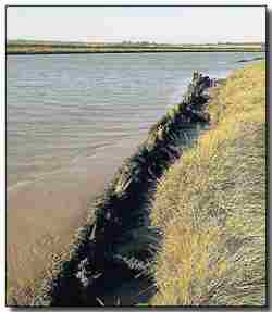
Old defences on the bank of the river at Reydon.
One of the many landowners acutely aware of the uncertain future facing the community is 70-year-old Andrew Hall, who runs a highly successful dairy farm at Reydon Marshes. Under the EA's proposals maintenance of the defences will be withdrawn after five years, meaning Mr Hall may have to sell his 250-strong herd of cattle based at Old Hall Farm.
Mr Hall, who also runs an arable farm at Metfield, said: "These defences were first built 300 years ago with hand labour and horses. Now we have all this modern machinery and they can't maintain them; it's ludicrous. We'll lose the 200 acres of marshland and we will probably have to sell the cows, which are my pride and joy. The dairy herd is a very important part of our business and contributes more per acre than the arable farm. I'm passionate about the marshes, the farm and the Southwold area. It's a lovely tourist spot and people like to see the cows on the marshes. I love this area and I can't speak too strongly about how I feel."
Mr Hall said the EA should allow landowners to carry out their own flood defence work, providing some funding. He also revealed how he sourced his own soil from contractors for no cost and used it to shore up the defences about a decade ago until he was stopped by the EA. "If they would give us just a small amount of money we would be happy for them to supervise what we do. I don't mind if it costs me a bit of money. We can continue to do it," added Mr Hall.
An Environment Agency spokesman said: "The consultation period is open until January 4 and we are accepting comments until then. We are glad people are getting involved in the process."
Pressure for a Marine Bill builds up
From Guardian Unlimited of Wednesday October 17 2007 comers this story by Jessica Aldred.
Petition marks renewed call for marine bill

Children representing the RSPB, the Wildlife Trusts, the Marine Conservation Society and WWF hand in the petition to No 10.
Photograph: Grahame Madge/RSPB
A coalition of conservation charities is to present a petition to Downing Street today, calling for the immediate introduction of a marine bill to protect the UK's seas. Some 250,000 people have signed the petition, which urges the government to include the bill in the Queen's speech next month. The campaign, by the Marine Conservation Society (MCS), the WWF, the Wildlife Trusts and the RSPB, has the backing of 117 MPs who have signed an early day motion calling for a marine bill.
The current laws governing the waters around the UK, which cover an area three times that of the land and are home to 44,000 species, are considered overcomplicated and costly. Nearly 40 separate acts regulate oil drilling, fishing and extraction of materials from the seabed, while fishing legislation has seen little change since it was introduced in the 1890s.
While the industries connected with the seas require licences and permits, these are issued by a wide range of organisations. Proposals for a marine bill, which would pull together the administration of all marine-related activities, whether industrial, commercial, recreational or conservation-based, has the backing of the big three political parties as well as environmental groups. It was first put forward in Labour's 2005 manifesto after lobbying from conservation groups.
In March 2006, the government published the first consultation document on its proposals for the scope and content of the bill, and invited feedback. In March this year it published a white paper, A Sea Change, which proposed eight offshore "national parks" within three years and as many as 80 highly protected sea areas.
The plans would also make it easier for developers to get permission to build offshore wind, wave and tidal schemes, and for power companies to bury carbon emissions in old oil and gas fields in the North Sea. The licensing of marine activities such as dredging will also be overhauled, as will the organisation of fisheries.
"Protecting our seas is one of the biggest environmental challenges after climate change and the two are closely linked," said the environment secretary, David Miliband. "These proposals are a first for the UK and would raise planning for the management and protection of our seas to a world-leading level."
Consultation on the white paper was completed in June. New figures released today by the Department for Environment, Food and Rural Affairs showed that 82% of the 8,519 responses to the consultation supported plans for a bill. Conservation groups have been highly critical of the length of time the government has taken to bring the bill before parliament.
Jan Brown, the senior marine policy officer at the WWF, said: "Our seas have been in decline for some time and it is imperative that the government addresses the urgency of the situation and introduces a marine bill now. "The facts are inescapable - our seas are in crisis. We need to act and cannot afford another year of delay by the government."
In July, a minister wrote to the Guardian in response to a comment piece which accused the government of putting the marine bill plans in "cold storage".
Jonathan Shaw, the minister for marine, landscape and rural affairs, promised that the bill would be published "in draft" early next year. "Far from being in 'cold storage', the planned marine bill remains a priority for this government," he wrote. "We are committed to a marine bill in this parliament and a draft bill is expected early next year.
"Because it is such a complex issue and we think that it is essential to take a strategic approach across the whole of the UK, working together with all the devolved administrations, it is vital that we get it right rather than rush such an important new vision for our seas and marine life."
Four children representing the four organisations in the coalition will hand in the marine bill petition to Downing Street today
Nationwide Petition for a Marine Act
The Wildlife and Countryside LINK, represented by the RSPB/The Wildlife Trusts/Marine Conservation Society/Whale and Dolphin Conservation Society, has presented a petition with 300,000 signatures to Downing Street calling for a Marine Act in this year's Queen's Speech. The petition has placed an emphasis on the need for marine reserves. Further details about the petition can be viewed here.
The petition is also supported in Parliament by EDM 1833, currently signed by 117 MPs, which can be viewed here.
EU Report says 80% of fish stocks are over-fished
A confidential report to the EU Report, which the EU Fisheries Director does not wanted published, says that overcapacity in the EU fishing industry and a failure of the regulatory system in Brussels has resulted in about 80% of EU fish stocks being overfished at the present time, compared with 25% worldwide. David Symes, University of Hull and one of the authors of the report is quoted as saying "Over the past 25 years the European institution have presided over an unparalleled period of decline for Europe's fishing industries" and he blames a lack of will by politicians and bureaucrats to stand up to fishing interests. It is believed that this confidential EU report will form the basis for a review of the CFP over the coming months.
For further details, see www.msnbc.msn.com/id/20999075
More villages sacrificed to demands of the SMP
The following article by Alasdair McGregor appeared in the Eastern Daily Press of 28th September 07. By pure chance, a high tide combined with a deep barometric low and a severe sustained nort-north-east gale stripped the regions beaches of sand cover right down to the marl that day, also breaching sea defences further up the coast.
Money for flood defences will run out

Flood defences could be abandoned on the Suffolk coast, affecting places like Southwold
Controversial proposals to abandon flood defences along a vulnerable section of the north Suffolk coast will leave 40 homes and thousands of acres of land at major risk, it has been revealed.
People living around the Blyth estuary in Southwold, Reydon, Walberswick and Blythburgh will today be told that the Environment Agency (EA) only has enough money to protect the defences against rising sea levels, sparked by climate change, for another 20 years.
The EA is consulting with residents and farmers about its flood defence strategy and has pledged to try to assist them with protecting their homes and land where possible, but has also admitted that some areas of the flood wall may have as little as six months to five years left.
The policy will also leave the main A12 between Lowestoft and Ipswich at major risk of frequent flooding and Environment Agency officials are consulting with traffic chiefs to look for a solution.
David Collins, the EA's project executive for the Blyth Estuary Strategy, said: "We've got a 20-year period where we are doing as much as we can, but we've got to be realistic and honest about what we can promise local people beyond that. There is no more we can offer in terms of repairing and rebuilding defences. "Over the next 100 years, sea levels are going to rise and we have to be realistic about what we can do."
The eventual disintegration of the estuary's flood defences will also have a major impact on local beauty spots, with the Hen Reed Bed succumbing to the rising waters while Tinker's Marsh will moved from being freshwater to saltwater. Mr Collins said the agency would work with conservationists to build a replacement for the Hen Reed Bed elsewhere.
The Environment Agency's consultation document shows:
- It will maintain defences downstream of the Bailey Bridge for about 20 years;
- Over the next five to 20 years, the agricultural defences fronting Reydon and Tinker's marshes are likely to fail, meaning flooded farmland will become tidal;
- There will be increased flows through the harbour impacting on its use for recreation and business;
- Failure of the defences will result in significant changes to the network of footpaths around the estuary;
- Buss Creek may be strengthened to help protect Town Marsh;
- Town Marshes, which houses Southwold caravan park, is likely to be flooded within 20 years.
Mark Johnson, the Environment Agency's area flood risk manager, revealed £100,000 had been spent on repairing the estuary's flood defences during the past year and that an outlay of £2m over the next 10 years was predicted. He said the agency received national funding from the government, but that not enough money was available to fund every flood defence across the country. "We simply can't afford it and difficult decisions have to be made," he added.
Sue Allen, a Waveney District and Southwold Town councillor, said: "This is a very special area and I cannot believe the Environment Agency will let this area go just like that." Mrs Allen is also a member of the Blyth Estuary Group, which works to maintain the estuary and harbour areas, added the possibility of self-funding projects would be investigated.
People can hear more about the plans at two public drop-in sessions today and tomorrow. Today's event will take place from 2pm to 7pm at Walberswick Village Hall, off The Street, Walberswick. Tomorrow's session will take place from 10am to 4pm at Reydon Village Hall, in Lowestoft Road.
Suffolk coastal villagers react angrily to SMP
Protest against the ethically unfair ramifications of the Shoreline Management Plan continues to escalate. This item written by Chris Hill comes from the Eastern Daily Press of 29th September 07.
Homes may be left to the sea
Villagers in Corton reacted angrily to a coastal scheme which could allow 100 properties to crumble into the sea during the next century. Homeowners said they felt "abandoned" by the Shoreline Management Plan adopted by Waveney councillors on Thursday which downgrades the protection of their village, leaving homes and businesses at the mercy of the sea.
The defence strategy for Corton, near Lowestoft, was changed from "hold the line" to "managed realignment", meaning that although some localised works will still be carried out, the existing line of defences will not be replaced when they reach the end of their lifespan in 20 to 30 years.
Forecasts for the resulting coastal erosion show that 40 buildings will be lost from the land on the seaward side of Corton Road and The Street by 2055. By 2105, a further 60 properties in the village could be claimed by the receding cliffs.
Coastal planners said that government policy dictated there was insufficient financial justification to invest in protecting the village, but studies were under way to relocate those affected. Alistair McLeod, 65, and his 63-year-old wife Joy bought a three-bedroom house 100 metres from the clifftop on The Street last year. "We have been abandoned," said Mr McLeod. "We bought the house and completely refurbished it on the understanding that the defences would be maintained. If this is their plan then they have completely devalued our property. If we wanted to sell this now it would be impossible." Mrs McLeod said: "It is really disturbing - it affects our whole financial situation."
Coastal officers were forced to review the earlier policy of holding the line at Corton when heavy scouring of the beach between 1999 and 2002 proved that it was not sustainable. Government grants only allowed enough money for the existing 20-year sea wall, which was built in 2005 at a cost of £3.5m.
Julian Walker, principal service manager for coast protection, said: "There is not sufficient development and economic value in that area to justify government funds to undertake very high-cost coastal defences in the future. It might cost £10m to give protection to the Corton village frontage. Unfortunately, the value of the houses that scheme would protect does not come up to that figure. It is a government requirement that you do not spend more money to protect than the value of the houses. There are heavy constraints and we have got be realistic." Mr Walker said property owners would be offered help with relocation, but current legislation meant that compensation was not payable for property lost to coastal erosion.
David Butcher, chairman of Corton Parish Council, said: "There is a mortgage blight on the east side of our high street caused by the drawing of this 100-year line and it is not fair on the people who live there."
English Heritage Survey shows Peoples value of our coast
The BBC News website of 12th October shows that the vast majority of those polled value our coastal heritage.
Coast towns 'should be preserved'
Two-thirds of people believe seaside resorts are at the centre of national identity but many feel they have become run down, a survey suggests. The English Heritage survey found more than 75% of 1,003 respondents believed seaside towns were shabby. Many also thought the government should invest more in preserving what is good about the country's coastal resorts. A total of 77% said the historic character of seaside towns was what made them beautiful and enjoyable.

Margate is said to have undertaken successful regeneration
Dynamic resource
The survey was published ahead of a two-day conference on England's seaside resorts to be held next week at Hastings, Sussex.
Academics, social historians and policy makers will take part in the event to highlight the problems coastal towns face. They will also discuss how seaside resorts can reinvent themselves without betraying their heritage.
English Heritage has also just published a report describing how heritage can be "a dynamic resource for regeneration". The report highlighted 15 coastal towns where historic assets have been used to underpin successful regeneration and economic diversification.
The towns include Hastings, Margate, Whitstable, Folkestone, Morecambe, and Great Yarmouth.
English Heritage chief executive Simon Thurley said: "Investing in the historic core of seaside towns is the essential first step in revitalising communities and giving residents a home with a soul. From fishing alleys to Victorian boulevards, from old docks and harbours to historic spas, we have lots of evidence to show that people and businesses flourish in places where local character and distinctiveness are being revived, often through physical renewal and re-use of historic buildings." He added: "It is clear that seaside towns need to adapt and evolve. The historic environment should be recognised as an integral part of the search for a strengthened identity and a better future. It is what makes them loved, welcoming and unique in the first place, and provides a natural economic, geographic and civic focus for their regeneration."
Concern from Scotland
The BBC News website gives the following item under: http://news.bbc.co.uk/2/hi/uk_news/scotland/6981595.stm
Exhibition shows coastal threat
A photographic exhibition which aims to highlight the plight of Scotland's threatened coastlines is opening. The event, organised by Scape (Scottish Coastal Archaeology and the Problem of Erosion), features award-winning images taken by members of the public.
Earlier this year Scape, which is based at St Andrews University, staged the Capturing the Coastline competition. The exhibition is going on display at the headquarters of the National Trust for Scotland in Edinburgh. Historiographer Royal in Scotland, Professor Christopher Smout, will join renowned photographer Colin Prior and Environment Minister Michael Russell to launch the event.
'Preserving Scotland'
Professor Smout, who will also chair Scape, said: "These lovely pictures show what the coast means to us. It is tragic that so much of the archaeology, which can tell us how our ancestors lived in this environment, is now at serious risk of destruction from increasing storms and sea level change. The archaeological sites are like a book that is being torn away page by page unread."
Children and adults took part in the competition, with Simon Powis from Tayport taking the prize for over-16s.
Play a part
The winning junior effort, by Joe Niven from Unst, was awarded £500 worth of prizes.
After its initial showing at the National Trust for Scotland, the exhibition will visit a range of venues, including the Scottish Parliament and the Gateway in St Andrews over the coming year.
Mr Russell said it was important for everyone to play their part in preserving Scotland's coastline. He added: "I have spent much of my life living in site of the sea and, for me, Scotland's coastline is infinitely varied, fascinating, in all conditions and weathers, yet also now, in many places, fragile and at risk."
Wildlife Trust on Marine Reserves
The BBC News website placed the following news http://news.bbc.co.uk/1/hi/wales/7037104.stm
Reserve call to protect coastline
Areas of coastline should be protected marine reserves where fishing, dredging and oil exploration would be banned, The Wildlife Trusts has said.
The conservation body is calling for the Marine Bill to be included in the next Queen's speech.
The Menai Strait between Anglesey and Gwynedd and Skomer Island off Pembrokeshire are two areas they say could benefit as fully protected zones.
The body referred to reports of a drop in dolphins around the Welsh coastline.

It is claimed reserves would create healthier breeding environments
The Wildlife Trusts' Lisa Chiltern said the introduction of marine reserves could help stop the reduction in dolphin numbers, along with helping other wildlife like seals and basking sharks.
"Marine reserves can contribute to marine life in a number of ways," she said. "Firstly, they can help protect wildlife [that live] in the actual reserves, which is great for species attached to the sea bed. They can also help mobile species, like dolphins, seals and basking sharks, by creating far healthier environments for them to give birth."
In a report, the organisation has named 15 sites around the UK which they say illustrate how marine reserves would protect wildlife.
"The UK's marine environment has been exploited intensively, increasingly intensively I should say, for decades," Ms Chiltern added. "And there's increasing pressure from commercial fisheries, from development, for energy, including renewable energy and so on. There are lots of signs that things are not well."
The Wildlife Trusts have been campaigning for many years for legislation to better protect UK waters, home to more than 44,000 animal and plant species, from corals to basking sharks.
In March the government launched the Marine Bill which, as well as creating protected areas, aims to improve the regulation of inshore fisheries and ease planning for offshore industry.
The Wildlife Trusts are calling for this bill to be included in next month's Queen's Speech - a step towards it becoming legislation - and for it to include the creation of marine reserves.

The Menai Strait has been named as an area which needs a reserve
Ms Chiltern said: "There are protected areas already around the UK in our seas, including off the Welsh coast in Welsh territorial seas, but these do not provide a very high level of protection. They're multi-use areas where fishing and dredging and other activities frequently continue."
Government relaxes on SMP insistence
As detailed in the following press article, the government have given a degree of recognition of the social justice required in their stance on the Shoreline Management Plan. Ten million pounds will not go near far enough, but if instead of highly expensive concrete sea walls and constant beach refurbishment it is spent on more modern sustainable methodology which are one tenth of the cost, it will certainly help the situation. Eastern Daily Press, 15th October 2007
Government promises erosion cash
The government has finally bowed to years of pressure from persistent Norfolk lobby groups and set aside millions of pounds to help communities at risk from coastal erosion, it was revealed last night. The surprise move is in the small print of the heavyweight pre-budget report and comprehensive spending review published last week. It commits a pot of £10 million to help communities deal with the consequences of flooding and coastal erosion where the construction of defences is not deemed "appropriate".
The allocation of the money was last night welcomed by leading climate change and coastal campaigners, who described it as "joyous". The figure of £10 million would not be sufficient as a long term solution, said the campaigners, but they stressed an important principle had been established in official policy for the first time.
The government pledge stops short of using phrases such as "compensation" and "social justice", instead using the word "adaptation" - but it represents a significant turn around, said Malcolm Kerby, coordinator of the Happisburgh based Coastal concern Action Group, which now campaigns on an international stage. "This is huge, a momentous step forward, quite joyous. It is the single most important development for the benefit of coastal communities for many years," said Mr Kerby. "Our problems are not solved, but for the first time we can see there is going to be some kind of assistance on the table for those people who are suffering. We never had that before".
"It is not clear what this will translate as, how it will shake down, and the pot is wholly inadequate, but at this stage that is not the point - it is now written in tablets of stone that the government is prepared to provide financial assistance to communities who are facing this dreadful plight. Bear in mind as well that this has been announced in one of the most important policy documents of the year."
North Norfolk MP Norman Lamb said a new principle had been established: "This is the first sign of a breakthrough for the many years we have been putting forward the argument for social justice. "It is far too early to be confident we will reach a satisfactory conclusion, but it is crucially important that the government has accepted the principle of helping people in these situations. It is a dramatic piece of news and I share the excitement with those people on the coast directly affected. We now enter a new stage of the process."
A meeting arranged with environment minister Phil Woolas for the end of the month now took on a whole new importance, said Mr Lamb, with further clarification vital.
Both Mr Lamb and Mr Kerby said they felt the new policy was the direct result of a collective effort in north Norfolk, involving politicians, North Norfolk District Council, CCAG and communities at threat such as Happisburgh.
"Unanimity has won this major battle," said Mr Kerby.
And Mr Lamb said: "No one else in the country has been arguing this case other than the group in Norfolk." That group included Mr Kerby and the communities he represented, the district council and climate change expert Tim O'Riordan, said Mr Lamb.
The district council's head of coastal strategy Peter Frew, said he was "very pleased indeed" at the news. "We will have to wait and see how it would work, but I would like to think the district council can be involved in any pilot schemes or associated works."
Aggregate dredging may be threatening Sizewell nuclear power station
Peter Lanyon, Vice-Chairman of the Shut Down Sizewell Campaign, Suffolk, has written a paper where he documents the evidence and concern that the offshore sandbanks, which protect Sizewell beach from the effects of climate change, may be under challenge from offshore aggregate dredging. For further details, see: www.marinet.org.uk/mad/sizewell.pdf
Lyme Bay conservation status damaged by scallop dredgers
Following evidence that fishermen dredging for scallops have damaged the marine habitat and conservation status of Lyme Bay, Dorset, the UK government (Defra) has announced that it is undertaking a public consultation on the measures required to protect the conservation importance of the Bay. The Consultation Document, which records why Lyme Bay is a possible Special Area of Conservation (SAC) under the Habitats Directive and also records the range of protection options available, can be downloaded from the Defra site as a pdf file.
Comments must be made to Defra by 7th December 2007.
FOE Cymru says No to Severn Barrage
Friends of the Earth Cymru is opposed to a large-scale tidal barrage in the Severn Estuary and believes that, in addition to the adverse environmental impact on the estuary, the investment required for such a large project would starve other new generating technologies of funds and Government support. See FOE Cymru Report: www.foe.co.uk/cymru/english/news/severn_barrage_report.html
Opposition to the Severn Barrage is also being maintained by WWF Cymru and RSPB Cymru, and RSPB Cymru believe that the barrage will only be 23% efficient (less efficient than the average on-shore wind farm).
Source: Renew No.169 Sept/Oct 2007.
UK Sustainable Development Commission reports on Tidal Power
The Sustainable Development Commission (SDC) has carried out a comprehensive study of tidal power in the UK, including an evaluation of proposals for a Severn barrage. The SDC believes tidal resources could provide at least 10% of the country's electricity.
The SDC believes the Severn barrage could supply 4.4% of the UK's electricity (17 TWh) and generate electricity for over 120 years, thus securing significant climate change and energy security benefits. However the SDC recognises that up to 75% of the existing tidal habitat in the estuary would be lost if a barrage were built, and this habitat is currently protected under the EU Habitats and Wild Birds Directives.
With regard to Tidal Stream energy, the SDC recognises that the UK has a superb resource and that technologies aiming to exploit this resource need Government support in order to realise the potential export and climate change benefits which are "very large". On Tidal Lagoons, the SDC finds that there is currently an absence of practical experience with this technology and calls upon the Government to support a development project.
For further details of the SDC Report, visit: www.sd-commission.org.uk:80/pages/tidal.html
Tidal turbine for Strangford Lough is "on the way"
The 1.2 MW marine current turbine, owned by SeaGen, is now about to be installed in N.Ireland's Strangford Lough which, itself, is one of the UK's only 3 marine nature reserves. This commercial demonstration project, with permission to operate for 5 years, was due to be installed in August. The delay has been due to the late arrival of the Danish jack-up barge which will transport SeaGen's marine current turbine from a shipyard in Belfast to Strangford Lough.
The SeaGen turbine consists of two wing-like rotors, 15m to 20m in diameter, which are located underwater in the tidal stream and are fixed onto either side of a tubular steel monopile. The monopile measures 3 metres in diameter and is set into a hole drilled in the seabed. The rotors turn slowly at 10 to 20 rpm. This rotation is 10 times less than the speed of a ship's propellers and is therefore not anticipated to cause any harm to marine mammals who are experienced in swimming in strong tidal currents and, physically, have excellent perceptive powers and agility. Martin Wright, managing director of the company Marine Current Turbines which manufactured SeaGen hopes, if the Strangford Lough trial is successful, to manufacture marine current turbines on a large-scale with the turbines grouped in arrays as with wind turbines.
Source: Renew No.169 Sept/Oct 2007.
UK takes a lead on offshore wind
The world's largest wind turbine in offshore deep water has just been installed in the Beatrice field which lies 25km off Scotland's east coast. The turbine, which is the first of two, is 85 metres high, generates 5 MW and is supplying its electricity to the nearby Beatrice platform.
Also the world's largest offshore wind farm, known as the Atlantic Array, has been announced in principle by Farm Energy. The proposed site is located off the North Devon coast and will host 350 turbines, generating 1.5 GW and will cost an estimated £3 billion to build. The world's current largest offshore wind farm is the London Array located in the Thames estuary, generating 1 GW.
Source: Renew No.169 Sept/Oct 2007.
Cornish Wave Hub secures RDA funding
The SW Regional Development Agency (RDA) has approved £21.5 million funding for the Cornish Wave Hub. The Wave Hub, which could be built as early as next summer, provides a high voltage cable, with connections, located on the seabed 10 miles out from Hayle, Cornwall. Marine energy companies will be able to test their devices and, by connecting to the Wave Hub, feed their electricity into the National Grid. Three energy companies are already working with the RDA to make use of the Wave Hub once it is constructed. Fears that the Wave Hub could interfere with the offshore wave regime, and thus the height of waves for surfing, appear to be unfounded. Dr. Kerry Black, a New Zealand based physical oceanographer, believes the loss in wave height will be less than 5% (less than five centimetres off a metre high wave). About half of the RDA's approved funding of £21.5m is expected to come from the European regional Development Fund.
Source: Renew No.169 Sept/Oct 2007.
Fighting for their shoreline
From 'North Norfolk News' of 6th September 07 comes some welcome news that North Norfolk Council has taken a stand against the demands of DEFRAs inconsiderate Shoreline Management Plan. Lowestoft and Waveney Council, who are promised funding, have capitulated, whilst the decision of Great Yarmouth Borough Council whether or not to adopt the proposal to adopt the ACAG Sub Cell 3b SMP will be made at their full council meeting on November 1st. 2007.
Already Ormesby St. Margaret & Scratby, Somerton and Hemsby Parish Councils have now all held special public meetings on the adoption of this SMP with GYBC Councillors in attendance, and they all agreed to reject it in its current form. Caister and Gorleston Parish Councils will hold public meetings on this subject soon. It is suspect that they may support its adoption as the policy for their units in this SMP is " Hold the Line".
Council's demand for erosion-hit areas
A raft of measures to help erosion-threatened seaside communities face their fate is being demanded by North Norfolk's campaigning district council. It is the only way the embattled coastal area will accept a controversial new shoreline management plan, whose new policies could put thousands of properties at risk. Half a billion pounds worth of homes and businesses could potentially be lost to erosion and sea flooding under moves to abandon almost all the existing sea defences in north Norfolk.
The district council has been among those vocally opposing the emerging shoreline management plan (SMP). But it is now saying it would "conditionally" accept the master plan - providing there are measures in place to help the communities affected. That could range from compensation to individual property owners, to relaxing planning guidelines to allow communities to expand inland.
But North Norfolk District Council's cabinet member for coastal issues Clive Stockton stressed the change of stance was not a question of caving in. "We have accepted there is no way of practically defending the whole of the north Norfolk coast. So we must find a combination of policies, which includes measures to ensure there is social justice for those areas which cannot be defended. We are not Luddites. But we are also not prepared to roll over and give in. We must find a pragmatic and workable way forward."
Only the main resorts of Cromer and Sheringham, along with the nationally-important gas terminal at Bacton, and the vulnerable Winterton area, were earmarked for ongoing protection in the new SMP. Other places face "realignment" - by letting aging defences crumble and nature take its course over the next 50 years. The areas most needing help to mitigate against possible policy change were Overstrand, Mundesley, Bacton, Walcott, Ostend, Eccles and the Runtons.
People who had chosen to live in areas which were previously defended, and now finding themselves the victims of new policy, had been "conned," said Mr Stockton. He was heartened the government, which was previously "deaf" to the calls for social justice, was now looking at an "adaptation toolkit" looking at issues such as the property price and development blight caused in communities by failing sea defences.
Compensation was being discussed, along with the possibility of the government buying threatened property to give owners their equity back, while leasing it back to tenants to keep it lived in until it became unsafe. A softening of planning guidelines could also help seaside villages expand into greenfield areas to stop the community shrivelling and dying.
Up to 1,000 coastal properties could be lost and a further 2,500 inland if the sea broke through, added Mr Stockton.
Digging in its heels to seek help for communities could take years admitted Mr Stockton, but the council was spending £200,000 a year for the next decade, to buy time at villages whose defences were struggling to cope. Happisburgh was strengthened last year, and this year it was Overstrand's turn.
The SMP was also flawed because its decisions on what to protect or defend were based on "facile" economic tests which only looked at the face value of properties, and did not include infrastructure such as roads and sewerage, the value of businesses, or the less tangible factors such as heritage and community cohesion.
The council is also urging the government to research the impact of an intermittent system of defences, which could lead to a saw-tooth series of headlands and bays, which upset the flow of sand along the coast.
Council cabinet will be asked to agree the new stance next Monday, and the issues will also be raised when a delegation visits new environment minister Phil Woolas on October 31.
More losses threatened by SMP
An additional threat is shown to the Suffolk Coast and one of the most beautiful areas in Britain in this article entitled 'New Threat to Suffolk Coast' written by David Green in the East Anglian Daily Times on 3rd October 2007.
New Threat to Suffolk Coast

River Blyth likely future shape if flood defences are abandoned. Dark blue current spring tides - mid-blue after 5 years - light blue beyond 20 years
LANDOWNERS fear more stretches of coast will be abandoned to the sea as the result of a review of flood defences along the whole of Suffolk's shoreline. A review of coastline defences between Felixstowe and Lowestoft has just started - with the Environment Agency facing tough decisions over the priorities for spending Government money.
The agency recently announced that low-lying land in the Blyth Estuary will not be defended in future because of costs and unsustainability in the face of climate change forecasts of sea level rise and increased storm surges. This could lead to the loss of hundreds of acres of land and 40 isolated homes. A similar strategy is likely to be announced for the other Suffolk estuaries, including the Alde/Ore and the Deben. Now, consultations are starting on the shoreline review of the North Sea coast, with fears that a "retreat" policy will result in further losses.
The County Land and Business Association (CLA) yesterday criticised the methodology currently used by the Government to assess the cost/benefit of sea defence schemes. The association claims the cost/benefit calculations being applied to the review of shoreline management plans (SMPs) were "inefficient, short-sighted and with severe implications for coastal defence throughout England".
It argued that in considering a "retreat" policy the assessment should not only take account of the value of agricultural land behind the defences but the value of tourism and other businesses and countryside recreation and the risk to infrastructure, including the A12 road.
Jane Burch, CLA regional advisor, said the fundamental philosophy of the SMPs was flawed and that they were written in isolation without regard to other coastal plans. She warned that once a coastline was lost it is unlikely ever to be recovered. "Cost/benefit calculations that determine that the Government should put off the task of securing the coastline until the last minute are inefficient and short-sighted. "Once our defences have been neglected over a long period of time they will inevitably become more costly to repair, let alone replace," she said. The management plan process needed to start from the principle of retaining the coastline's assets, rather than one of retreat.
"SMPs cannot achieve their full role in rural areas while infrastructure and community assets, agricultural land, heritage and commerce are undervalued in the analysis of costs and benefits and while necessary long-term investment is made to appear uneconomic," Mrs Burch added.
Steve Hayman, coastal manager for the Environment Agency said that although there were Government guidelines on working out the cost/benefit analysis of flood defences they were by no means restricted to the value of agricultural land. "They take into account a wide range of issues, including social issues. There is a fair amount of scope to look at the wider implications," he said.
However, realism was important. "It would be totally wrong for us to hold the line of existing defences if we couldn't justify the funding to do it," Mr Hayman added.
SMP Threat to Suffolk
More homes and scenic area are to be lost in Suffolk if the government are allowed to have their way, as pointed out by this article 'Estuary defences - fears for more homes' by David Green, East Anglian Daily Times 1st October 2007.
Estuary defences - fears for more homes
Hundreds of low-lying homes in Suffolk will be put at increased risk of flooding if the Environment Agency extends its "do nothing" sea defence policy option to all of the county's estuaries, campaigners fear.
The agency confirmed last week - three years after proposals were first drawn up - that it was proposing to stop maintaining earth embankments along stretches of the Blyth Estuary, effectively removing protection from 40 isolated homes.
With management plans for the rest of Suffolk's estuaries - including the Alde/Ore and Deben - due to be finalised over the next two years, "hold the line" campaigners fear hundreds of homes will be put at risk of increased flooding.
They accuse the Environment Agency of rushing into an "abandon the coast" strategy on the basis of 100-year climate change predictions of sea level rise and more tidal surges.
The agency is arguing its limited sea defence budget should be focussed on protecting centres of population - not poured into remote areas where, it believes, defences have now become unsustainable in even the medium term.
Deep concern about the direction of coast defence policies was expressed at the weekend at the official launch of Suffolk Coast Against Retreat (SCAR), which aims to harness the combined strength of organisations and individuals to campaign for the present line of defences to be maintained.
The launch came at the end of a week in which the Environment Agency had confirmed it did not intend to continue to maintain earth embankments along some stretches of the Blyth Estuary.
David Andren , chairman of the Alde and Ore Association, claimed yesterday many homes alongside the Alde/Ore estuary alone could be exposed to floods.
"We believe hundreds of homes surrounding the Alde and Ore Estuary could be put at risk if, as seems likely, the Environment Agency follow the same approach as they have on the Blyth," he said.
Parish, district and county councillors and members of estuary interest groups were among more than 50 people who attended the launch of SCAR at the home of Suffolk Coastal MP and former Environment Secretary, John Gummer.
Graham Henderson, SCAR chairman, said the Environment Agency had rushed into an "abandon the coast" policy - putting land and homeowners at risk of losing their property without compensation.
"We think the line of the coast should be held for the next 20 years so that further monitoring of changes can take place and to give the opportunity for new coastal defence technology to come forward. Global warming is like a big hammer that is falling on us. The Environment Agency is trying to make decisions based on a 100-year climate change scenario. The coastline should be maintained until we have more knowledge," he said.
Mr Henderson said he understood the agency's flood defence budget was limited and it was for the Government to come up with the necessary money. However, about £1.5 million had been spent over the past three years in drawing up a shoreline strategy in Suffolk - money which could have been used to bolster some of the deteriorating defences, he said. It was also unfair, Mr Henderson argued, that under a European Union directive money had to be made available to compensate for loss of important wildlife habitat while no such compensation was available for land and homeowners. "We are not anti-environment but we are looking for equal treatment for property owners," Mr Henderson said.
Simon Whitehead, whose home beside the Blyth Estuary will be one of those properties exposed to increased flooding risk, said, although the Environment Agency would continue maintaining the Reydon marsh walls for five years, he had been told if a breach occurred during that time it would not be repaired.
Rita Penman, Environment Agency spokeswoman, said the proposed policy had not been drawn up without a great deal of computer modelling and study of tide heights, available for years ahead. "When we build sea defences we base them on a 100-year forecast and it is the same when we make decisions about maintenance of existing defences. We also carry out exhaustive consultations. In no way are decisions rushed."
Council sets conditions for Shoreline Management Plan compliance
Contrary to the unconditional acceptance of the DEFRA imposed SMP by Lowestoft and Waveney Council, who have defence money allocated, North Norfolk have set conditions mainly on the social and ethical requirements.
Council sets conditions for accepting sea defence plan by Richard Batson, Eastern Daily Press 3rd September 2007.
A campaigning council is demanding a raft of measures to help erosion-threatened seaside communities face their fate. It is the only way the embattled coastal area will accept the controversial new shoreline management plan, whose new policies could put thousands of properties at risk.
Half a billion pounds worth of homes and businesses could potentially be lost to erosion and sea flooding under moves to abandon almost all the existing sea defences in north Norfolk. The district council has been among those vocally opposing the emerging shoreline management plan (SMP).
But it is now saying it would "conditionally" accept the master plan - providing there are measures in place to help the communities affected. That could range from compensation to individual property owners, to relaxing planning guidelines to allow communities to expand inland.
But North Norfolk District Council's cabinet member for coastal issues Clive Stockton stressed the change of stance was not a question of caving in. "We have accepted there is no way of practically defending the whole of the north Norfolk coast. So we must find a combination of policies, which includes measures to ensure there is social justice for those areas which cannot be defended. We are not Luddites. But we are also not prepared to roll over and give in. We must find a pragmatic and workable way forward."
Only the main resorts of Cromer and Sheringham, along with the nationally important gas terminal at Bacton, and the vulnerable Winterton area were earmarked for ongoing protection in the new SMP. Other places face "realignment" - by letting ageing defences crumble and nature take its course over the next 50 years. The areas most needing help to mitigate against possible policy change were Overstrand, Mundesley, Bacton, Walcott, Ostend, Eccles and the Runtons. Up to 1,000 coastal properties could be lost and a further 2,500 inland if the sea broke through, added Mr Stockton.
Digging in its heels to seek help for communities could take years admitted Mr Stockton, but the council was spending £200,000 a year for the next decade, to buy time at villages whose defences were struggling to cope. Happisburgh was strengthened last year, and this year it was Overstrand's turn.
He was heartened the government which was previously "deaf" to the calls for social justice, was now looking at an "adaptation toolkit" including issues such as blight caused in communities by failing sea defences. Compensation was being discussed, along with the possibility of the government buying threatened property to give the owners their equity back, while leasing it back to tenants to keep it occupied until it became unsafe.
Council cabinet will be asked to agree the new stance next Monday, and the issues will also be raised when a delegation meets the new environment minister Phil Woolas next month.
New Research - but is it independent?
From 'Dredging News on Line' comes this story that HR Wallingford obviously seeks to better assess and monitor "the environmental effects of dredging, and is currently engaged on a number of research projects to develop better predictive models and assessment procedures in this field." After reading this you can visit Wallingford's maritime dredging efforts here.
HR Wallingford acquires Dredging Research Limited - Dredging News Online - October 10, 2007
HR Wallingford has acquired Dredging Research Limited in the UK. DRL will operate as an independent group within HR Wallingford, providing a broad range of services in research and consultancy associated with dredging, reclamation and dredged material placement. From 1 October 2007, DRL will be based at HR Wallingford's Howbery Park campus in Wallingford, Oxfordshire.
"The new DRL Group will take primary responsibility for all of our work concerned with dredging, reclamation and disposal" said Dr Jane Smallman, Managing Director of HR Wallingford. "We have a long history of collaboration with DRL, and this acquisition strengthens and enhances HR Wallingford's capability in dredging services. We are very pleased to welcome DRL to the company."
"In all respects the business will continue much as before" explains DRL's Director, Nick Bray. "Joining HR Wallingford allows us to make a number of improvements in key areas, including additional staff capability and a broadening of our technical base. We will also have the ability to draw upon HR Wallingford's extensive experience and expertise in closely related fields."
Nick Bray will continue in his present role as Director of DRL, and he will be joined as a Director by HR Wallingford's Dr Mike Dearnaley. The DRL Group at HR Wallingford will be managed by Michael Costaras.
Dredging Research Limited was formed in 1989 and provides a multi-disciplinary advice and practical research service to all sectors of the dredging industry. DRL's extensive international track record includes some of the most prestigious dredging works in the world, including the Masterplan for the new Hong Kong Airport and major port developments in the UK, Middle East and South East Asia. DRL has been at the forefront of assessing and monitoring the environmental effects of dredging, and is currently engaged on a number of research projects to develop better predictive models and assessment procedures in this field.
Tidal Power SDC Verdict
Strong reservations over the Severn Mega-Barrage,
enthusiasm over the UK's tidal power generally - SDC verdict
The Sustainable Development Commission (SDC) study of tidal power in the UK, includes an evaluation of proposals for a Severn barrage. But, contrary to the headlines, it sits on the fence on this while giving more encouragement to tidal power projects that give quicker results, particularly tidal stream turbines.
The SDC's report, Tidal Power in the UK, www.sd-commission.org.uk/ includes a series of recommendations to Government on how to develop our tidal resource, and emerging tidal technologies, to provide secure, low carbon electricity for the long term.
A Severn Barrage
A barrage in the Severn Estuary could supply 4.4% of UK electricity supply (17TWh) from the second greatest tidal range resource in the world, generating electricity for over 120 years. Developing a Severn barrage would result in significant climate change and energy security benefits.
However, it would have a major impact on the local environment, with the loss of up to 75% of the existing intertidal habitat, which is internationally protected. There would also be a number of impacts on local communities and the regional economy, and a high risk that unsustainable ancillary development would take place alongside any barrage project. The SDC has therefore laid down a series of tough conditions which a Severn barrage would have to meet in order to be considered sustainable.
These include:
- A Severn barrage must be publicly led as a project and publicly owned as an asset to avoid short-termist decisions and ensure the long-term public interest
- Full compliance with European Directives on habitats and birds is vital, as is a long-term commitment to creating compensatory habitats on an unprecedented scale
- Further investigation of the 'environmental opportunity' that might exist for combining climate change mitigation with adaptation through a habitat creation package that actively responds to the impacts of climate change over the long term
- Development of a Severn barrage must not divert Government attention away from much wider action on climate change.
Tidal Stream
The UK also has an excellent tidal stream resource, and is leading the world in the development of a wide range of tidal stream devices, several of which are at the testing stage. The UK must 'stay the course' in developing these technologies, as the export and climate change benefits are potentially very large.
Despite the encouraging progress made so far, Government could do more to assist these emerging technologies, particularly through flexible financial support, and by providing additional resources to the European Marine Energy Centre in Orkney.
Tidal Lagoons
On tidal lagoons, the SDC found that there is a lack of available evidence on the costs and environmental impacts, mainly due to the absence of any practical experience. We have called on Government to support the development of one or more demonstration project, which would help provide real-life data on their economic and environmental viability.
This project was announced in the 2006 Energy Review in response to the business lobby for the Severn mega-barrage. But the study ranged broadly over the various tidal energy opportunities. It concluded the UK has outstanding tidal resources, which could provide at least 10% of the country's electricity.
The SDC commissioned five desk-based research reports to inform the work, and received a large volume of evidence from a wide range of organisations and individuals. They also undertook a programme of public and stakeholder engagement to explore opinions and attitudes towards tidal power in the UK and the Severn Estuary resource. The final reports of the SDC commissioned work can be downloaded here - www.sd-commission.org.uk/pages/tidal.html
Last week the government pre-empted the SDC report, declaring that a Severn barrage scheme would be "visionary". As no doubt intended, it set the spin for the media.
Media comment - with pro-barrage bias:
02/10/07 Guardian Severn barrage could generate 5% of UK energy, says watchdog
01/10/07 BBC Advisers approve tidal power plan
29/09/07 The Times The rushing tide of change that divides Britain's conservationists
Lowestoft MP takes up the cudgels on Coastal Erosion
From the Eastern Daily Press of 10th October comes this story by Chris Hill of the ongoing efforts to protect the East Anglian coastline in the face of government intransigence. Now the MP for Lowestoft joins in the fracas.
MP to take erosion plight to ministers
Clifftop villagers left at the mercy of the sea by new coastal defence plans were given fresh hope yesterday as an MP vowed to take their plight to the government.
Plans adopted by Waveney District Council last month downgraded the protection policy for Corton, near Lowestoft, to one of "managed realignment" with 100 properties predicted to be lost to erosion during the next century. Coastal protection offers said strict government guidelines meant that they could not spend more money on defences than the value of the properties they were protecting, so could not justify the potential £10m cost of reinforcing the sea wall at the end of its 20-year lifespan.
And with Defra officials refusing to offer compensation for the homes and businesses left exposed by the plans, Waveney MP Bob Blizzard said he would speak to ministers in an attempt to save the village from falling into the sea. He said: "I can't see any sense in letting a place of that size fall into the sea. We have defended it for the foreseeable future and I believe we should continue to defend it beyond that. Rather than get into a conversation about compensation all the effort should be put into defending the village." Mr Blizzard said property-owners had a right to expect their protection to continue after gaining a sense of security from the £3.5m spent in 2005 to build the current defences.
A Defra spokesman said they had no obligation to pay compensation for homes lost to coastal erosion - even those which had previously been protected with government funding.
Waveney accepted the Shoreline Management Plan covering the coast from Kelling to Lowestoft on September 27. Labour councillor John Shanahan tabled an amendment committing the council to investigate compensation, but this was rejected by the Tory-run council who claimed that five working groups were already in place. Ken Sale, Waveney's portfolio holder for the built environment, said: "We are working on this in other ways. If we put that amendment in the plan they would totally ignore us. We are fighting tooth and nail for these people and we are going to lobby all we can to get compensation and other land for those people with the problems."
Danger of discarded fishing nets highlighted
Environmental campaigners yesterday called for new laws tightening up the way marine life is protected after disturbing images were released of sea creatures which had suffered a lingering death after becoming trapped in a discarded fishing net. An amateur diver came upon creatures including a dogfish, spider crab, wrasse and even a cormorant trapped in the 60-metre-long net. Dave Peake was snorkelling 50 metres off Polhawn Cove at Whitsand Bay in south-east Cornwall when he discovered the underwater death-trap. "It was sickening to see this net in six metres of water and everything dead," he said. "The net could have been lost or discarded. The birds would not see the net when they dived for the fish, and they would have suffered a slow death.
For further details, see www.guardian.co.uk/environment/2007/oct/04/conservation1
Coastal campaigner's court victory
From the Lowestoft Journal of 15 September 2007 comes this further episode in Peter Boggis's valiant attempt at DIY coastal protection and denying the shoreline aggregate to the offshore dredging demand.
A CONSERVATION agency's plans to let the sea erode cliffs in the cause of science, despite fears that homes will be destroyed, are to be challenged at the High Court. Natural England wants a fossil-bearing area on the Suffolk coast to be allowed to wear away, exposing strata of soil and rock for study.
But resident Peter Boggis, a retired engineer, built his own coastal DIY defences to prevent erosion and save his home and those of his neighbours. Last night he won permission at London's High Court to challenge moves by Natural England to stop him maintaining the barrier on the grounds that the area has been declared a site of special scientific interest (SSSI).
Mr Boggis, 76, who lives at Easton Bavents, near Southwold, is now locked in a complex legal battle which could have wider implications.
Nicholas Blake QC, sitting as a deputy High Court judge, gave Mr Boggis permission to seek judicial review. Judge Blake ruled Mr Boggis had an "arguable case" that should go to a full hearing as it raised issues of importance that could affect other areas of coastline that are eroding.
Mr Boggis said later: "I am relieved that it appears we stand a chance, in due course, of getting justice."
Scientist hails Firth potential in tidal energy
Adapted from the John O'Groats Journal
TIDAL energy in the Pentland Firth could be converted to supply Scotland's power needs twice over, according to a leading scientist.
Professor Stephen Salter, of Edinburgh University, claims tidal energy potential in the far north may have been significantly underestimated and has urged the new Scottish government and industry leaders to invest more resources in research.
Please click here to read as more on this as a pdf file.
The Sustainable Development Commission will report on tidal power this autumn
How will the Commission report? Tidal News for MARINET introduces our updated "Tidal Power in the Severn" and includes the Ecostar argument (large pdf file) for a strategic rethink on the basis that tidal rises around the coast allow design of several schemes that in combination have the valuable ability to match patterns and surges in demand.
Welsh dredging decision comes under fresh attack
From 'Dredging News on Line' 19th September '07 comes this article of the ongoing concern of dredging of the Gower coastline. MARINET spent much time and effort addressing this issue, writing to the press, the media and members of the Welsh Assemply of our concern. www.sandandgravel.com/news/article.asp?v1=10356
A decision to allow almost two million tonnes of sand to be dredged from a sandbank off the Gower coast has come under renewed attack.
According to a recent report on This is South Wales, Councillors from all parties in Swansea backed a Conservative motion to try to put an end to dredging on the Helwick Bank.
"Swansea Council wants independent research to be carried out to see what effect the dredging has on the area. It has called on the Assembly to support demands for Environment Agency Wales to appoint an independent body to carry out monitoring, rather than a company appointed and paid for by the firm carrying out the dredging," said the report.
The motion states that the council had "deep disappointment" at the licence decision.
"It is claimed that beaches on Gower are vanishing and campaigners say the loss of sand is primarily down to dredging," said the report.
The motion goes on to say: "This council is also concerned at the prospect of further applications for the dredging of 1.8 million tonnes a year of sand over the next 15 years from the Bristol Channel, just off Worm's Head."
Conservative councillor Rene Kinzett said he was delighted that the motion had been passed. "While the motion clearly lays the blame for the decision to go ahead with the dredging at the feet of the Labour/Plaid Cymru-controlled Welsh Assembly Government, it is clear that local councillors from all parties are against further extraction of aggregate from the Swansea and Gower coastline," he said.
The council is now waiting for a report from Dr Philip Barber, which will be reported to an extraordinary council meeting on October 4.
The motion passed by the authority states that the council "believes that it would be improper for the dredging company (Llanelli Sand Dredging Ltd) to commission its own monitoring".
Council leader Chris Holley told This is South Wales: "It's not just dredging, there's other things raping the sand off our beaches and we should put a stop to it."
Too much of coast sacrificed
The following is a letter published in the Eastern Daily Press, 12th September 07, from Gt. Yarmouth FOE & MARINET member Mike King. The letter makes its point although a significent section of the original letter was edited out. The full submitted letter can be viewed here.
Malcolm Kerby's statement (letter, September 8) that so far as the government (Defra) is concerned the technical aspects of the Shoreline Management Plan are "written on tablets of stone" is correct and reinforces my statement (Letter August 28) that the basic policy will not be changed irrespective of the conditions of acceptance requested by local authorities or any consultation with local groups.
With the exception of Eccles to Winterton Beach Road. which is the responsibility of the Environment Agency all the remaining units along the Norfolk coastline are the responsibility of either North Norfolk District Council or Yarmouth Borough Council.
Both now recommend accepting this SMP (subject to consultation and conditions), but because the technical aspects will not be changed I can not understand his support for a SMP which advocates sacrificing most of Norfolk`s coastline to the sea.
What happened to the proposed alternative to this SMP, a proactive document with input from local communities and action groups?
Plastic waste a serious threat to marine wildlife
The Marine Conservation Society has identified waste plastic items as a serious danger to the health of all marine wildlife and has organised, with the help of volunteers, a clean-up of plastic items from UK beaches. "Of all the hazardous materials littering our seas today, plastic poses the greatest threat," said Emma Snowden, project officer of the Marine Conservation Society, which is organising the clean-up. "It causes death and injury to hundreds of thousands of seabirds and marine species every year through swallowing and entanglement. Items of particular danger to marine wildlife include plastic bags, drink cans and fishing nets."
For further details, see the Guardian of the 16th September 07
Council's dealing with DEFRA's demands
From North Norfolk News of 6th September 2007 comes the latest on how the councils of area threatened by DEFRA's latest dictate are dealing with the situation.
Council's demand for erosion-hit areas
A raft of measures to help erosion-threatened seaside communities face their fate is being demanded by North Norfolk's campaigning district council. It is the only way the embattled coastal area will accept a controversial new shoreline management plan, whose new policies could put thousands of properties at risk. Half a billion pounds worth of homes and businesses could potentially be lost to erosion and sea flooding under moves to abandon almost all the existing sea defences in north Norfolk.
The district council has been among those vocally opposing the emerging shoreline management plan (SMP). But it is now saying it would "conditionally" accept the master plan - providing there are measures in place to help the communities affected. That could range from compensation to individual property owners, to relaxing planning guidelines to allow communities to expand inland.
But North Norfolk District Council's cabinet member for coastal issues Clive Stockton stressed the change of stance was not a question of caving in. "We have accepted there is no way of practically defending the whole of the north Norfolk coast. So we must find a combination of policies, which includes measures to ensure there is social justice for those areas which cannot be defended. We are not Luddites. But we are also not prepared to roll over and give in. We must find a pragmatic and workable way forward."
Only the main resorts of Cromer and Sheringham, along with the nationally-important gas terminal at Bacton, and the vulnerable Winterton area, were earmarked for ongoing protection in the new SMP. Other places face "realignment" - by letting aging defences crumble and nature take its course over the next 50 years. The areas most needing help to mitigate against possible policy change were Overstrand, Mundesley, Bacton, Walcott, Ostend, Eccles and the Runtons.
People who had chosen to live in areas which were previously defended, and now finding themselves the victims of new policy, had been "conned," said Mr Stockton.
He was heartened the government, which was previously "deaf" to the calls for social justice, was now looking at an "adaptation toolkit" looking at issues such as the property price and development blight caused in communities by failing sea defences.
Compensation was being discussed, along with the possibility of the government buying threatened property to give owners their equity back, while leasing it back to tenants to keep it lived in until it became unsafe. A softening of planning guidelines could also help seaside villages expand into greenfield areas to stop the community shrivelling and dying.
Up to 1,000 coastal properties could be lost and a further 2,500 inland if the sea broke through, added Mr Stockton.
Digging in its heels to seek help for communities could take years admitted Mr Stockton, but the council was spending £200,000 a year for the next decade, to buy time at villages whose defences were struggling to cope. Happisburgh was strengthened last year, and this year it was Overstrand's turn.
The SMP was also flawed because its decisions on what to protect or defend were based on "facile" economic tests which only looked at the face value of properties, and did not include infrastructure such as roads and sewerage, the value of businesses, or the less tangible factors such as heritage and community cohesion.
The council is also urging the government to research the impact of an intermittent system of defences, which could lead to a saw-tooth series of headlands and bays, which upset the flow of sand along the coast.
Council cabinet will be asked to agree the new stance next Monday, and the issues will also be raised when a delegation visits new environment minister Phil Woolas on October 31.
MARINET members warn Great Yarmouth Council not to accept the current Shoreline Management Plan
DEFRA has told Great Yarmouth Borough Council that it should accept the current version of the Shoreline Management Plan which establishes "managed retreat" as the sea defence policy along the Norfolk coast or risk the forfeiture of sea defence money for Great Yarmouth itself. MARINET members in Norfolk have accused DEFRA of blackmail in this matter, and advised the Borough council to reject DEFRA's proposals. For full details of MARINET members' comments, see www.marinet.org.uk/coastaldefences.html
Britain's damaged Seas and the need for the Marine Bill
From The Times of August 3rd. 2007 comes this article by Ben Macintyre on Britains rape of the sea and the urgent need of an effective Marine Bill.
Britannia's cruel treatment of the waves
In the blood of every Briton runs at least a little seawater. We sing of the sea, romanticise our maritime heritage and regard the beach holiday as a nationally affirming birthright. Every year we potter in our millions down to the sea with bucket, spade, snorkel, jet-ski, paperback, shark defence kit and inadequate quantities of suncream.
Oh, we do like to be beside the seaside; but we have a strange way of showing it. For the past 300 years or so, we have poisoned and plundered the sea; we have destroyed the seabed, killed the fish and bemired the vast oceans with our waste.
We wring our hands at the pollution and devastation we have visited on the land, but because we cannot see what is happening beneath the dark waters surrounding this island we somehow assume it will mend itself.
Every so often a tar-soaked seagull pricks our marine conscience, but then the waves close over our fears again; the waves, it must be said, look much the same as they did in your youth, but they are not.
On every 100m of British coast there are, on average, 117 separate pieces of plastic. The North Sea cod, most notoriously, has been fished to extinction. Pockets of sea are dying, deprived of oxygen, suffocated by algae. Each British bottom trawler ploughs up some 13 square miles of seabed on an average fortnightly fishing trip. This, warns Richard Girling in his terrifying new book, Sea Change, is a way to earn a living that is approximately equivalent to "harvesting rabbits by bombing the Chilterns".
Up to half of Britain's entire biodiversity, some 44,000 species, exists in the fertile, shallow sea around Britain. This year the WWF estimated that of 16 key marine species and habitats all but two are in decline in UK waters.
While other countries have moved to protect their seas, for the past 25 years the waters around Britain have been systematically neglected and mismanaged. Australia has declared one third of the Great Barrier Reef a "no take zone"; New Zealand has 28 protected sea zones, while America, often an environmental laggard, has established numerous protected areas in either ocean. There are more than 500 marine preserves in the Philippines alone.
In British waters, by contrast, less than 1 per cent of the sea is afforded any protection whatever, and in much of that commercial fishing continues unabated. Latvia, with barely 300 miles of coast, has more marine reservations than Britain, with its 7,800-mile coastline. Lundy Island, off the Devon coast, was designated a marine nature reserve in 2003, one of just three small zones with limited protection from intensive fishing.
Lundy, however, is home to a small miracle. Around the island, after just five years of protection from trawling, the sea has started to recover: fish stocks have increased steadily, the variety of species is expanding within the safe zone, while lobsters around Lundy are said to be up to seven times larger, on average, that those in the neighbouring unprotected areas. In this tiny aquatic Utopia, the sea is coming back to life.
For most marine scientists, the implications are clear. The deterioration of the sea can be slowed if not halted by setting aside conservation areas. Quite how much of the sea would need to be preserved for sustainability is a matter of debate - some scientists argue that for every intensive fishing zone an equal area should be designated a "no take zone" - but the principle of defined marine parks is one that even the British Government, after years of neglect, appears to have hauled on board.
Earlier this year, Defra published a White Paper that laid out, for the first time, a comprehensive plan for protecting Britain's marine environment and managing the entire delicate ecosystem. The marine Bill is the most sensible addition to British maritime life since the invention of the lighthouse: it envisages a series of protected national parks, perhaps rising to as many as 90 in all, including such sensitive areas as Dogger Bank and Scotland's fragile coral reefs.
The Bill is not simply some worthy Magna Carta for beleaguered British fish, since it also sets out clear rules for exploiting the sea by fishermen, oil prospectors, dredgers and energy farmers. The Bill will make it far easier to build and operate offshore wind farms, developments to harness wave power, and schemes for storing carbon emissions from power stations in former oilfields. So far from ducking the issue, as successive governments have done, the marine Bill aims to balance competing interests and face up to the inevitable but not insoluble conflict between exploitation and preservation.
But in politics, as at sea, the weather changes quickly. The marine Bill, promised in Labour's manifesto of 2005, was expected to become law within a year, but suddenly it seems to have slipped off the political agenda. Gordon Brown did not even mention marine protection in his summer statement, and the marine Bill is not included in his planned legislative programme for next year. The Bill has been kicked into the long seaweed. It is the big one that got away, again.
And so the steady despoliation of our seas - overfished, hopelessly underdefended, beloved in theory but abused in practice, a shared resource that is gradually being wrecked for all - continues. Only by protecting our marine habitats can we hope to preserve the livelihoods that depend on them - and our endangered taste for fish and chips.
We look back with nostalgia and pride on a time when Britannia ruled the waves. Britain's failure, in modern times, to set rules for what goes on beneath its waves should be a source only of shame.
Recycled Glass bottles for saving our beaches
From US/Eastern News of August 12th 2007 comes a story of a most innovative and excellent form of recycling that could save our authorities a fortune, save our shorelines and our marine ecosystem and overcome the problem of glass disposal to boot. That this would also place cohesive granular material back on our beaches that would help arrest the sand draw down on our steepening and non-cohesive shores is yet a further advantage. http://cbs4.com/consumer/local_story_234142623.html
Broward's Sand Shortage May Be Solved With Glass
Picture a beautiful beach spanning miles of coastline, gently lapped by aqua-colored water, but sprinkled with glass? You'd think it might hurt but think again. It's actually sugary soft with sparkling granules that feel like, well, sand. And that's the point.
Faced with the constant challenge of keeping sand on Florida's beaches, Broward County officials are exploring an innovative option to use pulverized glass to control erosion. The recycled glass would be crushed into tiny grains and mixed with regular sand to patch erosion problems on the county's beaches before they wash away. And it's only natural, officials say, since glass is made from melted sand. "Basically, what we're doing is taking the material and returning it back to its natural state," said Phil Bresee, Broward's recycling manager.
The county would become the first in the country to use the process to dispose of recycled glass, bolster sand reserves and intentionally spread it on beaches, Bresee said.
Sand is a commodity in South Florida, where beach-related business generates more than $1 billion a year for Broward alone. It has traditionally been dredged from the ocean a mile offshore and piped onto beaches, about 13 million tons of it since 1970 in Broward. That's enough sand to fill the entire Empire State Building more than 12 times over. But with the county's reef system restricting future dredge sites, available sand is becoming scarce and pricey as construction and fuel costs rise and dredge operations are pushed farther offshore.
In 2005, a dredge operation brought in about 2.6 million tons of sand at a cost of $45 million. By comparison, a 1991 dredge operation brought in about 1.3 million tons of sand for $9 million.
The recycled glass market also is lagging from low value, Bresee said. "The goal of this project is to spearhead a synergistic approach to the glass recycling challenges as well as beach nourishment ... We're certainly blazing the trail," he added. "It's unclear how much the project would cost the county, whether it would be cheaper to just sell the glass or even if the project is feasible as Broward doesn't have its own plant to process the glass. The state and county have so far spent about $600,000 on tests and engineering".
"And while the glass sand project wouldn't solve the county's problem of limited sand supply, it would create a reserve to plug beach "hot spots" like pot holes before they become critically eroded", Bresee said.
A typical large dredge project brings in about 2.6 million tons of offshore sand. The county would create just 15,600 tons of the glass material each year.
Most of Broward County's 24 miles of beaches are considered critically eroded, in largely because of coastal development and offshore channelizing. Statewide, more than a quarter of Florida's 1,350-mile coastline falls into the same category. About $80 million is spent annually restoring Florida's beaches, but it's a constant challenge as storms sweep away sand and coastal development continues.
"The sand that is still there is just getting harder to get," said Paden Woodruff of the state Department of Environmental Protection. Woodruff said the glass sand project would have multiple benefits. "You reduce waste stream that goes to our landfills and you generate materials that could be available for our beaches," he said.
The idea grew from the unintentional consequences of an ocean dump site off Northern California near Fort Bragg. In 1949, officials began dumping garbage over a cliff into the ocean -- everything from old cars to refrigerators and glass, said Charles Finkl, a marine geologist with Boca Raton-based Coastal Planning and Engineering. Finkl said that while organic material degraded over the years, the glass broke apart and became smooth in the surf. The area is now known locally as Glass Beach. Another accidental glass dump site in Hawaii produced similar results, Finkl said. "You talk about glass beach and people have images of sharp glass shards but it's not that way at all," he said. "Mineralogically, its the same as natural sand." While Broward's plan would first crush the glass into sand-sized grains before spreading it on the beach, the California and Hawaii sites show it's not just a pipe dream, Finkl said.
A similar technique has been used to create sandy beaches using glass along Lake Hood in New Zealand and on the Dutch Caribbean island of Curacao.
Broward County tested a small patch of the glass sand on Hollywood's beach last year, using sensors to measure humidity and heat. Scientists have also conducted laboratory tests that show organisms and wildlife can live and thrive in the glass material just like natural sand, they said. The county is now awaiting a permit to place the glass sand in the surf zone to see how it reacts in the waves.
But the science is simply too new to truly know of any long-term consequences, said Dennis Heinemann, a senior scientist with the Ocean Conservancy. "There's no way that you can predict all the environmental consequences of an action like this," Heinemann said. "There always will be unforeseen consequences."
The state and Broward County are currently spending millions to remove some 700,000 old tires from the ocean floor off Fort Lauderdale that were dumped there in the 1970s with the good intentions of creating an artificial reef. It didn't work, and now the tires are scouring the ocean floor and wedging against the natural reef, killing coral. A lesson learned the hard way.
Stephen Higgins, Broward's beach erosion administrator, said disastrous side effects from the glass sand are highly unlikely. "If we were going to construct an entire beach out of glass, I would be a little more concerned," Higgins said. "But our test results show there were no discernible differences between the glass-sand blends and the 100 percent natural beach sand."
MARINET asks the Marine and Fisheries Agency when the aggregate dredging regulations will be placed on a statutory basis
Following the public consultation in July 2006 about a statutory basis for the aggregate dredging licensing procedure (MMG2), MARINET has now asked the MFA when this statutory basis (Act of Parliament) will be given to the procedures, see the 3 letters dated 8th July 07, 16th July 07 and 20th August 07 at www.marinet.org.uk/mad/mmdr.html
MARINET believes the Government may be improperly enforcing the aggregate dredging licensing procedure for Area 436
MARINET has asked the Marine and Fisheries Agency (Defra) to check whether the licensing procedures (Marine Minerals Guidance Note 1) have been properly applied when the aggregate dredging licence for Area 436 expired recently, see the 4 lettters dated 10th April 07, 11th July 07, and 28th August 07 (2) at www.marinet.org.uk/mad/objection.html#202
MARINET asks Government about appeal procedures over aggregate licence for Area 401/2
After a prolonged period of correspondence with the Government over the shortcomings of the EIA for a renewed aggregate extraction licence for Area 401/2, MARINET continues to believe that its concerns have not been properly addressed, and is now asking the Marine and Fisheries Agency (Defra) whether it can appeal against the licence decision, see the 3 lettters dated 26th July 07, 7th August 07, and 28th August 07 at www.marinet.org.uk/mad/objection.html#401
Unusual winds and groyne problems for cliff man
From the pages of the Eastern Daily Press of 29 August 2007 comes this story by Chris Hill of Peter Boggis's valiant attempt to save the coastline.
The retired engineer who built his own coastal defences said yesterday that the recent improvements at neighbouring Southwold had exposed his section of cliff to a tenfold increase in erosion.
Peter Boggis had 250,000 tonnes of clay soils delivered to protect a 20km section of the coastline near his home at Easton Bavents in Suffolk.
But he claimed that the £8m rebuilding of Southwold's groynes and sea wall, which was formally completed in July, had led to 40pc of his "soft sea defence" being washed away since the winter. Waveney District Council, which made the improvements in partnership with the Environment Agency, attributed the increased beach scouring to a change in the prevailing weather conditions.
But with conservation agency Natural England preventing further building by declaring the beach a Site of Special Scientific Interest (SSSI), Mr Boggis is unable to replenish his DIY defences, and is asking the High Court to overturn the restrictions.
Mr Boggis said: "It is very important that the cliffs at Easton Bavents are protected, not only to ourselves, but also for Southwold because, as the cliffs erode away, Southwold would become an ever more exposed promontory and, therefore, much more difficult to protect than it is today."
Paul Patterson, senior coastal engineer at the district council, said: "The circumstances that led to the massive loss of Peter's sacrificial fill were unusual. "In January and February, the winds were blowing from south to north almost constantly and the force of the wind was not typical. This created a tendency for sand to be lost to the north, and the new groynes prevented sand from coming in from the south to replace it. It is unreasonable to judge the project over the course of one year."
Last July, English Nature (now Natural England) renotified the SSSI zone to protect wildlife habitats along eight miles of coastline from Pakefield to Easton Bavents, prompting Mr Boggis to seek a judicial review to allow his work to continue. The date of the first hearing will be set on September 14.
Sewage set for sea near Lowestoft
Eastern Daily Press, 25th August 2007
Environment chiefs are set to allow minimally-treated sewage to be pumped into the sea off Lowestoft to allow for vital repairs at a water treatment centre. A public consultation was launched in May after Anglian Water (AW) revealed plans to reduce the amount of treatment it carries out on sewage for about six months at its Lowestoft Waste Water Treatment Centre at Corton.
Last night a spokesman for the Environment Agency said the finishing touches were being put to the licence and that permission for AW to proceed with the £1.5m project was imminent.
The plans had come under fire from environmental groups, but AW insists the work is safe and will not compromise water bathing standards off the north Suffolk coast.
Environment Agency spokesman Richard Woollard said careful consideration was given to the licence, which AW wants to run from October to April to avoid the main holiday season. He added: "We haven't issued a licence yet, but it is imminent. We are in the process of drawing it up and we are in negotiations with Anglian Water at the moment."
The £70m water treatment plant at Corton was opened in 2001 and is different to most other sewage plants because it is fully enclosed to prevent smells blighting local residents' lives and also to make it less of an eyesore.
However, its design means that corrosive gases have been harder to disperse, which has caused a quicker deterioration of equipment than would be expected at traditional plants. AW water has revealed plans to use an old pipe system, known as the long sea outfall, to pump water further out to sea off Ness Point.
Spokesman Andrew Mackintosh said the work at Corton was important to maintain bathing water standards in the long term.
He added: "As far as we are concerned everything is going according to the timetable. The work needs to be done and this is the most sensible way of doing it. What we are doing is going back to the way it was seven or eight years ago and it was perfectly safe then. The impact should be very, very minimal."
The work had initially been opposed by the North Sea Action Group (NSAG) and the Marine Environmental Information Network (Marinet). Pat Gowen, a spokesman for both groups, questioned whether AW's actions were in breach of EU laws over the quality of water pumped out by treatment centres, but was told that the Environment Agency could grant temporary consent for less treated sewage to be pumped into the sea. Yesterday, he said: "They are saying they are doing it for the long-term good, so I think I probably agree with that. But I want them to put up notices warning people there is untreated sewage going into the sea. If they fail to do that it would be a very bad reflection of them."
Mr Mackintosh from AW said the possibility of putting up signs was still under discussion.
Tidal Power for the UK - the Severn estuary debate
Should we be building tidal barrages, tidal lagoons or marine curent turbines in the Severn estuary and around UK coasts in order to make sound use of the renewable energy available from the sea? Which technology is best, offering cost-efficient and reliable electricity generation and an acceptable environmental impact?
A MARINET member takes a careful look at the facts and myths in this important debate, see www.marinet.org.uk/refts/7estuarydebate.html
Conservatives work to preserve Walney coast
The following excerpt is part of a letter from Cllr Bill Joughin of Barrow Borough Council published in the North-West Evening Mail of the 15th August 2007
Speaking of the Labour party in general and Councillor Anita Husband's letter on this matter in particular, may I remind her that the problem of coastal erosion has been with us for a number of years, and when the Labour party controlled the council, and indeed had six district councillors and two county councillors on Walney, this problem was ignored by them for many years. As leader of the council, I can advise Walney Ward voters that it is no coincidence that since they elected two Conservative councillors on Walney, their problems are being addressed, by the interventions of councillors Mike Jones and Oliver Pearson, not least the improved bus service to North Scale and indeed the efforts that have been made over the past six months by our council officers to persuade English Nature and the various government agencies to give us authority to carry out even the emergency works we would seek to do.
This continuing and often frustrating work, and the money to pay for consultants reports to get to even this stage, has been provided by a Conservative-led administration and it is indeed ironic that after failing to take any action for many years while the Labour party had full control of the council, Councillor Anita Husband, like some latter-day carpetbagger, now seeks to claim credit for her party for the painstaking actions, undertaken by my administration.
May I say that our council officers are actively seeking a solution to the legal impediments presently preventing the work being done and when that solution is found I trust they will be applauded by those who have seen fit to criticise them.
Plaid Cymru opposes Gower dredging
The following is a quote from a longer article from the Western Mail of 21st August 2007
Yesterday, in a letter to a local paper, Plaid AM Dai Lloyd attacked Swansea Council's Liberal Democrat leader Chris Holley for suggesting that Plaid backed further sand dredging off the Gower coast. Mr Lloyd said in his letter, "Let us make one thing abundantly clear. Plaid have consistently opposed the dredging on the basis that until robust investigation shows that there is no effect on Gower's beaches, then the precautionary approach should prevail. This will continue to be Plaid's stance. Councillor Holley knows full well that the decision as to whether the dredging should continue rests solely with the Minister for Sustainability.
"That Minister is Labour's Jane Davidson, so Councillor Holley's statement, that this was in part a Plaid decision, is simply political game playing."
Sea defences are not enough
From the East Anglian Times 30th July 2007
PRESSURE groups have welcomed plans to bolster sea defences along a stretch of Suffolk coast as of "short-term" benefit - but have called for more action to address the underlying cause of coastal erosion.
The North Sea Action Group and Marinet, the Marine Network of Friends of the Earth Groups, said restrictions on both off-shore mineral extraction and the deepening of shipping channels were needed.
Pat Gowen, spokesman of both groups, said he was delighted "a degree of common sense had prevailed" in the decision by Suffolk Coastal District Council to back a scheme at East Lane, Bawdsey.
It would see defences bolstered, financed by the private sale of land for local housing.
However, the plans - to dump rocks to protect the local cliffs from the action of waves - was only likely to produce a short-term alleviation of the current level of erosion, he said.
"Rock protection is in vogue. While it does most certainly reduce the loss, the rocks slowly sink and the sand between, behind and below will still reduce," he said.
This had been shown by the scheme at Caister-on-Sea in Norfolk, where the initial rock line had now sunk and an additional line of rocks had been placed behind them.
For long-term sea defence it was necessary to address the main causes of the erosion, he said.
"This would mean halting the loss of the shoreline material to the demands of offshore aggregate dredging and the reducing the impact of port deepening such as that at Felixstowe," Mr Gowen said.
Other measures that offered great benefits for stabilising and rebuilding beaches and shorelines included the provision of far less costly but more effective "soft" defences, such as the building of dunes planted with marran grass.
Mr Gowen added: "For many centuries now the East Anglian coastline has been slowly eroding for natural reasons.
"Apart from the effects of the onslaughts of major storms and surges, this has been a steady but nevertheless relentless regression.
"Beaches normally show sand loss over the winter months because the strong onshore northerly winds create an undertow taking the mobile sand and shingle out to sea.
"Where once it was brought back to the shore by the opposite south to south-west summer winds, this previous balance now is mainly lost. Since the onset of Offshore Aggregate Dredging the traffic seems to be one-way only."
The off-shore aggregates industry points out that independent studies have shown there is no evidence of a link between off-shore aggregate extraction and coastal erosion.
The Department for the Environment, Food and Rural Affairs (Defra) has also discounted claims that the deepening of shipping channels has aggravated coastal erosion.
Dimethyl Sulphide's rôle in climate regulation is confirmed
Dimethyl Sulphide (DMS) is a chemical compound emitted by micro-marine organisms, and is marine biology's most common form of sulphur. Sulphur, an essential basic element, is washed out of soils into the sea and begins its return to land as dimethyl sulphide via marine organisms whose respiration emits DMS into the atmosphere where it is converted into sulphate particles around which water droplets and clouds form, thus eventually returning the sulphur back to land as rain. Thus DMS plays a crucial role in the climate and biology of the planet, and is believed by Gaia theorists to be an essential regulatory process. Similar cycles also return other essential elements from the sea to land e.g. selenium and iodine.
For further details, listen to Material World, BBC Radio 4
Worldwide Ban on TBT finally agreed
Tributyltin (TBT) is a chemical compound which, when mixed into paint, will kill algal and barnacle growth and thus act as an anti-fouling system on the hulls of ships. However the chemical is also highly toxic to many marine organisms and, even at low concentrations, it causes deformations and genital changes in marine animals. The decline in the commercial oyster industry is attributed to the use of TBT. TBT has been used as an anti-fouling agent by shipping fleets for many years, although its negative environmental impact was known 40 years ago and there was general agreement that it should be banned 7 years ago. Now a sufficient majority of nations in the United Nation's International Maritime Organisation (IMO) have agreed to this ban, and the IMO will be introducing a global ban in 12 months time.
For additional details, see WWF website
Beach worries over dredging
BBC News website has a 3 minute audio/video interview with people along the Welsh Gower area concerned that offshore aggregate dredging is damaging their Gower beaches.
To hear please click on this link.
MARINET member argues strongly for Great Yarmouth to reject local Shoreline Management Plan
MARINET member Pat Gowen, based in Norwich, has written to the Gt Yarmouth Borough Council drawing attention to the following news article that appeared in the Eastern Evening News on 20th August 2007. Pat's comments to the council appear after the article.
Demise of Great Yarmouth's Golden Mile
Eastern Evening News 20th August 2007
Great Yarmouth is in danger of not having a beach within the next 100 years, while 170 homes along the coast will be lost to the sea by that time, according to a report.
With the spiralling costs of coastal defences, a plan has been devised which will protect important centres along the coast - but that could be at the expense of other sections. The Shoreline Management Plan was commissioned by North Norfolk District Council, Great Yarmouth Borough Council, Waveney District Council and the National Rivers Authority and recommends what action should be taken.
Barry Coleman, leader of Great Yarmouth Borough Council, said it was frustrating that government funding to pay for coastal defences was dependent on the plan being adopted. For Great Yarmouth itself the recommendation is to continue to hold the line and protect the town, but the report states that by 2105 there could be little or no beach unless action is taken elsewhere.
But things could be even worse for people living in the Eccles to Winterton Beach Road area, where the suggestion is mooted for some land to be surrendered to the sea in the future. The report states: "The exposure of this coastline means that technically and economically it will become increasingly difficult to hold the present shoreline position in the longer term. Eventually beaches will become impossible to retain in their current position, even with continual re-nourishment, as sea-level rise and coastal squeeze results in higher exposure of the shoreline defences".
Experts suggest a more sustainable approach could be to retreat the defence line and allow a natural beach to form, although they admitted: "This would result in the loss of properties and farmland in the floodplain."
Other areas which could see properties lost to the sea include Corton, Newport, Scratby, Caister and Hopton.
On Wednesday Yarmouth's cabinet is expected to agree that forward planning is put in place to address the issues for the people whose property would be affected. Mr Coleman said: "What we are hoping will happen is that members will accept the new management plan which will allow funding to come in, but that we will make clear we have reservations."
Pat Gowen's comments to the council regarding the above article.
Assuming this report to be accurate, the assumption that Great Yarmouth and the surrounding area will lose it's beaches 'within a hundred years' is in MARINET's opinion both myopic and highly optimistic. If offshore dredging continues, the new Outer Harbour dredges for deep water access, if no functional forms of defence are installed and the government continue to fail to provide the needed protection, thirty years of life (or even less) is far more likely. You will recall that the erosive demise of Happisburgh was twelve times that predicted by EA and DEFRA 'experts'.
It now appears that in order to force through the rejected and highly unpopular 'Managed Retreat' policy of abandonment of coastal villages, businesses and housing to the sea without the provision of compensation, the Environment Agency is, backed by DEFRA and cosy with BMAPA, intent on seizing the responsibility for coastal protection away from the local councils and experts who far better understand the situation. It further now appears that the EA and DEFRA are in effect blackmailing Great Yarmouth Borough Council into accepting their unethical and already rejected Shoreline Management Plan.
As you will well be aware, Public Consultation on the SMP ran until 29th April 2005. This welcomed 'comments' on the document from all members of the impacted community. By the end of the consultation period over 2,000 such comments resulted, when it was admitted that all but three consultees were vehemently opposed to their 'plan'.
I think, following DEFRA's strategy - or rather the lack of it - in permitting and then poorly dealing with the recent inland flooding, their lack of control over offshore aggregate dredging, their failure to fund vital defences, means that DEFRA and the EA are the very last people who are qualified to issue edicts on coastal protection and flooding. They have completely failed to heed expertise and advice given them in public consultations and by many independent international expert coastal geomorphologists, and they have blundered on with their totally mistaken 'Managed Retreat' policy, which has lead us to the unacceptable Shoreline Management Plan. It is hard to believe that the GYBC Cabinet can even contemplate agreeing to the government's Shoreline Management Plan. when so much is at stake.
As aforesaid, for DEFRA and the Environment Agency to refuse to fund coastal protection for Great Yarmouth unless the SMP is adopted equates to blackmail. It would mean the loss of our wildlife sites, our dunes, coastal trade, our best beaches, valuable farmland and much coastal housing, all without compensation to the losers, at great cost to the infrastructure and at great loss of income dependent upon the attraction of our beaches and coastline. The sole beneficiaries will be the dredgers who will have more sand and gravel liberated from the coastline to exploit.
I do hope that the Council stand up for their rights and those of their constituents tomorrow.
Meaningful points for use on the SMP and coastal defence are to be found by going to: www.marinet.org.uk/coastaldefences/smp.html
That missing sand!
Thanks to the Eastern Daily Press of 13th August publishing an amazing revelation by Chevrolet, we at last know just where all that sand from our denuded beaches is going to. And there we were thinking that it might due to be the millions of tons dredged from our sea bed.
Grains of sand add up
Holidaymakers visiting the East Anglian coast are being urged not to drive sand home from the beach after new research out today suggests that Britons are likely to inadvertently take home enough of the yellow stuff to fill 25,000 family cars this year.
It comes as Norfolk is ranked seventh in a poll of the most popular beach destinations Britons will drive to this year.
The study says that as a nation we are expected to take more than 27 million UK beach holidays this year with three in five of us going green and shunning carbon-heavy flights abroad.
But, without thinking, people are likely to take home with them a total of 160,000 tonnes of sand, enough to fill 25,000 family cars.
The majority of the sand gets transported from coast to car via shoes and clothing, while around a third is carried in towels and blankets and 6pc gets stuck in hair and on the body. According to the research by vehicle maker Chevrolet, women carry on average 7kg of sand away with them every day, while men transport 5km. [I think they mean 5kg]
Chevrolet's Les Turton said: "It seems British seaside holidays are enjoying a resurgence in popularity, so much so that we are accidentally taking 25,000 amount of cars full of sand home with us. Driving holidays are a great way to discover Britain and also spend some quality time with the family. Just make sure if you're going to the beach you don't lose them under the surplus sand on the way back."
Study hope for coastal homes at risk
From the Yorkshire Post of 9th August 2007 comes this news by Alexandra Wood of a contoversial new study into the grave situation of erosion along Yorkshire's East Riding coastline. But it does rather remind one of what the Prince of Wales said in his opening speech at the North Sea Conference so many years ago "While the investigation continues, the patient may die"
A new study into the impact of coastal erosion could help in the battle for compensation for homeowners whose properties are lost to the sea. The findings of the £270,000 project will be used to update the controversial Shoreline Management Plan which advocated a "do nothing" approach a decade ago.
It said that nature was to be allowed to take its course along the East Riding's crumbling shoreline, apart from towns, including Withernsea and Hornsea, which would continue to be defended.
A report earlier this year said up to 70 more homes were under threat on the Yorkshire coast in the next 50 years. However, until now no financial aid has been available to those living on the East coast, and residents even have to pay demolition costs themselves. Campaigners say the Government should now set up a central fund for residents and coastal authorities.
The new two-year study - covering the coastline between Flamborough Head, in East Yorkshire and Gibralter Point in Lincolnshire - will take into account climate change and rising sea levels and show how the coast will look in 25, 50 and 100 years. Consultants Scott Wilson will carry out the technical modelling work but widespread consultation will be carried out with residents.
Paul Bellotti, East Riding Council's head of community and sustainable development, said the Government "couldn't ignore" the findings and would have to respond "one way or another".
He said: "It will provide new evidence to allow us to lobby Government for the right level of investment and that includes the Lincolnshire coast to either protect communities or hopefully bring the compensation they deserve. The Government, by virtue of them funding a significant plan, will want to hear and listen to the results and respond to it."
But fisherman Derek Crook, whose home at Tunstall has been lost to coastal erosion, said: "This is just ludicrous - people have said time and time again what they want. What's the point of spending well over a quarter of a million pounds on a study which won't achieve anything? The money would be better spent helping people move back from the clifftops."
The east coast is the fastest-eroding coastline in western Europe, disappearing at a rate of two metres a year to the south of Hornsea. Less than six miles have sea defences.
Professor John Pethick, the architect of the first SMP said even if the vast expense of concreting the coast could be justified, within a matter of years it would be toppling into the sea.
Better use for old hulks?
From the Sussex Express of 13th August comes this news that old warships may be sunk in Seaford Bay to help arrest erosion of the beach.
Sunken warships plan for bay
A plan to sink old warships in Seaford Bay to create an artificial reef could put the town on the tourism map.
Anthony Fowler, owner of the Tudor Manor Hotel in Seaford, has come up with a plan to sink 12 ex-naval warships after he was inspired by a similar scheme in Plymouth. He said the idea, which could cost millions of pounds, would boost tourism in the area, help prevent erosion of the coastline, encourage marine life and provide a haven for divers.
Mr Fowler, who is a keen diver himself, said: 'I have lived in Seaford all my life and Seaford used to have a fantastic beach with all the families down there. I read up about artificial reefing and found out about an example of this. The Navy has to stop pushing these ships off to different countries to get them scrapped so they have got to look at greener ways of disposing of them. All the toxins and scrap are taken out and you get an environmentally friendly way of getting rid of them which also protects the seafront. As an artificial reef it is going to stop waves bashing against the beach and enable us to develop our seafront. There is nowhere around here for diving like this. It could put Newhaven and Seaford on the map.'
Mr Fowler's plan was inspired by a similar scheme where a ship was sunk off Plymouth. The National Marine Aquarium used HMS Scylla in 2004 to create an artificial reef.
Mr Fowler said since Scylla had been sunk the area had made more than £1 million a year from tourism, mostly from divers visiting the area. Seaford Town Council was set to discuss the plan yesterday (Thursday) but said it would be contacting other bodies to see if it would be viable.
A council report proposes that the Newhaven Community Development Association (NCDA) be asked to evaluate the possibility of the scheme to see whether it could use its contacts to secure funding.
Leader of Seaford Town Council Jon Freeman said: 'The whole idea is to put Seaford on the map as a diving centre and it really does seem quite exciting. The difficulty is before we do that there must be a feasibility study into how much it would cost, how it would work and what effect it would have on the marine banks around there. That study is expected to cost between £50,000-£70,000. 'It would not be something Seaford Town Council could finance so we have looked to the Environment Agency and NCDA in the hope someone could give us a lead about how we could secure the money to do it. 'While it seems like a novel, creative and imaginative plan we have to get the funding from somewhere.'
Petition set up to object to oil being transferred between tankers in the Firth of Forth
KIMO, the Local Authorities International Environmental Organisation, has objected to The Maritime and Coastguard Agency's approval of the application by Forth Ports Plc and Melbourne Marine Services to transfer 8 million tonnes of Russian heavy crude oil in 150 transfers per year between tankers moored together in the Firth of Forth. These transfers will be taking place in open water only a few miles from internationally important populations of wintering waders on the Forth coastline, which is a Special Protection Area, and breeding seabirds colonies on the Forth Islands. The nearby Isle of May is also a Special Area of Conservation due to its breeding seal population and underwater reefs. In addition to these areas of conservation two Marine Environment High Risk Areas (MEHRA's) for shipping have also recently been designated in the Forth. KIMO believes that these proposed transfers, which bring limited economic benefit to the area but significantly increase the chance of a catastrophic oil spill, should be stopped by the Scottish Executive. KIMO have established a petition to resist this approval, see www.kimointernational.org/Default.aspx?tabid=157
MARINET member highlights the importance of increased acidification of the oceans due to climate change
Camel Friends of the Earth, Cornwall, has established a page on its website which explains how increased acidification of the oceans due to the elevated absorbtion of carbon dioxide as carbonic acid in the seawater of the oceans could seriously jeopardise certain marine species. For further details, see www.camelareafoe.org:80
MARINET member criticises Eastern Daily Press journalist for lack of research on UK Marine Bill
Mike King, Great Yarmouth FOE, has written to the Eastern Daily Press to point out to its jounalist, Steve Snelling, that his assertion that it is a pity that the type of planning system that exists for terrestrial issues does not extend out to sea is, in fact, a poorly researched claim because this issue is one of the major proposals within the UK Government's forthcoming Marine Bill.
The full text of Mike King's letter is reproduced here as a pdf file.
Goodbye to Gower?
From BBC News of 8th August '07 comes this sad news that the go-ahead has been given to further dredge off the Welsh Gower coastline despite the evidence of the impact supplied by MARINET and over 30,000 objectors.
Firms aim to double sand dredging

Sand dredging at Nash Point off Porthcawl is set to end by 2010
Three dredging companies are looking to double the amount of sand they can take from the sea off the south Wales coast. They are applying to the Welsh Assembly Government for a licence to excavate up to 1.8m tonnes annually, about 10 miles (16km) off Worms Head, Gower.
Campaigners who claim dredging is badly damaging the area's beaches say that is too close to the shoreline.
But the firms involved dismissed that and said the sand was vital to keep the region's construction industry going. The companies - Hanson, United Marine Dredging and CEMEX UK - are currently allowed to remove up to 900,000 tonnes annually from Nash Bank, off Porthcawl. But their operations there are to end by 2010 and they are seeking permission to dredge up to 1.8m tonnes a year from a new location south of Carmarthen Bay and west of Gower. A spokesman said it was part of their commitment to the assembly government to dredge in deeper water. They have completed an environmental impact study and are starting a three-month consultation process before submitting their final proposals. The spokesman said there was no scientific evidence that dredging contributed to beach erosion, but they would discuss the issues with all interested parties.
Mike Jenkins of Gower Save Our Sands had not seen the new application, but said his organisation had called for a ban on dredging within 25km (15.5 miles) of the coast. He said over the past 10 to 15 years there had been a huge loss of sand from Gower's beaches. "We are not against dredging and appreciate sand is needed for the construction of hospitals, schools and roads," he said. "But we say we should be taking a precautionary approach and falling in line with other countries such as Holland."
A spokeswoman for the assembly government said the decision on whether to grant the application would be taken at ministerial level, although there was provision for a public inquiry.
Last week Minister for Environment, Sustainability and Housing Jane Davidson gave the go-ahead for a separate company - Llanelli Sand Dredging Ltd - to conduct limited dredging at Helwick Bank - also off Gower.
There had been a 30,000 signature petition of opposition to it.
More on Gower Dredging go-ahead
From 'Dredging News on Line' - Environmental Issues - August 6th '07
Welsh dredging decision arouses local ire
News sources in the UK say more than a million tonnes of sand are set to be dredged from aggregates sources close to beaches in the Gower Peninsula in Wales following a decision to give the green light to resume dredging off Helwick Bank, a couple of miles off Rhossili. The decision follows a bitter 13-month public inquiry.
Outraged local campaigners say they have been "treated with contempt," but a Welsh Assembly minister has now ruled that a company can dredge 150,000 tonnes a year from the area for the next seven years. (This is less than the 300,000 tonnes a year for 15 years that the company had originally wanted".
The decision is a significant blow to campaigners who have claimed the dredging is responsible for disappearing sands from local beaches.
Anti-dredging campaigners claim that removing sand from near the Gower peninsula leaves its beaches more vulnerable to storms. They claim it has resulted in sand levels dropping alarmingly in holiday hotspots like Port Eynon, and more than 25,000 people signed a petition opposing the application by Llanelli Sand Dredging (LSDL).
Comment from Jerry Berne, Sustainable Coastlines:
It is even more amazing that the "usual suspects" seem to have convinced the authorities that --despite all the evidence-- strip mining or pit mining the offshore has no effect on coastal erosion. Follow the money: The government gets the royalties, the dredger gets the sand and the profits and the beach gets gone.
As I recently wrote to a campaigner in New Zealand, "You can lead a town --and its leadership-- to water, but you can't make them think -- and make the right decisions. In this case, you do not have to lead them to water: It is coming to them!" As God said to Noah, "How long can you tread water?"
Strengthened coastal flood and erosion rôle for Environment Agency
From 'Media Newswire' comes the unwelcome news that the Environment Agency are, despite many objections (not least by MARINET) to oversee the management of all flood and erosion risk on the English coast. MARINET believes that such a move will wrest powers in dealing with the threats away from both local knowledge and expertise and from local democratic control and accountablility (i.e. Local Authorities) to place it into the hands of the EA, whose lack of understanding in recognising the facts of the situation and in producing mistaken decisions in the past has long been demonstrated.
Climate Change and Environment Minister Ian Pearson said on 25th July 2007 that the new role would "increase accountability and clarity for the public and help ensure that work is properly prioritised and managed so that record levels of investment are used to best effect".
DEFRA announced that the Environment Agency is to oversee management of all flood and erosion risk on the English coast. With its new strategic overview role, the Environment Agency will take the lead in managing all sea flooding risk in England, and fund and oversee coastal erosion works undertaken by local authorities. It will "ensure that proper and sustainable long-term Shoreline Management Plans are in place for the English coastline, work with local authorities to ensure that the resulting flood and coastal erosion works are properly planned, prioritised, procured, delivered and maintained to get maximum value for taxpayers' money and ensure that third party defences are sustainable".
It was announced that "the role and membership of Regional Flood Defence Committees will be widened to include coastal erosion, bringing the Environment Agency's decisions and activity on coastal erosion within the same governance framework that currently applies to flooding. Local authorities' coastal groups will continue, but become more streamlined and strategic".
Ian Pearson said:
"This new Strategic Overview role for the Environment Agency is an exciting new joined up approach to managing flood and erosion risk on the coast. We will rationalise the present mixture of roles between the Environment Agency and 92 coastal local authorities and take a more robust and joined up approach to managing risk. While the Environment Agency will bring this all together, they will work closely with local authorities so that, crucially, the skills and local expertise that currently exists in local authorities will continue to support this activity. Defra and local authorities will spend around £600 million this year on flood and coastal erosion risk management in England. Taxpayers have a right to demand that this is used to manage risks in the best and most sustainable way possible in each case, whether by building hard defences or by other approaches such as beach management or realigning the coastline to take account of climate change and other pressures. Our approach seeks to ensure that all risks across the country are considered consistently and fairly, and the available funding is directed by the Environment Agency to where it is needed most. There is significant work to be done to bring about the changes I am announcing today. I am looking to the Environment Agency, Regional Flood Defence Committees, coastal groups and local authorities to work in close collaboration with DEFRA in producing and delivering a challenging implementation plan.
Barbara Young, Chief Executive of the Environment Agency said:
"This is a significant step towards the sustainable management of England's coast. Climate change and increased development has put increased pressure on flood defences - and it will continue to grow. It is vital that we take a long term view of management for all of our coastline. This new role for the Environment Agency is an exciting challenge. How we manage the coast is critical to the sustainability of the communities and habitats it supports. We're looking forward to working with the Government and local authorities when we take on this sustainable approach".
Pat Gowen, MARINET, comments:
With the past record of the EA and DEFRA, enhanced by the revelations of the recent inland flooding, the amazing and totally unacceptable 'Managed Retreat' policy and the continuing support for offshore aggregate dredging, the UK approach has become the laughing stock of Europe and the world in general when it comes to flooding protection. To now place the responsibility entirely into the hands of those who have so obviously blundered in the past is surely a further disastrous step.
Cash-strap problems threatens Walney Sea Defences
From the North-West Evening mail of 16th July comes this news of the lack of cash for coastal protection at Walney.
Cost Scuppers Coast Defences
VITAL sea defences to protect chalets from washing away have been put on hold because no one will pay for them. Around 150 limestone rocks - each weighing more than two tonnes - were due to be placed between the water and the road near chalets at West Shore Park, Earnse Bay, Walney. The road is used by BAE Systems as a secondary access to Walney Airport.
The 12-month stopgap measure, costing £25,000, should have been completed by early September. Its aim was to buy time before a permanent solution can be found. But now it will not go ahead.
Phil Huck, Barrow Borough Council's director of regeneration and community services, said: "In May I met representatives of Embra UK Ltd, the owners of West Shore Park and BAE Systems, who have a right of access over the road and requested they consider sharing the cost of the temporary works, then estimated to be £15,000. I received a letter from Embra on July 3 refusing to contribute to the cost of the temporary works. I am still awaiting a response from BAE Systems. Given Embra's refusal to contribute financially to the temporary defence works, and the limited window for their construction, it is unlikely they will be constructed".
"The borough council is under no obligation to provide the temporary works and I would advise against the borough council funding them as, given the uncertainties over land ownership, it would be potentially assuming liability for the coastal defences in the longer term."
Mr Huck said Embra had blamed the erosion on a fish tail groyne protecting the nearby golf course. But he said: "I have taken professional advice on Embra's claims that the coastal defences are causing erosion at Earnse Bay and this is not the case. The groyne is in fact offering a measure of protection to West Shore Park." Mr Huck is set to update council chiefs on the situation, including any response from BAE, at a meeting in Barrow Town Hall on Wednesday.
Residents at West Shore Park are angry the work will not go ahead. Dennis Taylor, 69, said: "I think it's disgusting. I think the council should do something about it. We're worried about the erosion because it's getting that close to the road. Once that road goes, there's going to be nothing to stop it coming up here."
Neighbour Sally Crowe, 85, says the temporary works needs to be done. She said: "If it doesn't go ahead, they've got to find me a new home because I can't stay here. I've had to get out two nights because I've been so frightened by the noise, wind and height of the tide. It's absolutely disgusting that we're having to worry like we are. We pay our rates and ground rent the same as everyone else."
Resident Joyce Chadwick, 53, says it "absolutely imperative" the temporary works are done before winter. She said: "I personally don't think it will last another winter."
Ollie Bryant, chairman of West Shore Park Community Association, said he is "absolutely furious" and warns that people may decide not to pay their council tax if the council does nothing about the coastal erosion.
Suffolk's Sea Defences
From the pages of the East Anglian Daily Times of 30th July '07 comes this report by David Green entitled 'Sea defences are not enough'
Pressure groups have welcomed plans to bolster sea defences along a stretch of Suffolk coast as of "short-term" benefit - but have called for more action to address the underlying cause of coastal erosion. The North Sea Action Group and Marinet, the Marine Network of Friends of the Earth groups, said restrictions on both off-shore mineral extraction and the deepening of shipping channels were needed.
Pat Gowen, spokesman of both groups, said he was delighted "a degree of common sense had prevailed" in the decision by Suffolk Coastal District Council to back a scheme at East Lane, Bawdsey. It would see defences bolstered, financed by the private sale of land for local housing. However, the plans - to dump rocks to protect the local cliffs from the action of waves - was only likely to produce a short-term alleviation of the current level of erosion, he said. "Rock protection is in vogue. While it does most certainly reduce the loss, the rocks slowly sink and the sand between, behind and below will still reduce," he said.
This had been shown by the scheme at Caister-on-Sea in Norfolk, where the initial rock line had now sunk and an additional line of rocks had been placed behind them. For long-term sea defence it was necessary to address the main causes of the erosion, he said. "This would mean halting the loss of the shoreline material to the demands of offshore aggregate dredging and the reducing the impact of port deepening such as that at Felixstowe," Mr Gowen said.
Other measures that offered great benefits for stabilising and rebuilding beaches and shorelines included the provision of far less costly but more effective "soft" defences, such as the building of dunes planted with marran grass.
Mr Gowen added: "For many centuries now the East Anglian coastline has been slowly eroding for natural reasons. Apart from the effects of the onslaughts of major storms and surges, this has been a steady but nevertheless relentless regression. Beaches normally show sand loss over the winter months because the strong onshore northerly winds create an undertow taking the mobile sand and shingle out to sea. Where once it was brought back to the shore by the opposite south to south-west summer winds, this previous balance now is mainly lost. Since the onset of Offshore Aggregate Dredging the traffic seems to be one-way only."
The off-shore aggregates industry points out that independent studies have shown there is no evidence of a link between off-shore aggregate extraction and coastal erosion.
The Department for the Environment, Food and Rural Affairs (Defra) has also discounted claims that the deepening of shipping channels has aggravated coastal erosion.
Research centres join forces for Scottish Oceans Institute
The Scotsman of 21st July reports on a joint venture on climate change and the marine environment.
Three of Scotland's leading marine research centres are to join forces to establish a dedicated Scottish Oceans Institute, it was revealed yesterday. The joint venture - the first of its kind in Britain - is to be forged by St Andrews University, the UHI Millennium Institute and the Scottish Association for Marine Science, which operates the Dunstaffnage Marine Laboratory near Oban.
Both the Gatty Marine Institute and the Sea Mammal Research Unit are based at St Andrews. The new Oceans Institute would aim to combine work from the various centres to create a world-leading centre for marine and oceans research.
Professor Ian Boyd, director of the Sea Mammal Research Unit, said the new institute would create a vital "critical mass" for marine research in Scotland, covering everything from climate change to coastal erosion.
Saline Intrusion
As seas rise and bigger summer droughts result with Global Warming, we shall see further salination of our our inland river system, this a very real threat to the ecosystem of the precious Norfolk and Suffolk Broads and water supplies for irrigation and consumption. This comes in addition to the ever increasing threat of direct sea breakthrough due to continuing offshore aggregate dredging and the government's 'Managed Retreat' policy.
From 'Scienceline', a project of NYU's Science, Health and Environment Reporting Program comes this story by Molly Webster on Saltwater Invasion, dated June 22nd 2007, followed by a response by Jerry Byrne of Sustainable Shorelines, Inc.
Saltwater Invasion
Climate change is causing the oceans to flow further inland, putting pressure on coastal areas to adapt.
Expect coasts to get a whole lot saltier - and not just because of the sailors - as global warming disrupts storm patterns and pushes seawater further inland throughout the next century. The forecasted salt surge will threaten natural organisms and freshwater resources as it increases the salinity levels of coastal soil and water, according to an April report released by the Intergovernmental Panel on Climate Change.
"It was so easy to reach a consensus" for the impacts of climate change on the coasts, said Virginia Burkett, a scientist for the U.S. Geological Survey and lead author on the report by the United Nations panel. "How [salinization] plays out regionally and locally - that's where our greatest challenge lies."
Salinization on the coast, also called saline intrusion, is the increase of sodium ions in soil and water. This is an important process because salt level affects osmosis, the process by which some organisms, such as plants, take up or give away water. As the number of salt ions in the surrounding environment increase, water will naturally flow out of an organism toward the greater concentration of particles, causing dehydration and death.
"Salinization, once in [an area], is hard to reverse," stated Sujay Kaushal, who co-authored a 2005 paper discussing increased salinization in U.S. freshwater.
Saline intrusion will occur as storm patterns vary due to climate change. "If you have erratic and high intensity storms at weird intervals, it leaves a salt pulse that has a big effect on little organisms," Kaushal pointed out. A salt pulse is a sudden influx of ions into soil and water, dramatically changing the ionic concentration of an area, giving organisms little time to adapt to their salty surroundings.
Saline levels on the coast will also fluctuate in the next century because of human-induced sea level rise, brought about as the oceans expand due to warming waters. "When talking climate, you're not just talking climate change, but climate variability," said Sujay. "Organisms and ecosystem processes can't adjust to huge [salt] fluctuations associated with climate variability."
In an attempt to adapt to changing salt levels brought on by these circumstances, ecosystems will likely try to shift further inland, away from the salty seas. Their movement will be met with resistance, however, in the form of human development such as houses, roadways and dams.
The result of moving organisms and shifting ecosystems with no where to go is a process called "coastal squeeze." As an organism's habitat is reduced, its population declines, explained Burkett, hurting people, such as fishermen, whose livelihood depends on brackish water ecosystems.
The effect of salinization on marine ecosystems, either from climate change or due to natural processes, has already been seen in some coastal areas. Burkett mentioned entire groves comprised of Florida sable palms and Louisiana ball cyprus became "ghost forests"- areas that were once covered with trees now awash in salty water and dead wood. Salinity levels not only affect animals and plants, argued Sujay, but also disrupts natural processes, such as denitrification, which maintain the quality of freshwater.
As saltwater pushes inward, it will mix with freshwater, which can cause problems, such as water shortages. "It's the water resources that are key - whether it's estuaries, streams, or water wells," said Burkett of the geological survey.
According to Burkett, sea water rise will not be as big of an issue for bluff-lined cliff coasts, such as the U.S. boundary on the Pacific, but will come into play in low-lying areas like the Atlantic shore between Florida and Boston, which don't have natural barriers or height to protect them from incoming water.
Robert Nicholls, another lead author on the United Nations report and a professor of coastal engineering at the University of Southampton in England, argues that salinization is a complex problem involving not only climate change, but human land use both on the coasts and inland, where dams upriver can affect freshwater runoff to coastal areas.
Salinity will become a bigger issue as it affects more freshwater, he said. But for now its impact is subtler than some of the other symptoms of global warming. "Climate change means a lot of different things: flooding, erosion, ecosystem change, and salinization are the four big effects," he explained. "[Salinity] is just one of the things to worry about."
Comments from Jerry Berne of Sustainable Shorelines www.sustainableshorelines.org
One of the major contributors not cited by these reports to saltwater intrusion into coastal fresh water sources is the unrelenting dredging being done along our coastlines. The ever deeper and unnatural, canyon-like navigational channels being dredged to accommodate massive container ships are driving salt water far inland. This dredging is even breaking into coastal aquifer containment layers directly polluting these sources.
Even smaller inlet are now dredged deeper for ever larger recreational craft. This dredging, along with offshore sand mining, are the major manmade causes of coastal erosion which, in turn, further threatens our coastal water supplies. Unfortunately, much of this activity is based on greed, not need.
We must design our vessels to our environments, maybe even building offshore ports as transfer facilities for smaller coastal vessels (back to the future). We must also adopt more sustainable, environmentally sound methods of mitigating the damage done by this dredging to protect our coastlines (beach nourishment is, in reality, a starvation diet).
Retreat from Managed Retreat?
From the Builder and Engineer website of 23rd July '07 comes this item suggesting a change of heart from the government edicts on flooding and protection.
UK floods lead to strategy rethink
The Government is close to ditching key elements of its flood defence strategy in the face of furious public anger at the recent floods in Yorkshire, Hull, Gloucester and Oxfordshire. As a consequence, the Environment agency's so called holistic approach to flood management, a cornerstone of the country's flood defences is likely to be modified.
The Environment agency's strategy (under Defra) for dealing with floods was developed in 2004, in the policy document "Making Space for Water".
This essentially postulated the argument that traditional flood defences such as the regular dredging of rivers and sea defence walls were proving ever more costly and that a policy of letting water onto the land in a series of managed agricultural schemes was environmentally preferable and cheaper. However, this was criticised at the time as putting flora and fauna before people.
Indeed, a scoping report by the engineers Babtie in 2003 looked at the dangers of the Severn flooding around Gloucester and concluded that such holistic measures were unlikely to be effective in such areas. At the same time the report noted that there was considerable local unease that dredging - reasonably effective but environmentally costly to wildlife - had been stopped.
Defra, after consultation, decided to continue with its holistic programme despite public unease and, astonishingly, set itself a timescale to overcoming what it termed "cultural barriers" to this approach. That is people wanting flood defences rather than land management. It decided that despite the public it was going to tough it out. One paper noted: "The Environment Agency is considering how to adopt a more rigorous approach to abandonment of sea walls where costs exceed benefit."
This month with large swaths of England under water and after a barrage of negative press, Defra has quietly issued an update to its flood defence strategy. This not only seeks to look urgently at the effectiveness of land management programmes that are already underway, but acknowledges the public relations disaster that has unfolded.
The update concludes: "It will be necessary to make a clear transition away from defending current decisions to more participation by the public in the overall decision making process."
There is now likely to be a considerable increase in expenditure on traditional flood defences.
Assessing the risks posed by marine aggregate extraction
From 'Dredging News on Line' of July 18th 2007 comes this story under 'Environmental Issues' But we wonder just how much of this is for real and how much is intended to be a whitewash of current practices? www.sandandgravel.com:80/news/article.asp?v1=10215
A risk assessment framework for marine aggregate extraction has been developed by HR Wallingford in association with Royal Haskoning and the University of Newcastle. The Marine Aggregate extraction Risk Assessment (MARA) framework enables the risks to all potential sectors from dredging of marine aggregates to be assessed (such as marine ecology, archaeology and the fishing industry).
It does this by providing a practical approach to assessing risk at a range of temporal and spatial scales, from extraction at a single site to regional assessments of multiple extraction activities. MARA provides techniques for both quantifying uncertainty and assessing cumulative and in-combination effects.
The project has been completed under Aggregate Levy Sustainability Fund (ALSF) for Defra and CEFAS. Offshore aggregate dredging has a range of potential environmental impacts. The extent of these impacts is currently evaluated using environmental impact assessments (EIA). The MARA framework may be used to support the completion or review of an EIA and allows progression in the assessment process, enabling greater transparency in quantifying impact.
The MARA approach for assessing the risks of marine aggregate dredging takes into account the consequences and the likelihood of those consequences occurring. It provides a means for quantifying the uncertainty associated with the analysis. This will enhance the transparency of assessments for dredging licence applications and make the decision-making process easily traceable and auditable. It also provides a framework for reconsidering the impacts of the activity as developments in scientific understanding and the results of site specific monitoring of a particular licence become available.
The summary and technical reports are available on the MARA website: www.mara-framework.org.uk
£8m coastal defence scheme finished
From the 'Lowestoft Journal' 10th July 07
Waveney District Council is celebrating the end of an £8 million scheme to improve coastal defences at Southwold and raise the standard of protection for several hundred residential properties.
Houses in Southwold and Reydon are now enjoying greater protection from the risk of flooding and erosion and the scheme has also improved the recreational value of the beach and promenade.
Key items of work undertaken were:
- More than 20 derelict groynes removed
- Eight new rock groynes north of pier
- Eight new wooden groynes south of pier
- 72,000 cubic metres of dredged sand pumped onto beach.
- 300m length of promenade south of pier substantially rebuilt.
A ceremony hosted by Waveney District Council to mark the occasion took place on Tuesday, July 10, on the promenade close to the pier and featured the unveiling of a sign to commemorate the project.
Guests representing partner client The Environment Agency, members of the project delivery team and others from the local community were in attendance.
Councillor Ken Sale, Portfolio Holder for the Built Environment said: "Southwold is a premier toursist attraction in the Waveney area and this outstanding scheme has increased the standard of protection for the town, its residents and visitors. I would like to thank all members of the project team for their professionalism and commitment to the project and our gratitude also goes to other active individuals within the local community for their contributions. This has been a complex operation, which has had to contend with variable weather conditions throughout, and I would also like to acknowledge the support of the wider community who endured some inconvenience and disruption during the construction period in a spirit of tolerance and co-operation."
USA Awareness of our predicament
The New York times published this item by Elisabeth Rosenthal entitled 'As the climate changes, bits of England's coast crumble' in the New York Times on Friday, May 4, 2007
This winter a 50-foot-wide strip of Roger Middleditch's sugar-beet field fell into the North Sea, his rich East Anglian lands reduced by a large fraction of their acreage. The adjacent potato field, once 23 acres, is now less than 3 - too small to plant at all, he said.
Each spring Middleditch, a tenant farmer on the vast Benacre Estate here, meets with its managers to recalculate his rent, depending on how much land has been eaten up by encroaching water. As he stood in a muddy field by the roaring sea recently, he tried to estimate how close he dared to plant this season. "We've lost so much these last few years," he said. "You plant, and by harvest it's fallen into the water."
Coastal erosion has been a fact of life here for a century, because the land under East Anglia is slowly sinking. But the erosion has never been as quick and cataclysmic as it has been in recent years, an effect of climate change and global warming, many scientists say. To make matters worse for coastal farmers, the government has stopped maintaining large parts of the network of seawalls that once protected the area. Under a new policy that scientists have labeled "managed retreat," governments around the globe are concluding that it is not worth taxpayer money to fight every inevitable effect of climate change.
Land loss at Benacre "has accelerated dramatically," said Mark Venmore-Roland, the estate's manager. "At first it was like a chap losing his hair - bit by bit, so you'd get used to it." But in the past few years, he said, "it's been really frightening."
A report this year from the Intergovernmental Panel on Climate Change estimates that rising seas will force 60 million people away from their coastal homes and jobs by the year 2080. Another study, the Stern Report, released last December by the British government, projected hundreds of millions of "environmental refugees" by 2050. That category includes people whose land is ruined by floods and those whose pastures are parched by drought.
Most are expected to be poor people in developing countries, like fishermen in Asia or shepherds in Africa. Middleditch, a grizzled, balding man in Wellington boots, and Venmore-Roland, with his upper-class accent, plush yellow corduroy trousers and walking stick, are certainly not typical of this group. But their plight shows that even here in Europe, livelihoods are being affected, particularly in rural areas.
Walkers and birders who frequent these famous Broads, or salt marshes, will find that the hiking path through Benacre that once gently declined from a low grassy plateau toward the beach, now ends in a precipitous drop of 16 feet to the water; the rest fell into the sea in February. The 6,000-acre Benacre Estate is losing swaths of land 30 feet wide along its entire two miles of coastline each year. Inland trees that were once sold for timber are dying or no longer commercially valuable, because the proximity to the salty sea air has left them stunted. Farmers like Middleditch are losing fields and trying to adjust crops to an unpredictable climate. Middleditch is now planting hemp. In Cornwall, in southwestern England, warmer and wetter weather has led farmers to experiment with growing jalapeño peppers.
As climate change has accelerated erosion on the east coast of Britain, many scientists and politicians have decided that it no longer makes sense to defend the land. Under the policy of managed retreat, farms, nature preserves and villages are surrendered to the sea.
"This land is very sensitive to climate change because it is very low-lying and doesn't tolerate high temperatures like we've had the last few summers," said David Viner, a climate expert at the University of East Anglia. "The government will only protect land it thinks of as economically important, and on an economic level you can say that makes sense, but of course that's not the whole picture."
A landmark scientific report by the Intergovernmental Panel on Climate Change, released in February, predicted that warming caused by human activities could produce rises in sea level of 7 to 23 inches, accompanied by much stormier weather, by the end of the century.
In Indonesia, the environment minister predicted that 2,000 of the country's islands could be swallowed by the seas in 30 years and said that little can be done to defend them.
In wealthier regions, vast engineering projects can often prevent the sea's encroachment, Viner said, but the cost is often so high that it becomes politically unacceptable.
Here in the Broads, there are conflicts about who deserves to be spared the effects of climate change, and what should be sacrificed to the advancing water.
Local council meetings have pitted conservation groups against farmers; landowners against environmentalists; national politicians against villagers. Then there is the question of who, if anyone, should compensate people for the land and income lost. Farmers and landowner groups are calling for government payments and for a voice in deciding what must be saved. They would also like permission to build their own private sea defenses.
Last year, Peter Boggis, a farmer whose land abuts Benacre, paid a contractor to add dirt to the bottom of the sea cliff that abuts his land. He was ordered to stop, after conservation groups said he was tampering with a site of scientific interest.
Farther up the coast, four or five homes from the village of Happisburgh fall into the sea each year, as the cliff beneath them crumbles.
While they appeal for help, the North Norfolk District Council and Coastal Concern Action Limited have started to shore up Happisburgh's cliff with rocks, financed in part by an Internet campaign, "Buy a Rock for Happisburgh."
"The U.K. won't let London flood," Viner said, "but the national government's not going to worry about an odd village or farm."
Change of Heart on Coastal Protection?
The following item was written by Richard Smith in the East Anglian Daily Times of 11th July 2007.
Council decision will save Suffolk coast
A Ground-breaking decision taken yesterday has ensured the protection of a vital stretch of the Suffolk coastline for up to 50 years. A pioneering scheme to fund coastal defences was approved by Suffolk Coastal District Council and now farmland will be sold for new homes with the proceeds of the land sales funding the £2million-plus required to improve coastal defences at East Lane, Bawdsey. As a result, a historic Martello Tower and isolated properties, farmland and villages near Woodbridge will be safeguarded against the ravages of the North Sea.
John Fell-Clark, owner of the Martello Tower, said he was thrilled with the council's commitment to coastal protection. "I am absolutely delighted with the result. It is the very best we could have hoped for," said Mr Fell-Clark.
The move comes as locals have been told that there is no Government money available for East Lane. A breach of the coastline there would have a huge local impact but it has less significance in a national context and therefore the Government gave it reduced priority when handing out money.
The district council's development control committee agreed the principle of allowing homes to be built outside the physical limits boundary of Bawdsey, Alderton and Hollesley. Now the council has to decide exactly where and how many homes can be built against its own planning policies. Councillors indicated they favour sites in East Lane, Bawdsey, and Hollesley Road, Alderton, but they think land in Bushey Lane, Hollesley, is unsuitable.
Buyers for the land, donated by farmers, will have to be secured while the council needs to fine-tune the design of the coastal defences and find a contractor. It is anticipated the defences will be constructed in 2008. Jeremy Schofield, a strategic director with the district council, said the council could undertake any emergency work this winter and then reclaim the cost from the 'enabling' project. Mr Schofield said: "There are critical stages to go through and whatever your decision today we can not go on site before the winter."
The scheme involves three landowners giving land, at no profit to themselves, to the East Lane Trust. The trust's agent, Gerry Matthews, said a great deal of "first aid" had been done to East Lane over the years but there was now "very little life" left in the defences. He stressed the consequences of a breach in the defences would be huge for everyone today and future generations. "We are in a crisis situation and crises demand exceptional ideas," he added. "It is a bitter pill to swallow to have houses built. Nobody wants new housing on their doorstep if they can avoid it, but we need to find sufficient sites to finish the job."
Lydia Calvesbert, chairman of Bawdsey parish council, said: "If you do not go ahead with this scheme we will be left with mud flats, salt marsh and reed beds. An Area of Outstanding Natural Beauty? I do not think so. What we will lose will be horrendous. A Martello Tower, a Site of Special Scientific Interest, Shingle Street itself - it does not bear thinking about and the whole area would be blighted economically."
Christine Block, district councillor for Alderton and Bawdsey, said the council's decision removed uncertainty for the villages.
"Year after year the villagers have watched as shingle was built up on the beach only to be swept away by winter storms and year after year funding has become more and more elusive," she said.
Audit Office asks whether Wales is ready for rising seas
This article by Tomos Livingstone appeared appeared in the Western Mail on July 12th 2007.
Wales' spending watchdog is to examine whether the nation is ready to cope with rising sea levels which could lead to communities disappearing under water by the century's end.
The Wales Audit Office will look at how prepared the Assembly Government's is for the increasing coastal erosion, but also warned that some "high-risk" areas may have to be abandoned to the tides. The WAO is working on the assumption sea levels will rise by about one metre over the next 100 years, which would leave some well-known landmarks at risk. Areas that could face problems include Cardiff Bay, parts of the Vale of Glamorgan coast, Swansea Bay and Mumbles, and Cardigan Bay.
More than 60% of the Welsh population leave near a coastline, the WAO said - 15 of Wales' 22 local authorities adjoin the coast - and the costs of flood damage could increase up to 20-fold over the next 80 years.
Last month flooding in parts of England damaged more than 27,500 homes and 7,000 businesses. It is estimated the insurance bill alone will run to £1.5bn.
The Assembly Government is preparing its own coastal erosion and flood strategy, and it is this that will go under the auditors' microscope. The WAO said it was concentrating on coastal erosion as plans to deal with river flooding were relatively well advanced.
Andy Phillips, the performance specialist at the Wales Audit Office who is overseeing the project, said, "We can't, obviously, just build sea defences around the whole of Wales. There are places where infrastructure and commercial interests are well established and need to be protected, such as Cardiff Bay... [but] there may have to be a migration away from high-risk areas, and this is where it gets a bit difficult. The Assembly Government has a proposed plan, and we're looking to challenge than plan and see if it's robust."
In a statement the Wales Audit Office said, "The full extent and consequences of climate change is not yet known, so plans designed to reduce the impact of flooding must manage risk rather than certainty. Stakeholders involved in the complex administration of activities are increasingly recognising the need to move to a new risk management approach. The aim of this study is to support the Assembly Government and other public bodies in testing and refining their proposals to manage the effect of coastal erosion and tidal flooding and the impact on people and property."
The report is due to be completed in the new year, when it will be considered by AMs on the Audit Committee.
Mark Williams, the Liberal Democrat MP for Ceredigion, said there was already concern that local authorities were not getting sufficient funding for flood defences. He said, "No one can forget the distress caused to people in Aberaeron when the harbour wall collapsed last year, extensively damaging local properties. Urgent repair work is still needed to the South Quay, which is in danger of complete collapse. The promenade in Aberystwyth is crumbling, and is regularly buffeted by high seas. It urgently needs to be repaired and strengthened, but the council can't afford to carry out the full extent of the work. Houses in Llangrannog continue to be regularly battered by high seas, with very little in the way of defence. The Aberystwyth to Shrewsbury Cambrian Line has also been hampered by river mouth flooding for years, but global warming will add a whole new dimension to this. Action must be taken to protect the train line."
Environment Secretary Hilary Benn has announced an increase of £200m in the flood defence budget in England, but it is not yet clear how much money will be allocated to Wales as a result.
English Heritage predicts loss of historic sites due to erosion
The following item by Tara Greaves entitled 'Historic coastal sites being washed away' appeared in the pages of the Eastern Daily Press on 13 July 2007.
Hundreds of historical sites and buildings along the east coast will be lost to the sea as a result of coastal erosion, according to a new survey. The extent of the destruction, which has already affected the Suffolk coastline, has been highlighted in a new book, launched by English Heritage yesterday.
England's coastline is receding by an average of one metre per year which means thousands of significant sites and buildings will literately be washed away. Geologically soft and low-lying, the Suffolk coastline has already lost some of its heritage. Results from the National Mapping Programme (NMP), a countrywide survey commissioned by English Heritage, examining aerial photographs - largely from the second world war through to the present day - highlights historical sites that are either no longer visible or accessible from the ground.
These photographs now form the subject of Suffolk's Defended Shore which illustrates the history and development of military defences on the Suffolk coast and demonstrates the importance of the coast in national defence strategies.
Speaking at the launch at Landguard Fort, near Felixstowe, Sarah Newsome, one of the book's authors, said: "The photographs provide us with a valuable tool for the study of Suffolk's coast. They provide a different, and often unique, perspective on military defences, particularly those constructed in the second world war. Photographs taken during and immediately after this war sometimes provide the only visual record of the rapidly evolving defences from this period. They also tell us a great deal about how the coast is changing and what has already been lost to the sea".
"Publishing these photographs will also help the people of Suffolk to appreciate what is on their doorsteps. But some of these wonderful sites are under threat, most notably from the sea, which has already claimed several defence sites."
Many of Suffolk's historic military remains have already become victims of coastal erosion including Walton Castle and the Roman fort at Felixstowe which was lost to the sea by the mid-18th Century.
There are currently no plans to produce a similar book for Norfolk.
Suffolk's Defended Shore is £14.99 and available from book shops.
New research reveals the secret life of lobsters
New research has been undertaken by leading shellfish Scientist Dr. Eric Edwards (Source: Shellfish News, published by CEFAS, Summer 2007) which reveals how lobsters, although generally regarded as aggressive creatures, become placid and gentle at the time of mating, with males even becoming subordinate to females.
When a female lobster sheds her shell in order to grow, she also becomes sexually receptive to the male. The male, whose behaviour may easily have resulted in him eating the female just a few weeks before or after the shedding of her shell, now becomes protective and gentle towards his prospective mate. The process of their courtship can take days, but the act of copulation takes just eight seconds. Then, after a gestation period of nine to twelve months, more than 10,000 fertilised eggs are released by the female over a period of some five nights which normally coincide with a full moon.
The eggs hatch as larvae and, being attracted by light (daylight or full moonlight), they rise up to the top three metres of the surface of the sea where plankton, of which lobster larvae are a part and upon which they in turn will feed, is abundant. However Dr. Eric Edwards has estimated that the chances of lobster larvae surviving to adulthood is as low as 0.005% because they too are prey, like all other plankton, for basking sharks, herring, mackerel, sprat and other pelagic fish species.
During this larval stage, the lobster larvae go through a series of four moults where they shed their outer skin (skeleton) and, depending on weather conditions and the state of the tides, they can find themselves travelling hundreds of miles from where they were originally born.
Following the larval stage, the juveniles will undergo a large change. They begin to look like lobsters, measuring five millimetres or so, and they drop from the surface of the sea to the seabed to seek shelter. As before (i.e. when they were still larvae), their principal food is plankton.
In order to grow, a lobster must periodically shed its shell which serves as a hard, outer skeleton. During the first five years of its adolescence, it will moult (shed its shell) over twenty times, and each time it does so it gains about 15% in body weight and 50% in volume.
After year five, although still an adolescent, the lobster begins to moult around twice a year. The frequency of the moult continues to decline as the adolescent moves into adulthood, falling to around once a year or even less as its age progresses. Determining the exact age of a lobster is difficult because each time it discards its old shell its also sheds any clues as to its past history.
The process by which a shell is shed is noteworthy. When the lobster is ready to moult, it pumps liquid into its body. This forces the old shell to split lengthways at the top of the carapace. Then, after about twenty minutes and with the aid of a self-made lubricant, the lobster begins to extract its body from the old shell. In addition to geting rid of its old shell, the lobster also has to shed rigid parts in its stomach which serve like teeth for grinding food. In order to do this, the lobster has to rip out the lining of its throat, stomach and anus, and thus become completely free of its old "shell". The whole process of extracting itself from its external and internal shell is fraught with danger for the animal, and this is a high risk time in its life-cycle when many lobsters die.
Once free of the old shell, the lobster's body functions go into overdrive, and the outer leathery skin of the animal is converted into a new shell.
For further details about lobsters and other crustaceans (shellfish) see the MARINET Illustrated Guide to Great British Marine Animals www.marinet.org.uk/mreserves/marineanimals.html
Public Inquiry to hear case against the breakage of the US Navy "ghost ships" at Hartlepool
Hartlepool and North Tees Friends of the Earth and other local environmentalists are to contest a decision by Hartlepool Borough Council to grant planning permission to Able UK Ltd to be break-up three vessels, currently moored offshore, from the US Navy's Reserve Fleet at the company's TERRC (Teeside Environmental Reclamation and Recycling Centre) dry dock facility at Graythorp, Teeside.
Planning permission has been granted following the withdrawal of objections by English Nature and the RSPB who had been concerned that dredging of a shipping channel to enable the US Navy ships to reach the dry dock facility would damage Seal Sands SSSI, a noted hauling out site for seals and a sanctuary for seabirds in the area. In order to secure planning permission, Able UK Ltd has agreed to a number of mitigating actions which include redesigning the dredge channel so that it has a shallower slope, thus preventing "slumping" of the banks of the Seal Sands Site of Special Scientific Interest (SSSI), to keeping the dredge channel to the north of the SSSI, and to undertaking no dredging either at low tide or during the seal pupping season.
However Hartlepool FOE and a coalition of local environmentalists remain concerned, and they have secured a Public Inquiry into the granting of this planning consent. Whilst accepting the improved dredging regime advanced by Able UK Ltd, the objectors believe that the Environmental Impact Assessment accompanying the planning application has failed to adequately test the dredged sediment for pollutants (heavy metals and complex toxic chemicals such as tributyl-tin [TBT] and chemicals containing chlorine compounds), and has failed to establish whether this dredged material will be safely disposed off without causing adverse impact and damage to the marine life of the area. It is also believed that the dredged sediment has been inadequately tested for radionuclides, the Hartlepool AGR nuclear power plant being located nearby.
The objectors will be represented at the Public Inquiry by Tim Deere-Jones, a marine pollution consultant.
Conservationists ask whether aggregate dredging is having an adverse impact in Eastern English Channel
The East Channel Association - a consortium of aggregate companies holding licences in the Eastern Channel - have just published the results of the first year's work in a 5 Year Monitoring Programme which is meant to record the impact of the aggregate licences on physical and biological systems in the area, see: www.eastchannel.info/library01.htm At a meeting in London on 17th July MARINET has tabled a number of questions in order to try to establish whether any adverse impact is being caused and, if it were being caused, how the monitoring programme would detect this adverse impact. For details of the MARINET questions, see: www.marinet.org.uk/mad/objection/eec-stephen3eca.pdf
Government approves new aggregate dredging sites in Eastern English Channel
The UK Government has recently announced positive Government Views - effectively, advice to the Crown Estate that it may grant a mineral dredging licence - for Areas 473 West, 474 East and Areas 464/458. This means that aggregate dredging may now commence at these sites, which join Areas 461, 475, 473 East and 474 Central where aggregate extraction licences have already been granted. The aggregate companies are also currently seeking favourable Government Views for Areas 478 and 477. The precise location of all these aggregate dredging Areas can be seen at www.eastchannel.info/map01.htm
Crown Estate leads Severn Estuary aggregate dredging inquiry
Due to concern in the Welsh Assembly, which now licences aggregate dredging sites located within Welsh territorial waters, that marine aggregate dredging may be impacting adversely on the Welsh coastline and its sea defences, the aggregate dredging companies have set up a Severn Estuary Working Group chaired by the Crown Estate to collect and examine evidence, and further details may be seen at www.marinet.org.uk/mad/objection.html#eec
Beach Recharge at Newbiggin Bay
From Robert Brooks in 'The Journal' May 24th '07
'Villagers see boat come in'
Golden days are on the horizon for a North seaside community, as work to recreate its once popular sandy beach began yesterday.
Twenty thousand tonnes of sand were pumped ashore from a giant dredger anchored in Newbiggin Bay - the first step in a £10m scheme to completely overhaul the seafront.
Over the next four weeks the Dutch dredger Oranje will shuttle backwards and forwards between Newbiggin and the dredging site, 20 miles off the Lincolnshire coast near Skegness. In total, the vessel will deliver around half-a-million tonnes of new sand for the beach.
A 200 metre long breakwater featuring two iconic statues created by international artist Sean Henry, which will stand looking out to sea, is also being built in the centre of Newbiggin Bay.
Wansbeck Council's six-month-long project is to protect the bay from further storm and erosion damage, as well as recreate the beach. Wansbeck environmental services chief Trevor Straker said: "When we talked to local people about what they wanted to see the project achieve, they were overwhelmingly in favour of bringing back the beach to Newbiggin. In its heyday, Newbiggin was a really popular little resort, and if we can bring back the visitors that should provide a genuine boost to the local economy."
It is the first time such an operation has taken place anywhere along the North-East coastline.
Seaside peril at Hunstanton, Norfolk
From the Lynn News of 15th June 2007 comes this item by Richard Long. Of course the situation is really worse than this, as the claim was that Hunstanton met the 76/160/EC Bathing Waters Directive, which was still in force for last years results relating to this year compliance. But Hunstanton. like every other resort in East Anglia, was not tested for the salmonella and enteovirus pathogens, thus not seen to pass the mandatory standard.

Safe as beaches....holidaymakers and visitors enjoy the Hunstanton experience
Swimmers in Hunstanton have been told to enter the sea at their peril amid concerns that poor standards in water quality could lead to stomach bugs and other illnesses. The West Norfolk resort has been included on a list of popular holiday destinations where the pollution from sewage and farm effluent is so high the water fails to meet the standards of cleanliness recommended by the European Union.
The revelation has been made in a forthcoming book entitled Sea Change, by Sunday Times Magazine journalist Richard Girling, which claims swimmers face a one-in-seven chance of catching an illness when they go into the sea. The Marine Conservation Society said the assessment is based on stringent guidelines outlined in the EU Bathing Waters Directive, which was updated last year.
But beaches have until 2015 to meet the new standards and Hunstanton currently achieves the requirements of the directive's original 1976 draft. However, the resort's main beach has seen its rating on the Good Beach Guide drop for 2007, when it achieved a mandatory pass compared to a guideline pass last year.
Around 35 per cent of the UK's beaches are rated at the same level. The result means bathers face a 12 to 15 per cent risk of contracting an illness while swimming, compared to just four per cent last year.
Coastal pollution officer Thomas Bell said: "We would not recommend that people swim at beaches which only achieve this basic pass. We say the amount of pollution in the water still presents a health risk." But Mr Bell was keen to stress that this year's guide was based on tests carried out last summer and water quality levels may have increased since. He said: "Hunstanton has not failed anything, but it only achieves the basic legal pass. Last summer, in Norfolk, there were periods of heavy rain which had a huge impact on water quality due to run offs from agricultural land and streets. If it has been raining heavily we suggest staying out of the water for a day or two, or visit the Environment Agency website to check the latest results."
But Hunstanton Town Mayor Cllr Richard Bird has slammed the findings and believes the matter has been blown out of all proportion. He said: "I find it ridiculous to be honest. I was in the water last July and must have been one of a thousand people in the sea. If this figure is to believed there would have been 150 people down the doctors with illnesses. I would suggest around one per cent of the people who come here actually go in the water. Most come to go to the promenade and visit the shops, arcades and facilities of the seaside. Although we are always pleased to see people in the sea there is a lot more to Hunstanton than just splashing about in the water."
A spokesman for West Norfolk Council said the authority works closely with Anglian Water and the Environment Agency to ensure standards are met and is confident the resort will continue to prosper. She added: "We only narrowly missed out on a Blue Flag award this year, having achieved it the previous year, and the results for the current period show that Hunstanton has met all the guideline standards. Hunstanton has so much more to offer than bathing water, the beaches are clean and safe, the area won a silver Anglia in Bloom award last year and there are many tourist attractions which make the town a great place to visit."
Sewage pollution at Hendon, Tyne and Wear
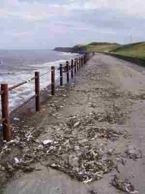
Sewage pollution at Hendon Promenade, June 2007
The combined sewage outfall (CSO) at Hendon, south of Sunderland, Tyne and Wear, is producing persistent discharges of raw sewage which is contaminating the sea and coastline. MARINET member, Robert Latimer, and CASSS (Campaign Against Sewage in the Sea at Sunderland), believe that the problem is due to insufficient treatment capacity at the Hendon Sewage Treatment Works and that this pollution is occurring not just during periods of rainfall but under dry weather conditions as well. Criticism is being levelled at the local Environmental Agency and Ofwat for failing to require Northumbrian Water to remedy this lack of sewage treatment capacity and consequential pollution.
Beach recharge at Bournemouth goes seriously wrong
A beach recharge project (the replenishment of a beach with imported sand) at Bournemouth has gone badly wrong and resulted in the loss of the sandy character of Bournemouth's award-winning beach. The new sand has been washed away, leaving behind a beach of sharp flint and shingle. The cost of remedying the problem is estimated at £164,000. For further details see www.24dash.com/localgovernment/22609.htm
Details from the local paper can be seen on the pages of the Bournemouth Echo, 20th June 2007
Surfers foresee surfing threat from Global Warming
The UK surfing group, SAS (Surfers Against Sewage), has issued a report which analyses the potential long-term effects of global warming on their sport in the United Kingdom. Over 600,000 people now surf in the UK and SAS are asking their members to adopt a greener lifestyle and thus reduce their carbon footprint. For further details, see the SAS report at www.sas.org.uk or www.globalsurfnews.com/news.asp?Id_news=28555
Fisheries impacting adversely on dolphins off Devon and Cornwall
A new report by Marine Connection, a charity involved in the protection of cetaceans (whales, dolphins and porpoises), and The Wildlife Trusts, has shown a dramatic increase in the number of dead dolphins being washed ashore onto the coasts of Devon and Cornwall. Many are the victims of entanglement in fishing gear and, if this trend continues, this may have serious implications for dolphin and other cetacean populations. Some 28 species of whale, dolphin and porpoise use the seas around the UK as their home, and the new report collects evidence about these populations and makes recommendations on research, legislation and improved fisheries management measures. A copy of the report can be obtained by visiting www.marineconnection.org and www.wildlifetrusts.org
EU report says Europe's seas are being "ruined"
European scientists, based at the Marine Insitute at Plymouth University have produced an EU funded report, titled "European Lifestyles and Marine Ecosystems", which predicts dire consequences for the future of European seas, including the NE Atlantic, unless they are better protected. The EU study has considered habitat change, eutrophication (over-fertilisation of the sea), chemical pollution and fishing, and has found severe problems in four seas - the NE Atlantic, the Baltic Sea, the Black Sea and the Adriatic in the Mediterranean. In the case of the NE Atlantic the severest problems are caused by pollution and over-fishing. Professor Laurence Mee, Director of the Plymouth Marine Insitute, has said "In every sea we found serious damage related to the accelerated pace of coastal development, the way we transport our goods and the way we produce our food on land as well as the sea. Without a concerted effort to integrate protection of the sea into Europe's development plans, its biodiversity and resources will be lost."
For further details, see Cordis News 11th June 2007
Coal Authority to pump minewater into sea
From an article by Fiona Thompson in the Seaham Star, 31st May 2007
The Coal Authority, which is responsible for dis-used mines, is planning to start work on a £2.5 million project to pump polluted minewater at Dawdon, near Seaham in Co. Durham, into the sea via a pipeline. Concern is being expressed locally by the Seaham Environmental Association and others that this pipeline, around 70 metres long and discharging at a rate of 100 litres per second, will be too short to allow for adequate dispersion of the polluted minewater and that, consequently, the marine ecology of the area will be adversely affected.
Downing Street petition calls for cessation of marine aggregate dredging
An article in the Eastern Evening News, 14th June 2007, asks the question: Is dredging ruining our coastline? The article reports on a Downing Street Petition organised by Pat Gowen, MARINET and North Sea Action Group, which calls for an immediate cessation to aggregate dredging at sea.
Fears have been raised that wide-spread dredging off the Norfolk coast could be doing irreparable damage to our coastline.
A group of environmental organisations have launched a petition on the Downing Street website to call for the digging up of sand and gravel off the Norfolk coast to be stopped, claiming it poses a serious threat.
But the extraction companies who operate in the area have rejected the claims, saying there is no evidence their operations are doing any harm.
The petition has been submitted by the Friends of the Earth's marine conservation branch Marinet and the North Sea Action Group. Pat Gowen, from Marinet, said: "There are a mass of people out in Norfolk who are opposed to this dredging and there is a tremendous battle raging about this.
"In the Great Yarmouth area there is no doubt that the huge level of commercial offshore dredging has damaged the coast. When gravel extraction takes place trenches are dug in the sea bed between one and ten kms off the coast. The sea then fills these in over time by taking material from the land".
Environment campaigners claim that on the Norfolk coast this means on-going erosion of the cliffs is being exacerbated. They claim this is especially apparent at places such as Happisburgh, where the cliffs are eroding, putting people's properties at risk and Hemsby, where all but one of the sand dunes have now disappeared.
Mr Gowen added: "Extracting deepens the sea bed by four to five meters in places. Because of that more has to come from the land to fill the trenches, this includes the soft cliffs and the beaches."
The petition calls for "commercial exploitation" of sand and gravel from the sea bed to be halted. It says: "The huge scale commercial dredging of sand and shingle from the UK sea bed for use in the construction industry and for export is damaging our marine eco-system, destroying fish stocks and causing serious erosion to the East Anglian and other coastlines."
Mark Russell, director of the British Aggregate Producers Association, which represents the dredging companies said: "The claims that are being made are not new. Research has been carried out and that has helped inform the policies that are in place to protect the environment.
"Our regulator would not allow any dredging to take place if they believed it was having an adverse effect on the environment."
To sign the petition go to http://petitions.pm.gov.uk/MarineDredging
Is Aggregate Dredging affecting the Severn Estuary?
Over 2 million tonnes of sand is being extracted annually from a possible six aggregate dredging sites in the Severn Estuary, and a Working Group has been set up to establish whether this is impacting on beaches and coastal processes. These studies are being conducted estuary-wide. See the report below from Severn Estuary Forum's Newsletter.
New Severn Estuary Aggregates Working Group
The extraction of sand from the Severn Estuary has been going on for many decades and is regulated by The Crown Estate. To compensate for the decline in the sand resource at some dredge areas and to meet projected future demand, the marine aggregate industry has sought to increase the take from other existing licensed areas and to establish new extraction areas within the estuary.
At present there are 6 existing or proposed dredging areas, from which a combined volume of over 2 million tonnes a year could be extracted. Dredging applications have been submitted for areas in fairly close proximity to each other and the foreshore. This has led to a need to determine how the removal of sand will affect coastal processes and the foreshore - because of the international designated features and importance of sea defences. This is no simple task!
Work on individual impact assessments is being undertaken. However, in an attempt to look at the issue on a more regional basis, The Crown Estate has encouraged the principal stakeholders to contribute to the newly created Severn Estuary Aggregates Working Group. One of the major features of the discussions has been that all of the dredging companies have agreed to work together to conduct detailed estuary-wide studies.
The first phase of work began in Autumn 2006, the results of which will determine the type and extent of future studies.
For further information, please contact: Rhys Morgan, Severn Estuary Officer, Environment Agency Wales.
Email: rhys.morgan@environment-agency.wales.gov.uk
Tel: 02920-245200
Dredging fears along vanishing coastline - Dredging Area 102
From The Yorkshire Post 11th June '07, an article by Alexandra Wood.
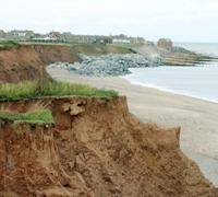
PARTS of Yorkshire's rapidly-diminishing coast could be in danger of increased erosion as a result of controversial plans to dredge millions of tonnes of sand and gravel a few miles out to sea. Campaigners say the scheme could have grave implications for what is already one of Europe's most rapidly-eroding coastlines where more than 70 homes are predicted to fall into the sea in the next 50 years. They also fear for the impact on sea life in one of the most productive shellfishing areas in the UK.
Marine aggregates company Cemex UK Marine wants to extract a maximum of 660,000 tonnes a year, up to 5m tonnes over a 15-year period from both Humber Extension and New Sand Hole, extensions of areas which are already dredged.
The larger area - New Sand Hole - is just 5.5miles off Spurn Head and the Humber Estuary, which are both protected by international law.
Cemex says there is no evidence of any coastal erosion impact due to dredging. But its own environmental impact assessment scoping report, published last year, listed concerns about dredging at New Sand Hole causing coastal erosion at Spurn Point and along the Holderness coast as a "key potential impact".
Sand and gravel dredged from the seabed supply the UK's construction industry. But more than 30 per cent is exported to countries including Holland - which does not allow dredging within 15 miles of its shoreline.
The company is preparing an environmental impact assessment report (EIA), but the EIA scoping report highlighted a range of concerns, in an area "currently subject to one of the highest levels of offshore development and activity of any area of UK waters".
ABP Humber Estuary Services feared "potential increased erosion on (the) seaward coastline of Spurn Head and Holderness Coast".
East Riding Council and Hornsea Town Council were also concerned about the effect on the rate of erosion.
North Eastern Sea Fisheries Committee was worried about loss of habitat, and "displacement and mortality of fish and shellfish populations".
Even Defra's marine environment branch was concerned about the "impact on the exposure of different substrates and the implications for local water circulation resulting from the removal or creation of topographic features on the seabed".
As revealed by the Yorkshire Post earlier this year the current rate of erosion - around two metres a year - could mean another 70 more homes lost to the sea. In 2005 to 2006 3.5m tonnes of aggregates were dredged in the Humber area.
Residents who have seen beaches depleted of sand which would normally provide a buffer in front of the mud cliffs lining the Holderness coast believe they are witnessing the impact of dredging, which has gone on for many years.
Gavin Scott, who lives at Holmpton, said between 5ft and 20ft of sand had disappeared off beaches between Kilnsea and Fraisthorpe. "The Government would have us believe that the vastly increased coastal erosion in our area is due to global warming, climate change and a rise in the height of sea levels," said Mr Scott. "But after sifting through all the evidence I personally think dredging in UK waters should now be totally banned. I think this issue is mismanagement of Crown Estates on a grand scale. It displays a total disregard for other people and their livelihoods and seems to me to be tantamount to persecution of coastal dwellers."
Fisherman Derek Crook - whose home at Tunstall has been lost to coastal erosion - said: "It is an absolute national scandal that the Government is selling sand and gravel to the Continent and it must be a contributing factor to beach draw-down."
Campaigners point out that dredging is a good earner for the Government. They say for every tonne dredged between 40p and 50p goes in royalties to the Crown Estate, which owns the seabed, and the Government charges 17.5 per cent VAT on top of the £25 to £30 per tonne the aggregates make.
Cemex said there was "no evidence of any coastal erosion impact due to dredging" and it was "a natural phenomenon".
And it said it carried out detailed studies to ensure that dredging did not affect coastal processes. "A conservative approach exaggerates the dredging and consequently over-estimates the possible impact. In addition, monitoring of the seabed and adjacent coast in sensitive areas is also undertaken while dredging is carried out," it added.
People would have further opportunity to comment when the full environmental impact assessment is published.
The Marine Fisheries Agency will make the final decision on the granting of a licence. A Defra spokesman said: "We take responsibility for the marine environment and its hinterland very seriously."
UK marine life in crisis, wildlife charity warns
From The Yorkshire Post of 18th January 2005, an article by Mark Branagan
Athough a little outdated this article is very topical.
BRITAIN'S seas are being "exploited to death", according to a report out yesterday that claims 13 out of 16 flagship marine species studied by scientists are in decline. But the findings attracted an immediate broadside from a Yorkshire fishing leader, who accused the World Wildlife Fund of juggling already discredited Government statistics.
The WWF report brought out yesterday at Scarborough Sea Life Centre claimed species facing extinction include the leatherback turtle, the native oyster and the anemone-like pink sea fan. The new study claims marine life as diverse as prawns and sharks are suffering from the combined effects of fishing, sand and gravel dredging, oil and gas exploration and other human activity. Basking sharks are being run down by ships in the English Channel while deep-water mud habitats found in sea lochs are being exploited to put scampi on our plates.
Five years ago WWF's first Marine Health Check warned of the potential threats to marine wildlife, such as sand and gravel extraction of pristine areas of the seabed. Jan Brown, WWF senior marine policy officer, said: "This report clearly shows that five years on the plight of the UK's seas has worsened. Our marine heritage is in a shameful state for a maritime nation. To most people, our marine environment is out of sight and out of mind, so its demise is hidden. However, it is not just wildlife that is suffering from poor management of our seas. Some coastal towns and villages in many parts of the UK that once thrived on the riches of the seas are now degenerated."
The report says the common skate is so scarce recent surveys to assess their status failed to find a single one. Horse mussel beds create a habitat for about 100 other species, but they are being destroyed by scallop dredging, the findings say.
Surveys carried out in Strangford Loch, Northern Ireland, indicated a large 3.7 square kilometre loss of these beds since 1993.
Deep-water mud habitats in sea lochs are heavily targeted for scampi. Although since 2000 specific areas such as Loch Torridon have received increased protection, others continue to be trawled. Trawling and dredging are also blamed for a severe decline in the beautiful fan mussels, which remain undisturbed in only a few parts of the UK. Dredging for scallops is also damaging maerl beds, which are made up of calcified seaweed and provide an important nursery ground for species essential to commercial fishing.
The pink sea fan coral, Eunicella verrucosa, is declining in the unlikely setting of England's only natural marine reserve, off the coast of the island of Lundy in the Bristol Channel. Legislation has been developed on a sector-by-sector basis, which has resulted in a piecemeal approach.
Jan Brown continued: "WWF believes that a UK Marine Act is the only real solution to the crisis in our seas." But Scarborough Inshore Fishing Society chairman Fred Normandale said the real threat to coastal economies was from organisations such as the WWF and their reports. He added: "My number one argument is where do they get their statistics from? Every one of these pressure groups gets their statistics from the Government. We have proved over and over again that the Government statistics are way out. I have been on their research vessels and pointed out the gear they are using won't catch fish."
Half the UK fleet has already been docommissioned and the industry is being regulated as never before in terms of days at sea and mesh sizes, he added.
Serious weaknesses in UK Marine Bill White Paper
Whilst MARINET welcomes the UK Government's White Paper's proposals to strengthen the management of UK seas, in particular the new marine planning and licensing regime located in a new dedicated agency - the Marine Management Organisation - we believe that the proposed Bill has many serious weaknesses and is in danger of failing to deliver a truly sustainble future for our seas. Specifically, we believe that the Bill fails to understand that marine nature conservation and a management regime based on marine reserves is the way in which to restore long-term economic sustainability to our seas; and, that a Bill which fails to tackle damaging and unsustainable fishing practices throughout the whole UK fishing area is a huge missed opportunity and a serious failure of political will. To address these issues, MARINET has told the UK Government that it must create a Ministry of the Sea which will provide political leadership and clearly located responsibility, and that the Government must codify in the Bill a clear statement of the ecosystem-based approach to marine management so that the principles for delivering and restoring long-term health to our seas are clearly stated, widely understood and legally enforceable.
Full details of MARINET's proposals can be seen at www.marinet.org.uk/marinebill/whitepaper.pdf (pdf file).
UK Government's proposals for a Marine Bill
The UK Government has come forward with a series of proposals in a White Paper on marine planning and licensing, marine nature conservation and inshore fisheries with regard to the management of UK seas, extending from coastal high water mark out to 200 nautical miles. These proposals include a new planning system for the use of the sea's natural resources, the licensing of the use of those resources, and a new executive agency - the Marine Management Organisation - which will administer the new planning and licensing regime. The Government also has proposals for the nature conservation principles governing our seas, including the creation of Marine Conservation Zones, and has proposals for an ecosystem-based approach to the management of UK inshore fisheries out to 6 nautical miles. The full range of proposals are set out in a White Paper for a Marine Bill which may be viewed at the Defra website (pdf file).
A summary of the UK Government's proposals on marine planning and licensing, marine nature conservation, fisheries and the new Marine Management Organisation may be seen in the MARINET submission to the White Paper public consultation, see: www.marinet.org.uk/marinebill/whitepaper.pdf (pdf file)
£35 million sea defence approval
From the Scarborough Evening News of Friday 25th May comes this story by Sophie Barley of sea defence funding.
PLANS for new sea defences around Scarborough, which could cost up to £35 million, have been given the go-ahead.
Scarborough Council's cabinet approved plans to boost the sea defences between the Sea Life Centre, the Spa Chalet, the Spa and South Cliff Garden areas of Scarborough. The plans will now have to go to the full council for a final decision on July 9th.
A review of the coastal defences between Holbeck and Scalby Mills has been carried out because of the age of some of the structures. A number of them are more than 100 years old and are on need of major improvement. The work will be carried out over a five-year period from 2009 and include using rock armour.
Likely nuclear sites need flood defences
From Reuters and The Scotsman of Thursday 24th May 2007 comes this story of the growing threat to the nuclear power stations.

A file photo of a fisherman walking past the Dungeness nuclear power station in Kent, England. The prime sites for nuclear power plants the government is keen to see built are on the southern coasts, where the flood risk is higher than elsewhere in the country, a government-commissioned report said REUTERS/Toby Melville
The prime sites for nuclear power plants the government is keen to see built are on the southern coasts, where the flood risk is higher than elsewhere in the country, a government-commissioned report said. The report by energy analysts Jackson Consulting for the Department of Trade and Industry identified Hinkley Point, together with Sizewell and Dungeness, as the best sites for large nuclear power stations.
But it warned that any company planning to build there would probably have to bolster existing flood defences against sea level rises as the effects of climate change take hold. "There remains a drawback that most nuclear power stations are sited in low lying coastal locations, which may be at risk from coastal erosion and serious flooding as a result of climate change," the report, released along with the government's nuclear energy consultation, says.
"For new nuclear build, consideration would need to be given to flood protection over the expected 100-year lifecycle of the power station, spanning construction, operation and final decommissioning. This would need to take into account predicted sea level rise including credible extreme weather scenarios and events."
The government aired an energy policy overhaul on Wednesday, aimed at cutting emissions of greenhouse gas carbon dioxide -- through support of nuclear and renewable technologies -- while trying to improve energy efficiency. Officials are still consulting on whether to allow a new fleet of nuclear power reactors, but the government made clear it sees atomic energy as a key tool in reducing emissions and boosting security of supply.
Apart from safety concerns, environmental groups say the huge costs involved in building and later decommissioning nuclear power plants would be better spent on cleaner and safer forms of power production like wind and wave power. Industry leaders and the energy sector argue that a looming gap in power generation must be filled with more than just gas-fired and renewable power plants.
Jackson Consulting points to a 2005 report by radioactive waste agency Nirex warning that many coastal nuclear sites are vulnerable to the effects of sea level rise from climate change, particularly storm surges. Nirex also said those sites at most risk are generally located in low lying parts of southern England, where forecast energy demand is highest.
INCREASED COST
The report, released along with Wednesday's energy white paper, says the need to adapt current sites to the impacts of climate change does not rule out new nuclear build in coastal locations, but warns that it will probably increase the already large capital cost of constructing them. If the government does decide to allow companies to build a new wave of reactors, it would be up to the private sector to propose what sites they want to use, a DTI spokesman said.
Only nine of the country's 19 existing nuclear power stations are suitable for building a new generation of nuclear power plants, the report says. So the government may have to look inland at older civil nuclear sites and military installations if it embarks on a large plant building plan, using huge, unsightly concrete cooling towers and river water instead of sea water to keep the plants cool. Experience in France shows river-cooled nuclear plants sometimes have to close as they cannot run safely in heatwaves.
Other possible sites identified by the report include existing coal and gas fired power stations, which already have connections to the electricity grid, a key factor in determining site suitability.
Environmental groups protest at sewage plant
Eastern Daily Press 14th May '07
Outraged environmental groups last night voiced their strong opposition to plans to pump minimally-treated sewage into the sea off the north Suffolk coast. They claim the application by Anglian Water (AW) for permission to temporarily reduce the amount of treatment it carries out at its Lowestoft Waste Water Treatment Centre is in breach of European law and have fired off an email to officials in Brussels.
The opposition from the North Sea Action Group (NSAG) and the Marine Environmental Information Network (Marinet), emerged after AW announced a £1.5m maintenance and improvement programme at the plant in Corton, near Lowestoft.
If the plans get the go-ahead from the Environment Agency (EA), work will take place between October and April and sewage will only receive minimal screening before it is pumped out to sea. AW insists the procedure is safe because it is taking place outside the summer season and a spokesman for the EA said the European Union bathing water directives did not apply between October and April.
But Pat Gowen, who represents both the NSAG and Marinet, said he had huge concerns about the plans and their impact. In a letter to the EA, Mr Gowen said: "Lowestoft is a bathing beach in regular daily use by many bathers, both in the summer bathing season and in the winter, also supporting other sea recreational activities such as surfing and jet-skiing. The health, welfare and well-being of these people would thus be jeopardised by a removal of required treatment. Further, the marine environment in this area is sensitive and likely to be further damaged by reversion to such a polluting discharge."
The £70m waste treatment centre was opened at Corton in 2001 and is fully enclosed to prevent smells blighting local residents' lives. However, its design means corrosive gases have damaged equipment a lot quicker than expected. AW is to bring back into use an old pipe, which extends out to sea by about a mile, to ensure a safer dispersal of sewage water at Ness Point in Lowestoft. The proposals are currently going through a public consultation period, after which the EA will make its decision.
John Daniels, a regulatory specialist for the EA, said: "If we allow AW to go ahead with this work, it will take place outside the bathing season. The bathing water directive doesn't apply between October and April."
The water pumped out by waste treatment centres has been subjected to far tighter restrictions in recent years, but Mr Daniels added that temporary consent to discharge less treated sewage into the sea could be granted by the EA.
AW spokesman Dan Baker said the company was satisfied the work would be safe and would be happy to respond to concerns raised during the public consultation.
Anyone wanting to comment on the proposals should write, by June 15, to the Area Planning and Corporate Services Manager, Environment Agency at Iceni House, Cobham Road, Ipswich, IP3 9JD, quoting ASECS/12405B.
Great Yarmouth Fisherman's Revelations
Testifying at a meeting of MARINET and the Great Yarmouth Probus held at Great Yarmouth on 18th April 2007, John Wells, member of Coastwatch and a fishermen of the area, told how once the fishermen would go out accompanying the dredgers. The invitation resulted from the local fishermen's complaints made at meetings with DEFRA, MAFF and the dredgers, where they expressed concern at dredging the herring spawning grounds and the huge numbers of fry (immature plaice, sole, dabs, etc.) that were being captured with the sand and gravel.
As the dredgers vehemently denied this, it was agreed that some of the fishermen should accompany the dredging operations so as to monitor and evidence that this did not occur in practice. But the precise opposite resulted, as they soon found on close inspection of the catch that the content of small fish in the take was enormous. When the fishermen presented this evidence, pointing out that if they had captured and landed such, they would undoubtedly receive a hefty fine, they were then debarred from the missions on grounds of the friction that resulted with BMAPA.
John Wells also testified how the Scroby sand bank had depleted seriously since 1973, with a half mile stretch suddenly lost that year and a further three quarters of a mile of the easterly end disappearing between 1974 and 1975. He pointed out that it was the firm opinion of both the fishermen and the offshore wind turbine operators that dredging to the immediate east had brought about instability of the turbine bases, as a 5 degree tilt of the masts of the northernmost four had resulted, bringing about damage to the turbine gears due to the eccentricity produced.
Earthwatch Lecture: Managing the Marine Environment
7.00pm, Wednesday 6th June, at the Royal Geographical Society, 1 Kensington Gore, London SW7
Speakers: Dr. David Smith, Coral Reef Research Unit, University of Essex & Dr. Marcos Santos, Universidade de Sao Paulo
Two talks about Earthwatch research into vulnerable marine ecosystems, one on the threats posed to Seychelles coral reefs, the other on Brazil's lesser known dolphins, particularly impacted by tourism. Free, but ticket only.
For tickets & more information, please contact Earthwatch on 01865-318856; events@earthwatch.org.uk
www.earthwatch.org/europe/events.html
Letter of objection sent to the Environment Agency
Sent by Pat Gowen in response to Anglia Water's plan to pump 'raw' sewage into the sea off Lowestoft
To: Area Planning & Corporate Services Manager, Environment Agency, Iceni House, Cobham Road, IPSWICH, Suffolk IP3 9JD
Ref: A56CS12045B
Dear Sir,
My organisations, MARINET, the Marine Environmental Information Network and NSAG, the North Sea Action Group, wish to object in the strongest possible terms to the proposal to discharge untreated sewage effluent into the marine environment of the North Sea from the Sewage Treatment works at Ness Point, Lowestoft, as advertised by the Press Notice in the 'Eastern Daily Press' of 5th May '07.
Such an action would clearly be an offence under the rulings of the Urban Waste Water Directive UWWD 91/271/EEC which is now in force for all major marine sewage discharges, i.e. outfalls to the sea. The 91/271/EEC Directive stipulated that as from 31st December 2000, in order to protect public health and the environment, no sewage sludge must enter the water, i.e. sewage must have primary treatment to remove the solids, secondary treatment as a minimum (aeration to further destroy pathogens to reduce the bacterial and vital concentration) and tertiary treatment (UV irradiation and/or nutrient stripping) must be provided in environmentally sensitive areas, which includes bathing beaches.
The 'primary treatment' claimed for the Lowestoft Ness outfall is not treatment as such, but is in fact 'preliminary treatment', which only serves to reduce the visibility of the content by screening through an 8mm mesh, so disguising the presence of excreta. Primary Treatment is settlement or filtration removal of all solids, which are the main carriers of the viral pathogens. For detail of sewage treatment please go to: www.marinet.org.uk/ukbw/sewage.html
Although none of East Anglia's beaches have been proved to comply with the mandatory standard of the 1975 76/160/EEC Bathing Waters Directive, there is little doubt but that the multiple stages of treatment provided since the UWWD came into force to meet the deadline of 31st December 2000 have proved effective, as the faecal coliform levels have dropped considerably since then. It would be a retrograde step to now aid and abet the return of the previous highly polluting levels that existed when the sewage effluent was discharged with only disguising screening as proposed.
The UK Government also appeared to support meeting the deadline of 31st December 2000, as a 19th October 1999 letter to James Gray MP from Chris Mullin, Under Secretary of State for the Environment, identified the Government's objective, that:-
"... secondary treatment should be installed as soon as possible for all significant coastal sewage discharges ... and whenever possible to meet the initial deadlines set by Article 4 of the Directive".
A list of the relevant discharges and the completion dates for each outfall was attached that showed that many would not meet the deadline of 31st December 2000. Included among these was Lowestoft, which was stated not to reach full treatment until 31st December 2001. This postponement was agreed between the DETR, the EA, OFWAT and the Water Companies, but NOT by the EC. No derogations were permitted. Consequently the North Sea Action Group (NSAG) wrote with concern to DG-XI, legal wing of the environmental branch of the EC, in January 2001, complaining of the attempted delay in meeting the Directive.
Sybille Gross of DG-XI responded saying "With regard to the failure of the UK to meet the Urban Waste Water Directive (UWWD), we have already made clear to the UK that we do not share their opinion that the withdrawal of HNDA" [High Natural Dispersion Areas, areas of the sea where the UK claimed that secondary treatment would occur naturally] "status allows an extension of the deadline. In any case, any further information you have on this to feed in would of course be welcome, especially where this information can link outfalls to particular agglomerations of the size relevant to the 2000 deadline. If you have this sort of information and wish to send it in as a formal complaint then let me know."
In view of the failure of the UK to meet the treatment deadline required by the UWWD and the consequence in subjecting people to pathogen polluted bathing resorts for yet another summer holiday season, the NSAG made a formal complaint to DG-XI of the EC. The Commission responded on 3rd May 2001, writing:-
"Concerning Directive 91/271/EEC on urban waste water treatment, I should inform you that we have just last month issued a reasoned opinion to the UK Government for their failure to fully respect this Directive. The reasoned opinion concerns that failure to designate sufficient sensitive areas (in particular, areas which are actually or potentially eutrophic and bathing waters) and the failure to meet the collection and treatment deadline of December 1988 for a number of agglomerations. We are currently assessing compliance with the December 2000 deadline for all Member States and will decide whether further action is needed once this assessment is complete. No derogations have been granted to the UK."
As a consequence of our formal complaint our Government faced the threat of European legal action which could result in considerable fines due to the European Commission taking Britain to the European Court of Justice, accusing the UK for failing to correctly treat waste water discharged, because Britain has failed to introduce rules agreed at EU level into national legislation. Environment Commissioner Stavros Dimas stated:-
"EU environmental legislation has already done a lot to improve the state of the environment in the UK and elsewhere in Europe. But to be fully effective, it must be fully implemented."
Environment Commissioner Stavros Dimas stated:
"By not fully complying with this EU law, the UK is not delivering the level of protection against pollution from waste water that it signed up to and that British citizens deserve, I intend to give priority to ensuring that Member States live up to their commitments."
As a consequence the European Commission issued the United Kingdom with a final warning due to its failure to apply the demanded regulations on sewage treatment.
We have to tell you that if alternative arrangements to treat this sewage are not made and that this application to break European and National Environmental law by the reintroduction of untreated to the marine environment at Lowestoft is permitted, we shall face no alternative other than to take this matter to DG-XI.
Lowestoft is a bathing beach in regular daily use by many bathers, both in the summer bathing season and in the winter, also supporting other sea recreational activities such as surfing, wind surfing and jet-skiing. The health and welfare and wellbeing of these recreationalists and the town populace would thus be jeopardised by a removal of required treatment. Further, the marine environment in this area is sensitive and likely to be further damaged by reversion to such a polluting discharge.
We thus additionally regard such an action to support a reversion to a polluting discharge to be a human rights, health and social issue, and correspondingly ask that permission is refused and that temporary alternative methods of the legally required sewage treatment, e.g. transport or piping to a sewage treatment works are provided until the work is complete.
We would be grateful for an early indication of your decision.
Pat Gowen, NSAG & MARINET
Lowestoft Sewage Treatment Works to temporarily pump raw sewage to sea
Anglia Water has announced that it will be reopening the long sea outfall for its Lowestoft Sewage Treatment Works and pumping out sewage to sea with only preliminary treatment, i.e. essentially raw sewage, from October 2007 to April 2008 whilst it undertakes essential repairs to the sewage works. Anglia Water claim that the pollution caused will be within acceptable levels.
For full details, see the EDP of 4th May 07.
Fears over Lowestoft seafront erosion
From the pages of the Eastern Daily Press of 1st May comes the story of further erosion of our East Anglian beaches.
Emergency action has been taken to protect an area of Lowestoft seafront after the beach was eroded so badly that the ruins of a previous sea wall were exposed. At one section, next to School Road in the North Denes area, it emerged that slabs were being held up only by debris, creating a dangerous void.
A 30-tonne excavator, with a hydraulic breaker, was brought in to split the slabs and drop them flush on to the beach without the need to remove material from the site. Meanwhile, a section of beach in the area will remain closed to the public until beach levels have risen again.
In January, the EDP reported how severe and persistent winds had left many of Waveney's sea defences under threat, with sand levels becoming dangerously low.
Martin Plane, Waveney District Council's portfolio manager for the built environment, said: "We moved quickly to ensure public safety, given that the need to protect the general public will always be our overriding priority. Similar work is planned during May along the frontage south of this point. However, it is hoped this will be completed with smaller plant."
Mr Plane reminded people that North Denes beach, south of Swimming Pool Road, was closed for now because of the dangers posed by debris from the old wall.
Huts tower over Felixstowe's beach
From Suffolk's 'Evening Star' of 27th April '07 comes this story of the continuing erosion of Felixtowes beach.
MOST town's have high-rises that tower over the landscape - but Felixstowe's loom over the beach. For these are the resort's high-rise beach huts, now left dangling up to nine feet over the sand and shingle because of the dramatic erosion over the past two decades. But their precarious position with the constant threat of the sea sweeping them away has not devalued them - and one has just sold for £17,000, the most ever for a hut at the resort.
Owners, though, do not know how many years they will be able to keep the chalets hanging over the East Beach in Undercliff Road East. For safety reasons, they all have balconies, and most of the flights of steps have had to be extended. Some extended stairways still hover a foot or more from the sand.
Adrian Miller, who has owned his beach hut for 20 years, said the piles on the wooden frame on which it sits go down two metres into the beach. In the winter months, the huts are moved back onto the prom. Mr Miller said: "When we first had this hut, it sat on the beach and you stepped straight out onto the sand - no steps, no balcony, just straight onto the shore. The beach then went 30 yards straight into the sea. Now we have these huge drops and big flights of steps and the high tide line comes right up to the bottom of the steps. Something needs to be done."
Neighbour Basil Smith, of Western Avenue, said he could remember when the groynes next to the huts were covered by 18 inches of shingle. Now the concrete breakwaters stand three feet tall and the beach is being scoured from underneath them. "If the council hadn't put the rocks next to the groynes, I don't think the huts would have lasted this last winter," he said.
Mr Miller, of Ranelagh Road, Felixstowe, said despite the state of the beach, he had been offered £20,000 cash for his hut by a visitor from London last summer. "I wouldn't sell - it's a part of our family history. My daughter grew up here, playing on the beach, and now she brings her daughter here - it means a lot to us and we love it here," he said.
Suffolk Coastal is monitoring the coast in case further emergency action is needed. Consultants have also been looking at the stretch to see what extra action might be taken coupled with beach replenishment.
What do you think of the state of the beach? Write to Your Letters, Evening Star, 30 Lower Brook Street, Ipswich, IP4 1AN, or e-mail EveningStarLetters@eveningstar.co.uk
Offshore wind - two new major projects in the Thames Estuary
Trade and Industry Secretary Alistair Darling has given approval for two major offshore wind farms in the Thames Estuary. The first, the £1.5bn London Array, would be the world's largest. When it is completed in about 2011, it will consist of 341 turbines over 144 sq miles (232 sq km), 12 miles offshore between Margate in Kent and Clacton, Essex. The first turbine is likely to be installed in 2008. It is being built by a consortium involving Shell Wind Energy, Eon UK and CORE.
The other project, Warwick Energy's £500m Thanet scheme, will consist of 100 turbines 7 miles off North Foreland, Kent, covering an area of 21 sq miles.
It is claimed that the windfarms combined will be enough to power a third of London's three million households, or the combined households of Kent and Sussex.
A report about these two new projects in the Thames Estuary may be viewed at the Open University Renewable Energy magazine's website http://eeru.open.ac.uk/natta/renewonline/rol66/2.htm
FOE Cymru says no to Severn Barrage
Friends of the Earth Cymru has produced a report which details the reasons why a Severn Barrage should not be built in order to produce electricity. Principal amongst the reasons against is the argument that other sources of renewable energy are more efficient and benign and that a massive construction project like the Severn Barrage would deny these other renewable energy sources of essential financial capital at a key time in their development. A digest of the FOE Cymru report may be viewed at the Open University Renewable Energy magazine's website http://eeru.open.ac.uk/natta/renewonline/rol66/6.htm
The UK Government issues a White Paper for its proposed Marine Bill
The UK Government has published its White Paper which provides an outline of the proposals for a Marine Bill. This Bill, currently in a draft form and at a public consultation stage, will create a planning system which will map the uses and resources of the sea and reform the issuing of licences for the use and extraction of those resources. It also makes proposals for increased marine nature conservation protection up to 200 nautical miles and for the reform of fishing within the UK territorial limit of six nautical miles. If you wish to comment on the proposed Marine Bill, comments must be submitted to Defra by 8th June.
For full details, see Defra's Marine Bill Newsletter.
Aggregate dredging site, Area 436, left in poor condition.
In July 2006 the UK government issued a new 5 year aggregate dredging licence for Area 202, which is known as Cross Sands and is located off Great Yarmouth. Area 202 is linked to an adjacent aggregate derdging site at Cross Sands, Area 436.
The licence to extract marine aggregate (sand and gravel) from Area 436 expired in June 2006 and the aggregate company, Hanson Aggregate Marine Ltd, applied to continue aggregate dredging in this locality via a licence extension for the adjacent site, Area 202.
MARINET has objected to this new licence extension for Area 202 because in the Environmental Statement (ES) for the new Area 202 licence it was shown that of the total amount of sediment (sand and gravel) which had been removed from the seabed in Area 436 (the adjacent site) during the previous 5 years only 20% of this loss of seabed could be accounted for by the actual removal of dredged material and, in some places, the seabed had disappeared to a depth of 5 metres. The remaining 80% loss, the ES claimed, had disappeared due to natural processes.
This high incidental loss of seabed concerns MARINET. Firstly, the actual natural processes accounting for the large loss of seabed are not clearly explained in the ES, and MARINET fears that these "natural processes" may have been induced or accelerated by the dredging activity itself. Secondly, if natural processes are working in this manner in Area 436, what are the implications for the new licence in Area 202 (the adjacent site) and the extensive wider block of aggregate dredging licences off Great Yarmouth?
MARINET asked the UK government to investigate both of these matters before deciding whether to issue a new licence for Area 202. The UK government declined to do so.
Also, MARINET has been concerned about the uncertain physical and biological condition of Area 436 upon the expiry of its licence. Government procedures which determine the issuing of licences (Marine Minerals Guidance Note 1) require the licence holder to demonstrate that at least 50 cms of natural substrate (sand and gravel) remain on the seabed when the licence expires so that there is a suitable physical habitat for marine life to use in recolonisation of the area, and the licence holder is meant to undertake a programme of monitoring to see whether this recolonisation occurs.
In the case of Area 436 the UK government has neither required the licence holder (Hanson Aggregate Marine Ltd) to demonstrate that 50 cms of substrate remains following the expiry of the licence, nor to undertake any programme of monitoring to establish whether recolonisation by the natural benthic community (marine life) occurs. MARINET has informed the UK government and the relevant Secretary of State that this, in MARINET's opinion, is a failure of duty.
For further details of these matters, see Area 202/436 on our Marine Aggregate Dredging page.
UK Government issues temporary aggregate dredging licences for Area 401/2
Hanson Aggregate Marine Ltd's aggregate dredging licence for Area 401/2, off Great Yarmouth, expired in March 2006 and the company has sought a new licence to run until 2013.
In the opinion of MARINET, the licence which expired in March 2006 has had a seriously adverse effect on the marine and coastal environment in that locality and, in MARINET's opinion, the company's Environmental Statement in support of the new licence application contained some serious weaknesses. MARINET has expressed this view to both the company and the UK government which issues the licences, but the issues at the basis of MARINET's concern remain unresolved.
In April 2006 the UK government issued a temporary licence to Hanson Aggregate Marine Ltd for nine months, and renewed this temporary licence again for a further six months in January 2007. The UK government did not inform MARINET of these temporary licence extensions, and only issued a public statement about these temporary licences in reply to a MARINET enquiry about whether a new licence until 2013 had been determined.
According to the UK government in a letter dated 6th March 2007 to MARINET, the decision on whether to grant a new licence until 2013 will be determined "shortly".
MARINET has informed the UK government that its concerns about the serious adverse environmental impact of the old licence (which expired in March 2006) still remain unresolved, and MARINET has asked the UK government whether it will discuss these concerns with MARINET before deciding whether a new long-term licence should be issued.
For further details, see Area 401/2 on our Marine Aggregate Dredging page.
New aggregate dredging licence application for Area 430 offshore from Sizewell, Suffolk
United Marine Dredging Ltd and CEMEX UK Marine Ltd are seeking a renewal of their licence to extract sand and gravel from Area 430, 15 miles offshore from the Sizewell nuclear power station, Suffolk. The existing licence expires in November 2007, and the new licence application is for another 15 years of dredging.
Concerns have been expressed recently that Sizewell nuclear power station is seriously vulnerable to flooding in the future due to coastal erosion and sea level rise caused by global warming. See our two Latest News articles on this: Erosion and Flooding threat to Nuclear Reactors and Sizewell nuclear plant could be flooded.
MARINET is currently discussing the scope of the Environmental Impact Assessment for the new licence application with the companies' consultant, Metoc plc. For further details, see Area 430 on our Marine Aggregate Dredging page.
EU Commission announces new policy on fishing by-catches
The Commission has commenced the formulation of a new policy to tackle the problem of fishing by-catch and discarding - the practice whereby fish are thrown back dead into the sea because there is no quota to permit their landing. The new policy, to be formulated during this year and next, will place the requirement on fishermen to devise the solutions to the problem. A clear statement of the by-catch and discard issue can be seen at the EU Fisheries website
How Safe are our Seaside Bathing Waters?
MARINET research reveals that the official reporting of bathing water quality at UK seaside resorts is concealing serious health risks.
See our Press Release for 4th April 2007 at www.marinet.org.uk/ukbw/pressrelease0407.html
Marine Reserves meet with success in New Zealand
See the April 2007 National Geographic article for an account of the growing success of of marine reserves in New Zealand and the aspiration of the New Zealand fishing industry to set aside 30% of their seas for protection within the 200 nautical mile Exclusive Economic Zone.
Dutch Dredging Profits, UK Losses
Our readers will delight in learning that our Dutch dredging friends have had a very good year at the expense of our coastlines' and seabeds. www.sandandgravel.com/news/article.asp?v1=9976
Boskalis describes unprecedented levels of activity - News - March 28, 2007
Dutch dredging contractor Royal Boskalis Westminster has described what it called "unprecedented heights" in the level of activity in the international dredging market, with many large projects still in the pipeline. In a recent statement, the company said it is following a policy based on a broad market spread, targeting both existing and new markets.
"This means that Boskalis is making deliberate choices about the deployment of people and equipment. This selective contracting policy also produced good results in 2006," said the company. "The high market demand is primarily a feature of the markets driven by energy and raw materials. The core activity of dredging and earthmoving, and the partners Archirodon and Lamnalco, generated a strong flow of new contracts. The selective contracting policy made it possible to take appealing opportunities in the Middle East and Australia, and to respond to new developments in Brazil, Russia, India and China," said Boskalis.
Boskalis said prospects for Europe are also favorable. Preparations are underway for a range of extensions to container ports, particularly in Germany, the United Kingdom, The Netherlands, France and Spain. "These projects are expected to generate a lot of work in the years to come," Boskalis noted.
========
Van Oord - profit more than doubled in 2006 - News - March 23, 2007
www.sandandgravel.com/news/article.asp?v1=9969
Dutch marine and dredging contractor Van Oord reports that its turnover more than doubled in 2006. "The year 2006 was an excellent year for Van Oord. Turnover grew considerably and profitability was up," said the company in a statement. In 2006 Van Oord realised a turnover of EUR 1,516 million (2005: EUR 1,002 million). Net profit of EUR 89 million was more than double that of 2005 (EUR 42 million)
"The company has been able to benefit considerably from favourable market circumstances. In addition, human resources and equipment had an almost 100 per cent utilisation and the profitability of many of projects was also up," said Van Oord.
At year end 2006 the company's order portfolio amounted to EUR 4,089 million (2005: EUR 3,564 million), of which EUR 1,250 million is work to be executed in 2007. Van Oord said the market in the Netherlands "grew slightly." Prices for dredging work recovered somewhat, although prices for marine construction and earthworks projects were still under great pressure.
As in previous years, Van Oord played an important role in the German market for maintenance dredging and the construction of container terminals. In the UK many projects were executed, such as coastal protection projects carried out under a long-term contract with the Environmental Agency. "Our subsidiary Dravo SA (in which Dragados SA in Spain also has a 50 per cent interest) was very active in Spain, Portugal and Italy," said Van Oord. "Northern and east European market, stretching from Scandinavia to Russia and including all of Eastern Europe, developed favourably."
More details about Van Oord's announcement will follow in subsequent issues of Dredging News Online.
=======
Note that the Dutch companies dredge off our UK coastline, and that the dredging in The Netherlands was mainly confined to maintaining port navigation by deepening for the ever-enlarging container ships.
Operators Commended in Marine Archaeological Awards
From the Aggregates Research site comes the following item
The British Marine Aggregate Producers Association (BMAPA) has announced special commendations for three sites operated by its member companies following their contributions to the advancement of marine archaeology and the understanding of our past. The awards arrive in the wake of a new protocol, introduced in 2005, which has guided marine aggregate dredging companies in reporting archaeological finds more effectively and go to the organisations that can make the most of the discovery. Developed in partnership with English Heritage, the protocol has helped the 800 staff amongst the sector's operating companies to identify over 80 significant finds in just one year.
Now BMAPA has awarded prizes to the site that has discovered the most interesting or significant find alongside an award for the site displaying the most professional attitude towards archaeological reporting. The awards have been judged by the Head of Maritime Archaeology within English Heritage, Ian Oxley.
The find with the most archaeological value, which will make the biggest contribution to knowledge and understanding, is the mammoth tusk discovered by staff at Purfleet Aggregates in Thurrock, Essex in February 2006. The tusk was within a cargo of marine sand and gravel dredged from a licensed area in the North Sea, 100 kilometres east of the River Humber. Dated by English Heritage's Scientific Dating section as around 44000 years old, the tusk represents one of the most northerly dated examples of mammoth remains ever recovered from an accurately known position on the seabed, and may have significant implications for understanding the distribution of the species during the last Ice Age.
The award for most professional attitude in applying the protocol throughout the year at a wharf is to be presented to Solent Aggregates Ltd, Bedhampton Quay, where the wharf staff were judged to be both efficient and enthusiastic in their application of the reporting requirements.
The award for most professional attitude in applying the protocol throughout the year at sea is to be presented to the marine aggregate dredger 'Arco Humber' operated by Hanson Aggregates Marine, whose staff had been regularly reporting small fossil fragments amongst the 8500t cargo of sand and gravel.
Chairman of BMAPA, Kevin Seaman commented 'When BMAPA started talking to English Heritage in 2000 to see what practical and useful steps could be developed, I don't think any of us could have predicted the significant progress that would be made. Seven years down the line, we have worked in partnership to produce a world-class Guidance Note followed up by a world-class Reporting Protocol for finds encountered during the production process.'
Ian Oxley, Head of Maritime Archaeology for English Heritage said 'The marine aggregate sector has effectively defined the standards for all other marine development activities to aspire to, and this is something that everyone involved in the industry can be incredibly proud of. Already, high standards have been set in the first year of the reporting protocols operation, reflecting the professionalism and enthusiasm of sea and wharf staff. The industry's challenge will be to maintain and improve their performance over the coming years.'
Erosion and Flooding threat to Nuclear Reactors
From the East Anglian Daily Times of 13th March 2007 comes this story by David Green entitled: 'Flood warning for nuclear sites'.

EAST Anglia's two nuclear sites will be a serious future flood risk and are unsuitable for new power stations, according to a study published yesterday. The study, by the Flood Hazard Research Centre at Middlesex University, suggested that the cost of defending the sites from significant sea level rises and storm surges would make them "economically unsustainable." It is the second report this year to warn of a nuclear flood risk. The Met Office forecast last month that North Sea surge levels at Sizewell could rise by 1.7 metres by the end of the century.
The new study, commissioned by the Greenpeace environment group, focussed on four existing nuclear sites - Sizewell, Bradwell, Dungeness in Kent and Hinkley Point in Somerset - considered to be the likely locations for new nuclear power stations. The four sites are, like all the UK's nuclear power stations, located on the coast because of the need for both an isolated position and a plentiful supply of cooling water. However, their location also puts them at a very real risk of flooding, according to the latest report.
Flooding of the area around Bradwell could, under one scenario examined, become not only more likely but "potentially be more severe". In another scenario the Essex site could become an island in the long-term, the report said, as the surrounding area became inundated with floodwaters. The report said the impacts at Sizewell were less clear. The coastline was considered to be vulnerable to change in the long term, with extensive coastline retreat.
This possibility would have high significance for the siting of any new nuclear reactor. With extreme sea level rise "there would be significant erosion and flooding across the region". Dr Loraine McFadden from Middlesex Flood Hazard Research Centre said: "Having undertaken this review of existing data, it is hard to escape the conclusion that the most sensible approach would be to reject all nuclear new-build within the dynamic coastal environment."
Greenpeace nuclear campaigner, Nathan Argent, said: "This report is yet another nail in the coffin for Blair's deluded nuclear policy. "With the catastrophic effect that sea level rise will wreak upon nuclear sites - not least economically - it now looks more likely that the industry faces a burial at sea. There's a real risk that any financial investment in new nuclear plants will sink without trace."
A British Energy spokesman said the company understood the importance of climate change, which is why it asked the Met Office, as leading experts in the field, to make a detailed assessment of environmental change and the possible impact on sites. He added: "The study suggested that although considerable rises in sea level are predicted by the end of the century, even in the most severe scenario a mix of measures including coastal defences, flood protection and plant design would ensure our sites are well-protected from the effects of sea level rises. British Energy is using proven techniques to manage the potential risk to all of our sites from tidal rises and storm surges, and will continue to do so when planning ahead to protect our existing infrastructure as well as any potential new nuclear build."
Conservation sites to become Marine Reserves
The Marine Bill is expected to recommend that a number of marine Special Areas of Conservation should be classified as Marine Reserves, see: Eastern Daily Press' of 13th March '07
Sandbanks to become fishing no-go zones
A reef built by worms and a ridge of sandbanks off North Norfolk could become no-go areas for sea users under a new wave of conservation measures. But any conservation clampdown would not have any major impact on the local fishing industry the government said yesterday.
Plans are due to be announced next week for seven areas off the UK shores to be turned into marine parks, under new conservation powers.
What is being hailed as the biggest change to marine law in a century is aimed to protecting important habitats such as cold water corals, and species including dolphins.
One spot earmarked for a possible offshore Special Area of Conservation are the North Norfolk sandbanks around 30km offshore. They are the best and biggest examples of offshore tidal sandbanks in UK waters. And it is also home to a reef made by tube-building ross worms - one of only four of its kind in the UK. Under the new SAC powers there could be a ban on commercial fishing, and "extractive activities" such as oil and gas wells. But Defra officials say there will also be shades of grey, with some areas getting a lighter touch level of controls, to allow activities to continue providing they were not harming what was being protected.
"We want to protect habitats, but we also want a sustainable fishing industry - so it is about striking a balance," said a spokesman.
The worm-built reef was about the size of a football pitch, though it had been bigger, said a spokesman for the government's joint nature conservation committee advisory body, which was tasked with identifying possible offshore SAC sites.
The sandbanks were home to clams, worms and some crabs, though crustaceans preferred rockier areas. The sites were a long way offshore with a limited amount of activity so any protection was unlikely to have a major impact, including on fishermen. A major consultation towards the end of the year would enable people to challenge the plans.
There are already SACs operating inside the 12-mile inshore waters limit including the Wash and north Norfolk coast. The new powers, part of the European Habitats Directive, would tackle areas from 12 to 200 miles offshore.
Tim Venes, manager of the North Norfolk Coast Partnership, said there would be fears about the area being closed off, but in his experience habitat protection did take into account the needs of the local economy too, and was "not a threat."
Other areas earmarked include the Dogger Bank, Lundy Island in the Bristol Channel and the Darwin Mounds coral reef off north west Scotland where trawling has already been banned under emergency measures.
Mr Venes added that even in areas like Lundy where there had been a total ban on fishing, it created nurseries which fed stocks to the surrounding areas.
North Norfolk MP Norman Lamb welcomed any conservation moves but said they had to be balanced with the needs of the fishing industry, and called for consultation to be through and listened to. He would be writing to the ministry to seek clarification on the local implications of the new measures and possible sites.
Sizewell nuclear plant could be flooded
EDP 13th March 2007 A report by Greenpeace has warned that rising sea levels and coastal erosion could jeopardise the safety of the Sizewell nuclear power plant.
Coastal flooding could threaten the future of the nuclear power station at Sizewell, according to a report released yesterday by environmental campaigners Greenpeace. A study commissioned by the group suggests that rising sea levels could cut off the Suffolk site from mainland Britain, making it more difficult to respond to an emergency there. But British Energy, which runs the power station, said the study was desk-based and insisted that work carried out on its behalf by the Met Office showed the site was well protected.
The Greenpeace study was carried out by scientists from the Flood Hazard Research Centre at Middlesex University and has led to calls from the group for the site to be decommissioned and cleared as soon as possible. Nathan Argent, nuclear campaigner for Greenpeace, said: "A sea level rise would flood the whole area and that would make it more difficult to respond to an emergency as well as leading to security issues," he added.
But a spokesman for British Energy said the company had confidence in the safety of Sizewell and its other sites in the future. "British Energy understands the importance of climate change which is why we asked the Met Office, as leading experts in this field, to make a detailed assessment of environmental change and the impact that may have on all of our sites," he said. "The Met Office study used its regional climate models and builds on previous work and data studies carried out at all of our power stations over a number of years. The study suggested that although considerable rises in sea level are predicted by the end of the century, even in the most severe scenario a mix of measures including coastal defences, flood protection and plant design would ensure our sites are well-protected from the effects of sea level rises."
Wave energy showing potential
See: http://news.bbc.co.uk/1/hi/technology/6410839.stm?ls
A news report from the BBC records significant potential for generating electricity from ocean waves, and features the Pelamis system currently being developed by the Scottish firm Ocean Power Delivery.
A very informative article with a 9 minute video showing the building and testing of the Pelamis system. Link top right of page. You will need broadband for this.
More homes at risk as coastline slips into sea
From 'Yorkshire Today' of 1st March '07 comes this story by Alexandra Wood to be found at where there is a photo gallery of pictures.
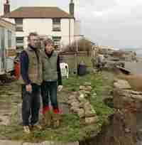
Nearly 70 more houses are under threat on the Yorkshire coast in the next 50 years, a report is expected to reveal today. As many as 67 homes - valued at £5m - could disappear due to coastal erosion.
Pressure is now growing for a national compensation fund for people whose homes are falling into the sea. Up until now, no financial aid has been available to those living on the East Coast, and residents even have to pay demolition costs themselves.
The East Coast is the fastest-eroding coastline in Western Europe, disappearing at a rate of two metres a year to the south of Hornsea. Less than six miles have sea defences. Some houses are already teetering on the edge south of Skipsea, Aldbrough and Ulrome. Campaigners say the Government should now set up a central fund benefiting both residents and coastal authorities.
East Riding councillor Jane Evison said there should be compensation to help genuine cases. A fund could help with demolition costs and also go towards helping move roads and build new defences. Coun Evison said: "It is time that Ministers started concentrating on the fact that there is an issue here that needs addressing. People should not be left without support at all."
The East Riding Council's deputy leader, Coun Jonathan Owen, added: "As we are the most highly affected in the country, as far as I am concerned this (the £5m) is a drop in the ocean for national Government compared with the goodwill they would engender by looking at compensation packages."
Beverley and Holderness MP Tory Graham Stuart said expecting people to pay to demolish homes that had fallen prey to coastal erosion was "adding insult to injury". He has written to Ian Pearson, Minister for Environment and Climate Change, asking him to encourage other coastal authorities to carry out audits, so a national picture could be built up of the impact of coastal erosion. Knowing the likely costs would make it easier to have a "constructive conversation" with the Treasury, Mr Stuart said. However, he added that 100 per cent compensation was a highly unlikely prospect because of the danger of creating "perverse incentives" for people to move into at-risk properties.
In a statement, Mr Pearson said it was "unrealistic to expect to maintain all the coastline everywhere as it is now" - but sympathised with the plight of those who expected their homes to be defended, adding: "That's why we're looking at whether other sorts of tools can be developed to help communities adapt to a changing coastline."
Brian Sweeney, who is lecturer in environmental science at Hull University, said that paying compensation could artificially inflate the price of clifftop buildings, or become a money-spinner for solicitors.
Voyage by Catamaran
This is the first part of an account of a voyage made during summer 2006 by Geoffrey Young, a MARINET affiliate member, in his catamaran, and can be read on our Regional Page under the Affiliate Members heading.
Port of Tyne : offshore dumping of contaminated dock sediments.
Bob Latimer, MARINET affiliate member, has written to Defra to establish the full details about the licence which Defra issued to permit the dumping offshore at Souter Point of contaminated dredging spoil from disused docks in the Port of Tyne, along with details about the actual operation and subsequent monitoring to ensure its safe disposal. The full text of Bob Latimer's letter to Defra is given below.
There are two earlier reports on this matter in Latest News which may be seen at
Contaminated waste dumped off Tyne estuary and
Port of Tyne - Poison in the Water
Shell Hill
Bents Rd
Whitburn
SR6 7NT
18 February 2007
Mr Andrew Dixon
Defra
Dear Mr. Dixon,
Re: Port of Tyne Dredging Trial.
To enable me to report the Port of Tyne dredging trial to the EU and to take the issue of Defra's involvement in this trial up with the Ombudsman - could you provide me, under the Environment Information Regulations with all correspondence, e-mails, notes, memos, faxes, letters and licences relating to the following questions: -
Dispersive Nature of the Site:
- Were Defra aware that the Souter Site was a dispersive site prior to the issuing of the licence? Prior to the issuing of the licence, did Cefas ever advise Defra that it was a dispersive site and did Defra ever ask Cefas if it was a dispersive site? If Defra had no knowledge that the site was a dispersive site prior to the issuing of the licence, will you please state when Cefas first informed Defra that it was a dispersive site? Also, given that it was agreed between Cefas and Defra prior to the issuing of the licence that a cap of the dumped dredge material at the dumping site would be required, does this need for a cap not imply that the dumping site had a dispersive nature? And was this foregoing logic ever explored between Defra and Cefas prior to the issuing of the licence?
- Did Defra ever discuss with the Port of Tyne and their consultants whether the Souter Site was a dispersive site prior to the issuing of the licence?
Best Practical Environmental Option:
- An Environmental Study or Environmental Impact Assessment in connection with a licence application must establish the best practical environmental option (BPEO) in connection with the licence application i.e. in this case the best disposal option (BPEO) for the contaminated dredged material. Did Defra discuss the BPEO in connection with this licence application prior to the issuing of the licence with a). Cefas, and b). The Port of Tyne and its consultants, and if so, what was the advice rendered by Cefas and the Port of Tyne and its consultants to Defra with regard to the BPEO?
Nature of Licence Issued by MCEU, Defra.
- Why have Defra constantly told me that the licence number was 3199/04/1 for this trial, when in fact this licence was replaced on 28th January 2005 by licence number 31995/05/0 shortly after the trial had begun? What are the full set of reasons why licence 3199/04/1 was replaced by 31995/05/0? At what date did Defra advise me of this change in the licence from 3199/04/1 to 31995/05/0?
- Defra has consistently told me that the conditions of licence 31995/04/1 have been met. I now find that the amount of contaminated dredge material (CDM) dumped exceeds the amount permitted in the subsequent licence, licence 31995/05/0. In other words, this condition in respect of CDM has been breached. Will Defra please explain why this specific condition regarding the amount of dumped CDM has been breached, and will Defra please state when it first became informed of this breach and by whom?
- I have recently received a copy of licence 31995/05/0. I could not see the authorisation in this licence for the amount of CDM to be dumped at the disposal site which exceeds the authorisation in licence 31995/04/1. Will you please supply a copy of the authorisation by Defra which allows disposal of the additional contaminated dredged material?
Risk Assessment of Capping.
- With respect to the extra material dumped in breach of the licence, could you please supply me with the analytical data supplied to Defra by both Cefas and the Port of Tyne and its consultants concerning the nature and quantity of the contaminants contained in this extra material dumped in breach of the licence, and the specific gravity of this extra material dumped in breach of the licence; and, any questions asked by Defra of Cefas and the Port of Tyne and its consultants with regard to this foregoing analytical data supplied to Defra?
- With respect to the capping material for the CDM, could you please supply me with the analytical data supplied to Defra by both Cefas and the Port of Tyne and its consultants regarding the specific gravity and the nature of the contamination of the capping material; and, any questions asked by Defra of Cefas and the Port of Tyne and its consultants with regard to this foregoing analytical data supplied to Defra?
- Could you please supply all evidence and analytical data provided to Defra by Cefas and the Port of Tyne and its consultants relating to the capping material which demonstrated that it was free of contamination and suited to its purpose; and, any questions asked by Defra of Cefas and the Port of Tyne and its consultants with regard to this foregoing analytical data supplied to Defra?
- Following the dumping of the CDM at the disposal site and the attendant capping operation, Cefas carried out a Risk Assessment of the capping in November 2005 and found that it was inadequate. Would Defra please supply all reports regarding the state of the capping following the meeting with the Regulator held in May 2006 and before the date of the additional capping which took place in June/July 2006?
-
Professor David Johnson of Ospar asked me to provide the following questions and he said that he would put them to Dr Vivian of Cefas at the Ospar meeting in Galway November 2006, the questions I asked were: -
- "I quote from the Cefas Risk Assessment for the PoT Dredging - 'Placement of contaminated material and subsequent capping of contaminated material in open water on this scale is almost unique, as even in the US most capping has been in shallower and more sheltered waters. This is the first in the UK and there are a number of uncertainties with regards to the potential long term effects as a result of the placement of contaminated dredged material in this area". Apart from this clear indication that this was to be Capital Dredging as Maintenance Dredging does not need capping, the assessment makes it clear that this was an uncertain and unique trial. So, how can this have been allowed to go ahead without a full EIA?"
The answer from Cefas was - "This question should be directed to Defra as they are responsible for deciding whether a full EIA is required. Cefas act as scientific advisers to Defra". Accordingly, I ask Defra to answer my question as recommended by Cefas, and would you please supply all correspondence relating to this issue and Defra's answer?
- "Defra stated to the PoT on 30.03.06' - "Defra stand by the assessment of our marine scientists at Cefas that the cap as it stands is not fit for purpose and an urgent placement of further capping material is required followed by two tier monitoring." This was one year after the trial has taken place yet the licence required that a total cap thickness was to be 1.5m, and even with additional capping in June 2006 the cap thickness is allowed to be only 0.65m. Why has this breach of the licence been allowed to continue?"
The answer from Cefas was - "This question should be directed to Defra as they are responsible for deciding whether a breach of licence has occurred?" Accordingly, I direct this question to Defra to answer and to supply all correspondence to back up their answer?
- "I quote from the Cefas Risk Assessment for the PoT Dredging - 'Placement of contaminated material and subsequent capping of contaminated material in open water on this scale is almost unique, as even in the US most capping has been in shallower and more sheltered waters. This is the first in the UK and there are a number of uncertainties with regards to the potential long term effects as a result of the placement of contaminated dredged material in this area". Apart from this clear indication that this was to be Capital Dredging as Maintenance Dredging does not need capping, the assessment makes it clear that this was an uncertain and unique trial. So, how can this have been allowed to go ahead without a full EIA?"
- You yourself informed me on the 30 August 2006 that the Souter site - "as it is a dispersive site the intention is to avoid long term accumulation of material" - Could Defra please inform me, with supporting documentation from Cefas and the Port of Tyne and its consultants about how all parties (Defra, Cefas and the Port of Tyne) intend to contain the CDM within the boundaries of the site while staying within the terms of the licence because what Defra appear to be saying goes against the spirit of what the licence requires to be achieved?
- Prior to the trial the Port of Tyne and its consultants along with Cefas put forward a specific depth regarding the required thickness of the capping. This requirement regarding the thickness of the cap was included within the conditions stated in the licence. This thickness has never been achieved. Is Defra going to allow this licence breach to continue or is Defra going to take action to ensure that that this required thickness of the cap as specified in the licence is conformed to?
- If Defra has agreed to a change in the required thickness of the cap which is less than the thickness specified in the licence, will Defra please supply all analytical data and advice rendered to Defra by Cefas and by the Port of Tyne and its consultants which demonstrates that this revised thickness of cap is safe and will not result in the dispersion of the CDM; and, any questions asked by Defra of Cefas and the Port of Tyne and its consultants with regard to this foregoing analytical data supplied to Defra in connection with the revised thickness of the cap?
-
It is my belief that Defra is allowing the Port of Tyne to breach the terms of the licence. Specifically:
- The capping has failed to reach the required thickness, and Defra has failed to enforce this requirement.
- Once the capping fell to a thickness of less than 1200mm the licence stipulates that the Port of Tyne must act to replace the capping, but Defra has failed to enforce this requirement.
- The trial took place during a period of the year when the licence stated it should not take place, but Defra has taken no action over this breach.
- The terms of the licence stated that there should be a stakeholders meeting. Defra told me meeting would take place in October 2006, but the stakeholders are still waiting for this meeting.
Accordingly, would Defra provide me with correspondence and other substantive evidence to show both the EU and Ombudsman that I am mistaken and that Defra have policed this licence correctly.
- Would Defra inform me how much of the CDM remains within the site, and would Defra supply the information which explains how and when this evaluation has been made?
- It has been brought to our attention by the EA that they received a letter from Tim Hanham of Defra dated 26 February 2004, I quote: - "about the PoT application dated 12 February 2003 for a licence to dispose of a quality of capital (i.e. material which hasn't been licensed for sea disposal before) dredgings from berths on the River Tyne to sea." Would you supply the Defra consultation letter dated 24 February 2003 and all other correspondence relating to this issue and explain why Defra informed me that the dredging was Maintenance Dredging while informing the EA it was Capital Dredging?
Please supply all of the information requested above, (even if some has already been sent) so that I can forward it the EU and the Ombudsman.
Please would you acknowledge receipt of this letter.
Yours sincerely
Bob Latimer
Scottish ministers have announced funding for what has been described as the world's biggest wave energy farm.
The Pelamis device has been tested at the European Marine Energy Centre (Emec) on Orkney by Leith-based company Ocean Power Delivery. Scottish Power wants to commission four more at the same site.
Deputy First Minister Nicol Stephen on 20 February announced a £13m funding package that will also allow a number of other marine energy devices to be tested.
Ocean Power Delivery has already exported the Pelamis for a commercial wave farm off the northern coast of Portugal last year, aimed to generate enough power for 1,500 households. At that stage the company warned that the industry could be forced to quit Scotland if there were no opportunities to use the technology closer to home. Now Scottish Power is planning a venture which it believes could create enough power for 2,000 homes.
The biggest single handout of more than £4m will go to a Scottish Power subsidiary, CRE Energy, which will build the wave farm.
Mr Stephen said: "Today marks a vital milestone in Scotland's drive to be the world leader in the development of marine renewables."
Create jobs
Of the Pelamis scheme, he said: "This will be the world's biggest commercial wave project - significantly bigger than the major Portuguese scheme.
"Scotland has the potential to generate a quarter of Europe's marine energy and kick-starting the sector is vital if we are to create a significant industry based in Scotland and meet our long-term renewables targets."
Mr Stephen said the industry had the potential to create thousands of jobs and attract millions of pounds of investment.
Scottish Power's director of renewables, Keith Anderson, said: "This is a massive step forward. It will be a test of the actual devices that will be used commercially and, if successful, should help propel Scotland into the forefront of marine energy throughout the world."
'Emerging economies'
Emec managing director Neil Kermode said: "We are delighted to see this level of support from the Scottish Executive. It sends a clear signal that the executive is determined to push forward the development of tidal and wave technologies - technologies that will unlock the enormous renewable energy potential of our coastal waters.
Increasing Erosion
Through Reuters, the National Trust placed their concern to the media that some of the country's best loved beaches and coastlines, from Golden Cap in Dorset to Formby Sands in Lancashire, in Wales and in Scotland, are under threat from erosion and flooding. They addressed the cause to be singularly due to Global Warming induced sea rise, apparently totally oblivious that along some coasts dredging activity offshore for aggregate can be a significant contributory factor.
The resulting press articles can be found here; The Guardian, The Scotsman and The Herald Tribune
Concerned at the omission and apparent non-awareness of offshore dredging as a contributory factor, MARINET has responded to each of these newspaper reports by letters to the editors.
Erosion and Beach Recharge at Dorset
From the Dorset Echo of 8th February '07 comes this story by Lynn Jackson entitled 'Fears storm surge could breach coastal defences'
 The material used to replenish Southbourne beach has also been a cause of concern
SOUTHBOURNE residents have warned of a "disaster waiting to happen" if more action isn't taken to protect Hengistbury Head from coastal erosion. A storm surge during extreme weather could force a breach through the vulnerable ancient site, they say, flooding homes and businesses in areas such as Wick, Tuckton, Christchurch, Stanpit and Mudeford.
Beach replenishment undertaken a year ago has already been washed away, say members of the Hengistbury Residents' Association (Henra). And they warn that depositing more material on the shore will be a "waste of time and money" unless the groynes are urgently improved and other coastal protection work carried out.
In a presentation to Bournemouth Borough Council's environment scrutiny and review panel, Kenneth Baldwin from Henra showed video evidence of how far the latest beach replenishment had already been eroded. He warned that the sea had breached the head and Southbourne's sea defences on at least five earlier occasions, including the entire loss of Southbourne Marine Drive during the 1950s. Henra believes the head is more vulnerable to erosion than outlined in the area's shoreline management plan, which was based on a report by coastal engineer Halcrow.
Mr Baldwin said: "Should experts outside Halcrow's organisation be correct and the head is breached, the residents and assets in Wick, Tuckton, Christchurch, Stanpit, Mudeford and other populated areas along the shores of the harbour and the banks of the Stour could well be flooded out of their homes." He added: "Although not as serious, any breach of the head will be of significant economic, environmental, archaeological and historic loss to our community."
Leslie Pickard, from Winton, an independent engineer who has worked on coastal protection in Jamaica following the devastating Hurricane Ivan, told the meeting: "It seems the groynes at Hengistbury Head have never been maintained and the rocks are too small." He added: "Putting sand back is a complete waste if you don't reinstate the controlling factors."
There were also complaints at the meeting from Southbourne councillors about the materials used for the latest beach replenishment. Cllr Basil Ratcliffe said the composition of the materials used had a higher shingle content than sand used before. "It has caused a lot of irreparable damage to Southbourne," he said. "We are very worried about the effect on business people and householders in the area."
Sheila Ryan from the Bistro on the Beach restaurant said she had received complaints from customers and visitors about the state of the beach.
Cllr Pat Lewis said: "Something has to be done to help the situation for everyone who lives and works there and for our holidaymakers."
Technological Advance in Generating Electricity from Tides
Significant developments announced in the technology for generating electricity from tides and tidal currents in the UK.
It is reported in the Jan/Feb 2007 edition of Renew, the renewable energy publication of The Open University http://eeru.open.ac.uk/natta/rol.html that Swanturbines Ltd have developed a marine current turbine design that could significantly lower both the capital and operating costs of this marine renewable energy technology. This is at a time when another company, Marine Current Turbines (MCT), has installed a commercial scale trial 1.2 MW tidal current turbine in the narrows of Strangford Lough, N. Ireland in September 2006. This trial by MCT is aimed at proving the economics and technical efficiency of a tidal turbine of this size. Also in this field, Tidal Electric, is proposing to harness tidal energy by a self-contained "lagoon" constructed within Swansea Bay which could generate electricity for around 80% of every 24 hours, thus challenging the oft cited criticism of renewable energy that it cannot supply the base load required by the National Grid. For full details of these developments, see www.marinet.org.uk/refts/mct.html.
MMS involved in dredge plume research
www.mms.gov/international/uk.htm
The United States Minerals Management Service International Activities Program is participating in a multi-year study of the fate and effects of sediment plumes from sand and gravel dredging in the English Channel. The study is being done by Coastline Surveys, Ltd., a UK marine consultant, along with Hydraulics Research, another consultant, and three major UK dredging firms - ARC Marine, United Marine Aggregates, and South Coast shipping.
Increasing East Anglian Coastal Damage
From the East Anglian Daily Times of 24th January '07 comes this article by James Hore on the escalating damage to our seaside infrastructure as the post-dredging stripping of our beaches bites in.

A DRAMATIC collapse of a seawall and promenade could have been avoided if a multi-million pound Government project had not been delayed, it has been claimed. Residents in Holland-on-Sea, near Clacton, woke yesterday to discover a 60-metre section of sea defences was no longer there. An area of Lower Promenade was immediately cordoned off and bosses from Tendring District Council went to the scene, opposite Queensway, to assess the damage.
Harry Shearing, the councillor in charge of technical services, said the failure of defences along that area of the coastline had been predicted.
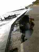
The council said it was too early to say what the cost of the repairs would be, but warned that the cliff face could be in jeopardy too if action was not taken. If the council does decide carry out emergency work it could apply to Defra for grant approval to recoup the costs.
Terry Allen, leader of Tendring District Council, said it was a worrying situation. "We will get back onto Defra and make a case for funding to carry out whatever remedial work is needed. "I just hope this can be sorted out as quickly as possible before there is further damage to the sea defences along that stretch of coastline."
The council said the Government changed the criteria needed to meet the guidelines for grant aid and meant sea defences did not score as highly as some of the inland schemes and slipped down the priority list.
The collapse was just yards along the front from where the council is spending £250,000 reinforcing 200 metres of seawall.
A spokesman for Defra said: "The Government is committed to flood and coastal erosion risk management across the country. It has invested some £4.5billion since 1996/97 and is considering future funding levels. However, there is not a limitless pot and schemes have to be prioritised. "The scheme at Holland-on-Sea did not score highly enough against other schemes to enable the department to grant aid it at the time. "Defra will consider any application for funding put forward by the council in respect of emergency works."
Fears over crumbling sea wall
From the Eastern Daily Press of 23rd January
This article tells of the concern of residents and Great Yarmouth Borough Council coastal engineer Bernard Harris over the bad news that Gorleston residents have been told they will have to wait until 2010 at the earliest for an £8m scheme to rebuild their crumbling sea wall.
They stated "We are aware the sea wall has been slowly deteriorating and there is the possibility it could fail catastrophically if we have a major storm. If the sea wall were badly damaged, the second thing to go would be a major sewer leading to sewage all over the beach."
Protect us - plea to Government
From the Eastern Daily Press of 22nd January

Reassurance is being sought from the government that Norfolk's battered coastline will be closely monitored following £5m cuts to the flood defence budget. In a letter to ministers, Norfolk county councillors also want a commitment to funds to allow the Eccles/Winterton beach recharge scheme to be reinstated together with other priorities shelved because of the cuts.
Speaking at a full council meeting yesterday, Ian Monson, cabinet member for waste and the environment, said: "Most of you will have read the headlines in the EDP about the £5.2m budget cuts to Anglia's Eastern Area flood defence budget, closely followed a few days later by the minister for climate change and the environment, Ian Pearson, stating that there may be hope of compensation for householders at Happisburgh and Trimingham threatened by cliff erosion.
"The statement from the minister may appear optimistic, but we cannot yet assume that it represents a change in government policy on the matter of compensation. The very real cut to the local flood defence budget is, in practice, the only clear signal we have of the government's intentions towards flood protection and the management of our coastline. The beaches are our most effective front line of defence against the sea and to disregard their loss is foolish. Environment Agency officials say that this scheme is 'pencilled in' for next year (2007-08) but we need greater reassurance that the scheme will actually happen, and that it won't keep slipping from a scale that is no longer economically viable."
The EDP reported that the Environment Agency (Anglian Eastern) regional flood defence committee had received details of its budget, which had been agreed by Defra nationally on a priority basis set this year at £33m - £5.2m less than last year. In Norfolk and north Suffolk, money will continue to be spent on the private-public partnership Broadland Flood Alleviation Project, and another £250,000 will be made available for smallscale developments in Yarmouth. A further £1m will go to improving flood defences along the River Wensum in Norwich, though this is from money raised by a Norfolk County Council levy on council tax rather than through funding from Defra. But a £2m scheme deemed essential by experts to protect the Broads from being breached at their most vulnerable stretch between Eccles and Winterton has been culled.
A motion passed by county councillors states: "We seek reassurance that the state of our coastline will be closely monitored over the forthcoming year and a commitment to provide sufficient funds to allow the Eccles/Winterton beach recharge scheme to be reinstated in the following year, alongside other priorities on the East Anglian coastline which have had to be shelved."
Flood Work Hit by Cash Delays
From the 'Suffolk Evening Star'
Further temporary work may be needed to protect 1,600 seafront homes in Felixstowe because the Government has still not agreed to cough up £6million for new sea defences.
Warmer UK seas could mean more jellyfish but less fish
The seas around Britain face an invasion of jellyfish because of global warming, a leading expert has warned.
Professor Martin Attrill of Plymouth University's Marine Institute, writing in the Limnology and Oceanography journal, says that climate change is already having a big impact on the ecosystems of the sea. Studying records of jellyfish in the North Sea, dating back 50 years, he has found that the warmer the conditions the more widespread are jellyfish.
Warmer conditions favour the survival of jellyfish, and Professor Attrill has found big increases in recorded numbers of jellyfish in the 1980s and 1990s. Also jellyfish are tolerant of increased acidic levels in the sea which is known to occur as the sea absorbs the rising emissions of carbon dioxide.
Professor Attrill believes that these increased numbers of jellyfish linked to warmer conditions may cause problems for fish stocks. Jellyfish eat not just fish larvae by also the zooplankton that fish and their young feed on. For example, in the 1980s an increase in jellyfish numbers in the North Sea coincided with a big crash in numbers of cod. This has been blamed on over-fishing and the waters being too warm to ensure full fertilisation at the time of spawning, but the jellyfish may also have played a role as predators. It is also to be noted that few other marine animals eat jellyfish so, if conditions favour their survival, their numbers may build up causing a marked change in the whole eco-system.
For more information about jellyfish, visit www.marinet.org.uk/mreserves/marineanimals.html#1jell
Beach Recharge - is this policy destroying our beaches and wasting our money?
For the past twelve years (1994 to 2006) the Environment Agency has been purchasing sand and shingle taken by the dredging companies from the offshore seabed along the East coast (and similarly elsewhere in the UK) in order to place this material back onto our worst depleted beaches in an attempt to maintain them and to prevent serious inland flooding. With insufficient funding for permanent long-term defences, and due to the continuity of offshore aggregate dredging combined with rising sea levels and worsening storms, this particular sea defence policy forms a temporary stop gap measure.
MSC Napoli Shipwreck - Information for Media
25th January 2007 - Could marine disaster have been avoided? Call for immediate Inquiry.
MARINET calls for full and frank inquiry into structural integrity of wrecked container ship MSC NAPOLI
Initial reports of the incident claimed that the vessel had been "holed" during storm conditions 40 miles south of The Lizard, but now more authoritative views, reported by Lloyds List, are claiming that the incident was caused by metal fatigue cracking which allowed water to enter and flood the engine room.
However, MARINET has discovered that as recently as January 2006 the vessel was surveyed by Det Norske Veritas, its Classification Society, and passed as being in 1A1 condition and fully seaworthy. (1A1 is supposed to represent the highest of standards).
MARINET has also discovered that, since that survey, 10 deficiencies were reported aboard the MSC NAPOLI during Port State Control Inspections in European Ports during 2006.
These include:
- 2 in engine and propulsion systems
- 2 in fire safety systems
- 2 in life saving systems
- 1 in navigation systems
- 1 in accident prevention systems
Speaking for MARINET Tim Deere-Jones (Marine Pollution Consultant) said:
"12 years ago Lord Donaldson published the report "Safer Ships Cleaner Seas" which made a series of hugely significant recommendations for improved standards of shipping and cargo safety. The report stimulated major national and EU wide initiatives to improve vessel standards by way of improved survey and inspection regimes.
"It is now deeply disturbing to find that the current survey and inspection regimes appear to be falling short of their goal, and are failing to identify and act upon deficiencies and structural weaknesses, resulting in a failure to achieve safer shipping. A full, wide ranging and very Public Inquiry and Report into the MSC NAPOLI incident, followed by an international level review of survey and inspection regimes, is the only way to prevent such incidents as this in the future."
For further information contact:
Tim Deere-Jones, tel. 01834-871011
Artificial Reefs Scoping Study by CIRIA (RP753)
The following article has appeared in in the January edition CIRIA's newsletter (Construction Industry Research and Information Association).
The traditional methods used for alleviating the effect of waves on the coastline have been around for decades and have as many critics as champions. Artificial reefs are a possible alternative to traditional coastal protection techniques and can also provide ecological enhancement through marine habitat creation and social benefits through increased tourism. There are also examples of reefs being created solely for habitat and amenity purposes which often make use of recycled or reusable materials; the reef in Loch Linnhe is one such example. In addition construction is underway in Boscombe for the first artificial surfing reef and it is hoped this project will increase beach replenishment as well as recreational benefits and will thus promote future uptake of artificial reefs for this purpose.
This project will examine artificial reefs as a viable alternative to traditional forms of coastal defence, and investigate the additional benefits to marine habitat creation and recreation that can be provided by them. This scoping study is not intended to give detailed technical guidance on artificial reefs but to provide a broad view of their use and future potential for adoption in this country.
Project status
This project started in January 2007
Project Funders
Environment Agency, Westminster Dredging, Royal Haskoning
Research contractor
Royal Haskoning
Contact CIRA
Victoria Cole, CIRIA Project Manager, +44(0)20-7549 3300
Simon Vilarasau, CIRIA Project Manager, +44(0)20-7549 3300
Villagers asked to dig deep to protect homes
From the 'Eastern Daily Press' of 19th January '07
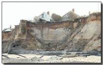
Villagers in Happisburgh were last night urged to dig deep into their own pockets to help protect their homes from coastal erosion.
North Norfolk District Council has already pledged to spend £200,000 on new sea defences for the village, which has become famous worldwide for its campaigning on the issues of coastal erosion and the demand for compensation for those who will lose their homes.
But the villagers themselves were asked at a public meeting last night to boost this figure by as much as possible in order to build even more effective defences. Although specific figures were not discussed in detail, it was suggested each household gives £100 to the cause. The donation was dubbed a "one-off insurance premium" by Jack Hall, chairman of the charity Coastal Concern Limited (CCL), an associate body to the better known campaign group Coastal Concern Action Group (CCAG).
The district council project is due to start in the middle of February, subject to approval of tenders. Villagers have been asked to make their minds up as quickly as possible - certainly within the final deadline of three weeks - about whether they are prepared to pay out.
Last night's meeting, held in the village church and chaired by CCAG coordinator Malcolm Kerby, was attended by around 200 people, senior council staff and campaign leaders.
Mr Hall told the gathering that CCL already had a "five figure sum" in the bank from previous community events, such as fetes and car boot sales. Because of CCL's charity status, the gift aid system could be used, potentially adding an extra £28 for every £100 donated to the final total. "Providing we act within the short time available, we have a unique opportunity. We are asking people to make their own individual contribution, perhaps £100 per household," he added.
Mr Hall said one of the key advantages of giving money now was that each and every pound would go towards materials and the cost of placing those materials; all overheads were already being paid from the £200,000 council pot. A simple system had been set up, said Mr Hall, which involved people collecting donation forms at the end of last night's meeting and either posting them once they had been filled in, or dropping them off at the village post office.
The meeting heard technical advice from the council's head of coastal strategy Peter Frew, plus contributions from the council's deputy leader Clive Stockton and chief executive Philip Burton.
Welsh beaches are being ruined by dredging
From the 'Western Mail' of January 16th '07 comes this story of the dredging damage wrought to the beautiful Welsh beaches.
WELSH beaches are being ruined by dredging that plunders more than a million tonnes of sand every year from our coastline, say environmentalists.
A postcard from the 1950s shows hordes of holidaymakers enjoying a summer's day on the golden sands of Rest Bay, Porthcawl. Today the same beach is barely recognisable, even taking into account the seasonal difference. There is much less sand, the rocks are more prominent, and visitors are increasingly likely to find themselves walking through alluvial mud.
Increasing concern over the removal of sand from our beaches for use in the construction industry has prompted a campaign group to call for a moratorium on further dredging. The Porthcawl Environment Trust, which has drawn particular attention to what it sees as the destruction of Rest Bay, says the Welsh Assembly Government should take urgent action to protect the coastline. Official figures confirm that more than a million tonnes of "aggregates" a year continue to be removed from the Welsh coastline at nine locations - Barry, Briton Ferry, Burry Port, Cardiff, Newport, Pembroke, Penrhyn, Port Talbot and Swansea.
Gary Victor, who chairs the Trust, said, "We began being concerned about the immediate area, but the more we have looked into it, it's clear that many parts of Wales are affected. Tourism brochures try to give the impression that the Glamorgan Heritage Coast is full of sandy beaches that are unchanged from 50 years ago. Yet in fact they are very different from how they used to be, because of the huge amounts of sand removed with the approval of the Assembly Government every year. This is a serious environmental issue, yet it is very difficult to get big players like Greenpeace and Friends of the Earth interested. It's time the Assembly Government realised the extent of the damage that has been done and took action to stop any further dredging. I am sure that construction companies could easily find alternative sources of sand. I recently visited Morocco, where there are huge quantities of sand from the Sahara that are encroaching on developed areas."
Mr Victor continued, "Obviously the removal of such large quantities of sand from our beaches will have an unwanted impact on tourism in Wales, but in the context of concerns about climate change it could also pose an increased risk of flooding. Offshore sand acts as a sea defence, and dredging could make the Welsh coast more vulnerable."
The Assembly Government, which issues dredging licences to private companies, said the practice was due to cease off Porthcawl in 2010. It also said that decisions on granting licences had been taken after considering comprehensive Environmental Impact Assessment reports. Increased monitoring has taken place since the last licence was granted in February 2003.
For local residents like Nyfa Saunders, who has an impressively assembled album of postcards showing Porthcawl in its leisure heyday, the failure to protect the coastline is a disgrace.
"When I was a child, it was possible to step off the promenade steps straight on to a sandy beach," she said. What we have now is not comparable in any way. It's a great shame."
Mr Victor fears the damage to the Welsh coastline was irreversible.
"When you compare the amount of sand that was on the beach in Rest Bay 50 years ago with the situation today, it is clear that dredging has had an enormous impact," he said.
"Most of the sand taken from around the coastline of Wales is along the Bristol Channel. The coastline on the other side of the Channel in North Devon has relatively little sand and is rocky, which is why dredging is not done over there. Local people can remember when cricket was played on Scarweather Sands, about four miles off the coast of Porthcawl, but the massive amount of sand taken by dredging in recent years stopped that. Sand is moved round according to the tides. In the winter, sand is taken offshore and deposited beneath the sea, returning to the shoreline in spring. But as the quantity of sand has declined through dredging, there has been less available to return to the beaches. Once sand has been taken away, it is not easy to replace. Who would pay for the millions of tonnes that have been removed from the Welsh coastline over decades to be reinstated? What should happen, however, is a moratorium on any further sand removal."
Most of the Welsh coastline is owned by the Crown Estate, whose revenue goes to the Treasury. But the decision on whether dredging should take place rests with the Welsh Assembly Government.
Mr Victor said, "When the Welsh Assembly Government last renewed licensing rights for dredging in 2003, it issued them for the maximum possible period of seven years. Until 2010, therefore, a million tonnes [a year] of sand will continue to be removed from the Welsh coastline. So far as I am concerned, this is little better than a burglar's charter."
In a letter to the chief executive of the Crown Estate, Roger Bright, written in the wake of Hurricane Katrina's devastation of New Orleans, Mr Victor stated, "We are told that Admiralty charts show that Nash Bank, a major sea defence for this area, is now half its size compared to 30 years ago. Figures from the Welsh Assembly show that you have sold over 110m tonnes of this finite resource over the past 50 years, and many people estimate that beach levels are now two or even three metres lower as a result. The loss of life and devastation that can result from storm surges in areas of low land must be taken seriously and not dismissed or forgotten ... Public attention is continually being focused on the fact that sea levels are rising and will go on rising, while your business activities are continually lowering our beach levels and sea defences. The combination of allowing greater volumes of water on to the foreshore by selling off our sea defences and lowering our beach levels, plus continual higher sea levels, is of concern to us and should be to you."
Mr Victor did not receive a reply to his letter from Mr Bright.
A spokeswoman for the Welsh Assembly Government said, "The environmental impact of marine minerals dredging has always been a key consideration in deciding whether to issue commercial dredging licences. The Environmental Impact Assessment and Habitats Directives have been applied in the decision process for many years. This process will be further strengthened when a new statutory framework for regulating marine-dredged minerals comes into force at the end of March this year and dredging on Nash Bank will cease completely in 2010."
Gower SOS
Opposition to dredging from the vast Helwick sand bank off Gower has grown as large areas of bare rock have replaced what were once golden sands on many of the peninsula's beaches. Port Eynon and Horton have been affected in particular and the fact Gower was made Britain's first official Area of Outstanding Natural Beauty 50 years ago has given added sensitivity to the situation.
In 2001, more than 30,000 people signed a petition calling for a moratorium on dredging until it could be proved there was no link between sand loss and dredging. Aggregate companies involved in taking hundreds of thousands of tonnes of sand a year from Helwick and other local banks have claimed there is no link. And they have pointed out there may be a need for huge gravel pits to be sunk in inland areas such as Pontarddulais or the Usk valley if offshore dredging is ever banned.
Dredging opponents say the issue is simple: sand should not be extracted until it can be proved conclusively the practice does not rob near by beaches of their sand. The issue has united Gower's tourist officials, farmers, residents and community councils.
Pressure group Gower Save Our Sands (Gower SOS) feels local people have been "betrayed" by the failure of successive Government and latterly Welsh Assembly officials to ban dredging. Spokesman Mike Jenkins said, "The politicians have turned their backs on the will of the people."
Mr Jenkins says the long-term future of the Gower as an area of outstanding natural beauty was in jeopardy due to dredging.
He said, "The bank is a glacial sand relic and is a finite resource. Once it has gone it will not replace itself. So much sand has been dredged along the shoreline that the beaches have dropped dramatically - by four to five feet in some places. Where there was once beautiful golden sands there are now bedrock and peat. We really rely so heavily on tourism if they take away the reason why people come to the Gower, the beaches, people will stop coming. We'd like to see a ten mile ban on commercial dredging off the shoreline."
Dredging at Helwick Bank started in the 1950s, although initially only in small amounts. It resumed in 1993 and around 500,000 cubic metres had been removed by 2002. Campaigners have uncovered pictures of beaches taken in the 1930s and '40s on Gower and compared them with modern pictures. Many show how sand has retreated.
Area 401/2, Great Yarmouth : Government prevaricates over licence decision.
The Department for Communities and Local Government (DCLG, formerly the Office of the Deputy Prime Minister - ODPM) is stalling on whether to grant a new aggregate dredging licence to Hanson Aggregates Marine Limited (HAML) for Area 401/2 which is situated 22 km offshore from Great Yarmouth, Norfolk. The original aggregate dredging licence, which HAML is seeking to renew, expired on 31st March 2006. HAML wants to renew the licence until 2013 when the Government has said that it will undertake a strategic assessment of all the aggregate dredging licences offshore from Great Yarmouth under the EU's Strategic Environmental Assessment Directive.
MARINET has objected to the renewal of the licence for Area 401/2, see www.marinet.org.uk/mad/objection.html#401 In January 2006 ODPM (now DCLG) wrote to MARINET to enquire whether the applicant (HAML) had satisfactorily answered all of MARINET's concerns. MARINET replied in February 2006 stating "The short answer to your question is that MARINET still has substantial concerns, and that these have been expressed to the applicant's consultant, Emu Ltd, and that these concerns remain unresolved" and MARINET informed ODPM of the nature of these concerns. ODPM (now DCLG) regulates the issuing of aggregate dredging licences by the Crown Estate who cannot issue a licence until the government has issued a favourable "Government View".
In the light of MARINET's reply of February 2006 to ODPM, MARINET has assumed that no favourable Government View would be issued until ODPM (DCLG) had informed MARINET of the government's view regarding MARINET's outstanding concerns. However by November 2006 MARINET had received no communication from DCLG (ODPM) and MARINET therefore enquired as to the current status of HAML's licence application. No reply was received from DCLG, and a further enquiry to DCLG was made by MARINET in December 2006.
DCLG replied to MARINET in a letter dated 21st December 2006, see www.marinet.org.uk/mad/objection.html#401 DCLG informed MARINET that a temporary Government View (GV) licence had been issued on 1st April 2006 for nine months (1st April to 31st December 2006) and that a further temporary GV licence had been issued on 21st December 2006 for a further six months (1st January to 30th June 2007). Further, DCLG advised that DCLG "anticipate the decision on the HAML application to dredge in this Area [410/2] up until the end of 2013 will be issued early in the New Year."
MARINET has replied to DCLG, see website address above, asking why MARINET, as a registered consultee who has unresolved concerns about the HAML licence application, was not informed by DCLG of the original temporary GV licence decision in April 2006 and has only been informed of the further temporary GV licence decision commencing January 2007 after repeated enquiry by MARINET to DCLG. Also, given that the actual licence decision up until 2013 is expected to be made "early in the New Year" (2007), MARINET has also asked DCLG whether it intends to discuss MARINET's outstanding unresolved concerns before a full licence decision is made. MARINET is currently waiting for DCLG's response.
MSC Napoli Shipwreck - Information for Media
22nd January 2007 - Information Update on Shipwreck of MSC Napoli, Devon, United Kingdom - Large number of serious environmental issues.
MARINET would like to draw attention to the following issues:
MSC Napoli : 62,000 tonnes, built 1991: UK Flagged : changed hands three times : current owners Zodiac Maritime, Tavistock Square, London
Port State Control Inspections :
These show the following safety issues have been reported in 2006.
The record shows 10 reported deficiencies in 2006. These include:
August 2006 inspection at Le Havre : 6 reported deficiencies (including 2 fire safety, 2 life-saving equipment, 1 navigation safety)
November 2006 inspection at Le Havre : (2 deficiencies : propulsion and auxiliary engines, 1 deficiency accident prevention)
The last recorded inspection by the Maritime and Coastguard Agency (MCA) was in May 2005.
Pollution Issues :
Oil pollution : deployment of booms almost always a waste of time : rarely effective except with very thick oil in very passive waters. In this case booms have been removed because of impact of floating containers.
MCA has informed us that some of the fuel is diesel.
If it escapes it will not be recoverable and will dissolve/mix in water column and evaporate fairly rapidly, thus highly dispersible. Also very eco-toxic and human health toxic, but due to high dispersibility eco-toxic effects may be relatively light.
MCA has informed us that approx 3,500 tonnes of fuel is bunker or heavy fuel oil.
Its grade uncertain, but it will be thick, black and very viscous and if it escapes it will be environmentally persistent, cause severe pollution on the shoreline and have the potential to cause significant impacts on any seabirds or sea mammal populations. Threats to marine environment potentially complex, similar to those seen in other oil spills. Heavy weather may create even more persistent emulsions of water in oil. The use of dispersant chemicals will create micro-droplets which will be more bio-available to certain shellfish.
Lyme Bay very important marine wildlife area : The seabed here is very important with rare habitats of marine life. There has recently been bitter controversy about fishing (esp. scallop dredging) in this area because of damage to rare seabed ecology and habitats. Thus oil pollution and hazardous materials in containers (see below) could cause significant damage.
Containers : Environmental campaigners have long been demanding that containers storing hazardous materials should be fitted with transponders. This would enable these containers to be identified, tracked and salvaged in situations like the present. Also, that containers and packaging should be indelibly marked with details of their contents (some of Napoli's packages are reported to be unidentifiable) and that full and detailed manifests/lists of contents for all containers should be readily available. Press reports cite Mark Rawson, safety manager at Zodiac Maritime (vessel owner), as saying that the current manifest is 100 pages long and therefore it is not possible to easily identify the hazardous component of the ship's cargo. It is believed that there are around 158 containers on board containing hazardous materials, and that so far 2 have been lost overboard. Overall it is reported at least 2,400 containers aboard, many of which are on deck. Risk of loss of more containers currently moderately high.
Salvage underway but effectiveness of salvage highly weather dependant. Method of fuel salvage not clear at present. It is obviously important to prioritise the removal of hazardous cargo but unless good information on the contents of the containers exists and is available then this priority salvaging exercise cannot be carried out. Some hazardous contents may be at the bottom of the containers stacks, so salvage effort of these too may be long and complex.
Highest tides (spring tides) have just peaked. From now on the tides will be progressively less high until the neap tides which means that MSC Napoli will become more "aground" on each tidal cycle, with the chance for "breakback" (the back of the ship breaking) increasingly high if ship's structure is severely compromised. This could cause rupture of the remaining fuel tanks and release containers stowed on deck and below deck. Weather conditions will be very important:
MARINET is the Marine Network of Friends of the Earth Local Groups, for additional information please contact:
Tim Deere-Jones: Telephone: 01834-871011
End
Coastal erosion study
'Bridlington Today' of 16th January carries an item on the erosion of the north Lincolnshire coastline and the significant archaeological findings brought about.
Flamborough and Skipsea's cliffs are part of 85 miles of coastline to be assessed for archaeological significance in the coming weeks. The coast from Whitby to Donna Nook, in Lincolnshire, will be assessed for archaeological significance by English Heritage, in the hope they can extract the secrets of the landscape before it is claimed by coastal erosion.
Peter Murphy, Coastal Strategy Officer with English Heritage, said: "Rates of erosion along many parts of the Yorkshire Coast are very high. It is also an area rich in archaeology, so it is a national priority to get the work done."
For further detail and to see some excellent photographs, visit the 24 hour Museum to be seen at: - www.24hourmuseum.org.uk/nwh_gfx_en/ART42105.html
Port of Tyne - Poison in the Water
From Newcastle Evening Chronicle 5th Jan 06
A ticking toxic timebomb has been dumped off the North East coast, environmentalists fear.
Official documents obtained by the Chronicle reveal 84,000 tonnes of sediment containing harmful toxins used in shipbuilding were dredged from the Tyne and dumped in the North Sea.
The toxic waste is lying four miles off the coast at Souter Point and it contains materials believed to reduce the effectiveness of the human immune system. It was dumped by the Port of Tyne Authority in March 2005 as part of a £3.2m trial to tackle a legacy of industrial waste contained in ports and rivers around the UK.
The Port of Tyne is the first in the country to try out the disposal of waste in this manner after applying to the Department for Rural Affairs (Defra) for a licence.
The official documents come from the Centre for Environment, Fisheries and Aquaculture Science, a marine science adviser to Defra. They reveal the waste sediment should have been buried securely under a 1.5-metre thick cap of sand and silt, but was in fact buried under just 0.65 metres.
Defra ordered the Port of Tyne to bump up the cap and last June it was increased to 0.8 metres thick, still only just over half the required thickness.
The document also reveals that Souter Point is a "dispersive" site, which means the toxic materials could potentially wash on to our beaches.
A large amount of the waste is made up of the anti-fouling agent tibutyltin oxide (TBT), used for many years on ships' hulls to prevent marine life from colonising there. TBT has been found to cause extensive damage to marine organisms and has now entered the food chain through the eating of sea life. In some parts of the world TBT levels in human blood are alarmingly high.
Engineer Bob Latimer, 63, of Whitburn, South Tyneside, is a member of Marinet, the marine arm of Friends of the Earth. He said: "They have tried to bung this waste in the sea and forget about it. They have tried to pass it off as normal dredge waste, but it contains harmful toxins. TBTs are designed to damage sea life so it seems ludicrous to me to put this toxin into the sea."
But Port of Tyne managing director Keith Wilson said the trial had been successful and was being constantly monitored. He said: "We have been researching this for eight years as part of a bid to finally completely clear up the Tyne.
"Following extensive consultations with Defra we were awarded a licence to conduct a trial for the disposal of this waste with a monitoring programme that is still on-going.
"It is a fact that the 1.5-metre cap was ideally to be achieved, but the cap in place is more than adequate and Defra is very happy with the monitoring going on.
"This is an issue that bedevils ports worldwide. It is the first time this disposal technique has been used in the UK. But it is a tried and tested technique used successfully in many other parts of the world.
"This is something where we have been progressive in that we have not buried our heads in the sand. We have spent £1.5m on monitoring of the situation and I am pleased to say it is a success."
Ticking Timebomb
Our industrial legacy has left us with a ticking toxic timebomb in the Tyne. Nearly 150 years of shipbuilding saw tonnes of waste toxins, metals and materials dumped in the river.
The Port of Tyne Authority decided it was time to deal with this and two years ago was granted a licence by the Government to carry out a trial dumping exercise at sea. Nearly 60,000 cubic metres of contaminated dredge material (CDM) - roughly 84,000 tonnes - was removed from three sites on the Tyne and dumped four miles off the coast at Souter Point. Some 29,314 cubic metres was pulled up from the Neptune Yard, 20,959 cubic metres from Wallsend Dry Docks, including Engine Works Quay, and 8,534 cubic metres from Swan Hunter's slipway ends.
The material was tested and found to be grossly contaminated with the anti-fouling agent tributylin oxide (TNT). Tests also revealed traces of dibutyltin (DBT), polycyclic aromatic hydrocarbons (PAHs) polychlorinated biphenyls (PCBs) total petroleum hydrocarbons (TPHs) and heavy metals.