
Meeting the Dredgers
A story worth reading by those considering the claims of the dredgers.
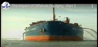
BMAPA, the British Marine Aggregates Production Association, announced two years ago that all aggregate dredging would cease offshore to Great Yarmouth because of the exhaustion of stocks and “because of their concern of the environmental impact”, stating that dredging operations would move to the south coast. But it came as no surprise this year that an application for a Government View was placed by Hanson Aggregates Marine Ltd. to renew the licence to further dredge from Area 401/2 offshore to Great Yarmouth. The company currently dredges for sand and shingle 22km off the Great Yarmouth coast, but the licence is set to expire on 31st March 2006. They had applied for a government View for a licence to continue the exploitation.
MARINET and the North Sea Action Group North Sea Action Group (NSAG), the East Anglian forerunner of MARINET, opposed the application as soon as it was launched. Letters of protest were sent to Marine Environmental Surveys, the company selected and funded by Hanson to represent them. Copies of these objections are to be found at Objections to Dredging Proposals
MARINET brought public attention to the new application by means of talks, circulars and general communications, so was not surprising that the application was opposed by a very large number of people consisting of householders, business concerns, fishermen, environmentalists as well as the numerous local councils concerned who had become aware of the further damage that would result with ongoing dredging. Faced with such a level of opposition to their plans, Hanson and BMAPA mounted well publicised presentation to give their side of the case in an attempt to convince the throngs of objectors that Marine Aggregate Dredging was good for them.
Their presentation took the form of an invitation to all objectors to their plans to attend Great Yarmouth Racecourse on Tuesday 19th April 2005 to see an exhibition and to receive a PowerPoint presentation and a series of talks by their own experts. Separate presentations were laid on at 12.00 midday, 4.00 pm and 6.00 pm that day. Each was well attended.
Little opportunity was permitted during or immediately following each speech by Hanson and BMAPA to allow the audience to deal with the inconsistencies and inaccuracies retailed, but this chance arose at closure.
The midday session was attended by Pat Gowen representing MARINET and the NSAG, Norfolk Green Party, Norwich and Great Yarmouth FoE Groups, numerous coastal dwellers, fishermen, farmers and business interests, plus those concerned of the well being of our broads, vulnerable inland villages and the marine and coastal environment. Unknown to Hanson, a considerable level of knowledge and expertise were present, all of whom were protesting in the strongest terms at the plan to dredge.
The main stress was placed on the vital need of aggregates to furnish the needs of housing such as those proposed in the East of England Development Plan. “Without our provision of aggregate a shortage of affordable housing will result” was the claim, as was it that the dredgers were “providing a vital national resource”.
Some quite astounding claims were made by BMAPA and Hanson during the course of the presentation, whilst the powerful evidence of the findings of damage proven by world experts were dismissed and rebuffed. “We are the world experts in this field” said Mark Russell, Development Manager of BMAPA. “No evidence exists to show that offshore dredging to be a cause of erosion” he claimed.
All evidence presented of the damage resulting was rebuffed, put down by Hanson and BMAPA to those opposing their plan as “their being fuelled by misinformation” and that this was “an incorrect perception”. Much of their defence was promptly seized upon by those attending, all resulting in some astounding claims, which included: –
“There is no ban on dredging in Holland – they dredge twice as much material as the UK” was stated by Mark Russell, Development Manager, British Marine Aggregate Producer’s Association. But he didn’t say that other than to keep their ports clear for navigation, they were not permitted to dredge within 25 km of their own coastline, and then only in sea depths of more than 20 metres, and, that Van Oord were dredging off our coastline, over one third of which aggregate was taken to Holland. The Dutch and Belgians, due to the erosion and damage to fish stocks known to be caused, ceased commercial aggregate dredging eight years ago. They now rely upon importing their needs of sand and gravel from Britain, taking over 7 million tonnes of the aggregate dredged offshore to Great Yarmouth each year. This is mainly used to build their beaches and protect their coastline, this use taking 9 million cubic metres of sand annually, compared with just 2 million used in Britain.
Mark Russell stated that their aggregate was beneficial to the local shoreline as much of the aggregate was used to place back sand on the denuded beaches. But what wasn’t said was that the aggregate to be taken for this application was entirely to go to Holland, Belgium and London, with none whatsoever to be used for our local shoreline. Their own EIA gave the submission by the applicant that:
“The resource under consideration in the Area 401/2 will provide for the continuation of a suitable resource for building materials to meet future needs in the South East [UK] and The Netherlands.” (Reference: Environmental Statement (ES) Appendix C, section C.8).
They further stated at the meeting (whether by accident or design) some really amazing assertions, among them:-
- That sea levels are going down by 2mm per year. This would come as a great surprise to the Climatic Change researchers and coastal morphologists.
- That the Scroby Sandbank (adjacent too the main dredging site) has not diminished in the past 20 years. Pat Gowen and many others visited this offshore island many times prior to the commencement of offshore aggregate dredging, to find marram dunes, seal colonies and nesting terns, as the bank was never below water even on the highest tide. Now it is only exposed on the lowest of tides.
- That the SNSSTS got it all wrong and Hansons were right, as they (Hanson) were the world’s experts in this field. No comment !
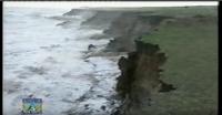
- That no increase in the rate of erosion has come about this past 20 years. This must have come as a great surprise to the many present that had seen their previously accreting beaches and dunes devastated by ever increasing capture by the sea. The evidence is clear for all to see.
- That they were being ‘targeted for political reasons, and could not understand why (!) Well, scientific, moral, ethical and social reasons maybe, but it takes a stretch of the imagination to see where politics figures in this.
- That there was no onshore to offshore sand movement. We must assume that sand and shingle are soluble in sea water, and that the evidence on the sediment drift supplied by Hanson themselves later in the afternoon was wrong. Well, one or the other, but not both.
They showed many other inconsistencies in their presentation, and succeeded in contradicting themselves many times over. They at first said that they only skimmed the sand surface whilst dredging, later in their presentation that they took 2 metres off in depth, later that they took only the top half a metre, later still that they dredged right down to the bottom of the layer.
They claimed that they were only dredging only a very small area and that it was too far offshore to impact the coastline. But in fact the area asked for constitutes 50.96 sq.km, and is less than 22 km offshore. It is in fact yet a further addition to the major licensed dredging site, most of which is less than 3 miles (ca 5 km) from the shore as shown on the map below. Empirical research 20 years ago by the American Corps of Engineers proved that dredging a total of less than two million tonnes of sand over a four year period 14 miles from the coast of Cape Canaveral brought about massive erosion of previously accreting beaches forty miles away.

Since dredging commenced off the Humber and in the Wash, from where comes the sediment for our East Anglian coastline, an annual deficit of between 300,000 and 450,000 cubic metres of sand has been brought about. The explanation given by BMAPA and Hanson that the sediment flow has all but ceased was due entirely to the sand capture of the sea defences, completely ignoring my pointing out that in fact many of such defences had not been maintained and so were increasingly permitting additional release of shoreline material previously held. They “didn’t know where all the cliff and dune and beach loss release had gone to” and offered no comment to my pointing out that the loss of sediment flow was obviously due to the interception of the supply deposits off Humberside, Lincolnshire and The Wash areas.
They initially said that they dredged 5 miles offshore, then twenty miles offshore and later still immediately beside Scroby. (The above map shows the facts). They did not say that prior to GPS navigation recording dredging was taking place well within a mile of the coastline. They did not admit that the snapshot study at the time of dredging did not allow for the fact that the erosion that followed came long after the dredging, lasted far longer, and was effected over a much wider area (as proven by the American Corps of Engineers).
At one point Dr. David Bellamy of BMAPA stated “the dredging can’t effect Happisburgh and Winterton because the sediment drift is north to south” later saying it was south to north, yet in both cases that it could not therefore possibly effect Happisburgh, Winterton, etc.
This point was taken up by Robin Chenery, who asked Hanson to clarify this contradiction. They then stated that their application for Area 401/2 did not stop the sand from coming ashore to make up the beach between Great Yarmouth and Lowestoft as in fact “the sand was going the other way”. The presenter continued: “Let’s go back to the beginning – your cliffs in North Norfolk fall into the sea and become beaches – the coastal drift works the sand along the coast, and when it reaches Great Yarmouth to Lowestoft it leaves the coast to settle offshore. In the deeper water it is no longer affected by the waves, but is slowly dragged by the fastest tide which out here is on the ebb, which runs parallel to the coast.” The ‘independent expert’ from Oxford confirmed this, and went on to say that it’s a pity we can’t hold on to our sand as it gets in their way, because they only take a little sand, it being mainly the shingle deposits laying under it that they are after.
Later in the session Robin asked the question where the north going sand from Area 401/2 would go to. The response was that “it will slowly be dragged along by the ebb tide parallel to the coast via the offshore sandbanks” and, describing an arc with his left hand, continued “it will arrive at the coast north of the Cromer to Wells area”. So Robin asked “Into an area where the north to north-easterly gales can then drive it ashore to replenish our beaches ?” “That’s right” he said, the Oxford expert agreeing. Robin thus pointed out that their dredging therefore does affect our beaches, because what they described was a conveyor ‘on it’s side’, saying “If you dredge and interrupt the flow anywhere on the conveyor the deficit will eventually work it’s way round.” At that point the subject was rapidly changed to that of another question.
At the following meeting two hours later Robin again asked about the sand from Area 401/2 going north, adding “You know that this sand had been our cliffs in North Norfolk.” But by now the ‘expert’ had changed his mind, and stated “Oh no! That sand has been out there for millions of years.” When pressed on where the sand was going he then said “North at first and then through the banks to the north-east” waving a hand in the general direction of Holland. Unfortunately, that direction is at right-angles to the tide. Thus, within four hours, a completely different set of circumstances had been invented.
This was not the only inconsistency displayed. First, Hanson claimed that they were dredging in waters of greater than 20 metres deep, later, beside the Scroby sandbank, later 40 metres in depth.
They did not refute my accusation that their ‘findings’ were based upon their own computer simulated assumptions rather than actual empirical evidence which proved otherwise. They refuted the overseas findings saying that these were not comparable to the North Sea ‘which is unique’. Questions on the evidence of dredging creating erosion as in the Eurosion document were not answered, as were not many others.
They openly admitted that the EIA’s were performed by those they selected, appointed and paid, saying “this was the only way to get them done” and that they considered no second opinion to be necessary.
They gave incorrect figures on the income derived by The Crown Estate and government taxation, and were “unable to give a figure on their own turnover or their profits”, which resulted in much ridicule from those present. But at least all these stunning self-contradictions, inconsistencies and obvious untruths adequately demonstrated the poverty of their argument, all to our advantage.
To our group they claimed that their dredging has no affect whatsoever upon erosion. But, at a later meeting held at 4 pm (so reducing the opposition numbers) with the angry people losing their properties without compensation, they for the very first time admitted that dredging caused erosion. This was accomplished without the breaking of any arms or the administering of a truth serum in their tea. (They must have been worn down by our first session). Needless to say, this sudden change of stance was avidly picked up by our Radio Norfolk. You can hear the broadcast using ‘Real Audio Player’ if you visit:- www.bigjimsbox.com/radionorfolk190405.ra
This 4 pm session produced a demonstration with placards held by a number of impacted coastal village residents of Winterton, Scratby and Happisburgh. They denounced the application and insisted more research needed to be done into the possible link between dredging and coastal erosion.
Malcolm Kerby of the Coastline Concern Action Group called for a “moratorium placed on all dredging in British waters” until there is adequate proof that aggregate dredging did not impact on the nation’s shoreline. “I would like to see it stopped immediately,” he said. “If there is the slightest doubt of any description, it should be stopped. I’ve got documentation that says offshore dredging causes coastal erosion.” He added that more independent research needed to be carried out.
Jim Bratton from Scratby said he would need “more convincing” before he would accept there is no connection between the North Sea dredging site and coastal erosion at his village, adding “If you’re dredging sand from the ocean bed and losing sand from the shore, it’s a strange coincidence,” he said.
David Harding, spokesman for Hanson Aggregates Marine, said the company had proof that there is “no link between dredging and coastal erosion” but those present were well aware that such proof was lacking, and that the EIAs were not impartial. Great Yarmouth Borough Council’s remained unconvinced by Hanson’s presentation and objected to the renewal of the dredging licence stating there is “insufficient evidence to demonstrate that such activities do not impact upon the coastal processes and erosion of the coastline”.
The timing of the renewal application has made the impact of dredging on coastal erosion a major political issue for local parliamentary candidates in the run up to the general election. Earlier the Labour MP for Great Yarmouth Tony Wright expressed his concerns about the renewal of the application and this week whilst his Conservative counterpart Mark Fox also announced his opposition to the practice of offshore dredging.
“I support putting in proper sea defences – onshore or offshore,” he said, “and I personally support the idea that residents who lived there before the problem was known should be compensated by the Government for any insurance difficulties.”
Thus, Hanson and BMAPA rather lost the day, producing rather the reverse of that they intended to accomplish, that of a cessation of objections. The consensus of opinion was that BMAPA and Hanson were dredging up anything they could to defend their practice in defence of their profits. Those that went with an open mind did not appreciate rubbish being thrown into it, and came away now convinced of the threat of dredging to our coastline.
Pat Gowen, 15th July 2005