
Report on the November 2007 North Sea Surge — More Norfolk Coastline Loss
Normally one does not expect North Sea Surges to appear before the end of February. But already we have already experienced one at the end of September and another now a far worse one on 9th November ’07.
This is in line with forecasts made by climatologists, who predicted long ago that Global Warming would bring about more severe winter storms that come more frequently and last longer. Global Warming has also brought about a sea rise of 3.2 mm per year and to this coupled to a land sink of 2 mm per annum can be added to give an equivalent sea rise of 5.2 mm each year, gradually but decidedly increasing.
The North Sea surge that hit the East Anglian coast between 0500 and 0900 on the morning of 9th November did not come on one of the highest tides, but nevertheless stripped between 2 and 5 metres of sand off most of our beaches, taking them down to the marlMaerl Maerl is a collective term for several species of red seaweed, with hard, chalky skeletons. It is rock hard and, unlike other seaweeds, it grows as unattached rounded nodules or short, branched shapes on the seabed. Like all seaweeds, maerl needs sunlight to grow, and it only occurs to a depth of about 20m. and bed clay on many. It took between 5 and 15 metres from our dune fronts and sand cliffs, undermining and damaging many sections of what few sea defences exist. The sea defences were breached at Salthouse and Walcott, and water cut off several main roads including the A12 and the A149 main coast road. Although much property was damaged, thankfully no lives were lost, as over 2,000 vulnerable people were evacuated to safety overnight.
The surge tide was not near so bad as that of February 1953, when over 300 people drowned and huge tracts of agricultural land were inundated. Had the wind not have veered more westerly and dropped in its velocity, the situation could have been far worse on the following high tide. Had we had 1953 conditions again, because the sea has risen by 150 cm and East Anglia has sunk by 100 cm since then, the surge sea level would have been 250 cm higher, bringing the sea more than halfway up the bedroom windows in the lower areas of Great Yarmouth and flooding huge inland areas of Norfolk and Suffolk. The Great flood of 1963 did not come on the highest tide, and much of our sea defence have been lost since then.
The story can be told in pictures.

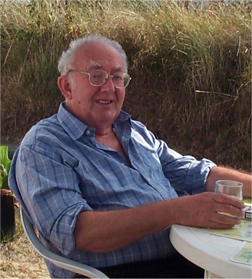
First, my photograph of Norma, my lady wife standing on Hemsby Beach where the dune face once was until the surge took 10 metres from it and 3 metres of sand depth. Luckily our coastal bungalow survived.

Next my photograph of Winterton beach where before the surge the WW-II tank traps were at the dune base.

The main coast road at Walcott blocked by boats, caravans, sheds, mud, sand and debris.

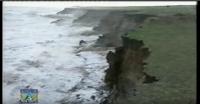
Happisburgh, depicting a severe cliff loss of over 10 metres, all sand stripped from the beach leaving mud, and showing the pulverised remains of lost dwellings.

More structural damage at Walcott

The picture is of Scratby Beach following the surge. Even more dune and beach sand was lost here than at adjacent Hemsby. This had already lost much sand and frontage from the smaller previous surge in September.
The impact of the surge can be seen at numerous other websites. A dramatic series of pictures can be found at BBC Look East.
All this is very bad news, as it is coming at a time of elevating sea rise due to Global Warming, stronger and more frequent storms forecast, continuing East Anglian sinkage, ongoing offshore aggregate dredging, and when DEFRA are reducing funding for coastal protection and enforcing their Shoreline Management Plan that demands the loss protection for much of our most vulnerable coastline, prettiest villages and precious wildlife sites.
Much river and Broadland flooding also came about as the surge tide travelled up the rivers, salinating them and the Norfolk Broads plus large areas of farmland as well as flooding as far inland as parts of Norwich. Yet the government will not even consider placing a Yare and/or Bure barrage to protect.
Pat Gowen, 11th November ’07