

The Disappearing East Anglian Coast
Many thousands of years ago there was no North Sea. Initially covered by glacial ice, later by a dense oak forest, East Anglia was joined to the European mainland. The only reminders of this remaining today are the semi-petrified tree stumps exposed at Norfolk’s rapidly eroding Holme-next-the-Sea beach, and the roots of the ancient oaks that are washed up along the Norfolk coastline after south-westerly gales following dislodgement by dredging.
Later as the land sunk the ‘English River’ came into being, this to become the ‘German Ocean’ and now the North Sea. For many centuries now the coastline of East Anglian has been slowly eroding for natural reasons. Apart from the effects of the onslaughts of major storms and surges, it has been a slow and steady but nevertheless relentless regression. In the short term the high beach sand loss resulting from the strong onshore north winds of the winter months were once mainly counterbalanced by reinstatement during the summer months, this by the onshore sand movement brought about by the onshore undertow of offshore south to south west winds. But soon after large scale cumulative commercial offshore aggregate dredging commenced, the sediment traffic became mainly one way only, with far fewer beaches accreting and far more eroding at a much faster rate.
The reasons for the sudden and rapid demise of the East Anglian coastline over this past thirty years are manifold, but with only three of the known six causes being ‘natural’. The first two of these are very minor compared with the others. The causes follow in order of magnitude.
1. East Anglian Sinkage
The stretching of the Eurasian tectonic base plate from the North American continent is causing Scotland to slowly rise from the sea, whilst the melt of the original heavy glacial ice sheet has also permitted Scotland to rise. The resulting tip effect has caused south-east England to sink. Although this rate was as much as 3 millimetres per year in the past, it is now judged to be in the region of 1.5 – 2mm per annum and still reducing. Kent, Essex, Suffolk and Norfolk plus part of Lincolnshire are very slowly sinking. Man does not have the technological ability to tackle this, which is a natural threat.
2. Geology
East Anglia has large areas of low laying land, much below the high tide sea level. Its coastline has only one tiny area with any hard rock around West Runton, as most of the shoreline consists mainly of soft sand beaches with marram dunes, low soft sand cliffs and salt marshes that are easily undermined by wave attack if the protective frontal beach sand has been lowered. Although parts of the coastline are protected by a sea wall, many areas have little or no defence other than now rapidly receding groynes, so is still open to wave attack. The rivers of East Anglia are tidal up to twenty miles inland and the entirety of the river entrances to the Norfolk and Suffolk Broads are open to the sea with no barriers, weirs or lochs. Thus, when the sea breaks through as it did in the tidal surges of 1938 and 1953, large areas can be flooded, destroying housing, drowning people and salinating valuable farmland.
3. North Sea Surges and Combination Effects
On the night of 31st January 1953 came the East Coast Flood disaster when a sustained Force 11 northerly gale forced a sea rise of almost three metres above the normal high tide (a ‘North Sea Surge’). The sea defences, despite warnings, had not been maintained. This surge caused the loss of over 100 lives in the County of Norfolk alone, where 5,000 homes were destroyed and 40,000 acres of arable land were flooded by the sea. In Essex, 37 people drowned at Jaywick where 7,000 people were left homeless. At Canvey Island 58 died and the entire population of 11,500 had to be evacuated. Three hundred and seven lives were lost throughout the United Kingdom, but on the other side of the raging North Sea in Holland over 2,000 died. The 1953 flood was the most widespread and devastating natural catastrophe in living memory.
Such a surge results when: –
- The moon has a high northerly lunar declination, i.e. it is at high elevation in the northern hemisphere sky, thus, gives a counteracting increased gravitational pull adding to sea levels in the northern hemisphere.
- The moon is at or close to perigee, e.g. closest to earth, so producing additional gravitational pull away from earth, this further allowing a far higher sea level above the predicted norm.
- It is one to four days following a new or a full moon, when the gravitational pull of the sun and moon combine to produce far higher tides, but with the 1 to 4 day lag caused by water movement delay.
- A deep low-pressure system exists over the North Sea, particularly when this is backed to the west by a following barometric high so giving powerful northerly winds as a cyclone.
- A high level and sustained inland rainfall comes about over 2 – 3 days, which brings high water levels down the rivers preventing a high water escape reservoir to the Broads, Breydon Water, etc.
- A severe and sustained Storm Force 10 or 11 NNW gale, +/- 20 degrees.
The strong northerlies then drive the risen sea down to the south, where it meets the narrow and shallow English Channel. The resulting high tidal level cannot escape due to the wind pressure, so if the northerly gale is sustained the following high tide comes over the previous. When added to by the other factors above, tidal levels greater than 3 metres above the predicted norm can result. (See ‘North Sea Surges’ on this website).
Up to this time only three of the causative factors have combined. The 1953 flood did not come on the highest tide, and then our sea levels were lower, our defensive dunes higher and our beaches far more extensive, whilst climatic conditions were not so severe. Furthermore, few houses were then built in known floodplains. East Anglia could be hit far more in the next major surge. Three weeks either side of mid-February is the dangerous time.
Each year this threat increases. It is not if another surge comes about, but when. As aforesaid, the 1953 flood was not on the highest tide, and with other factors now brought into the equation, the rise in sea level could now be more than one to two metres higher than any experienced earlier.
4. Global Warming
Since the industrial revolution of the nineteenth century earth warming has played its role in bringing about the encroachment of the sea. Increasing carbon dioxide emissions from power stations, industry, aircraft and traffic have resulted in ever rising sea levels. Polar ice cap and glacial melting is now adding over two millimetres per year and this melt rate is increasing.
Further to this effect on sea rise, thermally induced sea expansion is giving an additional sea level increase of up to six millimetres per annum, and this too is increasing. Yet another factor due to man-made Global Warming is the increasing frequency and the severity and duration of winter gales, these producing higher tides, larger and more frequent surges and bigger waves. The eroding power of a wave is proportional to the height of the wave crest, so now the more frequent and severe northerly winter gales strip more sand and gravel from the shoreline out to sea, where it then naturally replaces that removed by dredging instead of returning to the shoreline with the undertow accompanying the offshore winds of the summer.
Yet another factor in the equation is that the increasing and deepening barometric lows that accompany Global Warming produce far higher sea levels over the beaches and so bring the sea up to the dunes and sea defences to threaten further underminement. Thus these surges additionally serve to escalate erosion and the rise and inland progression of the North Sea, so to increase the threat of flooding.
5. Loss of Sediment
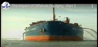
The rapid increase of erosion of England’s eastern seaboard evidenced over the past twenty years is far greater than can be ascribed to the above factors. If one calculates by simple trigonometry the encroachment of the sea as its mean advance up the slope of a given beach and attempts to blame it simply on sea rise and land sinkage, it fails to account for more than some ten to fifteen per cent of the advancement of the encroaching sea. There is now research and strong supportive correlated evidence proving that offshore aggregate dredging is the main culprit playing the major role in the loss of our coastal fringe.
East Anglia, mainly offshore to Great Yarmouth, has by far the greatest level of sand and gravel seized by intense industrial offshore aggregate dredging over the longest period. It is thus not pure coincidence that East Anglia also shows by far the worst beach, dune, salt marsh and, sand cliff erosion.
Other countries do not permit such intense exploitation. Holland does not permit dredging within 20 kilometres of its own coastline. Denmark closely regulates any dredging operations by constant monitoring of the effects before, during and after dredging, and demands that two metres depth of untouched sand remains on the seabed. (In Britain the take is right down to the chalk and clay base).
France restricts its take to 3 million tones per annum. Germany prohibits all dredging in all areas where any adverse ecological impact is thought possible. Belgium only permits the extraction beyond 10km offshore, and uses the royalties gained to fund research into the effects. There are no such effective conditions or restrictions in the United Kingdom. The myopic assessments of ‘no damage to the coastline’ are made by those selected, appointed by and paid by the dredging companies themselves without opportunity of a second opinion are recognized by the government and the licensing authorities, both of whom are interested parties in the profits that arise from dredging operations. No other research findings are recognised.
Over 40% of the dredging areas of the United Kingdom licensed by the Crown Estate and the Government are offshore to East Anglia where over 200 sq.km are so designated. In the twelve years between 1989 and 2003 a total of 113,937,813 tonnes of aggregate was landed that had been seized offshore to Norfolk alone.
However it must be recognised that almost twice the quantities listed were actually stripped from the seabed because only that of course granular quality is held as being suitable for concrete. The non-commercially viable large stones, fine material and silt, being surplus to requirement, were dumped back overboard into the sea as waste. Such fine sediment has few cohesive properties either on the seabed or on beaches. It has no habitat value and offers little resistance to tidal and wave wash off, so is a further factor in destabilisation.
The operation changes the sea flow patterns, deepens the offshore sea bed to permit greater waves, increases the beach slope by draw downdraw down The process by which tides and wave motion remove (draw down) material from a beach and pull it out to sea. A sandy beach experiencing draw down is thus denuded of its sand. The process can be natural (i.e. winter storms) or can be artificially caused (e.g. aggregate dredging, whereby the dredging of sand and gravel offshore causes sand to be drawn down from the beach in order to replace the material which has been dredged). of the sand and shingle back out to the sea and seizes that material that would otherwise had returned to the shoreline and littoral driftlittoral sediment flow This is the flow or movement of sediment (sand, shingle or pebbles) along a beach or coastline. The flow or direction of movement is usually determined by the tidal and wave regime dominant in the area.. It further reduces the area and height of the offshore sand banks that would otherwise serve to protect the shore from the larger winter waves.
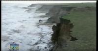
The impact of offshore dredging upon our coast has been dramatic since the onset. Beaches and dunes that had been accreting since living memory began to suffer serious losses from Holderness on the Yorkshire coast right down to Essex. In Norfolk, where four dune systems existed between Hemsby Gap and Winterton, now only one rapidly eroding bank remains. Here 94 bungalows have been lost to the sea, all without compensation or the ability to insure. At Happisburgh over 30 properties have been lost. The coast roads have been taken at Overstrand, Happisburgh and Trimingham. Sea defences and promenades have been damaged at Weybourne and Corton. Felixstowe pier and approach road are threatened with underminement. Beaches that were accreting over the past one hundred years have lost many metres of sand depth and have become foreshortened, steeper and stonier.
Now East Anglia is being faced with more threats to its coastline and inhabitants. The funding for marine defence has been reduced, and a policy of ‘managed retreat’ is in vogue. (See ‘Shoreline Management Plans’ on this website). Many low elevation coastal and inland villages are threatened with flooding and the Norfolk Broads are threatened with salination. Numerous wildlife sites may be lost whilst beaches that were previously accreting for the past one hundred will foreshorten and disappear in many resorts. The main income of Norfolk from tourism may disappear.
It is thus little wonder that the people of East Anglia are so concerned over the threat to its area, habitation and livelihood, and why opposition to offshore aggregate dredging is so much in vogue.
Below is the new map of East Anglia when the West Antarctica Ice Shelf melts due to Global Warming and the vital sea defences are no longer maintained. We have Ely and Cambridge-on-Sea and a vast amount of land under it.

Pat Gowen, 24th November 2005