
Impact of the North Sea Surge on the East Anglian Coast
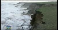
The devastating North Sea Surge along the Norfolk and Suffolk coast in December wrought serious damage to many homes by wave overtopping, breaches to those sea defences that were present and underminement of the ground that residences stood on where there were only naturally formed marram dunes. Five bungalows were undermined and destroyed at Hemsby, with more to descend from their foundations when the undermined dunes drop to the beach below. The sea rise brought the sea level up to within a few inches of overtopping the flood gates at King’s Lynn, narrowly avoiding a catastrophic flooding of the town.

Lynn’s flood defences hold — but only just. The water nearly made the very top of the flood defences at St Margaret’s Lane on the South Quay
The sea surge came to within a few inches of spilling over the wall protecting Great Yarmouth from flooding. Many of the houses at Walcott were severely damaged and flooded due to waves overtopping the sea wall there, whilst serious flooding resulted at Cley, Blakeney and Wells, where important wildlife sites and reserves were under sea water.
The surge that came on December 8/9/10th brought much of the Norfolk and Suffolk coast to resemble a war zone due to all the damage created. It came rather unexpectedly, as up to this year such events were confined mainly to the last week in February. (See ‘North Sea Surges’ at https://www.marinet.org.uk/campaign-article/north-sea-surges-2 ) But with the dramatic change in weather patterns brought about by climate change, for the past year they have been coming out of season, with surges occurring in April, November and December in 2013.
The devastating North Sea Surge along the Norfolk coast in December wrought serious damage to many homes by wave overtopping, breaches to those sea defences that were present and underminement of the ground that homes stood on where their only protection were naturally formed marram dunes. Most of the houses at Walcott were severely damaged due to waves overtopping the sea wall, whilst serious flooding resulted at Cley, Blakeney and Wells. Five bungalows were undermined and destroyed at Hemsby, with more to descend from their foundations when the undermined now vertical dunes drop to the beach below.
Altogether 20 km of 840 km of tidal defences along the Norfolk, Suffolk and Essex coast were damaged or breached by the raging sea.
It was by far the worst coastal impact for sixty years when we experienced a close repeat of the meteorological conditions of 1953. As East Anglia has sunk by almost 10 cm and the sea has risen by 23 cm since then by global warming induced glacier melt and thermal expansion, the impact would have been far worse with like conditions. In 1953 300 people died, but not a single one this time, mainly because 9,000 people were evacuated from their homes and businesses. Not so at Hemsby though, which was not a designated in a flood area, so was initially ignored by the emergency authorities who up to now have dismissed the hazards of erosion and its main cause. All the Hemsby residents received was an early warning of the likelihood of a major surge sent out by MARINET three days previous.
Equally as tragic as the direct impact upon people, the natural environment was also severely hit.
Many hundreds of grey seals were lost along the north Norfolk coast due to the deadly storm surge. The National Trust, issued a statement confirming that 263 seals have disappear from the beach at Horsey Gap alone.
The internationally famous freshwater wildlife and bird habitats of the Cley Marshes, Brancaster, Salthouse and Blakeney, claimed by many to be the best natural sites in Europe were inundated, and such is the cost of reinstatement that the Environment Agency are now thinking of abandoning them to the sea. Paul Lenster, EA head, told a committee of MPs are considering whether to attempt to re-establish these freshwater habitats and also whether to reinstate flood defences in Brancaster, Blakeney and Salthouse that were breached in the surge.
It goes without saying that the news that vital parts of Norfolk’s coastline could be permanently sacrificed to the sea was greeted with dismay by conservationists and ornithologists, as it these are freshwater environments, where birds which flock each year to breed, which attract many thousands of tourists, vital for the local economy..
Blakeney nature reserve has a unique mix of salt marsh, mudflats and freshwater marsh nestling around the famous Blakeney Point, a four-mile-long sand and shingle spit that has formed over hundreds of years on the shingle ridge. It provides a rare habitat valuable for unusual plants, insects, birds and seals. It is an internationally-important breeding area for seabirds, and home to a colony of both common and grey seals.Other differing habitats host their own diverse range of special wildlife.
Brancaster National Nature Reserve is considered to be the finest saltmarsh in the UK containing plant species of national importance such as matted sea lavender and sea heath, whilst adjacent Scolt Head Island supports nationally and internationally important numbers of breeding Sandwich, Common, Arctic and Little Terns with other wintering wildfowl and waders such as Brent Geese, Shelduck, Widgeon, Teal and Curlew.
The plant communities of the Brancaster dunes and saltmarshes are classic examples of their type of habitat. The reserve covers an area of some 727 hectares of sand dune, beach and saltmarsh, which is owned jointly by the National Trust and Norfolk Wildlife Trust, and has been a nature reserve since 1923. It is managed by Natural England. Brancaster is also home to the National Trust-owned Brancaster Activity Centre, which was first hit by the floods on 5th December.
Cley Marshes that exist between Cley and Salthouse on the Norfolk Coast is Norfolk Wildlife Trust’s (NWT) oldest and best known nature reserve. It was purchased in 1926 by Dr Sydney Long, founder of NWT, making it the first wildlife trust reserve in the country. It is one of Britain’s best nature reserves for bird watching because the many pools and scrapes that attract many thousands of birds. This site is unusual because of its variety of habitats on the saltwater and freshwater marshes.
The scrape pools there are used widely by breeding and migratory birds. The shingle bank is home to unusual plants including the yellow-horned poppy. The shingle beach and saline lagoons, along with the grazing marsh and reedbed, support large numbers of wintering and migrating wildfowl and waders as well as bittern, marsh harrier and bearded tit.
During the spring the pools are full of wading birds including the spotted redshank on their way to Arctic breeding grounds. Sedge, reed and grasshopper warblers can be seen in the reedbeds. The Cley Marshes is one of only a handful of sites in Britain with breeding bittern at this time of year. Birds including the white and black-feathered avocet breed on the marshes in the summer. Throughout August and September waders return to the site and feed on insects and worms in the pools before continuing their southward journey. When winter approaches large numbers of wildfowl including widgeon, teal, shoveller, and pintail gather. The shingle bank is popular with flocks of goldfinch or linnet during this time. The Cley Marshes Visitors Centre opened in summer 2007.

Blakeney after the 2013 tidal flood. PHOTO: ANTONY KELLY

The A149 main coast road (impassable for three days) and Cley Marsh Reserve at Salthouse taken by Antony Kelly.

This photograph of a seal swimming (within the speed limit) along the A149 coast road near Cley was taken by Marcus Nash of Hindolveston. Hundreds of seals are thought to have lost their lives in the deadly tidal surge

Steven Kemp’s picture of one of the homes destroyed at Walcott by the surge

One irreversibly damaged bungalow at Hemsby, where seven cliff-top homes and the former lifeboat station was washed into the sea.

Another bungalow undermined at Hemsby with wreckage of others along the sea edge – taken by Ben Kendall.

Huge waves battering Cromer Pier – taken by Leigh Caudwell.

Another picture taken by Leigh Caudwell showing massive waves battering and damaging Cromer seafront

Flooding at Lowestoft High Street where many shops goods were damaged
Altogether 20 km of 840 km of tidal defences along the Norfolk, Suffolk and Essex coast were damaged or breached by the raging sea.
It was the worst coastal impact for sixty years when we experienced a close repeat of the meteorological conditions of 1953. As East Anglia has sunk by almost 10 cm and the sea has risen by 23 cm since then by global warming induced glacier melt and thermal expansion, the impact would have been far worse with like conditions. In 1953 300 people died, but not a single one this time, mainly because 9,000 people were evacuated from their homes and businesses. Not so at Hemsby though, which was not a designated in a flood area, so was initially ignored by the emergency authorities who up to now have dismissed the hazards of erosion and its main cause. All the Hemsby residents received was an early warning of the likelihood of a major surge sent out by MARINET three days previous, and knew nothing of the alert until the peak of the tide was reached and their homes dropping into the churning sea.
Equally as tragic as the direct impact upon people, the natural environment was also severely hit.
Many hundreds of grey seals were have gone along the north Norfolk coast due to the deadly storm surge. The National Trust, issued a statement confirming that 263 seals have been lost from the beach at Horsey Gap alone.
The internationally famous freshwater wildlife and bird habitats of the Cley Marshes, Brancaster, Salthouse and Blakeney, claimed by many to be the best natural sites in Europe were inundated, and such is the cost of reinstatement that the Environment Agency are now thinking of abandoning them to the sea. Paul Lenster, EA head, told a committee of MPs are considering whether to attempt to re-establish these freshwater habitats and also whether to reinstate flood defences in Brancaster, Blakeney and Salthouse that were breached in the surge.
It goes without saying that the news that vital parts of Norfolk’s coastline could be permanently sacrificed to the sea was greeted with dismay by conservationists and ornithologists, as it these are freshwater environments, where birds which flock each year to breed, which attract many thousands of tourists, vital for the local economy.
Lord Deben, nee Patron of SCAR (Suffolk Coast Against Retreat) and retired MP for Suffolk Coastal and now Chair of the Committee on Climate Change, has just given the Environment Agency and Local Authorities the goal of realigning 550Km of rural coast by 2030 and 750Km by 2050. This includes that 27Km of the 81Km (34%) of the coastline running from Kelling Hard to Lowestoft should undergo ‘realignment’ (a nice word for abandonment and do nothing). For details please see http://www.theccc.org.uk/wp-content/uploads/2013/07/ASC-2013-Chap5_singles_2
Thus, the outlook for coastal Norfolk and much of the low-laying land now looks very bleak, both environmentally and economically. Meanwhile, the offshore aggregate dredging continues.
PG 29Jan’14