Latest News Archive 2008
 Radioactivity MA Marine Aggregates ML Marine Legislation BW Bathing Water MR Marine Reserves RE Renewable Energy OA Ocean Acidification PO Pollution FI Fisheries GW Global Warming CE Coastal Erosion
December 2008
RE Power from Tidal Currents - grossly undervalued
OA Further study shows oceans acidifying faster than expected
RE Carbon Trust ventures £1M on Marine Energy research
CE Dutch Shoreline Restoration by Beach Recharge
MR Co-op calls for "Marine Reserves Now"
CE Sizewell - stability, sense and the sea
FI Salmon stocks in Canada in steep decline due to overfishing
CE Peter Boggis v Natural England
CE Loss of our precious RSPB bird sites to the sea
MA Aggregate Dredging and The Crown Estate - facts and figures
RE Crown Estate keen for wave and tidal power development
MA Dredging, Defence, the Dutch and UK Dithering
CE Impending demise of Titchwell Bird Reserve
CE Fears over Norfolk world heritage site listing
PO Defra consulting on revision of Regulations governing Dredging in Harbours
MA Marine ALSF publish marine dredging research
GWFIPO Report of Finnish Coastal Environment Survey now available
OA Growing concerns over ocean acidification due to CO2
MA Increasing Demand for Aggregate
MA Crown Estate Socio-Economic Report on Marine Aggregate Dredging
BW One-third of UK beaches pose health risk to bathers
PO Defra study continues into marine disposal of contaminated dredge sediments
CE Sizewell site's flooding 'danger'
MR World Conference on marine biodiversity recognises the importance of Marine Reserves
ML Defra publishes guide to marine licensing under the Marine Bill
CE Peter Boggis versus Environment Agency
November 2008
BW UK Bathing Water Quality worse in 2008
CE Another nature reserve condemned to the sea
FI Call for a ban on the shooting of seals by Scottish salmon producers
GW Dramatic unexplained decline in British seal populations
CE Eurosion Paper on Essex Estuarial Erosion
RE Wave Power takes a step ahead
MA Hull asks for an investigation into Offshore Dredging
MA UK Government grants aggregate dredging licence for Area 481 on the east coast
MA New licence for E. Anglian Agggregate Dredging site being considered
PO Shipping required to meet stronger emissions standards
RE Carbon Trust joins major research project into Offshore Wind
RE UK Claims World Leadership in Offshore Wind
RE Friends of the Earth urges caution over UK offshore renewables claim
October 2008
CE Norman Lamb MP calls for a 'single strong voice' over erosion
CE New Environment Agency Chairman to be lobbied by SCAR Suffolk Coast Campaigners
GW The National Trust says the South West coastline is at risk from climate change
FI Fishermen mapping Salcombe Estuary in Devon for vulnerable species
PO Rare beach insect survives "Napoli" disaster
CE Further promotion of coastal flooding by the EA - a step too far?
GW Study of how CO2 absorbed into oceans is affecting marine life
FI Natural England produces undersea landscape maps as educational tool
MR Europe's first artificial surf reef is being built at Bournemouth
CE You can have your sea defences - if you pay for 'em!
MR Government completes consultation on "High Level Objectives" for marine management
MR New Minister takes charge of the UK Marine Bill
CE New Coastal Erosion Sensing Technology
ML UK Government responds to Parliament's criticism of draft Marine Bill
CE Saltmarshes in the Solent under long-term threat
GW Arctic summer sea ice recorded at second-lowest extent during 2008
CE The growing hazard at Sizewell
MA Aggregate dredging off East Anglia to be assessed
CE New Coastal Defence Structure Idea
MA Study looks at effects of dredging
CE New fears for Suffolk coast
FI EU takes important green step forward to reform the Common Fisheries Policy
CE Abandoning Suffolk beaches and defences - or a reprieve?
CE Protecting Coastal Wildlife from the Sea-Defence upheaval
CE Ongoing debate on Norfolk's Coastal Erosion
FI Fishermen's concern on new DEFRA catch limits
MA Green Party to challenge new East Anglian offshore aggregate dredging licences
RE World's first commercial wave power project goes live
MA National Audit Office Investigation
MR Scotland's first no fishing zone established in Lamlash Bay, Isle of Arran
CE Coastline Protection by creating further erosion
September 2008
RE Greenpeace proposes an offshore Electricity Grid for the entire North Sea
PO Harmful anti-fouling paints on ship's hulls are now illegal
FI Food Standards Agency issues UK Shellfish Quality Classification for 2008
CE Happisburgh erosion continues unabated
CE Tyndall Forum : 'How do we create a Sustainable Coastline?'
MR The Seahorse Trust argues for greater protection of seahorses at Studland Bay
CE Suffolk Coast - another victim of 'Managed Retreat'
FI Marine Conservation Society publishes new "Good Fish Guide" for consumers
GW Ireland considers carbon storage sites in the Irish Sea
PO MARINET member questions accuracy of Bathing Water monitoring at Whitburn
RE Wave machine set to be tested offshore
CE Abandoning the best of Norfolk to the Sea
PO The Growing Oxygen Depletion threat to our seas
CE Compensation for erosion loss?
CE New thoughts on approach to Coastal Defences?
PO MARINET questions MFA about Tyne Tunnel dredging disposal
ML Science Reveals Heaviest Element Ever Discovered
August 2008
FI British trawler captured on film dumping a fishing by-catch angers Norway
BW European Environment Agency creates interactive map for Bathing Waters
GW Global Warming Threat to our Coastline
CE Thoughts on abandoning our coastal defences
FI Record-sized Crab caught in Lyme Bay
FI Company established to sell Cornish sea salt
RE New idea for wave power generation
MR Lyme Bay protected area to be monitored by Univ. of Plymouth
ML Joint Committee of Parliament recommends changes to Draft Marine Bill
PO MARINET member explains storm sewage problem at Whitburn
CE Undercurrent Stabilizers under Consideration?
MA Australian anti-dredging group bankruptcy threatened by government
PO Continuing Sewage Pollution of Beaches
CE More hype on coastal flooding?
CE Another Coastal Demonstration
July 2008
FI Government confirms it has sovereignty over UK fisheries only out to 6 nautical miles
MR Government says marine reserves will cover 8.2% of UK seas
PO Friends of the Earth Report reveals shortcomings in Tees "ghost ships" decision
PO Able UK's TERRC facility at Teeside is granted sea dumping licence
PO Environment Agency grants licence for "ghost ships" dismantling on Teeside
RE First tidal power turbine gets plugged in
CE Mankind's faltering efforts to protect coastal idylls from raging waves
CE Felixstowe TV film on beach-build
GW Significant changes in phytoplankton recorded in the North Sea
CE Reassurances from Environment Minister Phil Woolas
CE Flood defence campaigners lobby minister
GW If Global Warming alters enzymes in oceans, a mass extinction could follow
OA Ocean Acidification may require even deeper CO2 cuts
RE UK seeks renewable energy fuel for merchant fleet
PO Cargo Ships and Tugs are significant sources of pollution
CE UK Harbour/Channel Dredging
CE Change of Policy, Heart or Hearing Aid?
CE 'Consultation' by Environment Minister
MA National Audit Office takes up MARINET complaint
CE Government persists in aiding and abetting coastal erosion
ML MARINET submits written evidence to Parliament's Joint Committee on the Draft Marine Bill
ML MARINET says Draft Marine Bill needs to be fundamentally changed
MR Call for one-third of North Sea to be marine reserves
MR UK Government acts to protect Lyme Bay sea life
PO Sea salt worsens coastal air pollution
June 2008
FI New organisation to study impact of offshore windfarms
PO Mining of seabed minerals advanced by UK company
BW Decline in UK Bathing Water Quality in 2007
BW Bathing Water Quality in Europe 'officially fell slightly' in 2007
MA New Aggregate Dredging Licence issued off Humber Estuary
RE Severn Barrage is poor value for money
MA New Marine Aggregate Dredging Licence in Bristol Channel
MA New Marine Aggregate Dredging licence for Liverpool Bay
CE Anger after Norfolk flooding meeting
MR Community of Arran Seabed Trust wins Marine Reserve Award
PO Major clean-up of tidal River Ribble planned
MA Watchdog to probe coastal dredging
ML EU Marine Framework Directive approved
RE Mersey Tidal Barrage under active consideration
May 2008
CE Legal Route for Coastal Erosion Victims
CE Delight at MPs' fight to save coast
CE MPs join in endeavour to stop coastal erosion and losses
CE Proposed solution to coastal erosion compensation issue
CE Correspondence with Government Minister about "managed retreat" in Norfolk
ML Does proposed Marine Bill protect our seas and coastal waters from unsustainable fishing?
ML UK Government publishes draft Marine Bill
RE Shell pulls out of London Array wind farm
RE 'Jet Blade' Hydrokinetic Turbine
RE Tidal Barrage for the Wash angers Wildlife Groups
April 2008
MA Are the dredgers getting worried?
RE The Wash Barrage - Damage or Destruction?
MR Croatia forced to dismantle a Marine Reserve by the European Union
CE Demands to save The Broads escalates
CE Clarification of the proposal to abandon Norfolk's Sea Defences
CE Pressure mounts on the Government over threat to abandon Norfolk Sea Defences
GW Climate Change Impacts on our Seas and Coastline
CE Norfolk County Council joins the battle
CE MARINET member writes to Government Minister about "managed retreat" in Norfolk
PO Plastic Waste on our beaches is growing
MA EU ports continue dredging waste campaign
CE Secret proposal plans of coastline abandonment
CE Government Minister responds to MARINET members on sea defences
CE Lone Coastal protector is winning his case
March 2008
RE Marine current turbine installed at Strangford Lough
MR Marine Reserves can help protect seabirds
MA Getting the word out - Letter to the Independent
CE Growing awareness of the Shoreline Management Plan
FI WWF launches sustainable seafood website
GW Loss of Norfolk's Biodiversity
CE Planning permission in vulnerable flood zones
MR Sharks need Marine Reserves or face extinction
February 2008
MA Geographical Magazine reports on marine aggregate extraction
PO Earth's "Eighth Continent" in the Pacific Ocean
CE Another threat to our vulnerable coastline
PO Mankind having a profound effect on the world's oceans
CE Yare flood barrier back on the agenda
RE Crown Estate penalises offshore fixed renewables
RE Britain's first Tidal power farm - off Anglesey coast
CE Walberswick villagers plan SOS protest
January 2008
RE Severn Tidal Power - Barry & Vale FoE welcome the feasibility study
PO Sewage pollution at Whitburn as bad as ever
CE Suffolk flood defences row deepens
GW Iron in the Sea - A good idea?
MA Southwold beach lost - as expected!
MA We're interfering with our coastal protection - letter to the EADT
RE Could sea power solve the energy crisis?
RE Wave Power comes to East Anglia
MA Annual level of new marine aggregate licences and Crown Estate royalties rising
MA Letter in East Anglian Daily Times concerning erosion at Sizewell
MA Concern of erosion threatening Nuclear Power Stations at Sizewell
MA More infrastructure damage due to offshore dredging?
MR UK Government announces plans for seven offshore marine SACs
Power from Tidal Currents - grossly undervalued
The Carbon Trust's Future Marine Energy (January 2006) gave a low figure for the total UK resource and relatively high costs for power from marine currents. How reliable are its projections?
Read our full article at www.marinet.org.uk/refts/tidalcurrents.html
Further study shows oceans acidifying faster than expected
Parts of the world's oceans appear to be acidifying far faster than scientists have expected. The culprit is rising levels of carbon dioxide in the atmosphere pumped into the air from cars, power plants, and industries. The Southern Ocean represents one of the most high-profile examples. There, scientists estimate that the ocean could reach a biologically important tipping point in wintertime by 2030, at least 20 years earlier than scientists projected only three years ago. Among the vulnerable species is a tiny form of sea snail that serves as food for a wide range of fish. Similar trends are appearing in more temperate waters, say researchers.
The studies suggest the CO2 emission targets being considered for a new global warming treaty are likely to be inadequate to prevent significant, long-lasting changes in some ocean basins. Scientists over the past decade have detected a clear shift toward acidity since pre-industrial times. The new research draws on long-term data on changes in ocean chemistry and the effect of those changes on marine life. The data are giving scientists their first clear look at the importance of natural swings in sea-water acidification in estimating overall acidification trends and tipping points. But even these new studies may be conservative. Recent global CO2 emissions have been outstripping so-called business-as-usual emissions scenarios, which assume that no country adopts climate-specific limits on emissions.
Typically, seawater is heavily saturated with dissolved calcium carbonate from eroded limestone. This neutralizes any acid that forms from CO2 and leaves plenty of carbonate for marine creatures to use for shell and reef-building. But as oceans absorb increasing amounts of CO2 from fossil fuels, their stores of calcium carbonate dip. Over time, this reduces carbonate available for marine creatures. Shell and coral formation slows. Once seawater is too deficient in carbonate, these creatures find it hard to form shells or corals at all. In fact, existing shells start to dissolve, notes Ben McNeil, a researcher at the University of New South Wales in Australia.
In a recent study, he and a colleague looked at trends in the Southern Ocean. Oceans at the top and bottom of the world might be expected to lead in acidification because cold water soaks up more CO2 than warm water. But the duo also found large seasonal swings in carbonate levels. They traced increases in the water's relative acidity to strong wintertime winds off Antarctica that bring to the surface cold water from the deep, which has low levels of carbonate.
The challenge, Dr. McNeil says, is that this seasonal peak in acidification comes just as tiny swimming snails - which some call potato chips of the sea - exist as larvae. The tiny zooplankton, called pteropods, need carbonate to build their shells. They represent a vital source of food for many fish. Some pteropods already show signs of dissolving shells, the team reports.
With a business-as-usual emissions scenario, McNeil and his colleague estimate that the Southern Ocean is likely to reach a wintertime tipping point for these creatures when atmospheric CO2 concentrations reach 450 parts per million, versus today's level of around 383 ppm. That would occur by 2030 and no later than 2038, they estimate. The results appear in the Dec. 9 issue of the Proceedings of the National Academy of Sciences (PNAS).
Source and further details: Christian Science Monitor, 18th December 2008.
Carbon Trust ventures £1M on Marine Energy research
The Carbon Trust is to invest in way-out ideas (Press Release 18 Dec), instead of in existing devices that offer real prospect in the short term. The relatively trivial cost-saving claimed (20%) implies there's far greater value in R&D on wave and tidal stream devices. The Treasury refused to fund these, claiming them to be "near-market" and the Carbon Trust is stuck in the same rut.
Their report (www.carbontrust.co.uk/publications/default.htm) of 2006 gave current costs for marine current turbines as 12-15p/kWh, while EdF and others expected 4p/kWh, i.e. a reduction of 70% (www.marinet.org.uk/refts/wavetidalsymposium.html). Costs are thought likely to reduce further to 3p/kWh as the technology develops (www.marinet.org.uk/refts/severn.html), but official bodies including the Sustainable Development Commission don't challenge the Carbon Trust's figures. Their figures contradicted the previous DTI assessment and appear indefensible on close examination: Power from Tidal Currents - grossly undervalued (www.marinet.org.uk/refts/tidalcurrents.html).
Dutch Shoreline Restoration by Beach Recharge
Under the heading 'Sand suppletions' the Dutch Rijkwaterstaart National Institute for Coastal and Marine Management report on their beach recharge schemes and the levels of sand placed on them. It appears that such methodology can work well when performed thoroughly using a sufficiency of material taken well away from the shoreline, as indicated by the quote "Experience of 10 years of dynamic management has taught that coastal decline is generally under control". Details and graphs of their beach recharge schemes may be seen in full by visiting here.
Co-op calls for "Marine Reserves Now"
The Co-operative Group wants 30% of UK waters to become "no-take" reserves by 2020 to reverse decades of overfishing.
The Co-operative has joined forces with the Marine Conservation Society to launch the Marine Reserves Now campaign, calling, as we are, for 30% of UK seas to be protected by marine reserves.
Now that the Marine and Coastal Access Bill has been published, there has been a spate of articles in the national press on the bill and the issues surrounding it.
- BBC News: Call to widen curbs on UK fishing
- Telegraph: Ban fishing in third of UK seas, says Marine Conservation Society
- Times: Safe havens will protect marine wildlife
- Times: Lundy's S.O.S: a blueprint for sustainable fishing?
These press and broadcast pieces all fail to address the key issue from the point of view of the MARINET Marine Reserves Campaign, which is that, the Bill as it stands, will not enable marine reserves to be set up with sufficient speed or with the necessary environmental controls to achieve ecosystem and economic recovery.
The urgency of the crisis must be reflected in an amendment to the Bill to make the introduction of the Royal Commission on Environmental Pollution recommendation a binding obligation on the Minister.
Sizewell - stability, sense and the sea
Since our earlier items on the threat of offshore aggregate dredging to the stability of the Sizewell nuclear power station, and since the truly amazing plan to increase aggregate dredging there (Area 430) and our objection to this (see the correspondence under 'Area 430 - East of Southwold, Suffolk' under www.marinet.org.uk/mad/objection.html#430 Greenpeace have now expressed their concern. This is based not upon the greatest threat, the likely erosion, but by sea rise.
Their points may be seen by going to here and then on to here to see more.
Nudists Feeling the Pinch
The loss of East Anglian beaches since the onset of commercial scale offshore dredging has now chilled (in the old sense of the verb) the nudists who use the beach at Corton, Suffolk.
This long sandy beach designated over thirty years ago for nudist bathing averaged 34 metres in width until 1988. But by 1988 it was drawn down to 25 metres and to only 7 metres in 2008. The result is that Waveney District Council feel that the 80% loss of area no longer allows sufficient spacing between the public and those wearing just a smile, and are considering closure.
Alasdair McGregor has published an article on it entitled 'Suffolk nudist beach under threat' in the Eastern Daily Press of 8th December '08 that can be read in the EDP-24.

EDP Picture shows what remains of Corton Beach today
Salmon stocks in Canada in steep decline due to overfishing
Salmon stocks in British Columbia are on the brink of collapse largely because the federal Department of Fisheries and Oceans (DFO) has consistently allowed too many fish to be killed in commercial and recreational fisheries, according to a new research paper.
The high exploitation of stocks, which draws parallels with the destruction of Atlantic cod by overfishing, may be more to blame for the decline of Pacific salmon than global warming or poor ocean conditions, says the study assessing salmon management practices, published by the Canadian Journal of Fisheries and Aquatic Sciences.
The researchers, from the Raincoast Conservation Foundation and the University of California, also conclude that DFO has been managing on the basis of biased data because it has stopped monitoring hundreds of streams with weak runs, choosing to focus on stronger runs only. As a result, managers have a flawed picture that suggests salmon stocks are much healthier than they really are.
The researchers said that based on the monitoring of 137 streams between 2000 and 2005, DFO found 35 per cent of salmon runs in northern B.C. were classified as depressed. But an assessment based on 215 streams that included weak stocks rated 75 per cent of runs as depressed.
"The lack of information [fisheries managers have] is troubling," said Misty MacDuffee, one of three biologists on the research team. "The precautionary approach has to be at the forefront of fisheries management... but not having accurate information will lead to overfishing, as it did with Atlantic cod," she said.
The paper examined data over a 55-year period in order to evaluate DFO's effectiveness in hitting escapement targets. Escapement targets refer to the number of salmon that escape commercial, recreational and native food fisheries to make it to the spawning grounds. Escapement targets are considered the bottom line in fisheries management and are used to justify fishery catch limits.
If an adequate number of fish are allowed to spawn, the rest are considered surplus and can be caught in commercial, sport or native food fisheries. But the research paper, "Ghost runs: management and status assessment of Pacific salmon returning to British Columbia's central and north coasts," found that since 1950 DFO has failed to reach escapement targets 50 per cent of the time. And during the 2000-2005 period, chum, sockeye and chinook runs failed to hit escapement targets up to 85 per cent of the time.
"Data... which span nearly six decades, show that management has repeatedly not met DFO's own target levels. This resulted in diminished runs for all species in nearly every decade," the researchers state."Although climate and ocean survival likely play substantial roles,multiple lines of evidence suggest that over exploitation may be the greatest cause of salmon declines across the Northeast Pacific," they say.
The researchers say cutting catch rates can have dramatic results and they note some stocks that recovered when fishing overexploitation was stopped.
The researchers were Michael Price, Nicola Temple and Ms. MacDuffee, all staff biologists with the Raincoast, a B.C. non-profit organisation, and Chris Darimont, Department of Environmental Studies, University of California.
Source: Toronto Globe and Mail, Dec. 3, 2008
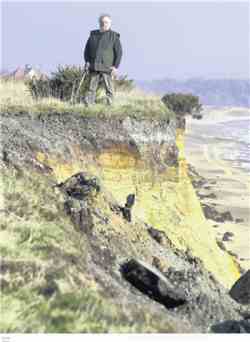
Peter Boggis v Natural England
There has been a long ongoing debate over the DIY right of Peter Boggis to attempt to safeguard his property from the sea in the absence of provided defences and the presence of (mis)Managed Retreat. A 'Google search' for 'Peter Boggis' on this website will cover the history, whilst an inspection of the Eastern Daily Press Forum pages shows many recent concerned comments.
Along with The Independent and the TV and Radio media The Eastern Daily Press of 5th December covers the story of this David over Goliath High Court victory in the following article written by Hayley Mace
Coastal defence campaigner wins High Court battle
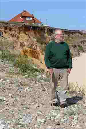
Peter Boggis pictured in 2007 with his eroded sea defences at Easton Bavents. Photo: Andy Darnell.
Retired engineer Peter Boggis today won a High Court battle for the right to attempt to save his clifftop home from falling into the North Sea. Mr Boggis has fought a long and expensive battle to protect homes in Easton Bavents, north of Southwold, from falling into the sea but Natural England, the body responsible for the country's natural features, have fought against his plans because they want to allow the fossil-bearing cliffs near his homes to erode 'for scientific reasons'.
The ruling was a victory for Mr Boggis, 77, who has spent thousands of pounds building his own sea defences out of 250,000 tonnes of compacted clay soils. He will not be able to resume maintenance of his sea defences until after a possible appeal by Natural England after today's ruling.
Mr Boggis said this morning: "Mr Justice Blair's judgment lifts a great shadow from my mind and gives hope for the future of those that live by the coast of Britain. We have lived a nightmare in recent years. Inconvenient or not to bureaucracy, the defence of the coast should not be walked away from. As I start again the maintenance and reconstruction of the simple sea defence of Easton Bavents, my neighbours will again be able to sleep without worry, instead of wondering if their homes will be lost in the next storm."
Mr Boggis was awarded 80pc of his costs and both parties were granted permission to appeal the ruling.
Malcolm Kerby of the Happisburgh based Coastal Concern Action Group, who has known Mr Boggis for several years and has shared a platform with him at public meetings in the past, said he was delighted by the victory. He said: "I would like to congratulate him. Peter Boggis is one of life's absolute gentlemen and a brave man indeed. "He has soldiered on against all the odds and he has not allowed the great machinery of government to intimidate him. It is a shot in the arm for all coastal dwellers."
Helen Phillips, chief executive of Natural England, said: "It is right that outstanding sites such as the Easton Bavents cliffs area are recognised for what they are and designated as areas of national conservation importance. "Natural England has a legal duty to do this. However, designation does not make it in any way inevitable that Mr Boggis will lose his home and we have no desire to see this happen. Regardless of whether the area is a SSSI or not, it remains open to Mr Boggis to seek the necessary legal permissions from the District Council and the Environment Agency for the sea defences he wishes to put in place. To date, Mr Boggis has not chosen to go pursue this route. We would encourage him to do so rather than present legal challenges that bring him no closer in determining whether his sea defences can be declared legal or not".
Loss of our precious RSPB bird sites to the sea
As well as the 11 hectares (the bulk of the reserve) set to be lost to the sea at RSPB's Titchwell Marsh and the loss of the shingle bank that will bring about first the salination then the loss of Cley Marshes (the biggest coastal marsh area in the country) we now learn of the threat to the loss of 60 acres of the world famous Minsmere RSPB Reserve to the sea.
RSPB have failed to heed the advice given them by MARINET and Sustainable Coastlines and instead have capitulated to the government's Managed Retreat policy. They wrote "We looked at the options for building up the beach. We believe you need to allow the coast to do what it wants to do to build up natural processes. We looked at building a sea wall but that doesn't really fit in with us because it's not very green having concrete everywhere".
David Green in The East Anglian Times of 19th November '08 reported the issue under.
Famous nature reserve will be lost to the sea
More than 60 acres of nature reserve on the Suffolk coast are to be abandoned to the North Sea. The Environment Agency will on Friday reveal plans to "withdraw maintenance" from an earth bank which protects part of the internationally important Minsmere nature reserve, between Dunwich and Sizewell.
Dunes protecting the bank have been severely eroded in recent years and officials believe that spending further money in trying to shore-up the defence cannot be justified - because the sea would soon break through. It will mean that more than 60 acres freshwater marsh at RSPB Minsmere, used by the rare bittern as well as marsh harriers, bearded tits and otters, will become more vulnerable to saltwater flooding.
While it does not believe that continued maintenance of the wall is economically or environmentally sustainable, the Environment Agency is also proposing to spend £1million in raising the height of another wall, known as Coney Wall or North Wall, which runs east west from the beach towards the Minsmere visitors centre. This wall protects the most important part of Minsmere - an area of more than 750 acres of freshwater habitat which is the main feeding and breeding ground of the bittern and many other species of bird. Agency officials believe that maintenance of this wall will protect the area for at least 50 years. However, both the agency and the RSPB acknowledge that much of Minsmere will be lost to the sea in the long term and the search has already started for compensatory habitat further inland. The Environment Agency is obliged under European Union law to replace such habitat.
The agency's "preferred option" for sea defence in the area - the culmination of five years work - is to go on public display at Leiston on Friday and people will have three months to give their response. Stuart Barbrook, the agency's project manager, said yesterday that a range of options had been examined for defending the area over the next 100 years. The RSPB, the National Trust, which owns Dunwich Heath to the north, and British Energy, owner of most of the Sizewell nuclear site to the south, had been consulted.
Among the options had been the construction of off-shore reefs and beach groynes - work which would cost many millions of pounds. A "do nothing" option would mean that the whole of the Minsmere reserve would be at risk of saltwater flooding," Mr Barbrook said. "Studies had shown that the most economically and environmentally sustainable option was to withdraw maintenance from the primary, beach-side wall and raise the height of a secondary wall, known as the Coney Bank. This would protect the area known as the Minsmere levels, low-lying marshland between Dunwich heath and the Sizewell nuclear site - at least for 50 years. During the last two winters there has been considerable damage at the north end of the Minsmere site. The dunes have taken a battering and have been breached. It is a real pressure point. Our preferred option means we are working more in line with nature," Mr Barbrook said. Ian Barthorpe, RSPB spokesman, said: "We support the scheme. Our view is that while we'd like to protect valuable habitats where feasible we accept than within 20 years this wall is likely to go."
The RSPB was working with the Environment Agency to identify alternative sites. Removal of maintenance in front of the North Marsh would mean the habitat would change as a result of saltwater incursion. But it would still be of value to wildlife on a coast where good marshland habitat is increasingly scarce.
Aggregate Dredging and The Crown Estate - facts and figures
The Crown Estate published a report on 7th November revealing the levels of aggregate dredged from the seabed and the revenue resulting from this. In (SIC(2007): part of 08.12) it revealed that the production of sand and gravel by dredging offshore contributes more than 20% of the material used for construction in England and Wales and that there were 'substantial exports'. In addition dredging supplies material for beach nourishment and regular contract fill, e.g. the Cardiff Bay Barrage and the Sizewell B nuclear power station.
The report states that the UK has the largest offshore dredging industry in Europe and one of the biggest in the world. Almost all dredging is done under licence from The Crown Estate, to which, as the major seabed minerals owner, the royalties collected for dredging are around £14m per year. In 2006 the total dredged was 24.3 million tonnes of which 13.4 million was landed at wharves in England and Wales for processing and use as construction aggregate; 6.7 million was landed at wharves on Continental Europe for construction aggregate whilst 4.2 million was used for beach replenishment and contract fill.
Based on 2006 production there are two figures for turnover. For that landed at the wharf (assuming £6 per tonne; BMAPA communication) is £146m out of the dock gate, and after processing (assuming £12 per tonne) it is £293m.
Prices in Continental Europe are about 30% lower than in the UK, and the value of beach recharge will be significantly lower than for processed material. Assuming the beach material is unprocessed and that all other material is processed, weighting according to the landed volumes for 2006 gives an estimated of turnover of £242m.
The Gross Value added can be roughly estimated using the combined use matrix in the UK Input-Output Tables for 2004, for the whole sector, at 0.47 of turnover. Hence, gross value added is estimated as £114m. Exports, based on the above calculations assuming the processed price of £12 per tonne are estimated at £56m.
The main area of offshore sand and gravel landings is the South East Region. One third of the South East region' primary aggregate requirements come from marine sources. The 10 million tonnes landed in the South East represents 75% of total UK marine aggregate landings (13.4 million tonnes), and 40% of total UK marine aggregate production (24.8 million tonnes, including exports and beach/contract fill). Of the 68 wharves in England and Wales, 35 are in the Thames and at South East ports as a third of all UK construction takes place in the south east.
South Wales is uniquely dependent on marine-dredged sand which accounts for 93 per cent of the market for all construction sand and 97 per cent of building sand supply. There are currently no landings in Scotland or Northern Ireland.
The report gives the trends and potential for future growth, and says that the supply of marine dredged sand and gravel for UK construction has been remarkably stable since the early 1970s. In most regions the annual volume landed is much less than the maximum allowed under the licence terms. Large construction projects in the South East can increase consumption (for example the Channel Tunnel Rail Link, and prospectively, the Thames Gateway port development). It further says that the demand for exports is expected to grow as Continental land supplies become exhausted.
On the demand for beach nourishment. it reports that material used varies from year to year depending on what projects are currently being undertaken. As Climate Change may increase the demand for protection against coastal flooding may in turn call for more soft engineered defences.
The principle user of UK landed sand and gravel is given as the construction industry, which gets about 21% of its sand and gravel supply in England and Wales from marine sources. In 2005, 79% of marine aggregate landings were used in the production of concrete and concreting products. Overall in 2004 31,000 people were employed in the manufacture of concrete products for construction purposes, and of ready-mix concrete. In 2005 the construction industry accounted for 6% (£63bn) of the total UK GDP.
Aggregates 2006
- Turnover £242m
- Gross value added £114m
- Exports £56m
- Number employed 1,670
Sources:
- The British Marine Aggregate Producers Association (Mark Russell) www.bmapa.org/key.htm
- The Office for National Statistics, Annual Abstract of Statistics, Table 22.19
- The strategic importance of the marine aggregate industry to the UK. Report prepared for BMAPA by the British Geological Survey 2007
Crown Estate keen for wave and tidal power development
'The Engineer' website has an item showing the interest of The Crown Estate in developing wave and tidal power in Pentland Firth entitled 'Crowning Glory'. It tells how they would like to see 700MW of new offshore wave and tidal power stations developed at the site by 2020 and that the proposed area is said to contain six of the top 10 sites in the UK for tidal power development, central to meeting Scottish government green energy targets.
The report in full may be seen in full at www.theengineer.co.uk/Articles/309031/Crowning+glory.htm
Dredging, Defence, the Dutch and UK Dithering
The North Norfolk News of 5th December '08 carries the following article telling of the lessons learned from a fact finding mission to The Netherlands comparing the Dutch restrictions on offshore aggregate dredging and protection from coastal erosion to those of Britain.
'Go Dutch' seen as coastal erosion answer
Coastal campaigners are urging officials to "go Dutch" and take a more positive attitude towards sea defences and compensation.
The call comes after a high-powered delegation went to the Netherlands to see how the low-lying neighbour across the North Sea tackles the problems shared with parts of the north Norfolk coast.
Local MP Norman Lamb, who chairs the all party parliamentary group on coastal and marine issues, said there was "a compelling logic" to applying the Dutch approach to the UK. And Coastal Concern Action Group co-ordinator Malcolm Kerby described the trip to Holland as "mind blowing". After an "illuminating and fascinating" meeting with government officials and scientists, Mr Lamb said the key differences were:
- The attitude to rising sea levels was one of working out how to deal with the situation rather than backing away from it. Mr Lamb added: "I asked them about a possible one metre rise in sea levels. They said 'we think we can maintain our defences to deal with that'."
- The standard of sea defences was much higher in Holland. While London was theoretically protected to withstand a one-in-1,000-year event, Dutch rural areas have a one-in-1,250-year event protection, while the urban areas rose to one in 10,000 years.
- Compensation for the loss of Dutch homes to the sea or as a result of projects designed to improve defences was automatic and rested not on an assumed responsibility to home and business owners rather than legislation.
- The Dutch ban dredging in waters shallower than 20 metres and take a longer term view of the potential impact on erosion rates than the UK government does. The Dutch experts agreed the UK should create a more robust system of assessing dredging licences, as well as conducting more research into the impacts.
Mr Lamb said: "It was so stark how different the mindset is. One can understand how the approach has come to be different. A substantial amount of their population and economic engine is below sea level and their history has been dominated by the subject of land reclamation. But whatever the different culture and history, the overarching point is that the way they treat people in their communities is completely different and there are massive lessons to be learned from that."
Campaigners are battling against emerging government-led policies to resist sea defence funding in favour of evolving a more natural coastline, a reluctance to value the loss of properties and community, and failure to provide "social justice" through compensation. They have been heartened recently by a more positive approach to both defence and compensation from Lord Smith, chairman of the Environment Agency which controls the nation's coastline.
But Mr Kerby said getting the Dutch view at first hand had been "mind blowing". He added: "They looked at us quizzically when we asked about what legislation they base their compensation scheme on. It's simply de rigueur, the right thing to do. There is no need to resort to law. There is a tangible feeling of positivity over there, it's poles apart from this country. The difference is staggering."
Impending demise of Titchwell Bird Reserve
'RSPB to abandon sea defences', an article appearing in the Eastern Daily press of 1st December gives that RSPB officials have applied for planning permission to 'realign' the sea defences protecting their reserve from loss to the sea at Titchwell Marsh. (Please refer to our earlier news of this to be found under 'Abandoning the best of Norfolk to the Sea')
Despite sound advice from MARINET and Sustainable Coastlines on the means of saving the area the RSPB intend to go ahead with their own form of Managed Retreat in the assumed hope that this will serve to protect further inland freshwater lagoons.
Fears over Norfolk world heritage site listing
That's the title of an item in the Eastern Daily Press of 3rd December '08 written by Ed Foss. It tells how The Wash and North Norfolk Coast that aspired to a leading list of the most prestigious international heritage sites may be about to be reversed, as the government has raised a series of questions in a new consultation process, with concern raised about the exact value of the designation and whether such sites should be nominated.
A cost benefit analysis performed by Price WaterhouseCoopers has claimed that the status does not provide any additional statutory protection and that the benefits of tourism and regeneration have been overstated.
But for what it is worth, there is to be consultation on the proposal, which will run for 12 weeks until February 25. For this consulation document and for further information please log on to www.culture.gov.uk
Perhaps this is another round round of the government attempting to avoiding further come backs resulting from their 'Managed Retreat' policy of allowing such precious areas to be abandoned to sea? The North Norfolk Coast was first put forward in 1999 as one of 27 in the UK World Heritage Sites tentative list, the usual precursor to full designation.
Defra consulting on revision of Regulations governing Dredging in Harbours
Defra is revising the Regulations which govern the need for Environmental Impact Assessments on the dredging of material from harbours, and whether the Port of London Authority should be an appropriate authority for considering EIAs. This public consultation closes on 19th February 2009, and full details can be seen at www.defra.gov.uk/corporate/consult/marine-works/index.htm
Marine ALSF publish marine dredging research
The Marine ALSF has published the findings of over £4 million of research related to marine aggregate dredging for projects undertaken during FY2007/08 (administered by the MEPF and English Heritage) based on the proceedings of a two-day conference held in Essex in February 2008. The published document "Science Review 2008" also contains details of those projects commissioned by the Marine ALSF in FY08/09 under Round 3 of the Fund (2008-2011). Further details on the new projects will be available on this website shortly. An electronic version of this document can be downloaded.
Note: As the printed version of the Science Review also contains a CD of project presentations from the 2008 February Conference, those wishing for a copy of this CD should contact the MEPF Secretariat at secretariat@alsf-mepf.org.uk
Report of Finnish Coastal Environment Survey now available
The report of Finnish Environment Institute 21 international survey into the significance of ecological thresholds in coastal areas can now be seen as a PDF file.
The Conclusion to the Report states (inter alia):
"The results provide a reminder that the management of coastal areas is difficult because many fundamental concepts and issues are viewed and understood differently. The differences in the ways issues and problems are framed are likely to hamper management actions and create confusion, thus creating the conditions that most regard as unacceptable, i.e. the inability of societies to avoid the unwanted passing of ecological thresholds."
This may provide an important clue to the reason why campaigns meet with so much resistance, as the 'science' clearly is not nearly as objective in its assessments as we commonly assume.
Prof. Mikael Hildén and co-workers Jari Lyytimäki, Zelealem Aberra and Matti Lindholm thanks the 300 participants who responded.
Growing concerns over ocean acidification due to CO2
Two recently published studies highlight the growing impact of ocean acidification - the lowering of the pH of seawater due to the increasing absorption of large amounts of carbon dioxide - in the Caribbean and the Southern Ocean.
A paper by scientists from NOAA (National Oceanic and Atmospheric Administration and the University of Miami's Rosenstiel School of Marine and Atmospheric Science) confirms significant ocean acidification across much of the Caribbean and Gulf of Mexico.
And a second paper by scientists from the University of New South Wales ( Australia ) and the Centre for Australian Weather and Climate Research and Antarctic Climate & Ecosystems Cooperative Research Centre, concludes that the Southern Ocean will acidify past a critical tipping point when atmospheric CO2 levels pass 450 ppm, projected to occur within 30 years at most.
At this point of aragonite undersaturation, the shells of sea creatures will start to dissolve. Previous estimates found that this dissolution point for shells in the Southern Ocean would occur after atmospheric carbon dioxide concentrations reached 550 ppm, which is projected to occur in the latter part of the century.
Since the beginning of the industrial era, the oceans have absorbed about a third of all anthropogenic carbon dioxide emissions released into the air - this has served as a carbon sink, and retarded some of the warming that otherwise would have occurred.
Atmospheric CO2 reacts with seawater to form carbonic acid (H2CO3). Increasing the amount of CO2 dissolved in the ocean lowers the pH, decreases the availability of carbonate (CO32-) ions, and lowers the saturation state of the major shell-forming carbonate minerals such as aragonite. Carbonate ions are building blocks for the calcium carbonate (e.g. aragonite, calcite) that many marine organisms use to grow their skeletons and create coral reef structures.
With increasing carbon dioxide in seawater, shellfish and corals cannot absorb enough calcium carbonate to build strong skeletons and shells. The greater acidity slows the growth and even dissolves ocean plant and animal shells.
Ocean acidification has been called the 'silent climate change issue' because it gets far less press than global warming, sea level rise and rainfall changes. Yet for marine systems, it could end up being the most important consequence of industrial pollution of all because it risks dissolving coral reefs and undermining the food chain upon which the world's fisheries and marine mammals depend.
Source and for full details of this item: Green Car Congress
Increasing Demand for Aggregate
The Construction Industry Research & Information Association (CIRIA) in the UK is in the process of fundraising to update its respected publication, the 1996 CIRIA Beach Management Manual (R153). An Environment Agency scoping study was completed in 2007 identifying a number of changes and additions to be made to the existing manual to increase its uptake and use. These included targeting beach managers who are increasingly non-engineers more involved with the amenity aspects of a beach rather than coastal defence.
The report 'Update of Beach Management Manual planned' can be seen in New Publications - June 6, 2008 or on the Internet at www.sandandgravel.com/news/article.asp?v1=11026
Another of CIRIA's other works/projects include:
Beach recharge materials - demand and resources (R154)
Author(s): B Humphreys, T Coates, M Watkiss and D Harrison
Date: 1996
ISBN (13 digit): 978-0-86017-439-4
ISBN: 0-86017-439-5
Pages: 176
Publisher: CIRIA
Description:
There is increasing pressure on the UK's marine sand and gravel resources. Planning constraints are tending to restrict the extraction of sand and gravel resources on land, while the exploitation of marine resources in encouraged, subject to environmental safeguards. In addition to the demand for aggregates from the construction industry, there is an increasing demand for marine sand and gravel for beach recharge in coastal defence schemes. This report provides quantitative estimates of the national demand for beach recharge material and of the resources suitable to meet demand over the next 20 years. This information is presented regionally: for the south and east coasts, and the coasts of Wales and western England respectively. The results are of particular relevance in the determination of policy regarding coastal defence and minerals planning, and provide coastal authorities and engineers with information on the resource options for recharge materials. The report considers the potential for the use of beach recharge of materials other than marine sand and gravel, such as navigational dredgings. While some of these alternative materials may offer attractive local or opportunistic options, they are unlikely to satisfy the requirements of most major schemes.
Crown Estate Socio-Economic Report on Marine Aggregate Dredging
On 6th November 2008 the Crown Estate published a new report on the levels of marine dredging, the staffing of the industry and the financial contribution derived and resulting from the activity. Whilst we have reproduced that relating to the aggregates section, in full it can be seen here.
The production of sand and gravel by dredging offshore contributes more than 20% of the material used for construction in England and Wales. There are substantial exports. In addition dredging supplies material for beach nourishment and regular contract fill (for example Cardiff Bay Barrage, and Sizewell B nuclear power station).
Most processing takes place at the landing wharves. The UK has the largest offshore dredging industry in Europe and one of the biggest in the world. Almost all dredging is done under licence from The Crown Estate, which is the major seabed minerals owner: royalties collected for dredging are around £14m per year.
Turnover In 2006
The total dredged was 24.3 million tonnes of which 13.4 million was landed at wharves in England and Wales for use as construction aggregate; 6.7 million was landed at wharves on Continental Europe for construction aggregate; and 4.2 million was used for beach replenishment and contract fill. Based on 2006 production there are two figures for turnover.
Landed at the wharf
Assuming £6 per tonne; BMAPA communication is £146m; Out of the dock gate after processing (assuming £12 per tonne) is £293m. Prices in Continental Europe are about 30% lower than in the UK, and the value of beach recharge will be significantly lower than for processed material. Assuming the beach material is unprocessed and that all other material is processed, weighting according to the landed volumes for 2006 gives an estimated of turnover of £242m.
Gross Value Added
This can be roughly estimated using the combined use matrix in the UK Input-Output Tables for 2004, for the whole sector, at 0.47 of turnover. Hence, gross value added is estimated as £114m.
Exports
Based on the above calculations, assuming the processed £12 per tonne, these are estimated at £56m.
Numbers employed
The fleet of some 27 marine aggregate dredgers has about 475 staff and there is also 140 management staff. The wharves in the UK employ a further 500 people (140 on the Continent) for operations and processing. A further 544 are employed as UK hauliers delivering to the point of end use (160 on the Continent). Excluding the continental employees, the total is 1,670.
Activity by region
The main area of offshore sand and gravel landings is the South East Region. One third of the South East region' primary aggregate requirements come from marine sources. The 10 million tonnes landed in the South East represents 75% of total UK marine aggregate landings (13.4 million tonnes), and 40% of total UK marine aggregate production (24.8 million tonnes, including exports and beach/contract fill). Of the 68 wharves in England and Wales, 35 are in the Thames and at South East ports. A third of all UK construction takes place in the south east, where marine aggregate supplies are so significant. South Wales is uniquely dependent on marine-dredged sand which accounts for 93 per cent of the market for all construction sand and 97 per cent of building sand supply. There are currently no landings in Scotland or Northern Ireland.
Trends and potential for future growth
The supply of marine dredged sand and gravel for UK construction has been remarkably stable since the early 1970s. See Figure 6. In most regions the annual volume landed is much less than the maximum allowed under the license terms. Large construction projects in the South East can increase consumption (for example the Channel Tunnel Rail Link, and prospectively, the Thames Gateway port development). Demand for exports is expected to grow as Continental land supplies become exhausted. Demand for beach nourishment material varies from year to year depending on what projects are currently being undertaken. Climate change may increase the demand for protection against coastal flooding, which in turn may call for more soft engineered defences.
Related impacts / consequences in the UK economy
The principle user of UK landed sand and gravel is the construction industry, which gets about 21% of its sand and gravel supply in England and Wales from marine sources. In 2005, 79% of marine aggregate landings were used in the production of concrete and concreting products. Overall in 2004 31,000 people were employed in the manufacture of concrete products for construction purposes,and of ready-mix concrete. In 2005 the construction industry accounted for 6% (£63bn) of the total UK GDP.
- Aggregates 2006
- Turnover £242m
- Gross value added £114m
- Exports £56m
- Number employed 1,670
Sources
The British Marine Aggregate Producers Association (Mark Russell) www.bmapa.org
The Office for National Statistics, Annual Abstract of Statistics, Table 22.19
The strategic importance of the marine aggregate industry to the UK.
Report prepared for BMAPA by the British Geological Survey. 2007
One-third of UK beaches pose health risk to bathers
The Marine Conservation Society (MCS) has reported that more than one in three of Britain's beaches now pose a health risk for bathers because of water pollution. The MCS claim is made on the basis of bathing water monitoring data for 2008 released by Defra which shows that 35% (207) out of Britain's 587 officially designated beaches failed this year to meet the "Guideline Standard" of the EU Bathing Water Directive, 76/160/EEC.
As a result, MCS is renewing its call for an expansion of the sewer system to handle large volumes of storm water, for further action to improved Britain's combined sewer overflow network, and for a reduction in animal waste run-off from agricultural land.
Thomas Bell, MCS Coastal Pollution Officer, says "These latest results reflect a worrying trend toward worsening pollution of Britain's beaches. There was a high point in 2006 when 76% of beaches had good water quality, but long bouts of heavy rain over the last two summers have swept pollutants like farm fertilizer, street debris and animal waste directly from the land into rivers and the sea."
"The coast" Thomas Bell continues, "is also ringed by a network of combined sewer overflows (CSOs) which discharge a mixture of storm water and raw sewage into the sea whenever the sewers flood. MCS believes that this network needs significant new investment to reduce its pollution impact, as well as new measure to tackle storm run-off from farm-land and city streets." Thomas Bell also observes "Not all beaches are affected by this problem. The results show good standards on roughly two thirds of beaches, but coastal pollution has worsened markedly from a high point in 2006 and the problem for swimmers is knowing which beaches have suffered and when."
For further details, see www.mcsuk.org/newsevents/press_view/251
Defra study continues into marine disposal of contaminated dredge sediments
Defra has an ongoing study to develop a strategy to address contaminated sediment issues arising from proposed dredging for socioeconomic reasons (i.e. economic development). This study does not involve proposed remedial dredging of sediments deemed to pose a risk if left in place. The focus of the study is on disposal options. The project is not intended to provide a framework for evaluating, permitting and controlling the dredging of contaminated sediments but instead focuses on the disposal and or treatment of contaminated sediment.
The Defra study has six main tasks. Firstly, characterising the issue and delivering a national database of UK contaminated dredge marine sediments (CDMS). Secondly, exploring the liability and "polluter pays" issues, and thirdly, identifying the existing relevant legislative and regulatory barriers in this regard. Fourthly, exploring the methods currently being used to prevent sediment becoming contaminated in the first place, and fifthly, establishing the current best practice for disposal and treatment options for those sediments that are contaminated. And sixthly, identifying the future R&D needs related to CDMS.
The first 18 months of the study, it is claimed, have been involved with the building of a database of contaminated dredge marine sediments, and the project from now on will be consulting stakeholders, end-user-groups and commercial industry.
For further details, see the project website www.defra.gov.uk/marine/sediment/index.htm
Sizewell site's flooding 'danger'
The following article is from the East Anglian Times of 22nd November 2008 but is unfortunately not available on-line.
Campaign group issues formal reply to Government consultation
The unstable nature of the East Anglia coast and the danger of flooding make the Sizewell site unsuitable for a further nuclear power station, according to a campaign group in its formal response to a Government consultation.
The Shut Down Sizewell Campaign suggests that there is a high level of concern about the vulnerability of the nuclear site to attack by the North Sea. It claims that dredging operations off the region's coast are increasing the risk by aggravating coastal erosion.
A twin reactor Sizewell C - costing £6billion - is being planned and is likely to be the first of a series of new nuclear plants. The other shortlisted sites are at Bradwell, Essex, Hinkley Point, Somerset and Dungerness, Kent.
The Department for Business, Enterprise and Regulatory Reform (BERR) has issued its assessment of the criteria which will be used to judge the suitability of sites for new nuclear power station planned to replace old generation plant and as part of the UK response to global warming. It suggests that the risk of floods, tidal surges and coastal erosion will not be primary considerations.
Peter Lanyon, who has responded to the Government consultation on behalf of the Shut Down Sizewell Campaign, claims that Met Office predictions about sea level rise are not in tune with the latest findings of the International Panel on Climate Change.
"For these reasons it is clearly inappropriate to site nuclear stations that will be vulnerable for well over a hundred years anywhere near an eroding coastline. So flooding, tsunamis, storm damage and coastal processes should be exclusionary criteria and they should automatically rule out Sizewell as a possible site," Mr Lanyon states in his letter to BERR.
British Energy has commissioned a report from consultants which suggests that the Sizewell C site can be protected from increased flood risk by engineering means. The company believes there is no climate change reason not to go ahead with the building of new nuclear power stations. The plants need to be near the coast because of the demand for large volumes of cooling water.
World Conference on marine biodiversity recognises the importance of Marine Reserves
The first World Conference on marine biodiversity organised by marine scientists was held in Valencia, Spain, 11th to 15th November 2008.
The Conference resulted in the Valencia Declaration and observed that despite wide concern over the health of marine systems and of global fisheries, less than one percent of the oceans are currently afforded protection.
The scientists believe that marine protected areas (MPAs) are a powerful tool to sustain the viability of marine biodiversity. Existing studies indicate that networks of well-managed MPAs can make ecosystems more resilient to external threats like eutrophication or climate change, can protect valuable habitats, and can support species that use these habitats for feeding or breeding.
The conference concluded that there is overwhelming scientific evidence that marine biodiversity and marine ecosystems are essential to the functioning of our biosphere and hence to human well-being, and found that the pace and scale of human-caused changes occurring in the oceans and the impact of these changes on marine biodiversity and ecosystems are cause for grave concern.
The scientists are of the firm belief that when effectively designed, managed and enforced, marine protected areas can deliver many ecological and socio-economic benefits. To be effective, networks of marine protected areas must be ecologically coherent and should be an essential part of ocean management plans.
A warning was also given that geo-engineering of the oceans to mitigate climate change may deliver negative impacts to marine ecosystems.
An important observation was made that deep sea ecosystems differ significantly from coastal ones, with the dynamics of most deep-sea fish stocks being very fragile and slow to recover once damaged. Therefore they should be approached with an exceptionally high degree of precaution.
Consequently, the Conference urged that ecologically coherent networks of marine protected areas throughout the oceans be developed at an urgent and accelerated pace using existing scientific data and understanding, and that research efforts to improve understanding of marine biodiversity be enhanced in order to provide the knowledge necessary to underpin adaptive management.
Defra publishes guide to marine licensing under the Marine Bill
The booklet published by Defra, titled "Managing our marine resources - licensing under the Marine Bill" explains the changes the UK Government are proposing to make to the marine licensing and enforcement systems through the Marine Bill, and how these changes will work in practice.
For further details, see here.
Peter Boggis versus Environment Agency
The ongoing battle between Peter Boggis and the Environment Agency has been reported regularly in our website pages in the past. (See 'Unusual winds and groyne problems for cliff man' item from the Lowestoft Journal of 15th September 2007 placed under our archives on the MARINET website.)
The issue has now reached the High Court. Radio, TV, the Eastern Daily Press as well as national newspapers are all carrying the news. Under the heading 'Modern 'Canute' fights the sea - and the law - to save home' the story was in The Independent of Thursday 20th November '08.
Our local Eastern Daily Press reporter Alasdair McGregor wrote it up on 18th November '08 in an article entitled 'High court challenge over sea defences'. Further detail appeared as 'Natural England defends erosion plans' in the same paper the following day 19th November 2008.
The result of this case will be eagerly awaited by the many who hope to save their homes and businesses and living due to the threat imposed by failure to defend many areas from erosion and flooding because of the governments 'Managed Retreat' a.k.a. 'Making Room for Water' policy. The outcome will not be known until just after Christmas as Judgement is reserved. Then hopefully a much hoped for Christmas present will arrive.
The High Court case is being capably fought by MARINET member Lawyer Peter Scott, who has kindly provided MARINET with a copy of the grounds of the challenge in detail. As judgement is reserved, it would best be that it did not appear on our website, but, as many in a similar situation to Peter Boggis might well wish to see it, MARINET can send a copy of the grounds of challenge to those who request it by an e-mail sent to pat.gowen@ntlworld.com providing their e-mail address.
Peter is doing what the Environment Agency should be doing, that is defending people, their property and their livelihood, as happens in some of the more civilised countries of this world. As it is, the EA do not oppose offshore dredging, the main cause of the erosion, and the government have done very little in meaningful terms to counter the sea rise brought about by ever rising carbon dioxide emmissions. The case rests here.
UK Bathing Water Quality worse in 2008
Recent results published by Defra and the Environment Agency for bathing water quality in 2008 show that the mandatory quality standard (the legally enforceable standard) was, according to Defra, met by 95.8% of UK beaches in 2008 compared to 96.5% in 2007.
In respect of the guideline standard (not legally enforceable, but a recommended standard for beaches and their bathing waters) Defra claim that 63.9% of UK beaches met this standard in 2008 compared to 70.8% in 2007.
When considering England alone, Defra assert that 398 out of the 414 English beaches met the mandatory standard. Thus, 16 English bathing waters failed the mandatory standard. Defra commented "Exceptionally wet weather in July, August and September has resulted in the slightly lower standard of the water this year. Ten of the 16 failing bathing waters are in the South West, which was hit hard by heavy rainfall during the summer."
Heavy or persistent rainfall means that sewers become overloaded, and thus have to make emergency discharges of untreated sewage either direct to sea in the case of coastal areas, or into rivers for inland areas. Contaminated inland rivers eventually discharge their pollutant load to sea.
Full results for individual beaches and bathing waters, including Wales, Scotland and Northern Ireland, can be viewed at the Defra website.
MARINET observes that the Government's claim that 95.8% of UK beaches have met the mandatory standard in 2008 is misleading. This is because the monitoring has failed to test for the presence of salmonella and enteroviruses at virtually all bathing waters in the UK. This monitoring is a mandatory requirement if there is evidence of sewage being present. Given that only 63.9% of UK bathing waters passed the guideline standard in 2008 (due to the presence of sewage), there is obviously a need for the proven absence of salmonella and enteroviruses to be monitored. MARINET believes that the UK Government is in breach of the Bathing Water Regulations for failing to monitor for salmonella and enteroviruses in most UK bathing waters.
The types of pathogens present in sea water as a result of sewage discharges are numerous. The testing regime to comply with the mandatory standard of the EC Bathing Water Directive, 76/160/EEC, requires testing for salmonella and enteroviruses, and requires that none are present. The types of pathogens that this sampling is looking for and the diseases they can cause are as follows:-
1) Bacterial Pathogens
| Pathogen | Disease Associated |
| Campylobacter | Gastroenteritis |
| Chlostridium Botulinis | Botulism |
| Certain Coliforms | Diarrhoea & Blood Poisoning |
| E.Coli-0157 | Gastroenteritis & Renal Failure |
| Leptospira | Leptospirosis (Weill's Disease) |
| Proteus types | Diarrhoea |
| Psuedomonas | Localised Infection |
| Salmonella Typhi | Typhoid & other enteric fevers |
| Other Salmonella serotypes | Food Poisoning Symptoms |
| Shigella (various) | Bacterial Dysentery |
| Tubercle bacilli | Tuberculosis |
| Yersinia enterococci | Gastroenteritis |
2) Viral Pathogens
| Pathogen | Disease Associated |
| Adenovirus | Acute Haemorrhagic Cystitis |
| Cocksackie | Aseptic Meningitis |
| Echovirus | Aseptic Meningitis |
| Epidemic Gastroenteritis B | Gastroenteritis |
| Infectious Hepatitis | Liver Inflammation |
| Norwalkvirus | Gastroenteritis |
| Poliovirus | Poliomyelitis & Meningitis |
| Small Round Viruses (SRVs) | Gastroenteritis |
Reference:- Memoranda from Pat Gowen, Norwich & Broadland Friends of the Earth to the House of Commons 1997-98 Environment, Transport and Regional Affairs Committee on 'Sewage Treatment and Disposal', pages 179 - 188, published 28th October 1997.Stationary Office, London, HC266-III.
Additional to these are parasites that also can damage health, such as:-
3) Parasites
| Parasite | Disease Associated |
| Balantidium Coli | Balantidial Dysentery |
| Cryptosporidium | Epidemic Diarrhoea |
| Entamoeba Histolyticad | Amoebic Dysentery |
| Giardia Lamblia | Diarrhoea |
| Intestinal Flukes | Intestinal Infections |
| Isopora hominus | Coccidosis |
| Liver Flukes | Liver infection |
| Pinworm (eggs) | Ascariasis |
| Tapeworms | Tapeworm infestation |
Accordingly, MARINET believes that there is a clear need for the salmonella and enterovirus monitoring to occur in UK bathing waters. Claims by the UK Government that UK bathing waters are clean and safe, and that nearly 96% comply with the mandatory standard, must therefore be viewed with some caution.
Using Defra's methods (i.e. excluding salmonella and enterovirus monitoring), the bathing waters in England that failed the mandatory standard in 2008 were:
- Staithes in the North East
- Aldingham, Allonby and Bardsea in the North West
- Coombe Martin, East Looe, Exmouth, Instow, Plymouth Hoe East, Plymouth Hoe West, Porthluney, Readymoney, Rock and Seaton (Cornwall) in the South West
- Sandgate in the Southern region
- one inland bathing water, Windermere Millerground Landing in the North West
- one failure in Wales
- seven failures in Scotland
- one failure in Northern Ireland
Defra claims that bathing water quality has improved over the past decade. Therefore we reproduce here the figures published by Defra in this context, firstly in respect of the mandatory standard, and then in respect of the guideline standard (Note: these figure do not include monitoring for salmonella and enteroviruses).
The table below shows percentage compliance with the mandatory standards for total and faecal coliforms in England only and in the UK over the last decade.
| Year | 99 | 00 | 01 | 02 | 03 | 04 | 05 | 06 | 07 | 08 |
| England % compliance | 90.3 | 94.3 | 97.8 | 98.5 | 98.8 | 98.3 | 98.8 | 99.5 | 97.8 | 96.1 |
| UK % compliance | 91.4 | 94.1 | 95.3 | 97.8 | 98.4 | 97.7 | 98.4 | 99.5 | 96.5 | 95.8 |
The table below shows percentage compliance with the guideline standards for total coliforms, faecal coliforms, and faecal streptococci in England only and in the UK over the last decade.
| Year | 99 | 00 | 01 | 02 | 03 | 04 | 05 | 06 | 07 | 08 |
| England % compliance | 37.5 | 44.4 | 59.6 | 69.8 | 73.5 | 67.1 | 73.7 | 75.1 | 72.5 | 65.7 |
| UK % compliance | 41.8 | 44.6 | 57.3 | 67.6 | 74.2 | 67.9 | 74.0 | 75.0 | 70.8 | 63.9 |
Source: Defra website
For a full analysis of the 2007 bathing water results for the UK , see the MARINET website www.marinet.org.uk/ukbw.html#gbg).
Another nature reserve condemned to the sea
In an article entitled 'Area of nature reserve to be surrendered to the sea' the Eastern Daily Press of 19th November reports that on top of the the precious Holme, Cley and Salthouse Wildlife Sites, the 60 acre Minsmere nature reserve is to be consigned to the sea, as the Environment Agency consider it not to be financially viable to defend.
Call for a ban on the shooting of seals by Scottish salmon producers
Following the recent announcement by the Sea Mammal Research Unit at St Andrews University, Scotland, that seal populations in Scottish waters are in a serious unexplained decline (See the following article for more information on the decline in British seal populations), the Seal Protection Action Group (www.sealaction.org) is calling for an immediate and comprehensive ban on the killing of seals by Scottish salmon producers and other fisheries interests in Scotland and the United Kingdom.
Andy Ottaway, Seal Protection Action Group, says "In March of last year the Scottish Executive introduced an emergency conservation order [ The Conservation of Seals (Scotland) Order 2007 SSI/2007/126 ] for common seals in Shetland, Orkney and an area of the east coast of Scotland between Stonehaven and Dunbar, 'to offer additional protection to a sensitive and potentially vulnerable common seal population in these three areas following recent reductions in common seal numbers there'. Unfortunately this conservation order does not preclude the shooting of seals in the name of fisheries protection."
"At present", says Andy Ottaway, "both common and grey seals are managed under the Conservation of Seals Act (1970). However, this outdated legislation effectively provides no protection against shooting except during the breeding seasons or in areas with year round conservation orders. Even in these cases there are still provisions which mean seals can be legally shot. In particular, the shooting of seals by the aquaculture industry is totally unjustified. We believe it is perfectly possible to protect farmed fish and equipment by non-lethal means, such as properly tensioned nets and other measures. In addition, there is no scientific evidence that shooting individual seals that happen to be observed close to a fish farm can provide any reliable protection against predator damage."
"It is likely" continues Andy Ottaway, "that thousands of seals are shot in Scottish waters each year and yet there is no legal requirement to record the numbers killed. Although shooting has not been implicated as a primary cause for the alarming decline in common seals, and there is certainly evidence of environmental change from warming waters, we believe that deliberate killing has played its part, can only exacerbate the situation and must be stopped, at least as a precautionary measure."
Dramatic unexplained decline in British seal populations

Common seal, phoca vitulina. Photograph: Rex Features
Scientists at the Sea Mammals Research Unit at St Andrew's University, Scotland, have warned of significant and serious changes in the seas around Britain after detecting a steep and "frightening" fall in the numbers of common seals around the coast. In the worst affected areas, such as the Orkney islands, the numbers of common seals are falling by 10% a year, and have dropped by as much as half in the past six years. Along the Argyll coast, from Oban to the Mull of Kintyre, the numbers fell by a quarter last year.
Ian Boyd, a professor with the Sea Mammals Research Unit, said it was as if the entire population had stopped breeding and that the cause was baffling scientists. "We just don't know," he said. "Our collective view is that there's some large-scale process going on in the northern North Sea which is driving down seal numbers. We're seeing a massive decline. It's quite a frightening decline because these populations don't change as quickly as that under normal circumstances. This is very abnormal. To give you an idea of the level of abnormality, the rates of decline are equivalent to these populations producing no offspring for five or six years."
The steep declines mirrors other crises in the marine environment. Biologists have reported plummeting sea bird populations, with falls of a third in numbers of puffins on the Farne islands off the Northumberland coast, and the Isle of May at the Firth of Forth, as well as declines in food sources for mammals and birds, such as sand eels. At the same time, warmer-water animals from plankton through to large fish are moving north.
Ian Boyd said it was too early to say whether climate change was directly connected to the collapse of seal populations. He said his unit and other marine biologists were investigating a number of possibilities, including the theory that common seals - also known as harbour seals - were up against stiff competition from the larger, more robust grey seals for increasingly scarce food supplies. Some studies suggested that killer whales, now hunting in larger numbers around Orkney and Shetland, were killing seals at pupping time. People could be illegally shooting the seals in fish-farming areas and at inshore fishing grounds. But Boyd said these problems were localised and could not explain the UK-wide declines. The causes, he believed, were likely to be complex.
The latest figures show that last year common seal numbers fell from 4,256 to 3,379 in Orkney, from 1,056 to 800 along the eastern coast of the northern Highlands, from 113 to 102 in the north-east, in Grampian, and from 6,702 to 4,732 on the west coast from Oban to the Mull of Kintyre. There was also a fall, from 445 to 215, in Fife, and by nearly half in the smaller populations around Lothian and Dumfries and Galloway.
In English waters, smaller populations at the nature reserves at Blakeney Point, in Norfolk, and Donna Nook, in Lincolnshire, also fell sharply. Some areas have shown increases, particularly the Wash, where numbers rose from 1,695 to 2,162 last year. But total numbers across the UK fell by 12% last year at the 13 sites where counts were made over two years - down by 3,120 animals to 23,277, a drop that early figures suggest has continued this year.
Ian Boyd said that, by contrast, there had been "rapid growth" in the nearest population on the continent, in the Wadden Sea, off the Dutch, German and Danish coasts. "We ought to be worried because these animals are at the top of the marine food chain and are in a sense bellwethers of what's going on in the marine environment," he said. "Quite apart from the fact that they're charismatic species, they're indicators of the level of robustness that there is within the marine environment, and if we're seeing populations declining rapidly like this, it's got to ring alarm bells."
Source: The Guardian 20th October 2008
Eurosion Paper on Essex Estuarial Erosion
Distinct from the 29th October 2005 EUROSION Report (at www.marinet.org.uk/mad/scientificstudies.html#eep) which the powers that be attempted to delete that content showing the North Norfolk Coast erosion being due to Offshore Aggregate Dredging, another EUROSION report has recently been unearthed by Maike of Coastal Essex FoE g.petri@telinco.co.uk
This relates to the serious ongoing estuarial coastal loss of Essex, and (among other contributors) shows that offshore dredging is implicated in the loss of sediment supply, hence the erosion. See paper here.
Wave Power takes a step ahead
The Eastern Daily Press of 8th November '08 published the following item by Victoria Nicholls describing the forthcoming installation test of a Trident wavepower generator off the Suffolk Coast.

The revolutionary wave power machine
Wave power machine unveiled in Southwold
The inventor of an electricity generator which will harness wave power off the Southwold coast unveiled his model yesterday. And if it proves its worth the Trident generator could lead the way for projects like it around Britain's coastline.
The generator will be moored five miles offshore from early next year for trials. Floats, which move up and down with the waves, will drive generators which convert the motion into electricity, which is piped via sub-sea cables onshore and linked to the national grid. The Trident generator, the first of its kind ever to be built, will be left in the North Sea initially for three months, before it is converted into a full-size model.
Its inventor Hugh-Peter Kelly said: "Wave energy has been neglected. It is the hardest but most rewarding form of renewable energy. Forty percent of our entire national energy needs for electricity can come from harnessing wave power around the UK."
Trident Energy, which is based in Southend, commissioned marine engineers Small & Co in, Lowestoft to build the framework rig, which is in the final stages of construction.
Energy and climate change minister Lord Hunt, who visited the rig before opening of the Orbis Energy centre at Ness Point, said: "I think it's a very exciting project by Trident. It has great potential for developing experts and developing much more renewable energy. The test will be to scale it up."
Hull asks for an investigation into Offshore Dredging
The Hull and East Riding Mail reported on November 3rd under 'Calls for investigation into coastal erosion' the following item.
A fresh call will be made for the Government to carry out an investigation into whether offshore dredging has contributed to large losses of land on the East Riding coast. In the past year, unprecedented chunks of cliff measuring almost three times the length of a double-decker bus have disappeared into the sea.
East Riding Council wrote to the Government requesting an independent study into whether offshore dredging is a factor in the high rates of erosion.
However, officials from the Department for Environment, Food and Rural Affairs (Defra) say a series of studies have already been carried out and no link was made between the erosion and dredging. Monitoring of the region's coastal erosion has shown 89ft (27m) sections of land have vanished to the north and south of Withernsea.
East Riding Council have invited new Environment Agency chairman, Lord Smith of Finsbury, to see first hand the effects of coastal erosion and to ask for a research study to be commissioned.
According to the latest figures, 4.48 million tons of aggregates were dredged from the Humber region in the past year. Dredging takes place in a number of areas, including sites near Easington and Spurn Point.
A Defra spokesman said: "All dredging applications are rigorously assessed for any adverse effects and for potential contribution to erosion. There is no evidence that authorised aggregate dredging has had any impact on the coast."
Derek Crook lost his home in Seaside Lane, Tunstall, near Withernsea, to coastal erosion last year and now lives in a caravan yards from the cliff edge. The 68-year-old said: "I do believe dredging has a big impact on coastal erosion. It is not allowed on the continent and it seems crackers we allow this to go on around our coast.
Help from Europe?
In an article entitled "Bid for EU flood zone funding" the Lowestoft Journal of 3rd November reports a bid to secure European funding to protect homes and land around a north Suffolk estuary which has attracted the support of decision-makers in the flood risk zone.
For the full details please visit here.
UK Government grants aggregate dredging licence for Area 481 on the east coast
The Government has granted an aggregate dredging licence for Area 481, known as Inner Dowsing. Hardly a surprise really, as they always grant such applications regardless of evidence and reasons as to why they should not.
Opposition came from numerous sources. The King's Lynn Vessel Owners and Skippers Association noted that this site, 21 km off the Lincolnshire and Norfolk Coast, is adjacent to an extensively fished area. Concern was expressed that aggregate dredging and wind farms in this area are squeezing inshore fishermen out of their traditional fishing grounds. Natural England and the RSPB also raised a concern that the dredging site is a foraging area for the seabird, the sandwich tern, and that the dredging site is close to the North Norfolk Special Protection Area which supports around one-quarter of the UK population of this seabird. Then there's the fact that the sediment flow across The Wash to our Norfolk beaches would be further reduced by retention and capture by the dredgers.
Despite this, United Marine Dredging Ltd has successfully managed to secure a new licence to extract 7.5 million tonnes of sand and gravel from the seabed over the next 15 years, this subject to a review after 5 and 10 years.
United Marine Dredging Ltd has commented by letter on our news item above about Area 481. We reproduce here their letter of 18th November 2008.
Pat Gowen comments: "Thank you, Nick, for drawing our attention to your concern on the 'Latest News' item placed on our MARINET website "UK Government grants aggregate dredging licence for Area 481 on the east coast"
Your points are valid, but we were referring to the original concerns expressed by those bodies detailed. Your letter indicates that these were later allayed.
From a personal perspective, I would add that my own main concern is the impact that this dredge will have upon (what little remains of) the sediment flow across The Wash, and the effect that this further reduction could have upon our seriously eroding East Anglian beaches, dunes, sand cliffs etc. But that is another matter.
Frankly, until we can see some independent long term post dredging empirical studies on the transport of coastal sand and gravel to the lowered dredged seabed areas, by means of labelled particles strewn along the coastline then sought in the landed aggregate, I must remain convinced by the evidence of my own eyes and findings in the demise of our coastline following massive cumulative offshore aggregate dredging."
New licence for E. Anglian Agggregate Dredging site being considered
Hanson Marine Aggregates Ltd (HAML) has employed the consultancy, Marine Ecological Surveys Ltd (MES), to explore with interested parties what their views are if a licence extension to extract a further 4.5 million tonnes of aggregate over 15 years were to be sought by HAML for Area 202, known as Cross Sands, when the current licence expires on 1st July 2010. Area 202 is located 7 km off the East Anglian coast in the Great Yarmouth block of licences.
MARINET has responded to this consultation and has explained to the consultant, MES, that there are a number of important unanswered questions surrounding the current licence to dredge Area 202, and these need to be resolved before any new licence can be considered.
To read MARINET's comments to MES, see www.marinet.org.uk/mad/objection.html#202-2
Shipping required to meet stronger emissions standards
The International Maritime Organisation (IMO) has unanimously adopted amendments to the MARPOL Annex VI Regulations which will require a substantial reduction in certain harmful emissions from ships, although environmentalists have criticised the IMO decision from failing to address the need for reductions in carbon dioxide by shipping.
The main changes to MARPOL Annex VI will see a progressive reduction in sulphur oxide (SOx) emissions from ships, with the global sulphur cap reduced initially to 3.50% (from the current 4.50%), effective from 1st January 2012; then progressively to 0.50 %, effective from 1st January 2020, subject to a feasibility review to be completed no later than 2018.
Progressive reductions in nitrogen oxide (NOx) emissions from marine engines were also agreed, with the most stringent controls on so-called "Tier III" engines, i.e. those installed on ships constructed on or after 1st January 2016, operating in Emission Control Areas.
Environmental NGOs have welcomed this decision by the International Maritime Organisation to require substantial reductions in the sulphur content of marine fuel from 2020. But the groups condemned the continued failure of the IMO to agree on measures to combat greenhouse gas emissions from international shipping.
Bill Hemmings from Transport & Environment (T&E) said, "despite this welcome move, global shipping fuels will still be 500 times more polluting than road fuels. That's not good enough for Europe, with its bad air quality and dense population. We expect Europe to make the best use of the new ECA provisions, and apply the strictest fuel limits in all its sea areas."
Bill Hemmings also commented: "The IMO has clearly failed once again to seriously address the issue of greenhouse gas emissions from ships. Having been tasked by Kyoto to adopt a sectoral approach nearly 10 years ago, the last decade has been wasted with inaction. IMO's belated efforts are too little, too late. It's now up to the EU to take the lead on tackling emissions from the sector."
Notes:
- Marpol Annex VI is the worldwide regulation on pollution from ships. Under its current provisions, ships are not allowed to use fuel with a sulphur content higher than 4.5% (or 45,000 ppm - parts per million). The regulation permits the establishment of Sulphur Emission Control Areas (SECAs) where ships are not allowed to use fuel with a sulphur content above 1.5% (15,000 ppm). The North Sea and the Baltic Sea are the only marine areas classified as SECAs.
- In the EU road fuels are not allowed to have sulphur content above 10 ppm. According to IMO monitoring, the average level of sulphur in marine fuels was 2.4% (24,000 ppm) in 2007. The Proposal from this week's working group is to: lower maximum sulphur content of fuels as follows: In SECAs: 1.0% (or 10,000 ppm) in 2010; and 0.1% (or 1,000 ppm) in 2015. Globally: 3.5% (or 35,000 ppm) in 2012; and 0.5% (or 5,000 ppm) in 2020.
- According to a peer-reviewed scientific study submitted to the IMO, air pollution emitted by international shipping will be responsible for 83,700 premature deaths worldwide in 2012 if no measures are taken. If IMO would have regulated fuels to have maximum sulphur content of 0.5% already in 2012, such action would have reduced premature deaths down to 33,700. For more information on the shipping mortality study see here
Source: International Maritime Organisation:
and European Federation for Transport and Environment
Carbon Trust joins major research project into Offshore Wind
The Carbon Trust has signed a ground-breaking agreement in offshore wind with five international energy companies: DONG Energy (Denmark), Airtricity Developments (UK), RWE Innogy (Germany), ScottishPower Renewables (UK) and StatoilHydro (Norway). This marks the start of a major new research, development and demonstration initiative called the Offshore Wind Accelerator (OWA).
Worth up to £30m over the next five years, the OWA aim is to cut the cost of offshore wind energy by 10 per cent or more through a combination of wind farm cost reductions and performance improvements.
Offshore wind has the greatest potential of all renewable energy technologies to deliver the UK's 2020 renewable energy targets but delivering this potential will be a significant challenge. This new initiative is therefore designed to help tackle one of the key barriers to offshore wind deployment - the rising costs of projects - which have more than doubled over the last five years. It will do this by taking up key opportunities in technology development in a collaborative approach which shares the associated costs and risks.
Mark Williamson, Director of Innovations at the Carbon Trust, said: "Offshore wind has huge potential to cut the UK's carbon emissions, generate thousands of new jobs and help us meet our 2020 renewable targets. But high costs and risks have been seriously holding back deployment. We've identified a range of opportunities to reduce costs, increase performance and improve the economic viability of offshore wind farms. This new collaborative initiative brings together five leading energy companies to encourage technology innovation and significantly accelerate growth in the sector at this crucial time."
The Offshore Wind Accelerator will focus on cost and risk reduction in the short to medium term, covering key topics related to wind farm design, construction and operation, including:
- Offshore foundations - developing novel forms of wind turbine foundation with potential for lower capital and installation costs than designs currently in use, including consideration of deep water sites.
- Wake effects - consolidating knowledge about wake effects in large arrays to improve the accuracy of yield assessment processes, allowing wind farm layouts to be optimised and financing costs to be reduced.
- Access, logistics and transportation - developing access systems for wind farm construction and operation that are both economic and safe in order to maximise turbine availability and therefore wind farm yields; and
- Electrical systems - assessing opportunities to maximise the efficiency of offshore wind farm electrical systems, minimising losses in both the intra-farm array and transmission to shore in order to maximise delivered electricity.
Notes: The Carbon Trust is an independent company set up by the UK Government in response to the threat of climate change in order to accelerate the move to a low carbon economy by working with organisations to reduce carbon emissions, and to develop commercial low carbon technologies. The Carbon Trust says that it works with UK business and the public sector via its work in five complementary areas: insights, solutions, innovations, enterprises and investments. Together these help to explain, deliver, develop, create and finance low carbon enterprise. The Carbon Trust is funded by Government.
DONG Energy is one of Northern Europe's leading energy groups. They are headquartered in Denmark. Their business is based on procuring, producing, distributing, trading and selling energy and related products in Northern Europe. The company delivered revenue of DKK 41.6 billion in 2007 (approx. EUR 5.6 billion or USD 8.3 billion). DONG Energy has more than 5,000 employees. For further information, see www.dongenergy.com
Airtricity Developments (UK) is the renewable energy development division of Scottish and Southern Energy. The company has responsibility for the development of onshore and offshore wind farms in the UK, Ireland, Europe and Asia as well as developing hydro and marine projects. The company is currently developing two of the worlds larger wind farms, a 504 MW Offshore wind farm called Greater Gabbardwhich is located off the Suffolk coast of England, and a 456MW onshore wind farm called Clyde which is located in the Upper Clyde Valley in Scotland. Airtricity was acquired by Scottish and Southern Energy in February 2008 and the combined Airtricity / SSE team has developed 40 wind farms across Europe and North America resulting in over 1500MW, making it a leading wind farm developer. The company says that its goal is to protect the future of our planet by delivering renewable energy with passion, innovation and integrity.
RWE Innogy was created in February 2008. It is the Europe-wide renewables business of the RWE group, bringing together the renewables parts of existing RWE companies and with ambitious expansion plans. It will invest at least 1 bn Euros every year. Npower renewables is the UK branch of RWE Innogy.
StatoilHydro is an integrated technology-based international energy company primarily focused on upstream oil and gas operations. Headquartered in Norway, it has more than 30 years of experience from the Norwegian continental shelf, pioneering complex offshore projects under the toughest conditions. The company says its culture is founded on strong values and a high ethical standard. It aims to deliver long-term growth and to continue to develop technologies and manage projects that will meet the world's energy and climate challenges in a sustainable way. StatoilHydro is listed on NYSE and Oslo Stock Exchange.
ScottishPower Renewables is the UK's largest onshore windfarm developer and recently received consent for its first offshore project in partnership with DONG Energy and Eurus Energy. ScottishPower Renewables is currently building Europe's largest windfarm, 322MW, on Eaglesham Moor near Glasgow and has recently announced plans for the world's largest tidal renewable projects. For further information, see www.scottishpowerrenewables.com
Source: Carbon Trust
UK Claims World Leadership in Offshore Wind
The UK has overtaken Denmark to become the world's number one for wind farms built offshore, with 597MW fully constructed. The achievement has been made possible after building work finished at Centrica's Lynn and Inner Dowsing wind farms near Skegness.
Offshore wind farms now have the potential to power the equivalent of around 300,000 UK homes. This follows the Prime Minister's recent announcement at the British Wind Energy Association's conference that the UK now gets 3 gigawatts of electricity from wind power.
Mike O'Brien, Minister of State at the new Department of Energy and Climate Change made the announcement about the UK's number one position whilst visiting the wind farms off the coast of Skegness on 21st October. Mike O'Brien said: "As the Prime Minister himself said this morning, we are now getting 3 gigawatts of our electricity capacity from wind power. That's enough to power more than 1.5 million homes. Offshore wind makes up 20% of that capacity and the wind farms I am visiting today are the ones that have made the UK the world's number one for offshore wind power, knocking Denmark off the top spot."
"Offshore wind is hugely important to help realise the Government's ambition to dramatically increase the amount of energy from renewable sources. Overtaking Denmark is just the start. There are already five more offshore wind farms under construction that will add a further 938 megawatts to our total by the end of next year. We are also assessing plans to increase the total by a massive 25 gigawatts in the future. That's enough electricity for every home in the country."
"This will ultimately help in the fight against climate change and further secure the UK's energy supplies - two of the goals of the new Department of Energy and Climate Change."
Mike O'Brien also announced that consent has been granted to Centrica to build the 250MW Lincs offshore wind farm next to Centrica's Lynn and Inner Dowsing wind farms near Skegness.
The UK wind farms built offshore total 597.8MW, Denmark's total 423MW (source: Danish Wind Energy Association).
Constructed UK offshore wind farms:
- Blyth (4MW)
- North Hoyle (60MW)
- Scroby Sands (60MW)
- Kentish Flats (90MW)
- Barrow (90MW)
- Burbo Bank (90MW)
- Beatrice (10MW)
- Lynn and Inner Dowsing (194MW)
(Note: Centrica's Lynn and Inner Dowsing wind farms were approved in 2003 with a capacity of 194MW. They have the potential to power the equivalent of 130,000 homes and are expected to be fully operational, supplying power to the grid by the end of the year.)
Offshore UK windfarms under construction:
- Robin Rigg (180MW)
- Rhyl Flats (90MW)
- Gunfleet Sands (164MW)
- Greater Gabbard (504MW)
(Note: All except Greater Gabbard will come online by the end of 2009 bringing total production of electricity from offshore to 1031MW in 12 months' time.)
In January 2009 the Government will publish for consultation a Strategic Environmental Assessment of its plan to further expand offshore wind in the UK by up to 25GW, with a decision due in Spring 2009 on the acceptable level of development.
Further information is available on http://www.offshoresea.org. The Crown Estate, landlord of the seabed, launched its Round 3 competition for new offshore wind development rights on 29 September 2008, with awards due to be made following the Government's decision next year.
Source: Department of Energy and Climate Change, 21st October 2008
Friends of the Earth urges caution over UK offshore renewables claim
Commenting on the statement by the UK Government (21st October 2008) that the UK is the world's biggest developer of offshore wind and the announcement of a major programme to accelerate the development of offshore wind farms, Friends of the Earth's renewable energy campaigner, Nick Rau said:
"It's great news that the UK is now leading the world in off-shore wind power - but we're still near the bottom of the European league table for harnessing renewable energy."
"The Government must stop trying to wriggle out of European green energy targets and put a massive effort into making renewable power the number one source of energy in the UK. The UK has one of the biggest renewable energy potentials in Europe - this must be harnessed to make this country a world leader in tackling climate change. This will help cut emissions, create hundreds of thousands of jobs and secure a clean, safe energy supply - leading Britain to a cleaner and more prosperous future."
The European Council is expected to decide its position on the EU Renewable Directive soon. The Directive will commit Europe to generating 20 per cent of its energy from renewable sources by 2020. The UK will have to generate 15 per cent of its energy from renewable sources by this date, but Friends of the Earth believes that the UK has attempted to introduce a series of 'compromise amendments' - like excluding aviation - which would weaken the Directive.
Friends of the Earth believes that UK proposals for amending the Renewable Energy Directive have also included giving credit for capture and storage projects; allowing unfinished projects in the UK (e.g. Severn Barrage) and investments outside the UK to count towards the UK's target; making intermediate targets non-binding; and allowing aviation to be excluded altogether - which could allow Member States to wriggle out of their commitments.
Source: Friends of the Earth Press Release, 21st October 2008
Norman Lamb MP calls for a 'single strong voice' over erosion
Norman Lamb, MP for North Norfolk and Chairman of an all-party coastal and marine group of MPs, is calling for coastal communities across the country to unite in a single strong voice as they battle for Whitehall help to fight erosion problems. He has pointed out that it is unfair that such communities are facing the brunt of picking up the bill for the impact of climate change - when the whole nation is responsible for causing it.
Under the governments controversial government Shoreline Management Plan nearly 1,000 homes, 1,400 caravan and chalet parks, six hotels and guest houses, seven historic buildings, 3.5km of road, seven golf course holes and three community halls would be among the property lost to the sea over the next 100 years. On top of this £100m price tag, another £357m of tourist income would be lost - all to save £41m worth of sea defence spending says a report for North Norfolk District Council, which is fighting to get the SMP changed including compensating people affected.
The full story 'One voice' call on coastal erosion by Richard Batson can be read in the Eastern Daily Press of 27th October '08
Lord Smith meets SCAR
The Chairman of the Environment Agency met with the Suffolk campaigners fighting for their coastline, and appeared to provide a modicum of reassurance, further indicating a one third rise in funding. The whole story appears in the East Anglian Daily times of 29th October '08 under 'Sea defences to be saved where possible'.
BBC 'Look East' filmed the event and interviewed members of 'SCAR', the Suffolk locals fighting for justice item on the issue. The film can be viewed here.
'SCAR', 'Suffolk Coast Against Retreat' is now busy building it's website, but in the meantime has its content on the Alde and Ore website to be found at www.aldeandore.net
New Environment Agency Chairman to be lobbied by SCAR Suffolk Coast Campaigners
On 28th October 'Let us protect the coast for 20 years' appeared in the East Anglian Daily Times, telling how SCAR, 'Suffolk Coast Against Retreat', coastal campaigners intend to lobby Lord Smith the new Environment Agency Chairman who is visiting the area and tell him that they want coastal protection and the means of accomplishing this.
The full story is to be found by visiting here
The National Trust says the South West coastline is at risk from climate change
Almost 200 miles of some of the most precious stretches of south-west England's coastline are threatened by rising sea levels, says The National Trust. Fabulous beaches and cliffs, harbours and buildings are in danger. At least 142 scheduled ancient monuments, 111 listed buildings and one historic garden lie within a "risk zone". More than 100 miles of public rights of way have already been lost, or could be soon.
The claims are made in Shifting Shores, a report published by the National Trust, which warns that 173 miles of the coastline that it cares for in south-west England could be lost or damaged. Amongst the world-famous sites in danger is St Michael's Mount, the island off Penzance in Cornwall. The Trust says the causeway which is used to cross to the site at low tide may be lost within 45 years.
A boathouse at Agatha Christie's summer house in Devon could be gone within 15 years, while there are fears that salt water will soon spill into the lagoon at Brownsea Island in Dorset, which would mean the end of a crucial habitat for migrating birds. Not far away, the Trust is looking at spending almost £4m on moving the visitor facilities at Studland in Dorset back from the crumbling coast. The National Trust, which looks after 450 miles of coastline in the south-west, admits it is already too late for some sites.
To highlight its concerns the Trust has published a list of 21 sites it believes are at risk. The 13 on the "high risk" list include many of south-west England's favourite destinations. Among them is Westbury Court Garden in Gloucestershire, a rare and beautiful example of a Dutch water garden dating back to the 17th century. The report also suggests that in some areas, good can come out of rising sea levels. At Porlock Bay in Somerset, the breaching of a shingle bar resulted in the development of a new area of salt marsh. It concludes it is necessary to plan at least 50 years ahead. In many cases people, businesses and habitats will have to be relocated.
At high risk:
- Westbury Court Garden, Glos.
- Bossington, Somerset
- Lundy Island access road, Devon
- Godrevy cliffs and coves, Cornwall
- Penberth Cove, Cornwall
- St Michael's Mount, Cornwall
- Mullion Harbour, Cornwall
- Cotehele Quay, Cornwall
- South Milton Sands, Devon
- Black Ven, Lyme Regis, Dorset
- Golden Cap, Dorset
- Studland, Dorset
- Brownsea Island, Dorset
Source: The Guardian, 18th October 2008
Fishermen mapping Salcombe Estuary in Devon for vulnerable species
Brixham fisheries officers and South Hams fishermen have been taking part in a new seabed mapping project. The Salcombe estuary, rich in many marine species, was chosen as one of two trial zones in the UK by the Seafish Industry Authority which is keen to pinpoint vulnerable species.
Seafish (the Seafish Industry Authority) are trialling the Basic Seabed Habitat Mapping system in order to find the type and location of habitats, with the support of photographic or video recording and a sketch map of the site. It will help with future management, and reduce the impact of destructive fishing methods such as heavy scallop dredges. With back-up from scientists, the team has been generating valuable information on the seabed of the marine nature reserve at Salcombe which is also a designated Site of Special Scientific Interest.
South Hams fishermen Kevin Oakman of V Pimpernell II and Matt Yeoman of Ann have been working closely with the Devon Sea Fisheries Committee. Mr Oakman said: "There is a lot of local interest in this area about the effect scallop fishing has on the seabed and, in particular, on sensitive habitats. The video footage we collected is very timely. It has given us and the SFC a much better understanding of the seabed in advance of the winter scallop fishery."
Seafish spokesman Mark Gray said: "This is only the start. The seabed mapping guidance is part of a toolkit we are developing to help the industry reduce the environmental impact of fishing and show it can be compatible with marine nature conservation interests. Video survey data is a key part of these trials in Devon and Sussex. Crucial information is provided that will be used in mapping habitats, that not only support their target species but also act as spawning and nursery areas."
Video clips from the surveys, as well as maps of the site, can be downloaded from www.devonseafisheriescommittee.co.uk
Source: South Devon Herald Express, 10th October 2008.
Rare beach insect survives "Napoli" disaster

One of the UK's rarest insects has been found after going missing on a Devon beach where debris from the grounded cargo ship MSC Napoli was washed up on Branscombe beach which was littered with the ship's containers and their contents after the Napoli was beached in January 2007.

The National Trust was concerned for the survival of the scaly cricket, which is found at only three UK sites. "This rediscovery has come as a real relief and it is likely a healthy population of scaly crickets can still be found on Branscombe beach," National Trust property manager for Dartmoor, Adrian Colston said. "They are notoriously difficult to find and their location away from the main site of the Napoli activity certainly helped increase the likelihood that they would survive."
Normally found in the Mediterranean, the scaly cricket was first discovered at Branscombe in 1998. The nocturnal insect measures between 8mm (0.3in) and 13mm (0.5in) and feeds on general waste. It is also found at Chesil beach in Dorset and Marloe Sands in Pembrokeshire.
For further details, see http://news.bbc.co.uk/1/hi/england/devon/7649776.stm
Further promotion of coastal flooding by the EA - a step too far?
Increasingly intent on bringing about the further demise of our coast, the EA are now contracting out for the actual breaching of sea defences rather than just letting them go through time.
Sand and Gravel News on line under 'Contracts & Tenders' October 21st, 2008 show that the EA are offering a £2,400,000 contract under their 'Managed Retreat' policy to deliberately breach the existing flood embankment sea defences and remove the topsoil at Cliffe Marshes on the North Kent coast prior to the construction of a further inland flood wall.
The details are to be found by visiting www.sandandgravel.com/news/article.asp?v1=11362
MARINET on TV-West
The ITV-West news program dealing with dredging induced erosion along the south-west coast featuring Stephen Eades can be seen by visiting here. The relevant part starts at approximately 4 minutes in the second part.
Study of how CO2 absorbed into oceans is affecting marine life
The first comprehensive study by the United States of how carbon dioxide emissions absorbed into the oceans may be altering fisheries, marine mammals, coral reefs and other natural resources has been commissioned by the US National Oceanic and Atmospheric Administration (NOAA) and the US National Science Foundation.
Since the beginning of the industrial era, the oceans have absorbed about a third of all man-made carbon dioxide emissions released into the air. The ability of the oceans to absorb carbon dioxide emissions has reduced some of the harmful effects of heat-trapping greenhouse gases in the atmosphere and on land. But scientists are finding that the continued increased absorption of these gases is altering the biology and chemistry of oceans in fundamental ways.
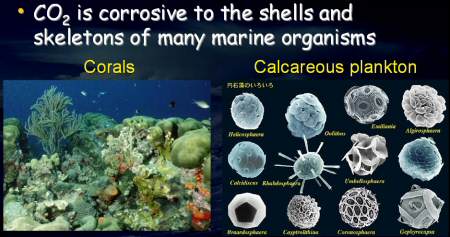
Absorption of large amounts of carbon dioxide alters the chemistry of the oceans by reducing the pH of seawater. With increasing carbon dioxide in seawater, shellfish and corals cannot absorb enough calcium carbonate to build strong skeletons and shells. The greater acidity slows the growth and even dissolves ocean plant and animal shells. The decline of these valuable species would drastically harm fisheries.
Any decline of these species would also have profound effects on entire ecosystems where shellfish and crustaceans provide food for many other species and coral provides habitat for fish. The effects of ocean acidification will potentially extend to coral reefs, marine plankton, other animals and plants.
For further details of this research project are here.
Natural England produces undersea landscape maps as educational tool
Natural England has produced a national undersea landscape map along with a series of regional undersea landscape maps for use as an educational tool.
These maps describe the underwater landscape and the distinctive places for wildlife, and provide illustrations of the creatures who live there.
The enlarged map for the East shows the movement of the offshore sand and shingle, a fact long denied by the dredgers and their apologists.
You can see these maps here.
Europe's first artificial surf reef is being built at Bournemouth
Europe's first artificial surf reef is currently being built in Boscombe, Bournemouth this year and is set to put Bournemouth firmly on the UK surf map. The surf reef will act as a ramp, pushing waves upwards, doubling their size and improving their quality for surfers. As a result, the number of good surfing days will be doubled. The reef will also enhance water sports on offer including kite-surfing, windsurfing, wake-boarding, kayaking, SCUBA-diving, sailing and skim-boarding. It is also expected to be provide habitat marine life such as crabs, lobsters, squid and various species of fish.
For further details, visit BBC Radio4 "Open Country" broadcast on 18th October 2008 or visit the A1 Surf website at www.a1surf.com
You can have your sea defences - if you pay for 'em!
Referring the EA's abandonment of flood defences protecting thousands of acres of farmland, 20 homes and the A12 Ipswich to Lowestoft Road (all around the Blyth Estuary near Southwold) on 18th October EA regional director Paul Woodcock kindly announced that villagers living nearby could be shown how to help themselves when there is no money available to repair the flood banks.
See the whole article 'DIY sea defences backed by government' written on the 19th October '08 Eastern Daily Press by Haley Mace by going to:
Government completes consultation on "High Level Objectives" for marine management
In preparation for the introduction and subsequent implementation of the Marine Bill, the UK Government has just completed a public consultation on the "high level marine objectives" which should inform and direct the Government's thinking on the key management principles for UK seas. As might be imagined, central to these is sustainable development. In addition, the Government want to see an "ecosystems approach" to marine management.
The Wildlife and Countryside Link, (www.wcl.org.uk) which represents a wide range of marine NGOs, state in their response to this public consultation that they would like the term "sustainable marine development" which the Government uses in its consultation document to be re-phrased as "sustainable development of the marine environment/area". WCL also want the Government to use a broader definition of the "ecosystems approach" to marine management based on the definition devised by the Convention on Biological Diversity. Namely, a definition which incorporates the following three elements: "sustainable use", "equitable sharing of benefits" and "conservation". At the present time the Government's definition, WCL believes, does not place adequate emphasis on the "conservation" element. Also, WCL believe that the "ecosystems approach" must include the concept of "recovery" in order to ensure that adequate management attention is given to marine ecosystems which have been damaged by past activities.
New Minister takes charge of the UK Marine Bill
Following the latest Government reshuffle, Huw Irranca-Davies MP has replaced Jonathan Shaw MP as the Minister of State at Defra in charge of the Marine Bill.
Huw Irranca-Davies has given a speech on 8th October 2008 to the Local Government Association and its Information Unit which outlines the Government's current thinking and approach to the Marine Bill.
The Government is planning to introduce the Bill in the new Session of Parliament, which begins in December, and believes that the Marine Management Organisation, which will deliver many of the Government's policies with regard to marine planning and licensing, will be operational by 2010. The new Minister's speech explains the Government's current thinking but, unfortunately, says nothing about the ecosystem-based approach to marine management or the network of marine reserves which MARINET believes are the fundamental tools which the government must develop seriously and urgently if we are to get fisheries and marine biodiversity back onto a sound basis throughout UK seas.
New Coastal Erosion Sensing Technology
This story, sent to us by Jerry Berne of Sustainable Coastlines, comes from the latest (Oct. 13-26) 'The Engineer 'magazine. This UK developed methodology will detect and transmit erosion data both at the shoreline and deep on the seabed. It is to be hoped that this will be deployed in order to provide conclusive evidence of the movement and destination of our beach, dunes and sand cliffs where intensive and cumulative offshore dredging has been permitted..
Coast guard
UK collaboration develops technology that could save lives by gathering and wirelessly transmitting coastal erosion data from beneath the sea. Siobhan Wagner reports
A NEW sensor communication system that directly transmits data from underwater sensors to shoreline bases claims to monitor more closely the effects climate change has on coastal erosion. The technology is the result of an 18-month UK industry and academic collaboration. Sensors on the seabed around the UK's coastline would gather data such as temperature, pH levels and sediment movement. This information would be fed to an underwater radio modem that transmits the data wirelessly to an onshore radio modem connected to a PC.
The backbone of the technology comes from project partner Wireless Fibre Systems (WFS) a Scots developer of underwater electronic communications, sensing and navigation technology. The company's underwater radio modem uses a magnetic loop antenna capable of generating an electromagnetic field of under 9kHz. The data is encoded in the magnetic component detected by a second sensitive receiver loop. The signal is enhanced with digital signal processing.
Ian Crowther, general manager of environmental and industrial division at WFS, said one of his company's underwater broadband modems has been proven to transmit signals at speeds of 1Mb/sec. 'There is no content that is restricted,' he said. 'It can transmit voice, data or video.' Crowther added that these signals penetrate both water and air and operate in both shallow and deep water. For monitoring coastal erosion, the sensors need to be up to 200m from shore.
The project has received about £450,000 from the Technology Strategy Board and will be managed by the School of Applied Computing at Swansea Metropolitan University. Valeport, a UK hydrometric and oceanographic instrumentation manufacturer, is the other partner in the initiative. The collaboration hopes to develop a technology that will, for the first time, gather and wirelessly transmit data related to coastal erosion from beneath the sea in real-time.
'It hasn't been done before because there has been no technology available that can transmit data from beneath the sea back to shore - not wirelessly anyway,' said Crowther. Previous systems could only relay data back using either a buoy on the ocean surface or a cable running from the underwater installation to the shore. Crowther added: 'No-one has been very successful at getting two-way communications, but by applying novel digital signal processing techniques and new antenna designs to existing science we have been able to increase the data rate and establish two-way communications with our system.'
The information gathered will support decision-making on coastline management around the world. Coastal erosion is caused by the impact of waves and small particles of rock and sediment wearing away the land. According to recent research at London's International Institute for Environment and Development, one person in 10 worldwide lives less than 10m above sea-level and near the coast.
Current scientific data suggests that climate change will continue to cause rising sea levels and speed up beach erosion. Crowther and his colleagues believe potentially disastrous situations could be avoided with better monitoring of what is happening below the sea. He said much of today's information about coastal erosion is gathered from aerial photographs. 'With our underwater system you will be able to understand things such as sediment movement from the sea bed which you can't get from aerial photography,' he said.
WFS has recently won contracts to use its technology in the defence and offshore oil and gas industries.
UK Government responds to Parliament's criticism of draft Marine Bill
The UK Government (Defra) has published its response to the changes to the draft Marine Bill recommended by the Joint Committee of the House of Commons and the House of Lords following public hearings by the Joint Committee in June and July. MARINET submitted written evidence to this Committee but was not granted an oral hearing, (see www.marinet.org.uk/marinebill.html#mswe). MARINET's comments on the recommendations of the Joint Committee and the response of the UK Government are as follows.
In its recommendations to the UK Government, the Joint Committee of Parliament has shown sympathy for the far-reaching change to the Bill proposed by MARINET. Namely, MARINET's proposal that "there should be a duty on the Secretary of State to create an ecologically coherent network of highly protected marine reserves covering at least 30% of UK seas out to 200 nautical miles by 2015". Many aspects of MARINET's proposal were incorporated into the Joint Committee's recommendations. However the UK Government has yielded little ground in its response to the Joint Committee and its recommendations.
Even the most apparent concession to the Joint Committee by the Government, (ref. para 3.4.1:) "We therefore propose to confer a statutory duty on the Secretary of State [MARINET editor: our emphasis] and Welsh Ministers to designate Marine Conservation Zones in order to contribute to an ecologically coherent network of sites which will include highly protected sites" is not entirely what it seems.
This concession, MARINET observes, is largely empty because the term "an ecologically coherent network" remains undefined in the draft legislation. Therefore, this vitally important management tool can be interpreted to mean anything by the Government. In addition, the size of this network remains undefined in the draft legislation, so the "statutory duty to create an ecologically coherent network of Marine Conservation Zones (MCZs)" can also mean whatever the Government likes - a duty to create ten reserves, one hundred reserves or whatever figure is considered expedient. It is difficult not to conclude, therefore, that the Government's concession has a hollow ring to it.
Furthermore, the agreement to create "highly protected" marine reserves is equally unquantified. MARINET believes that highly protected reserves (where all human activity is prohibited) is the key management tool that can deliver the recovery of our fish stocks and restore marine biodiversity. Substantial areas of the sea (at least 30%) must be set aside for this purpose, and be used as a commercial tool as much as an environmental tool. The UK Government has failed to understand or embrace this approach to marine management. In other words, the Government's policy on "highly protected" marine reserves looks rather unconvincing.
Evidence for a loss of nerve by the Government is further evidenced by its refusal to set a target for the size of the ecologically coherent network (Marine Protected Area - MPA), (ref. para 3.4.2:) "We consider it too early to predict the size or shape of the MPA network which will be needed, and therefore we do not propose to include a prescribed figure on the face of the draft Bill. We will only know what proportion of the seas will require designation as MCZs, and with what levels of protection, after further detailed work is undertaken, with the full involvement of stakeholders."
Is the Government unaware, MARINET observes, of the recommendation (www.rcep.org.uk/fisheries/Chapter8.pdf) by the Government's own the Royal Commission on Environmental Pollution in 2004 that 30% of the sea should be set aside as highly protected no-take reserves? And is the Government unaware that 300 senior European marine scientists have called for (www.marinet.org.uk/latestnews.html#jcop) the same level of protection?
The UK Government claims that it is not prevaricating, and that it has responded to the Joint Committee of Parliament by stating that it is serious about designating a substantial area of the sea for active management by means of marine reserves, (ref. para 3.4.8:) "We therefore propose to place a duty on Ministers to submit a report to Parliament . . . . on progress made in developing the network of MPAs and on progress towards achieving the conservation objectives of MCZs which have been designated as part of the network, in 2012 and at least every six years thereafter."
However MARINET asks whether this claimed commitment to creating a substantial ecologically coherent network of reserves is credible? Is a Report every six years the same as actually doing the job and creating the network? Is Parliament simply going to told every six years that progress is slow, and everything is just too difficult? MARINET is not convinced by this approach and fears that, in these intervening six year periods, our commercial fish stocks will become extinct (as in Newfoundland, Canada) and that marine biodiversity will continue in steep decline. The UK Government already has all the scientific evidence it needs. What it lacks, MARINET believes, is the will to act.
Yet despite the stand-offish position displayed by the UK Government to seriously taking up the challenge to use highly protected marine reserves between now and 2015 as the key management tool in the restoration of UK fisheries and marine biodiversity, MARINET believes that there is a glimmer of hope in the Government's response to the Joint Committee's report.
The Government states (ref. para 3.5.14:) "The legislative framework for the CFP (EU Common Fisheries Policy) is due to be reviewed in 2012 and by the end of 2011 the Commission is required to present to the Council and Parliament (EU Council of Ministers and EU Parliament) a report on access arrangements, after which the Council will decide what provisions will thereafter apply. In advance of this review, where we wish to protect an MCZ (Marine Conservation Zone) in an area where foreign vessels have access, we will look to do so through the CFP to ensure equal application of measures to all vessels."
MARINET understands this to mean, firstly, that the Common Fisheries Policy will be reviewed and revised in 2012, and secondly, that the UK Government will argue for the exclusion of foreign fishing activity from marine reserves (MCZs). If this happens, then MARINET's case that highly protected marine reserves can be used as a key management tool to regenerate fish stocks and marine biodiversity could, if the UK Government is bold enough, be argued for by the UK before the EU Commission and all the other EU member countries. In other words, real conservation policies and real management for our seas could be on the agenda.
MARINET is further emboldened in this belief by the EU's established regulatory policy on fisheries conservation, as stated in Council Regulation (EC) No. 2371/2002 on the conservation and sustainable exploitation of fisheries resources under the Common Fisheries Policy see www.marinet.org.uk/marinebill.html#ugrt
MARINET observes that Article 4.2.g which deals with the types of conservation measures which member states can take under Council Regulation 2371/2002 records (ref. para ii): "Adopting technical measures, including - zones and/or periods in which fishing activities are prohibited or restricted including for the protection of spawning and nursery areas" and (ref. para iv): "specific measures to reduce the impact of fishing activities on marine eco-systems and non target species."
Accordingly, MARINET believes that the UK Government has a mixture of UK sovereign powers and EU powers which enable it to establish an ecologically coherent network of highly protected marine reserves for the purpose of managing the eco-system of our seas as a whole, including fisheries, and thus we can implement such a network covering at least 30% of UK seas out to 200 nautical miles by 2015. All that is required is a UK Government which shares this belief, and is prepared to so act in the best interest of the UK's marine environment.
Thus, the key question now is - do we have such a Government in the UK? When the Marine Bill comes before Parliament in December of this year (2008) we shall learn the answer to this question. And, we shall also learn the answer to the question as to whether Her Majesty's Opposition Parties in Parliament share a belief similar to MARINET's. Some interesting questions and answers lie ahead.
Saltmarshes in the Solent under long-term threat
At a recent meeting of the Solent Protection Society where the importance and value of saltmarshes for biodiversity and coastal defence in the Solent estuary, Hampshire, was emphasised by speakers from Natural England and the Environment Agency, it was also predicted by the Channel Coastal Observatory (www.channelcoast.org/southeast) that saltmarshes are likely to disappear from parts of the Solent within 30 to 50 years.
A report of this meeting of the Solent Protection Society can be seen on the MARINET website here
Arctic summer sea ice recorded at second-lowest extent during 2008
The National Snow and Ice Data Centre (NSIDC), University of Colorado, which monitors sea ice extent in the Arctic says that despite cooler temperatures and ice-favouring condition this summer, the long-term decline continues, see Press Release

The magenta line shows the median ice extent for September from 1979 to 2000
The NSIDC says that the 2008 season strongly reinforces the thirty-year downward trend in Arctic ice extent. The 2008 September low was 34% below the long-term average from 1979 to 2000 and only 9% greater than the 2007 record. NSIDC Senior Scientist Mark Serreze said, "When you look at the sharp decline that we've seen over the past thirty years, a 'recovery' from lowest to second lowest is no recovery at all. Both within and beyond the Arctic, the implications of the decline are enormous", and NSIDC Research Scientist Julienne Stroeve said, "I find it incredible that we came so close to beating the 2007 record - without the especially warm and clear conditions we saw last summer. I hate to think what 2008 might have looked like if weather patterns had set up in a more extreme way."
For a full listing of press resources concerning Arctic sea ice, including previous press releases and quick facts about why and how scientists study sea ice, visit http://nsidc.org/arcticseaicenews
The growing hazard at Sizewell
Readers will be aware from our past items of the erosive threat to the Sizewell 'A' and 'B' nuclear power station, especially now that a further proposal to dredge even more aggregate much closer to the shoreline is under consideration.
The following clip is from 'New Scientist' written over fifteen years ago, accompanying a highly myopic penning on 'Managed Retreat' by Fred Pearce, who should have known better. But it shows you how insanity has grown even further since then.
MARINET wonders if the new French owners of Sizewell are aware of the hazard. The remote shareholders, i.e. the French government, are unlikely to know this. The awareness could change their mind !.
From issue 1854 of New Scientist magazine, 02 January 1993, page 23. 'Nuclear plants at the water's edge'
A Government guidance note on coastal planning, issued in September, says that new building developments away from existing urban areas should not in general be allowed on coasts threatened by erosion. But, all along Britain's coasts there are thousands of structures that would not have been built if this guidance had been in force at the time, and some are still being proposed.
Among them are several nuclear power stations. At Sizewell in Suffolk, the Sizewell B station is nearing completion next door to Sizewell A. The government-owned Nuclear Electric says it wants to build another station, Sizewell C, on the same site. 'You wonder,' says Andrew St Joseph, 'about the wisdom of building two or three nuclear stations at Sizewell, on a shifting spit that is likely to erode over the coming decades.'
Nuclear Electric claims that Sizewell is safe from inundation by the sea. But Paul Hatchwell, an environment consultant, wrote recently in a report for the World Wide Fund for Nature that both the Sizewell site and the Bradwell nuclear power plant in Essex, built on marshes by the Blackwater estuary, are 'poorly defended'.
The two Dungeness nuclear power stations on Romney Marsh in Kent are on a gravel spit. He says 18 of Britain's nuclear power plants are on land liable to flooding and dependent on local flood defences.
Aggregate dredging off East Anglia to be assessed
The aggregate dredging licences offshore from East Anglia are to be assessed for their environmental impact by means of a Regional Environmental Assessment (REA). The study is being designed at the moment by the consultants, Emu Ltd, who are working for the Anglian Offshore Dredging Association (AODA) which consists of Hanson Aggregates Marine Ltd, United Marine Dredging, Volker Dredging Ltd and Sea Aggregates Ltd. The REA should be completed by 2009.
Emu Ltd is currently drawing up a Scoping Study for this REA, see their website at www.anglian-marea.org, and is asking for interested parties and people to submit their thoughts on what this REA should consider and assess. If you wish to submit views, visit their website.
MARINET has informed Emu Ltd and AODA that it is essential that the REA incorporates a tracer study to establish where sand taken by tides from the beaches ends up. Also, the REA must include an up to date wave regime model (waves arriving on the coast cause erosion) which tests whether aggregate dredging is contributing to erosion, and part of this study into the wave regime must also assess the changes that have occurred to offshore sandbanks since aggregate extraction commenced. If offshore sandbanks have altered (i.e. their height has declined) then the wave regime will have been altered. It is known that one of the principal offshore sandbanks, Scroby Sands, has changed significantly during the period in question and the nature of this change and its causes needs to be carefully evaluated. Also, the REA must examine the changes in marine biodiversity during the period, particularly with regard to fisheries and marine biodiversity on the seabed.
Further details of MARINET's submissions to AODA and its consultant, Emu Ltd, can be seen at www.marinet.org.uk/mad/objection.html#rea
New Coastal Defence Structure Idea
Jerry Berne of Sustainable Coastlines (www.sustainableshorelines.org) spotted this item entitled 'Cloaking the Coast' in the 3rd October issue of The Engineer Online. It has been sent on to our EA Coastal Engineer for consideration.
Mathematicians at Liverpool University, working with physicists at the Centre National de la Recherche Scientifique (CNRS) and Aix-Marseille University, have designed and tested a new structure that could reduce the risk of large water waves overtopping coastal defences. The new structure is cylindrical and consists of rigid pillars that guide water along concentric corridors. The pillars interact with the water, guiding it in different directions along the corridors and increasing its speed as it nears the centre of the structure - similar to a whirlpool.
'Coastal defences have to withstand great forces and there is always a risk of water overtopping or penetrating these structures. Water crashes against these defences, breaking the wave and causing a lot of damage to property hidden behind them,' said Sebastien Guenneau, from Liverpool University's Department of Mathematical Science.
What is unique about the new structure is its interaction with the water, guiding it to a particular destination, rather than breaking it up and sending it everywhere. It is as though the defences are invisible to the wave, and as such it does not recognise the structure as an obstacle.
'We now need to investigate how to replicate this effect in a real-life situation to protect land from natural disasters such as tsunamis, and defend other structures such as oil rigs in the ocean,' added Guenneau.
Study looks at effects of dredging
That's the title of an article by Hayley Mace in the Eastern Daily Press of 7th October 2008. It tells how the Anglian Offshore Dredging Association (AODA) are to investigate the effects of dredging off the Norfolk and Suffolk coasts on fishing and coastal erosion by a major year-long scientific study supported by the MFA. The environmental study will be examined before any decision about the new site is made.
Robert Langman, AODA's coordinator, said that the environment impact assessment for the East Anglian coastline has just started. He said: "Although each individual environmental impact assessment has considered all the regional impacts in the past, this is the first time the potential impacts of offshore dredging and the cumulative impacts it may have with other sea users have been studied at a regional level in this area. We hope our pro-active approach will help manage this workload."
The full story is available here.
New fears for Suffolk coast
The 7th October 2008 East Anglian Daily Times hosts a story by Richard Smith telling how large numbers of homes and businesses on the Suffolk coast around Aldeburgh and Orford could be lost if the Environment Agency decides to abandon sea and river defences. The Alde and Orr Association estimates the economic value of the Alde and Ore estuary to be at least £25million annually. This excludes the value of crops and the gross output of £7m of 10 key employers. They point out that at peak times the Lower Alde area can account for up to 50% of the nation's potato production and that the loss of jobs in the agricultural industry if farmland surrounding the Alde and Ore were lost and salinated would have a major effect on local employment.
The full story can be read here.
EU takes important green step forward to reform the Common Fisheries Policy
The EU Council of Ministers has announced, following a recent meeting in Brussels on 29/30th September, that the "eco-system approach" is an important principle which should inform the reform of the Common Fisheries Policy (CFP) which is scheduled for 2012, and the EU Ministers have declared that they recognise that healthy ecosystems are essential for the sustainable exploitation of marine resources.
In response to this statement, the EU Commission has declared that "An economically, socially and environmentally healthy fishing industry depends on healthy fish stocks and on the fishing fleets being in balance with their fishing opportunities. Ecological sustainability is therefore fundamental."
The Commission intends to table a Green Paper in early 2009 which will provide the basis for a public debate. A summary of the consultation will be published in early 2010, and the Commission will aim to table reform proposals later in the same year, with a view to their coming into force in 2012.
MARINET is arguing strongly for the UK Government and its EU partners to develop a policy where no-take marine reserves are used as a key management tool in the regeneration of commercial fish stocks, many of which are currently being exploited beyond safe biological limits and thus could face commercial extinction.
This recent development in the thinking of the EU Ministers and Commission is welcome, in MARINET's opinion, and suggests that the EU is beginning to get a grip on reality. In fact, Council Regulation (EC) 2371/2002 on the conservation and sustainable exploitation of fisheries resources under the Common Fisheries Policy (view here) already gives the CFP powers to create "zones and/or periods in which fishing activities are prohibited or restricted including for the protection of spawning and nursery areas" and "specific measures to reduce the impact of fishing activities on marine eco-systems and non target species" (ref Article 4, section 2, para ii and iv). Therefore MARINET will be following closely how the forthcoming review of the CFP develops.
At the moment, the UK Government in its forthcoming Marine Bill (due to be published in December) is pleading that it can do nothing to control unsustainable fishing practices beyond the 12 nautical miles territorial limit because of the CFP. In MARINET's opinion, the UK Government is running away from the issue and does not appreciate the powers of intervention which the UK and other EU members actually possess. Greater political determination is required, see MARINET's submission to the UK Government.
PowerBuoy Wave Energy
Ocean Power Technologies (OPT) announced late September that it has deployed the first of ten PowerBuoys about 4 km off the coast of Spain at Santoña in 50 metres of water. This project is in partnership with Iberdrola S.A, one of the world's largest renewable energy companies. www.oceanpowertechnologies.com/spain.htm

The system has been trialled in Hawaii (for US Navy) and in Atlantic City, New Jersey (public utility) since 2005.
The PB40 PowerBuoy is the first unit for the world's first commercial utility-scale wave power generation, aimed at supplying about 1.4 MW to Spain's electricity grid.
Mark R. Draper, Chief Operating Officer of OPT, said: "This deployment is of great significance to OPT and the wave power industry, demonstrating the commercial potential of our leading technology after a decade of in-ocean experience. We would like to thank our partners, especially Iberdrola and the Spanish authorities, for their outstanding support to this project. We now look forward to the first supplies of electricity to the grid and the expansion of the wave power station."
PowerBuoys have a design life of 30 years with standard maintenance recommended every three to four years. The project includes a subsea power transmission cable and underwater substation and grid connection. As well as installing the hardware, OPT is contracted for operations and maintenance of the wave power station for up to 10 years.
The PB40 steelwork was fabricated by a local supplier in Santander, Spain, and the power take-off and control system was built at OPT's facility in New Jersey, USA. The final integration and testing of the complete PowerBuoy was also conducted in Spain. The PowerBuoy is 7 metres in diameter at the sea surface, 20 metres in length and weighs approximately 60 tonnes.
Abandoning Suffolk beaches and defences - or a reprieve?
The following item by Alasdair McGregor in the EDP of 1st October '08 outlines the severe threat now facing the coastline of North Suffolk as offshore dredging continues to wreak its demand from the shoreline and offshore banks. Already erosion is very serious and noticeably escalating, yet the worst of the North Sea Surges and strong eroding northerly winds have yet to arrive. February could see severe and irreversible damage resulting, unless some of the considerable income derived from dredging royalties and taxes is diverted to meaningful protection.
The cost of the loss of tourist income, unemployment produced and loss of infrastructure that will result in this already economically deprived and high unemployment area is vastly more than the savings made by refusing funds for defence or even the income dervied from the sand and gravel supply which will result from the coastal loss.
£2m to 'shore up' Lowestoft defences
The growing threat to Lowestoft's coastal defences was laid bare last night after it emerged £2m must be found to carry out vital repairs along the main beach, while a nearby sea wall is in danger of collapse within weeks. Sea defence managers are set to apply to the Environment Agency for the funding to carry out work on the town's showpiece south beach, but have admitted defences at nearby Corton are falling apart and will have to be abandoned. Meanwhile, a stretch of beach at North Denes has been closed where erosion has exposed the remnants of previous defences, which now pose a major danger to beach users.
With an annual sea defence budget of just £350,000, Waveney District Council is having to battle for national funding with coastal communities across the country. The plan to seek £2m for work on the south beach, opposite Royal Green, was hatched because of the huge number of tourists it attracts and the number of businesses based there. The council wants to carry out repairs to the foundations of the flint sea wall, built more than 100 years ago, and construct new groynes to help improve beach levels, which have been dramatically reduced in recent years.
However, just a few miles along the coast at Corton, council officers are preparing to put up barriers to stop people walking on the southern section of sea wall that runs northwards towards Hopton because erosion could see it collapse as soon as this winter. The neighbouring timber breastwork, which protects the cliffs from Corton village to the Broadland Sands Holiday Park, is also falling apart and the decision has been taken not to invest any more in its maintenance.
Paul Patterson, who is in charge of sea defences in Waveney, said: "The northern part of Lowestoft south beach is suffering scour that has reduced the amenity value of the area and also placed at risk ageing defences that protect the promenade and tourist facilities from erosion." Work to improve the most vulnerable section of the wall took place last winter and a study is being carried out in preparation for the major project, which is scheduled to take place during the winter of 2009/10.
While the Kelling to Lowestoft Ness Shoreline Management Plan (SMP) says the defences along the south beach and North Denes should be maintained, it says there is no economic justification to carry on work at Corton. Mr Patterson added: "The most significant erosion pressure is being felt from Lowestoft Ness northwards to the county boundary north of Corton village." The new barriers on the sea wall will have gates to allow public access to the wall until officers decide it is too dangerous.
Last year, the EDP reported how villagers in Corton felt abandoned by the SMP, which says new defences completed in 2005 at a cost of £3.5m will not be replaced when they reach the end of their lifespan in 20 to 30 years. Forecasts showed that 40 buildings could be lost on the seaward side of Corton Road and The Street by 2055 and, by 2105, a further 60 properties could be claimed by the sea. While the state of some defences in Corton is critical, Waveney District Council is promoting a joint study with Great Yarmouth Borough Council to explore opportunities to manage crumbling defences.
Ken Sale, the council's portfolio holder for the environment, said: "Tourism is the lifeblood of Waveney and Lowestoft beach is one of the best. As politicians all we can do is carry on lobbying the government to get more funding, but you can just put a concrete wall around the whole of the country."
Protecting Coastal Wildlife from the Sea-Defence upheaval
Ed Foss writes in the 29th September '08 Eastern Daily Press this item on some measures being taken to attempt to safeguard the wildlife when disturbance from heavy engineering takes place on the wilder parts of the Norfolk Coast.
Moves to save seals from coast work
Efforts to protect seals, their pups, little terns and ringed plovers will be among the ecological measures taken during sea defence work on the north Norfolk coast, which is due to start next month.
As reported in the EDP last week, Environment Agency contractors will bring in 30,000 tonnes of sea defence rock by barge to the coast at Eccles and Horsey and dredge 280,000 cubic metres of sand to recharge the beaches at Sea Palling and Waxham. The news of the major, multi-million-pound operation raised concerns among those who know the stretch of coast well - particularly in connection with a well-known colony of seals often seen hauled up on the beach around Horsey.
Chris Barton, from Knapton, contacted the EDP and said he had specific concerns about the breeding colony, which was entering the time of year when pups were born. But the seal issue is just one of several matters involving both wildlife and safety to people which the Environment Agency has said will be taken into account by a series of mitigation measures.
These include:
- In order to protect pups and seals, construction work on the groynes between November and January will be supervised by an ecologist to ensure there will be no, or minimal, disturbance to the animals.
- Carrying out the work outside the bird breeding season to prevent adverse impacts on little terns and ringed plovers.
- Signs will be put up warning people of the hazards associated with both the construction and the groynes themselves on completion.
- A watching brief will be undertaken if the groyne construction disturbs the clay layer, because there is concern about disturbing unknown archaeological remains.
An exclusion area for part of the project which will see recycling of old rock into repaired groynes will be set up around the ruins of St Mary's Church, which used to stand in the village of Eccles but was finally claimed by the sea when it toppled in 1895.
The beach recharge project was launched in the mid-1990s as part of a wider scheme which saw nine granite offshore reefs built at Sea Palling and Waxham to protect the Broads - resulting in altered patterns of longshore drift and the starvation of sand supplies to beaches to the south of the reefs. The recharging was controversially shelved in 2005 after Defra withdrew Environment Agency funding. That funding has now been made available again.
The rock will be used to build ten groynes between Horsey Ness and Winterton Ness Gap to replace failed timber or rock groynes. Surplus rock buried under the beach will also be excavated for reuse, while a 275-metre stretch of rock revetment at Eccles will be reconstructed.
Ongoing debate on Norfolk's Coastal Erosion
With equinoxial gales and the North Sea surge season close upon us, the coastal defence situation and the unacceptable demands of 'Managed Retreat' continue. This item is from the 'Eastern Daily Press' of 30th September '08
Coastal erosion studies awaited
Coastal engineers are continuing to make do and mend along north Norfolk's eroding shoreline while government officials wrestle with the larger national picture including the possibility of compensation.
A local council official, who is a leading figure in a nationwide think tank on erosion impact, says some major studies around Britain's coast should help identify places at risk and its value. But Peter Frew, head of coastal strategy at North Norfolk District Council, said any plans for compensation still had to leap the hurdle of getting treasury funding.
It would need to be "sound, properly controlled and not a blank cheque," added Mr Frew, but he was "satisfied we have a reasonable chance of sorting something out." His comments come after the latest "adaptation toolkit" workshop at the government's environment department, which - despite ministerial hints that people losing their sea defences under policy changes should get compensation - has yet to explain how they would be helped. "We are still looking for clarity, and are struggling to work out what it means," said Mr Frew. He was heartened by moves to stop areas at threat from being hit by blight, and increased involvement of regional development and transport agencies because of the wider possible impacts of erosion, such as the loss of roads.
A Defra erosion risk survey, due out in the spring, should give a nationwide picture of potential losses, while another project was seeking to evaluate the properties affected. In the meantime North Norfolk was continuing to defend where it could. This month a £250,000 sea walls and cliff path scheme due will start at Overstrand. Another £50,000-£80,000 will be spent at Sheringham or Walcott, and 400 tonnes of "spare" rock from the imminent Horsey defences upgrade will be used at the most appropriate place at the time it became available.
Fishermen's concern on new DEFRA catch limits
Fishermen fear for their livelihoods by Richard Parr, EDP, 2nd October '08
Fishermen along the North Norfolk coast believe their livelihoods could be under threat if proposed changes to fishing regulations come into force. North Norfolk MP Norman Lamb is calling for urgent talks with the government's fisheries minister Jonathan Shaw after he was approached by local inshore fishermen from Wells, Sheringham and Cromer. Mr Lamb said: "I am horrified at the prospect of the fishing fleet at Wells and along the North Norfolk coast being decimated by these proposed changes."
The changes, being proposed by the Department for the Environment, Food and Rural Affairs (Defra) are currently subject to a public consultation period which ends tomorrow. The concerns have been highlighted by Robin Harris who has fished out of Wells for the past six years. He claims the changes proposed will affect the under 10 metre class of fishing vessel which makes up the vast majority of the Wells fleet.
The new regulations, if introduced, would impose a 300 kg annual limit for a licence holder fishing for skate, rays, cod and sole. This limit would apply unless 300 kg of the specified species had been caught during the qualifying period of October 2006 to January 2008.
The issue for the Wells fishermen is that most of them will be unable to prove they have caught the necessary quota during this period because they have been primarily catching crab and lobster. Most of the North Norfolk inshore fishermen alternate their catch from year to year based on supply and the proposed changes to licensing regulations would inhibit fishermen from fishing certain species in the future.
Cromer fisherman John Davies said that the proposed changes threaten their livelihoods. "The only way an inshore fisherman will be able to survive is by being flexible and it is this flexibility that is at risk," said Mr Davies, who is also coxswain of Cromer lifeboat. An inshore fisherman needs to be flexible in what he can catch otherwise a certain amount of his livelihood will be taken away. A Defra spokesman said: "It is still at the proposal stage and people can still express their comments."
Felixstowe Update
The latest Felixstowe TV films of the sea defence strategy there can now be seen by going here and here.
An East Anglian Daily Times video showing the devastation of Felixstowe's North Beach can be seen by visiting 'What has happened to famous beach?'
Green Party to challenge new East Anglian offshore aggregate dredging licences
Cllr. Rupert Read, Norwich, the Green Party lead candidate for Eastern Region in 2009 Euro-elections, has announced that the Green Party will be challenging the new aggregate dredging licences being sought by AODA, the Anglian Offshore Dredging Association consisting of CEMEX UK Marine, Hanson Aggregates Marine, United Marine Dredging, Volker Dredging Ltd. and Sea Aggregates Ltd.
The new licences involve a large extension to Area 495B, which lies east of the existing dredging area located offshore between Gt. Yarmouth and Lowestoft. And a new area, Area 496, which is some ten times the area already being dredged at the existing site off Southwold. Area 496 is located to the west of the existing dredging ground, and is less than half the distance from the shoreline as the existing dredge site.
In a Press Release dated 24th September the Green Party state "In Holland, the world experts on coastline protection have a ban on dredging for aggregates closer than 25km to the shore. Yet here in England, we allow dredging to take place way closer than that. If this application is granted, it will be criminally irresponsible, at a time when man-made climate change is threatening in any case to raise sea levels and is already worsening winter storms."
"I intend" says Cllr. Rupert Read, "to ask a set of awkward questions of the dredgers; if they cannot adequately reply, then they owe it to the people of East Anglia to withdraw their application and take a more sensible, precautionary approach, rather than wading in and ruining our fragile coastline forever."
World's first commercial wave power project goes live
Babcock and Brown Ltd (alternative asset managing company), EDP (Portuguese Government: Energias de Portugal) and Pelamis Wave Power Ltd (Edinburgh based wave energy manufacturer) have jointly announced that the world's first commercial wave power project has gone "live". The Aguadora project is situated off the Portuguese coast and will initially generate power using 3 Pelamis Wave Energy Converters.
In this first phase the total investment corresponds to about 9 million Euros. The second phase of the project will be to manufacture and install a further twenty five machines and bring the installed capacity up to 21MW. The generators are located approximately 3 miles off the coast.
Once complete the project is expected to meet the average annual electricity demand of more than 15,000 Portuguese households whilst displacing more than 60,000 tonnes per year of carbon dioxide emissions from conventional generating plant. Antonino Lo Bianco, European Head of Infrastructure at Babcock and Brown, said, "I am very pleased to be announcing the start of this milestone project. Wave power offers huge potential, not just for Portugal but for many countries around the world where the harnessing of an inexhaustible supply of wave energy will produce a clean, zero carbon energy domestically. We expect wave power to become a widespread renewable energy technology and look forward to the benefits that investing at this early stage will bring."
Pelamis Wave Energy Convertors are semi-submerged, articulated structures composed of cylindrical sections linked by hinged joints. The wave-induced motion of these joints is resisted by hydraulic rams, which pump high-pressure fluid through hydraulic motors via smoothing accumulators. The hydraulic motors drive electrical generators to produce electricity. Power from all the joints is fed down a single umbilical cable to a junction on the sea bed. Several devices can be connected together and linked to shore through a single seabed cable. Current production machines are 140m long and 3.5m in diameter with 3 power conversion modules per machine. Each machine is rated at 750kW.
The energy produced by Pelamis is dependent upon the conditions of the installation site. Depending on the wave resource, machines will on average produce 25-40% of the full rated output over the course of a year. Each machine can provide sufficient power to meet the annual electricity demand of approximately 500 homes.
Pelamis Wave Power www.pelamiswave.com headquarters are in Edinburgh, Scotland. It has been developing the Pelamis technology for the past 10 years. The prototype for the Portuguese machines was launched in February 2004 and first supplied electricity to the UK grid in August 2004. The company has worked closely with a wide range of Portuguese suppliers in the development of this project and with a view to the onward commercial roll-out of the technology in Portugal.
Further details of this announcement
National Audit Office Investigation
The Great Yarmouth Mercury of 11th September 2008 reported on the NAO's investigation of MARINET's request.
Offshore dredging investigation
Hopes were raised this week that a link between coastal erosion and offshore dredging could be investigated further by a government spending watchdog. In June, North Norfolk MP Norman Lamb and environmental pressure group Marinet called for the National Audit Office to carry out a full investigation of the effects of offshore dredging because of fears it increases coastal erosion.
Although ruling out a specific investigation into whether dredging should be allowed to continue, the watchdog has announced a review of the way the Environment Agency deals with coastal protection. In a letter to the MP, it highlighted three main issues: the way the agency develops its strategies for managing the coastline; how it decides which schemes are given the go-ahead; and whether the "cost-benefit analysis" (an assessment of the benefits of coastal protection in relation to how much they cost) was adequate.
Pat Gowen, East Anglia spokesman for Marinet, said that although the watchdog had not agreed to a full investigation of dredging, he believed the announcement was good news. He said a review of the Environment Agency's role would be likely to include a look at dredging and could lead to a reduction in the activity.
On Monday, Mr Lamb agreed the review was a positive result. He said: "That is clearly good news. Many of us feel the cost-benefit analysis does not take into account fully the value of our landscape here and the importance of the communities that are affected." But the MP added the decision not to look specifically at whether aggregate dredging, which raised £17.7m for the government in 2007-08, should continue was disappointing. He said: "A vast amount of money is being raised by the government by issuing dredging licences - the very least they could do is agree to commission new research to ensure we have a better understanding of it."
Scotland's first no fishing zone established in Lamlash Bay, Isle of Arran
Scotland's first no fishing zone has come into effect in Lamlash Bay, off the Isle of Arran. The new community marine reserve has been set-up in part of the bay in an attempt to strike a balance between fishing and marine conservation. It is hoped the fishing ban will help protect local fish and shellfish populations and maerl seaweed beds. It is anticipated that as a result nearby scallop beds will become more productive, benefiting local fishermen.
The Community of Arran Seabed Trust (COAST) has been campaigning for 13 years for this "no-take" marine reserve and commercial fishermen in the area have also added their support. Environment Secretary Richard Lochhead praised conservationists, fishermen, and other members of the local community for working together and finding "mutually beneficial ground".
"We believe that it is important to take responsibility for our seas and the resources they represent" said Kenneth McNab of the Clyde Fishermen's Association. "It demonstrates what can happen when people work together on common goals and we empower communities to find local solutions to local issues. We will be watching the project closely, particularly as it is the first of its kind, to see what lessons can be learned for the future."
COAST chairman Howard Wood said the marine reserve marked a new beginning for the area. "After many years we at last have our marine reserve," he said. "We are now looking forward to the benefits it will bring and to working with a range of people over the months and years ahead."
The COAST project has been assisted by Tom Appleby of the University of Bristol Law School, who has helped with the complex legal issues which were raised during the decision process. COAST has also been supported by Professor Callum Roberts of the University of York, one of the world's leading experts on marine conservation. Prof. Roberts is also a consultant to the Royal Commission on Environmental Pollution and author of the influential book "The Unnatural History of the Sea." The diving organisation Seasearch also gathered vital evidence for COAST and their evidence underpinned COAST's proposals for Lamlash Bay. Seasearch is a volunteer underwater survey project for recreational divers who record observations of marine habitats and the life they support. Seasearch is co-ordinated by the Marine Conservation Society.
The underwater scientific baseline survey of Lamlash Bay starts next month and, with constant monitoring, the results will hopefully inform the management of Scotland's seas in the future. The scheme is unique in Scotland as it combines all the forces of the local stakeholders including conservationists and fishermen. It is hoped that it may be used as a template for elsewhere.
Further details: www.arrancoast.co.uk
Coastline Protection by creating further erosion
Despite our advice on the impact and concern of the consequences, again the Environmental Agency is dredging sand offshore to place on devastated beaches caused by dredging sand offshore. MARINET liken this to the unwise monkey who ate his tail in order to get the protein supply needed to grow a longer tail.
Please refer to www.marinet.org.uk/coastaldefences/beachrecharge.html for the detail.
This waste of money has been taken up by the Audit Office in response to MARINET's concern, so sanity may yet prevail.
The following article by Ed Foss appeared in the Eastern Daily Press of 23rd September 2008.
Sea defences 'beefed up'
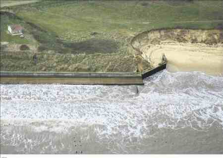 Eccles is one stretch of coastline where the sea cuts in behind the sea wall. It will be rebuilt with thousands of tonnes of rock. Photo: Mike Page.
Tens of thousands of tonnes of sea defence rock will be shipped to Norfolk's coast by barge in the run up to Christmas, while a sister operation pumps huge quantities of sand from the seabed to build up the beaches. The multi-million pound project will beef up and repair both the soft and hard defences around Waxham, Horsey, Winterton, Sea Palling and Eccles as contractors Team Van Oord carry out the work on behalf of the Environment Agency.
Although the news of strengthened defences has been welcomed, the detail of the wider management of such projects has been criticised by campaigners, as has the location from where the sand is being dredged. The project will see 280,000 cubic metres of sand used to recharge the beaches at Sea Palling and Waxham, while 30,000 tonnes of rock will be brought to Eccles and Horsey. The sand will be dredged from the seabed approximately 10 miles offshore between Yarmouth and Lowestoft and piped ashore.
The recharging project was launched in the mid 1990s as part of a wider scheme which saw nine granite offshore reefs built at Sea Palling and Waxham to protect the Broads - resulting in altered patterns of longshore drift and the starvation of sand supplies to beaches to the south of the reefs.
The recharging was controversially shelved in 2005 after Defra withdrew Environment Agency funding. That funding has now been made available again. Rock will be used to build ten groynes between Horsey Ness and Winterton Ness Gap to replace failed timber or rock groynes. Surplus rock buried under the beach will also be excavated for reuse, while a 275 metre stretch of rock revetment at Eccles will be reconstructed.
Last night, Malcolm Kerby of the Happisburgh based Coastal Concern Action Group, said the beach recharging was happening at a stage when it was "utterly urgent", but he said the decision to dredge so close to the coast was "madness". "The Dutch are the world's masters in this and they have a simple rule - don't dredge within 15 miles of the coast or you risk increasing erosion rates. Are we barking mad? It's too close."
Mr Kerby was also critical of the project not taking into account Happisburgh, especially the area called Low Light, which has long been considered a key 'back door' to the Broads. "Any defences for this bit of coast are a good thing, of course they are," he said. "But the one place that's most vulnerable, the Achilles heel if you like, is at Low Light, where no money has been spent for half a century, and you have yet another example of totally bonkers coastal mismanagement by the government. "If you wrote down what the government have been doing with our coast, you would be accused of making it up - no one would believe you."
An Environment Agency spokesman said last night: "It is more environmentally friendly to bring the rock in by sea rather than by road or train. "Delivery dates for the rock will begin in early October."
Greenpeace proposes an offshore Electricity Grid for the entire North Sea
A new Greenpeace report has revealed how a regionally integrated approach to the large-scale development of offshore wind in the North Sea could deliver reliable clean energy for millions of homes.
The North Sea Electricity Grid [R]evolution report (see the full report here as a pdf file) calls for the creation of an offshore network to enable the smooth flow of electricity generated from renewable energy sources into the power systems of seven different countries: the United Kingdom, France, Germany, Belgium, The Netherlands, Denmark and Norway. An integrated grid would bolster the development of renewable energy and allow significant emission savings.
"The grid would enable the efficient large-scale integration of renewable energy in the power system across the whole North Sea region. A dip in wind power generation in one area could be 'balanced' by higher production in another area, even hundreds of kilometres away, providing clean power for millions of European homes," said Frauke Thies, Greenpeace EU renewables policy campaigner.
The cost of developing the grid is expected to be between €15 and 20 billion. This investment would not only allow the broad integration of renewable energy, but also unlock unprecedented power trading opportunities and cost-efficiency. In a recent example, a new 600 kilometre-long power line between Norway and the Netherlands cost €600 million to build, but is already allowing €800,000 a day in cross-border trade.
"Building a North Sea grid is not just a pipe dream; it's common sense both environmentally and financially. Greenpeace has called on the European Commission to deliver a strong EU Action Plan for offshore wind and to push for a co-ordinated approach to make this scenario a reality." said Thies.
Greenpeace also calls for a co-ordinated European approach for the development of offshore network capacity which includes strategic grid planning at EU and national level, priority grid connection and access for renewable energy, and a European investment framework to encourage investments in grids.
Harmful anti-fouling paints on ship's hulls are now illegal
The International Maritime Organisation (IMO) has announced that an international convention banning the use of organotins and other harmful substances in anti-fouling paints applied on ships' hulls enters into force on 17 September 2008.
The International Convention on the Control of Harmful Anti-Fouling Systems on Ships (AFS Convention) was adopted on 5 October 2001 by IMO and the terms for its entry into force (ratification by 25 States representing 25 per cent of the world's merchant shipping tonnage) were reached last year. The Convention has, to date, been ratified by 34 States, with a combined 52.81 per cent of world merchant shipping tonnage.
Under the Convention, ships are not permitted to apply or re-apply organotin compounds which act as biocides in their anti-fouling systems. From now on ships either shall not carry such compounds on their hulls or external parts or surface or, in the case of ships that already carry such compounds on their hulls, will have to apply a coating that forms a barrier to prevent them leaching from the underlying non-compliant anti-fouling systems.
The Convention also establishes a mechanism to evaluate and assess other anti-fouling systems and prevent the potential future use of other harmful substances in these systems.
The Convention applies to ships flying the flag of a Party to the Convention, as well as ships not entitled to fly their flag but which operate under their authority, and to all ships that enter a port, shipyard or offshore terminal of a Party. It applies to all ships, including fixed or floating platforms, floating storage units (FSUs) and floating production storage and off-loading units (FPSOs).
Anti-fouling systems
Anti-fouling paints are used to coat the bottoms of ships to prevent sealife such as algae and molluscs attaching themselves to the hull - thereby slowing down the ship and increasing fuel consumption.
The AFS Convention defines "anti-fouling systems" as "a coating, paint, surface treatment, surface, or device that is used on a ship to control or prevent attachment of unwanted organisms".
In the early days of sailing ships, lime and later arsenic were used to coat ships' hulls, until the modern chemicals industry developed effective anti-fouling paints using metallic compounds. These compounds slowly "leach" into the sea water, killing barnacles and other marine life that have attached to the ship.
However studies have shown that these compounds persist in the water, killing sealife, harming the environment and possibly entering the food chain. One of the most popular anti-fouling paints, developed in the 1960s, contained the organotin compound tributyltin (TBT), which has been proven to cause deformations in oysters and sex changes in whelks.
Today, there are a variety of effective anti-fouling systems available which do not contain TBT, such as organotin-free anti-fouling paints and biocide-free non-stick coatings which have an extremely slippery surface - preventing fouling occurring and making it easier to clean when it does.
Food Standards Agency issues UK Shellfish Quality Classification for 2008
The UK Government (Food Standards Agency) issues an annual classification of the quality of shellfish production beds based upon the presence of E.coli per 100g of shellfish flesh. The classification runs from Class A to Class C based on the level of E.coli present. The presence of E.coli is generally attributed to sewage pollution, or its absence.
- Class A refers to areas with less than 230 E.coli per 100g of flesh.
- Class B refers to areas with between 230 and 4,600 E.coli per 100g of flesh in at least 90% of samples.
- Class C refers to areas where between 4,600 and 46,000 E.coli per 100g of flesh has been found.
All shellfish must meet Class A standards before it can be marketed and sold. Shellfish from Classes B and C will need further processing, for example heat treatment, to adhere to the EU legislation before they can be sold. It is the harvesters' responsibility to carry out the appropriate testing to sell their shellfish. If the level of E.coli present exceeds the upper limit of Class C, then harvesting from that shellfish bed is prohibited.
For a full list of classified UK shellfish harvesting areas in 2008 go to the link www.food.gov.uk/news/newsarchive/2008/sep/shellfish
Note: Information about the species of shellfish which are to be found on the Food Standards Agency website is as follows:
- C. gigas (Crassostrea gigas) is the Pacific Oyster, for details see www.marlin.ac.uk/species/Crassostreagigas.htm
- Mytilus spp. is the Blue Mussel (Common Mussel), for details see www.marlin.ac.uk/species/adult_distrib_mytilusedulis.htm
- C. edule (Cerastoderma edule) is the Common Cockle, for details see www.marlin.ac.uk/species/adult_distrib_cerastodermaedule.htm
- O. edulis (Ostrea edulis) is the Native Oyster, for details see www.marlin.ac.uk/biotopes/bio_basicinfo_imx.ost.htm
- M. mercenaria (Mercenaria mercenaria) is the Hard-shell Clam, for details see www.marlin.ac.uk/species/mercenariamercenaria.htm
Also, an illustrated guide and an explanation of the different species of mollusc and their life cycles can be found on the MARINET website, see www.marinet.org.uk/mreserves/marineanimals.html
Happisburgh erosion continues unabated
Here are two pictures taken by aerial photographer Mike Page of the North Norfolk village of Happisburgh. The upper picture was taken ten years ago, the lower as it is in September '08. And Happisburgh is just one example of many of the rate of erosion since large scale Offshore Aggregate Dredging commenced.
For further detail see panoramic views of Happisburgh (BBC website) and also In Pictures - A village under threat (BBC website)
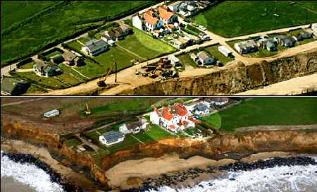
Tyndall Forum : 'How do we create a Sustainable Coastline?'
That was the title for the Tyndall Centre Forum held at the University of East Anglia on 10th September '08. It was attended by 63 invited guests including MARINET and members of our Coastal Group.
Read a report of the conference on the MARINET website here.
Sea Rise Undercalculated
John Welch points out in the Eastern Daily Press of 10th September that the new information in a study by the Met Office would make it appear that sea level rise could be two to three times that originally forecast, and even up to five times under surge conditions. This could prove catastrophic for much of East Anglia.
Fears for coast from new flood warning
Sea levels could rise more than twice as fast than currently predicted, putting large areas of East Anglia at serious risk from catastrophic flooding, new research suggests. A study by the Met Office has revealed that the government's official predictions for sea level rise are out of date because they do not include the effects of meltwater from the Greenland ice sheet. The situation is so serious that the Environment Agency is having to review its defence plans for London and other parts of the country.
 Virtual chaos: How the online game, Floodsim.com, visualises the centre of Norwich if sea levels rise
The extent of the problem was revealed for the first time yesterday by Dr Jason Lowe, a senior Met Office climate scientist, who has just completed the most detailed study yet into the likely rates of sea-level rise around Britain for the Environment Agency.
Dr Lowe said that, while the agency's current flood defences were based on predictions of a rise of just under one metre this century, average water levels around Britain could rise by as much as two or three metres. And the effects of storm surges, such as the one that created a major emergency alert on the Norfolk and Suffolk coast last November, could push water levels up further, to four or even five metres. If that happened, the present Thames Barrier, designed to cope only with rises of just over a metre, would be useless and some existing defences in East Anglia could also be over-topped.
Dr Lowe, speaking at the British Association for the Advancement of Science conference in Liverpool, said other major conurbations on estuaries or in coastal areas, as well as nuclear power stations, could now be considered vulnerable.
What worries scientists is new satellite evidence showing that the 1m square mile Greenland ice-cap is breaking up much more quickly than previously realised. Also, the Antarctic ice sheet is collapsing much faster than predicted. Met Office scientists have studied historical evidence showing what happened when the polar ice-caps last started melting 120,000 years ago. Their conclusion is that the rate of sea-level rise this century could be two or three times previous estimates.
For people in coastal areas of Britain, as well as those living close to tidal estuaries such as the Thames and Humber, the situation is made worse by increasing frequency of storms and extreme rainfall of the kind experienced for the past two summers.
Environment Agency head of flood and coastal risk management David Rook said sea defences for all of England and Wales were being reviewed but the most vulnerable areas were the East Anglian coast, the Thames and Humber estuaries and the entire east coast as far north as Flam-borough Head, in Yorkshire. He added: "We are currently undertaking a long-term investment strategy to look at the investment that needs to be made over the next 25 years, and we plan to publish a draft strategy in the spring of next year."
Michael Walker, chairman of the North-East Norfolk Coastal Parishes Group, said: "All the evidence has to be carefully considered, and no individual piece of research should be considered as actually changing the overall situation. I'm not alarmed at all by it on its own."
Progress on Wind Farms
This item in the East Anglian Daily Times of 10th September 2008 highlights the ongoing drive to provide more windfarms off our East Anglian coast.
Wind farm work moves closer
A massive crane barge is on its way to the Essex coast to help in the construction of an offshore wind farm. The 13,600 tonne Svanen is due to arrive off the shores of Clacton late next week when it will start work on foundations of the Gunfleet Sands Offshore Wind Farm - which is set to be fully operational by 2010. It is the next phase in Danish power firm Dong Energy's plans to erect a wind farm 7km out to sea that could power 120,000 homes, about 20% of Essex.
Peter Sills, Dong's head of communications for the project, said each monopile foundation was up to 50m tall and weighed 400 tonnes. "They will be driven up to 40m into the seabed by hydraulic hammer and it takes between two and four hours per monopile," he said. "The transition pieces are then mounted on top of the monopile by crane and painted yellow to assist with navigation. Each transition piece weighs 230 tonnes and is 23m tall. The total time to install a monopile and transition piece is under two days."
The large cranes and jack-up barges will be positioned using tugs, which utilise state-of-the-art positioning systems for pinpoint accuracy. These tugs will be working out of local ports in the Thames Estuary and a number of smaller vessels will be working out of Brightlingsea on the River Colne - carrying out surveys, continuing environmental monitoring studies, and ferrying personnel to and from the construction site.
Mr Sills added: "The wind turbines will be erected during the spring and summer of next year and will be commissioned in phases as the turbines become available for energy production."
Windfarms and Fishing
Although the placement of a windfarm base can, like wrecks, act so as to increase the fish population by habitat provision, fishing is excluded from the area. Further, the placement of wind farms can act as an impediment in important long established fishing grounds.
The following item in the Eastern Daily Press of 4th September '08" suggests that compromise may soon be forthcoming allowing consideration of the needs of fishermen's livelihood, off North Norfolk at least.
Fishermen to get bigger say on windfarms
Fishermen off north Norfolk are welcoming assurances they will get a louder voice over where the next batch of offshore windfarms will sited. The Crown Estate, which allocates windfarm licences, has told a national fishermen's lobby there would be better liaison to ensure sensitive fishing areas were avoided. Off Norfolk, where the seas are set to take up to another 1,000 turbines in the national push for green offshore energy, the news was given a guarded welcome.
Ivan Large, chairman of two fishermen's societies representing 50 boats in north Norfolk, said: "It will be good - if they do what they say."
Fishermen had been frustrated in the past at getting their concerns across to windfarm developers as they consulted over their environmental impact studies at the detailed stage - so would welcome the chance to get their point across during earlier strategic discussions over potential sites. "We are getting our message across - eventually. We don't want windfarms in important fishing grounds, or big exclusion zones we have to steam around. It would be another nail in our coffin," said Mr Large.
They were issues raised over windfarms currently in the pipeline, such as the scores planned at the Sheringham and Dudgeon Shoals. But the National Federation of Fishermen's Organisations (NFFO) has been told by the Crown Estate there would be better and earlier liaison over the third round sites, which include a large area off the North Norfolk coast as the Government turns up the wick to meet renewable energy targets. NFFO chief executive Barrie Deas said there was already a liaison group, but compared to a similar one on offshore oil and gas it had "failed to live up to expectations" he told Fishing News.
Mr Large said fishermen worked different areas of the seas at different times of the year, so the loss of any more grounds to windfarms was a potential blow.
The Seahorse Trust argues for greater protection of seahorses at Studland Bay
Sightings of Britain's two indigenous species of seahorse - the spiny and short-snouted seahorses - are on the increase. However an argument is brewing over how to protect the creatures which just a decade ago were extremely rare. Studland Bay, near Bournemouth, is home to Britain's largest known colony, according to the Seahorse Trust. Yet while seahorses became a protected species in the UK in April 2008, the Trust says that leisure boats anchoring off shore are destroying the eel grass in which they live and breed in.
 A spiny seahorse (hippocampus guttulatus) in Studland Bay, Dorset. Photograph: Steve Trewhella
Steve Trewhella, a marine photographer, has been monitoring the population for the Trust. "We found a pregnant male at Studland four years ago and it was the only one ever seen in the UK. Since then" he says "their numbers have been snowballing. We're into the 40s now, and still finding more. At least half have been pregnant males. They're not that common in the world and definitely unique here. You've got moorings scouring the grass, which is as diverse as any reef, and in the Bank Holidays there are more of them (moorings). Some people have said 'well they must be doing OK with the boats there but we need a closed area to see if it regenerates. Is it in decline? We have no idea. There's never been an opportunity to study wild seahorses in the UK. We've watched them courting - things we've never seen before. Each male can give birth to up to 300 young and be pregnant again within 24 hours."
Ian Alexander, team leader in the region for Natural England, says "We know that eel grass is a really important habitat for a range of species and there's no doubt boats cause a disturbance," Ian Alexander recommends a voluntary approach: "Anchoring is a public right. Boats have been persuaded in other parts of the country to keep clear. Voluntary is the right way to go. We all have a vested interest to ensure that the eel grass is protected."
Neil Garrick-Maidment, director and founder of the Seahorse Trust, says the wording of the Wildlife and Countryside Act which protects the species gives room for complacency. "It's a site of international importance. The Act says both the seahorse and its habitat are protected, but if you aren't aware that the moorings off the beach are illegal then you can say you didn't know. We're not trying to be killjoys, we're just saying be careful where you put your anchors- don't put them in the eel grass."
The British seahorse survey, which was set up in 1994 and part-funded by Natural England, has improved knowledge of seahorses using sightings by the public (around 700 in 14 years) and all sides agree that much is still unknown about the creatures. While Natural England represents the government's position, the Crown Estate owns the seabed and the National Trust owns the beach. Resolving the issue of the seahorses' habitat will therefore require careful co-operation.
Suffolk Coast - another victim of 'Managed Retreat'
Despite massive opposition and evidence as to the folly, the Government's Environment Agency is resolute in its plan to allow the sea to take some of the most beautiful part of coastal Suffolk. Here Jonathan Barnes, in the East Anglian Daily Times of 5th September '08 describes the intense anger engendered by those desperate to save the area.
Fury as Suffolk coast 'abandoned' to sea
Campaigners reacted with fury last night after it emerged the Environment Agency was pressing ahead with plans to abandon huge swathes of the Suffolk coast to the sea. The agency has confirmed it still intends to enforce its policy of "managed retreat" on the Blyth Estuary - despite massive public opposition to the plans. The council has responded by launching a £1.6million bid to heighten a stretch of the A12 at Blythburgh to stop the key link road between Ipswich and Lowestoft flooding.
The Environment Agency (EA) announced last year it could not afford to maintain river defences on the Blyth beyond five years - and that Southwold Harbour could only be protected for the next 20 years. It said the estimated £35m cost of maintaining the defences could not be justified - but local people reacted with anger after it emerged that thousands of acres of farmland would be lost to the sea, while as many as 23 homes could be at risk of flooding. The policy is also likely to be repeated in other estuaries in Suffolk and Essex, starting with the Alde and Ore and the Deben.
Campaigners held huge protests against the plans - forming a human SOS sign on Walberswick beach in February and a human chain on Southwold promenade in August, timed to coincide with Prime Minister Gordon Brown's holiday in the area. They said the plans would effectively cut off Southwold and cause the A12 to flood regularly where it crosses the estuary at Blythburgh.
But it has now emerged that, following public consultation, the agency has decided to go-ahead with its plans, which it will discuss at a meeting in Ipswich on September 26. It is understood the EA has accepted it should continue to defend the northern river wall, which protects Reydon Marshes, and the A1095 road between the A12 and Southwold. But it is committed to managed retreat along the Blyth, saying that maintaining the defences was "not a high enough priority".
Guy McGregor, Suffolk County Council's portfolio holder for roads and transport and chairman of the Blyth Strategy Group, said: "I am frustrated that a sensible approach has not prevailed. The agency's cost-benefit analysis is fundamentally flawed. They have not taken into account the value of Southwold and its tourism industry. This should be a ministerial decision. The Environment Agency should not be allowed to put people's livelihoods in jeopardy and the economy of Southwold at risk." He added: "We have now got to find the money to protect the A12 from flooding - we have got to ensure the A12 stays open."
Mr McGregor said he believed the agency had to protect Reydon Marshes otherwise it would have to find a substantial amount of money to find a new habitat for birds. He said a stretch of "half a mile or so" of the A12 would have to be heightened to reduce the flooding risk and a £1.6m bid had been submitted to the Department of Transport. The council should hear if the bid has been successful early next year and the work may start in 2010.
Richard Woollard, media manager with the EA, said the Blyth strategy would be discussed by the Eastern Region Flood Defence Committee when it meets in Ipswich on September 26. "We have also planned other meetings both with councillors and community representatives to discuss the way forward," he said. "We are really encouraged that the county council has submitted a proposal to raise the A12 and hope that they are successful. Regarding Reydon wall, we have always recognised that there is an economic case to maintain it but it is not a high enough priority when judged against other national priorities to attract national funding to rebuild the wall."
Marine Conservation Society publishes new "Good Fish Guide" for consumers
The Marine Conservation Society (MCS) has published an updated guide for consumers about which fish are being sustainably and unsustainably fished, and which are therefore appropriate to buy. The full details are on the website Fishonline www.fishonline.org This website gives advice for almost every variety of fish to be found on sale in the UK. A free "MCS Pocket Good Fish Guide" is also available. Using this information, MCS believes that consumers can make a sustainable seafood choice at fish counters, restaurants and other outlets. However, MCS is concerned that inadequate labelling on many seafood products will still lead to some confusion amongst shoppers.
Marine Conservation Society Fisheries Officer Sam Wilding says, "Labelling of seafood sold in the UK is lacking detail, and as such is not fit for purpose. This is leading to confusion amongst consumers who really want to make the best sustainable seafood choice. It is vital that consumers are given better information to act upon if we are to reduce the tragedy of overfishing. Whilst we wait for fish sellers to help consumers make the right sustainable seafood choice, we advise that if consumers are not confident that their fish is sustainably sourced they should question their retailer closely for more information".
MCS believes that cod is an example of why such labelling is important. With cod stocks at various levels of abundance in different regions, there are better and worse choices to make in terms of buying sustainably. MCS believes that cod from the Northeast Arctic would be a better choice than cod from the North Sea, for example. However without that information available on labels consumers are left confused and frustrated. MCS recommends that when faced with this situation, consumers should try different species that are considered a good sustainable choice. Sustainable alternatives to cod include pouting (or bib), red or grey gurnard, and pollack.
The Fishonline website provides a simple and advanced search facility, and information on the state of different stocks, impacts of the fishery on non-target species and the marine environment, the impacts of various fishing methods and lists of fish to eat and to avoid plus much more. The lists of "fish to eat" and "fish to avoid" are summarised in the MCS Pocket Good Fish Guide, which can be used as a quick reference whilst doing the weekly shop, at the take-away, or dining out. The Pocket Good Fish Guide is available free of charge from MCS (upon receipt of SAE) - call 01989-566017, e-mail info@mcsuk.org or download a copy from the www.fishonline.org website.
Source: Marine Conservation Society www.mcsuk.org/newsevents/press_view/241
Ireland considers carbon storage sites in the Irish Sea
An "all-island" Irish geological study is looking at sites for carbon capture and storage. It has so far identified sites near Strangford Lough (N. Ireland), the Peel Basin near the Isle of Man, and the Morecambe Bay gasfield (NW England) as the most promising. A detailed financial examination by the study estimates it will be 2020 before it becomes economically viable for power stations to employ CCS technology. After 2012 polluters such as power stations will have to pay large sums of money, possibly €100 per tonne of carbon, for the pollution they emit by way of carbon credits. Currently, scientists believe that carbon capture and storage (CCS) can capture up to 90% of carbon from a power plant and that it can be piped directly underground for storage.
For further details, see www.timesonline.co.uk/tol/news/world/ireland/article4597224.ece
MARINET member questions accuracy of Bathing Water monitoring at Whitburn
Bob Latimer, a MARINET member who lives at Whitburn, near Sunderland, and who has recently drawn attention in MARINET Latest News to the operation of the combined sewer overflow system at Whitburn believes that the Environment Agency monitoring of bathing water quality at Whitburn in connection with the Bathing Water Directive may be suspect.
Bob Latimer has been provided with records from Sunderland City Council (see below) which show that the beach at Whitburn (known as Seaburn beach) was covered with sewage debris on 15th June 2007, the cause of which is believed to be a discharge from the combined sewer overflow at Whitburn.
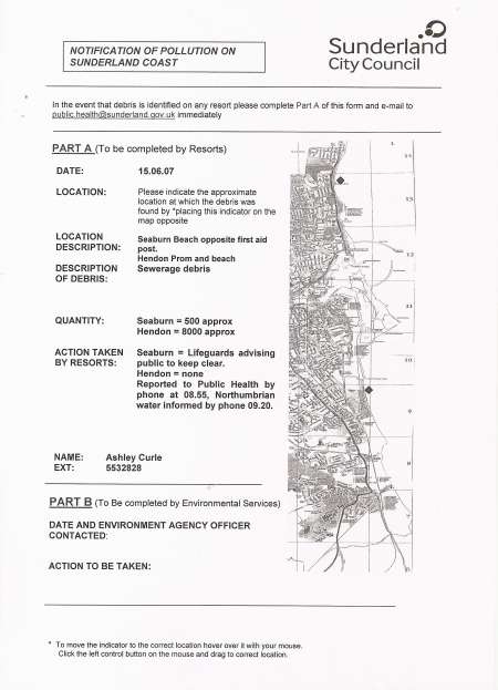
When consulting the Environment Agency record for monitoring of bathing water quality in connection with the Bathing Water Directive at Whitburn on that same date, 15th June 2007, he has found that the record shows that the monitoring result is classed as "No Result, Replacement Sample to be Taken" (See below). The question therefore arises as to why the Environment Agency sampling on this date failed, and whether an accurate record of bathing water quality at Whitburn is being recorded.
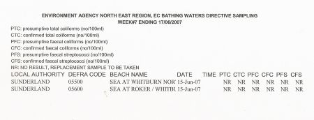
Bob Latimer has written to the Environment Agency to enquire why the sample taken on 15th June 2007 produced "No Result" and whether a replacement sample was taken on the same date. The reply from the Agency (click here) has stated that all samples have to be analysed within 24 hours, and that due to the late arrival of the 15 June sample at the laboratory it had to be discarded. Regarding whether a replacement sample was taken on the same day, the Agency has advised that another sample was scheduled for the next day (16th June) but was not actually taken until 19th June (i.e. 5 days later). The sample taken on 19th June showed compliance of the bathing waters with the mandatory standard of the Bathing Water Directive (see below).

Bob Latimer has now sent a formal complaint to the EU Commission about the administration of sampling in 2007 at Whitburn in accordance with the Bathing Water Directive, and the EU Commission has acknowledged that it is investigating.
The Marine Conservation Society (MCS) Good Beach Guide, which is based on Environment Agency records, shows that Whitburn bathing water can be subject to a storm water discharges.
Despite this, Whitburn bathing water reached the MCS Recommended standard in 2006 and 2007 (Recommended Standard = Highest water quality standard, and any continuous sewage discharges are treated adequately).
The MCS Good Beach Guide 2008 listing (i.e. based on the EA data collected during the 2007 bathing season) shows that Whitburn bathing water quality attained a basic pass (i.e. complied with the the Bathing Water Directive's mandatory standard, but not its stricter guideline standard).
Therefore the question is : if the Whitburn combined sewer overflow discharged on 15th June 2007 and the EA monitoring result on that same date showed "No Result", was the actual water quality at Whitburn being properly measured during 2007? And if it was not, did Whitburn bathing water actually pass the Bathing Water Directive's mandatory standard in 2007 and thus merit a "basic pass" listing for 2008 as recorded in the Marine Conservation Society's Good Beach Guide?
The outcome of the EU Commission investigation is awaited by Bob Latimer whose confidence is current procedures is low.
Wave machine set to be tested offshore
Eastern Daily Press of 1st September '08
An innovative machine which converts the movement of waves into electricity is set to be tested off the East Anglian coast this autumn. The wave energy prototype is going to be based about six miles off the coast of Southwold for a year-long trial and if it is successful, its design could be used for a series of offshore wave farms around the British coastline.
Essex-based company Trident Energy is behind the trial and spokesman Kate Hill said that the 12-month pilot of the environmentally-friendly scheme should be ready to start by the end of September. She said: "Trident is looking to develop a marine renewable energy system and this machine uses quite simple technology. It has one moving part which sits on the sea and generates electricity from the movement of the waves. We do not have a definite date as yet, but the sea trial should be ready to start in the early autumn."
Although the prototype machine is on a smaller scale, it is thought that a wave farm of less than half a square mile could generate enough electricity to power more than 60,000 homes and that situating wave farms around the coast could eventually provide a fifth of the electricity needed in the UK.
Trident Energy applied for permission to trial the machine off Southwold in January this year and now the prototype is almost ready to be placed out to sea. The machine is being built in Lowestoft by marine engineering company Small and Co, which has also recently been tasked with the restoration of the historic steam cargo vessel the SS Robin. Paul Kirby, co-owner of Small and Co, which is based on the banks of Lake Lothing, said that work on the prototype is expected to be finished by the end of September.
Known as Trident Energy 3, the machine consists of a small platform measuring about 15sq m supported by submerged pontoons anchored to the sea bed. Floats are moved up and down by the waves to generate power. During the trial the energy will be disposed of at the platform, but large-scale commercial wave farms would be connected to the land by underwater cables so that the electricity generated can be passed into the National Grid.
For more information on Trident Energy go to their website at www.tridentenergy.co.uk
Abandoning the best of Norfolk to the Sea
In addition to the Environment Agencies countenanced loss of the Cley Marshes, by failure to maintain the 500 year old shingle sea defence bank, we now have the abandonment of two more internationally acclaimed wildlife site, the RSPB's Titchwell, probably England's finest bird reserve, and the National Trust Blakeney Point, acclaimed as one of the ten of the UK's finest coastal beauty spots.
All are deemed to be lost, in part at least, for similar reasons to those same excuses given by the Broads Authority in contemplating the loss of many beautiful Norfolk villages, historic churches and the Broads themselves.
Read the full our full article on the MARINET website at www.marinet.org.uk/coastaldefences/bestofnorfolk.html
Even MORE Dredging?
Despite the obvious evidence of the ongoing erosion brought about by continuing offshore dredging, it would appear that there is more to come. Whilst the new area sought is a further eastward thrust of the huge dredging area already existing off Great Yarmouth, that projected for Southwold is an area far closer to the shoreline than that now being dredged, and appears to offer a greater threat of erosion to the Sizewell Bank and the nuclear power stations. The following article by Mark Lord appeared in the pages of the East Anglian Daily Times of 26th August '08.
New threat to Suffolk coast
Campaigners fighting to protect the county's coastline from the ravages of the sea said last night that plans to vastly increase the dredging zone off Southwold could dramatically "speed up" erosion. Marine aggregate companies want to dredge an area of seabed off the coast which campaigners claim would be 10 times the size of the current dredging zone being worked.
Environmental pressure group Marinet, which is part of Friends of the Earth, has warned a consortium of marine aggregate companies is considering increasing the current area used for dredging.
The newly-formed Anglian Offshore Dredging Association (AODA) has put the new area forward for discussion and is to hold a public information day on the proposals.
Marinet said AODA had not yet applied for a licence to dredge the new area but it had carried out a marine aggregate regional environmental assessment and an application was expected shortly. Pat Gowen, of Marinet and the North Sea Action Group, said: "This new area would be much nearer to the shoreline and much more localised damage would be caused to the area around Southwold much quicker than in the past. Dredging causes larger waves and speeds up erosion along our coast." He added that dredging makes the seabed steeper and weakens offshore sandbanks which otherwise would break up large waves.
Coastal protection campaigner Peter Boggis, who has built his own sea defences at Easton Bavents, near Southwold, said: "The affects of dredging are not clearly understood and the Government should adopt a precautionary principle and be sure the coast is properly protected before allowing any further dredging to take place. "It has been noted in Easton Bavents and Southwold that dredging has increased erosion in the area."
No-one from AODA or for the British Marine Aggregate Producers' Association (BMAPA), which represents most of the companies involved in offshore dredging, were available to comment yesterday. But a statement on the BMAPA website said that "by providing essential resources to replenish beaches, marine aggregates are a solution to coastal erosion rather than the cause of it. Such erosion is a natural process, driven by waves and currents that affect both beaches and cliffs."
It added: "One of the industry's key objectives is to ensure that dredging does not affect such processes; for example by changing the wave climate or interfering with seabed sediment transport. Before permission to dredge is granted, careful analysis of waves and currents in the area is undertaken using hydrodynamic models. Permission would not be given if the experts felt there was the slightest threat. As a further safety mechanism, monitoring of the seabed, and adjacent coast in sensitive areas, is also undertaken while dredging is carried out."
AODA is holding a public information day at the Vice Admiral Bar at Great Yarmouth Racecourse on September 26, with three 20 minute presentation sessions at 3pm, 5pm and 7pm.
Marinet has asked the National Audit Office to investigate whether it is cost-effective to dredge sand and gravel for sea defences when the dredging itself may be contributing to erosion.
Marine dredging is a major source of government income, raising millions every year in licences because the land is part of the Crown Estate - and millions more in VAT when the aggregate is sold. About 25million tonnes of sand and gravel are taken from the sea bed around England and Wales each year. The material is used mostly for buildings and roads, but some goes to repair sea defences and replace sand washed away from beaches.
The Growing Oxygen Depletion threat to our seas
The Guardian of Friday August 15th '08 produced this very worrying article written by environment correspondent David Adam on the growing threat of oxygen depletion to our worlds seas.
Suffocating dead zones spread across world's oceans
Critically low oxygen levels now pose as great a threat to life in the world's oceans as overfishing and habitat loss say experts.

With more than 400 oxygen-starved dead zones in global coastal waters, scientists are calling for such dead zones to be recognised as one of the world's great environmental problems. Man-made pollution is spreading a growing number of suffocating dead zones across the world's seas with disastrous consequences for marine life, scientists have warned.
The experts say the hundreds of regions of critically low oxygen now affect a combined area the size of New Zealand, and that they pose as great a threat to life in the world's oceans as overfishing and habitat loss. The number of such seabed zones - caused when massive algal blooms feeding off pollutants such as fertiliser die and decay - has boomed in the last decade. There were some 405 recorded in coastal waters worldwide in 2007, up from 305 in 1995 and 162 in the 1980s.
Robert Diaz, an oceans expert at the US Virginia Institute of Marine Science, College of William and Mary, at Gloucester Point, said: "Dead zones were once rare. Now they're commonplace. There are more of them in more places."
Marine bacteria feed on the algae in the blooms after it has died and sunk to the bottom, and in doing so they use up all of the oxygen dissolved in the water. The resulting 'hypoxic' seabed zones can asphyxiate swathes of bottom dwelling organisms such as clams and worms, and disrupt fish populations.
Diaz and his colleague, Rutger Rosenberg of the department of marine ecology at the University of Gothenburg, call for more careful use of fertilisers to address the problem. Writing in the journal Science, the researchers say the dead zones must be viewed as one of the "major global environmental problems". They say: "There is no other variable of such ecological importance to coastal marine ecosystems that has changed so drastically over such a short time." The key solution, they say, is to "keep fertilisers on the land and out of the sea". Changes in the way fertilisers and other pollutants are managed on land have already "virtually eliminated" dead zones from the Mersey and Thames estuaries, they say.
Diaz says his concern is shared by farmers who are worried about the high cost of fertilizers. "They certainly don't want to see their dollars flowing off their fields. Scientists and farmers need to continue working together to minimise the transfer of nutrients from land to sea."
The number of dead zones reported has doubled each decade since the 1960s, but the scientists say they are often ignored until they provoke problems among populations of larger creatures such as fish or lobsters. By killing or stunting the growth of bottom-dwelling organisms, the lack of oxygen denies food to creatures higher up the food chain. The Baltic Sea, site of the world's largest dead zone, has lost about 30% of its available food energy, which has led to a significant decline in its fisheries.
The lack of oxygen can also force fish into warmer waters closer to the surface, perhaps making them more susceptible to disease. The size of marine dead zones often fluctuates with the seasons. A massive dead zone, some 8,000 square miles across, forms each summer in the Gulf of Mexico as floodwater flushes nitrogen-rich fertiliser into the Mississippi River. Experts said it was slightly smaller than expected this year because Hurricane Dolly stirred up the water. Dead zones require the water to be separated into layers, with little or no mixing between. As well as fertilisers rich in nitrates and phosphates, sewage discharges also contribute to the problem because they help the algal blooms to flourish.
Diaz and Rosenberg say: "We believe it would be unrealistic to return to pre-industrial levels of nutrient input [to oceans], but an appropriate management goal would be to reduce nutrient inputs to levels that occurred in the middle of the past century," before the rise in added nutrients began to spread dead zones globally.
Climate change could be adding to the problem. Many regions are expected to experience more severe periods of heavy rain, which could wash more nutrients from farmland into rivers.
In May, scientists reported that oxygen-depleted zones in tropical oceans are expanding. They analysed oxygen levels in samples of seawater and found the effect was largest in the central and eastern tropical Atlantic and the equatorial Pacific. The increase could push oxygen-starved zones closer to the surface and give marine life such as fish less room to live and look for food. The scientists, led by Lothar Stramma from the Leibniz Institute of Marine Sciences in Kiel, Germany, say the change could be linked to warming seas. At 0C, a litre of seawater can hold about 10ml of dissolved oxygen; at 25C this falls to 4ml. Stramma said: "Whether or not these observed changes in oxygen can be attributed to global warming alone is still unresolved." The reduction could also be down to natural processes working on shorter timescales, he said.
Compensation for erosion loss?
From the 19th August '08 Eastern Daily Press comes this article by Ed Foss. As aforesaid, it might appear that a new enlightened attitude has arisen. But in needs be noted that the prime cause of the losses remains non-addressed.
Cash possible for homes lost to the sea
People faced with losing their homes to coastal erosion or flooding by the North Sea last night welcomed a breakthrough in their fight for financial compensation. A senior government adviser, the new chairman of the Environment Agency, Lord Smith of Finsbury, yesterday urged the government seriously to consider using taxpayers' money to re-house those who lose out to the encroaching sea. It is the first time anyone of such standing has responded to the pleas of homeowners not to be left empty-handed after the sea claims their homes.
His comments were given a general welcome by those living on the brink of coastal erosion, although they stressed the need for speedy action and said the government was guilty of "ongoing ambiguity" over many issues linked with the management of the coast.
Di Wrightson, who lives within yards of the receding cliff edge at Happisburgh and is likely to have to move out of her home in the coming months, said she felt the wheels of government would almost certainly move too slowly to help her, but welcomed the fact the subject of compensation had finally reached the top table of government. "I really do think they are considering compensation now - and so they should, people are set to lose what they have worked their entire lives for, having been told when they bought their houses they would be protected," she said.
There have been increasing calls by homeowners for compensation to cushion the blow of losing their homes to the sea as the government attempts to move from a policy of holding the line to one of managed retreat along many parts of the coast.
Lord Smith, a former Labour cabinet minister, named north east Norfolk and Suffolk as being particularly at risk. He did not make specific comment about the six Broads villages named in a recent, deeply controversial Natural England report which identified an option to allow 25 square miles of Norfolk to be abandoned to the sea - nor did he speak about specific communities such as Happisburgh, which has been at the forefront of coastal campaigning in recent years, or the Blyth Estuary, which is also threatened. He also left many questions unanswered about the scale and timing of any compensation deals. But his comments clearly had them in mind and were the first signs of hope for those who have campaigned for years to secure payments for those at risk from climate change and rising sea levels.
Lord Smith said ministers could no longer rely on insurance companies to cover families who lost their homes, suggesting they would have to be rehoused at the taxpayers' expense. "We need to start having a serious discussion with government about what options can be put in place," said Lord Smith, who went on to say that the north east Norfolk and the Suffolk coastlines faced the most immediate danger.
Malcolm Kerby, coordinator of the Coastal Concern Action Group, a campaign body born from the problems faced in Happisburgh but which now has a reach into communities across the country and into several government bodies, said he "took tremendous heart" from Lord Smith's words, but added that it was vital to avoid "false hope". Mr Kerby said the compensation debate was only in existence because the government wanted to introduce policy changes such as managed retreat, which were "utter madness". "To have someone at the top of the Environment Agency say these things shows that he accepts that if the government wants to pursue the policies it says it wants to pursue - which are folly in themselves - then there has to be compensation. We need a clear steer on this now, the ongoing ambiguity created by different statements from the likes of the Environment Agency, the minister Phil Woolas, Defra and Natural England is unfair on everyone."
North Norfolk MP Norman Lamb said: "I am of course encouraged by the support for proper financial compensation for communities and individuals affected; it appears some headway is being made on this subject. "But I have deep concerns about the fact people can't play fast and loose with these communities, there is a danger that what Lord Smith has said will only serve to confuse people and his words beg many more questions than they answer."
Lord Smith said the agency was already drawing up projections as to which areas of coast would be most at risk over the next 50 years.
New thoughts on approach to Coastal Defences?
From the 18th August Independent comes this item giving the thoughts of the new EA Head on our coastal defences.
'Stark warning on Britain's shrinking coast' by Nigel Morris.
Abandon homes to the rising sea, warns Britains new environment chief
Stretches of Britain's coastline are doomed and plans will soon have to be drawn up to evacuate people from the most threatened areas, the new head of the Environment Agency warns today.
In his first interview since taking office, Lord Smith of Finsbury says Britain faces hard choices over which areas of our coast to defend and which to allow the sea to reclaim. He said detailed work was already far advanced on identifying areas of the east and south coasts which were most vulnerable to erosion, and called on ministers to give emergency help to families whose homes will be lost. In a wide-ranging interview, Lord Smith, a former cabinet minister, also warns that the Government is not taking the environment seriously in a series of key projects. He says "Building a third runaway at Heathrow Airport would be a "mistake" because of pollution and aircraft noise; Plans for a new generation of coal-fired electric power stations should be abandoned until the Government is certain they will not pump out harmful gases. The proposed Severn barrage will destroy fish stocks and wreck bird habitats".
Lord Smith disclosed that the agency was drawing up projections of where sea erosion will do most damage over the next five, 25, 50 and 100 years. It is also factoring in the additional problem of the threat to low-lying areas from rising sea levels. "This is the most difficult issue we are going to face as an agency," he said. "We know the sea is eating away at the coast in quite a number of places, primarily - but not totally exclusively - on the east and south coasts. It's a particularly huge issue in East Anglia, but in quite a number of other areas as well."
Lord Smith, a former culture secretary, promised to do his "level best to try to defend communities where there are significant numbers of properties under threat and where it's possible to find engineering solutions". But he said the agency, working with ministers, would have to identify "priority areas" and warned: "We are almost certainly not going to be able to defend absolutely every bit of coast - it would simply be an impossible task both in financial terms and engineering terms." Suggesting that parts of north-east Norfolk and Suffolk faced the most immediate danger, Lord Smith promised to work closely with the communities involved to achieve as much "consensus" as possible over which coastal stretches to protect.
He said: "We will publish next year details of the work that's been done, where we think the particular threats are, where we think there is current defence in place. We will begin to talk with communities where we think defence is not a viable option." He also said ministers could no longer rely on insurance companies to cover families who lost their homes, suggesting they would have to be rehoused at taxpayers' expense. He said: "We need to start having a serious discussion with government about what options can be put in place."
Lord Smith put himself on a collision course with his former colleagues over a number of important infrastructure projects championed in Whitehall. He dismissed the Department of Transport's insistence that building a new runway at Heathrow could be environmentally sustainable. "The increases in volume of air traffic and the consequent increases in congestion on the ground are, from the analysis that we've done, pretty unavoidable," he said. "I think the Government is making a mistake and I will carry on telling them that I think they are making a mistake."
He opposed building a new coal-fired power station at Kingsnorth in north Kent - with others to follow - because he is not satisfied the promised technology to "capture and store" carbon would have been developed in time for its planned opening in the next decade. "My view would be that we should not go ahead with the development of a new coal-fired generation unless those [clean coal] technologies are in place and we can clean up the emissions."
Although he supported using the river Severn's huge tidal power to generate electricity, he said he was alarmed at the Government's support for a fixed barrier. "Effectively you would be destroying the fish populations of everything up the river system from the barrier. That is a major environmental downside."
MARINET questions MFA about Tyne Tunnel dredging disposal
The national Friends of the Earth legal department has written to the Marine and Fisheries Agency on behalf of Robert Latimer, a MARINET member, to establish whether an EIA has been done in respect of the sea disposal of the dredged material arising from the construction of the new Tyne Tunnel. To see letter, click here.
Science Reveals Heaviest Element Ever Discovered
This item has been forwarded to us from inner circles, with the advice that it is not one for the website. However, given the sensational nature of this scientific discovery, a MARINET member has requested its disclosure under the Freedom of Information Regulations. Accordingly, we have been compelled to publish.
Research has led to the discovery of the heaviest element yet known to science. The new element, Governmentium (Gv), has one neutron, 25 assistant neutrons, 88 deputy neutrons, and 198 assistant deputy neutrons, giving it an atomic mass of 312.
These 312 particles are held together by forces called morons, which are surrounded by vast quantities of lepton-like particles called peons. Since Governmentium has no electrons, it is inert; however, it can be detected, because it impedes every reaction with which it comes into contact. A tiny amount of Governmentium can cause a reaction normally taking less than a second, to take from four days to four years to complete.
Governmentium has a normal half-life of 2-6 years. It does not decay, but undergoes a reorganisation in which a portion of the assistant neutrons and 20 deputy neutrons exchange places. In fact, Governmentium's mass will actually increase over time, since each reorganisation will cause more morons to become neutrons, forming isodopes, not to mention multiple oxymorons.
This characteristic of moron promotion leads some scientists to believe that Governmentium is formed whenever morons reach a critical concentration. That hypothetical quantity might normally be called "critical mass" but, in this unique case it is known as "critical mess".
When catalysed with money, Governmentium becomes Administratium (Am), another just-discovered element that radiates just as much energy as Governmentium since it has half as many peons but twice as many morons.
British trawler captured on film dumping a fishing by-catch angers Norway
Norwegian government coastguards have filmed the crew of the Prolific, a Shetland-based trawler, openly discarding more than 5,000 kg of cod and other dead white fish, or nearly 80% of its catch. Norwegian minister for fisheries and coastal affairs Helga Pedersen, speaking to angry fishing communities in northern Norway who had seen the film, has said she will press for a review of the EU fishing policy and that she wants to ban any boat discarding fish that have been caught in Norwegian waters. The film of the incident, which occurred on 2nd August and was reported in The Guardian on 13th August 2008.
It is illegal to discard fish in Norwegian waters, but boats are forced to do so in European Union waters if they have caught the wrong species of fish or fish that are too small. Last year the EU estimated that between 40% and 60% of all fish caught by trawlers in the North sea is discarded. The practice of dumping is widely recognised as unsustainable but inevitable given the present EU quota system. UK fish experts say the practice of discarding fish is common but has rarely been so dramatically documented. Opinions are split on whether the Prolific was discarding fish for which it had no quota, or whether it was "high-grading" its catch. This involves boats discarding low-value small fish to make room for high value larger fish.
In The Guardian report, Willie Mackenzie, Greenpeace fisheries campaigner is quoted "It is a disgrace. This practice is depleting populations that are already overfished and it is happening everywhere. All of these fish are perfectly marketable, and have been legally caught. But if you are a fisherman it makes more economic sense to take boat to market with the most saleable fish, so you discard the lowest value stuff."
In the same Guardian article Helga Pedersen, Norway's minister for fisheries and coastal affairs, is quoted "Discarding fish not only means a massive waste of food and potential income, it also leads to unrecorded catches, resulting in a poorer scientific basis for our management decisions. I want a requirement that all fish caught in Norwegian waters, also by foreign vessels, must be taken to port, regardless of which final port is used. We will introduce new requirements, as a condition for obtaining licenses to fish, that vessels cannot discard valuable fish caught here". And Reidar Kaarbø, an independent analyst of Norwegian government policy, comments "This must stop now. The EU community cannot be taken seriously if it allows this kind of behaviour. This is certainly not how to manage the world's resources."
The International Council for the Exploration of the Sea (ICES), which provides scientific advice to governments on the size of fish populations, has repeatedly advised the EU that stocks of cod in the North Sea are much too low to be fished and has argued for no-go areas. However, every year the European government ministers override their advice and continue with a quota system. A spokesman for the Department of the Environment, Food and Rural Affairs (Defra) is quoted in The Guardian article: "Throwing dead fish back into the sea is a waste that nobody wants to see, but there is no easy answer. The UK is keen to ensure more effective and sustainable fisheries by reducing by-catch and discards, and the government is working closely with fishermen to achieve that."
European Environment Agency creates interactive map for Bathing Waters
The European Environment Agency (EEA) has created an interactive map for the public which displays the latest information on the water quality in bathing sites across Europe. The new map also allows the public to rate beaches and to share their comments with others. The EEA state in their Press Release, 30th July 2008 "Every year, millions of Europeans spend their summer vacations by coastal or inland waters. The quality of the bathing water at their destination can be a key factor in deciding where to go. Now with Eye on Earth (the interactive map), holidaymakers will not only be able to check the latest information available on the water quality at their possible destinations, but also read comments posted by others who have already been there.
The interactive map can be accessed here.
Global Warming Threat to our Coastline
The Daily Mail of 7th August 2008 reports this item.
Temperatures could soar 4C in Britain putting coast at risk, warn top scientists
Britain should prepare for the consequences of a 4C rise in temperatures, one of the Government's chief scientific advisers said today. The UK and EU are attempting to limit global warming to no more than a 2C temperature rise above pre-industrial times to avoid dangerous climate change.
But Professor Bob Watson, the chief scientific adviser to the Department for the Environment, Food and Rural Affairs, said there was a good chance that Britain will face a 4C rise. Soaring temperatures could lead to a retreat from the coast, Sir David King has warned. '"There is no doubt that we should aim to limit changes in the global mean surface temperature to 2C above pre-industrial" Prof Watson told The Guardian. "But given this is an ambitious target, and we don't know in detail how to limit greenhouse gas emissions to realise a 2C target, we should be prepared to adapt to 4C."
His concerns were echoed by the Government's former chief scientific adviser, Sir David King. He said that a two-and-half-year analysis on the implications for coastal defences had a major impact on government thinking about the effects of climate change, with officials even considering one day having to retreat from parts of Britain that it cannot protect from rising sea levels. "'No other single factor focused the minds of the Cabinet more than the analysis that I produced through that ... We begin to have to talk about ordered retreat from some areas of Britain because it becomes impossible to defend" he said.
The soaring temperatures would impact on agriculture, coastal erosion and flood protection. It would also put hundreds of millions of people in small islands and coastal cities such as London and New York at risk of flooding because of rising sea levels. To emphasise the impact of a 4C rise, the report states that we are now only around 5C warmer than in the last ice age.
Sir David warned that even with a comprehensive global deal to keep carbon dioxide levels in the atmosphere at below 450 parts per million there is a 50 per cent likelihood that temperatures would exceed 2C and a 20 per cent probability they would exceed 3.5C. "Even if we get the best possible global agreement to reduce greenhouse gasses on any rational basis you should be preparing for a 20 per cent risk so I think Bob Watson is quite right to put up the figure of four degrees" he said.
Thoughts on abandoning our coastal defences
Libby Purves thoughtfully wrote the following column in The Times on November 13th 2007. Although now almost a year ago, it has more relevance today than ever.
Don't give up on sea defences
It is strange when the sun shines on days of meteorological crisis. It happened here in Suffolk after the '87 hurricane, glorious blue-and-golden days illuminating a chaotic landscape of fallen timber and sparking power lines. On Friday morning too it shone, as the storm surge drove great hammering, spouting fists of water up against sea walls, drowned quays and turned the A12 into a shining extension of the Blyth estuary. Early in the day the sea wall at Aldeburgh, a thin battlement between rising brown river and hammering waves, felt like the only place to be. There is fear and loss and inconvenience in these great natural events, but there is also exhilaration.
Exhilaration - and relief - should not be taken too far. It is true that nobody died and only a few homes were flooded (though the Broads were hit, bitterns may not nest next year and the Harbour Inn lost its kitchen). Most of those evacuated went home to dry houses. Helicopters and loudhailers proved unnecessary. We got away with it.
But the local fear now is of complacency, and that government will sit back with a sigh of relief and forget how close it came. The main surge went through at 3.30 in the morning at low tide; had it been six hours later, coinciding with high water, it would have been a catastrophe.
John Gummer, MP for Suffolk Coastal, is outspoken about the policy described on the Environment Agency document as "making space for water", and accuses it of deliberately writing off villages and land. A hasty denial yesterday from Defra said there is no general policy of this kind, but used the word "sustainable" and "prioritised" too often to comfort those who know perfectly well they are not priorities because population is scanty and farmland considered expendable. The Environment Agency admits that the funding constraint "... does mean withdrawing protection in rural coastal areas".
Mr Gummer calls it an immoral decision: "We have been defending this coastline for thousands of years and this is the first government to decide that we will give in. While Holland is defending every square inch, we are intending to give up large acreage of land which we desperately need for food security as well as houses... Could it be that there are no votes for them on the coastline?"
Be that as it may, he has a point. Whitehall's shrugging fatalism is not only upsetting to communities but out of date. Arable and grazing land, for decades seen as a luxury because imported food was cheap, is becoming something to treasure. The biofuel boom and the rising appetites of India and China for meat and milk are just beginning to bite. Giving up land - or letting it degenerate into marsh nature reserves - is less wise than it seemed ten years ago. So is the abandoning of housing land in Eastern counties with a rocketing EU immigrant population.
It is not cheering to those in poor, low-lying lonely areas to be told that they don't matter. Or even that their environment doesn't: there is considerable angst about what will become of our small rivers if defences are not maintained (last year the Environment Agency publicly gave up on the Blyth because "the cost of repairing defences outweighs the benefits").
Above all there is a general sense of frustration at the Olympian attitude from London. Landowners who live close to the problem all year round claim that the flood defences are in better condition than the Environment Agency claims. Sir Edward Greenwell, of Orford, says: "The defences are very robust. They have stood up well and we need to make clear that they are maintainable; we do not have to walk away from them." Another farmer observed that "the cost of maintaining these walls, which were built 300 years ago, is minimal compared with the money the agency has spent on consultants who recommend the defences be abandoned". Peter Boggis, the rebel of Easton Bavents, is fighting in the courts against the refusal by Natural England to let him go on maintaining a home-made sea wall near his home.
The thread running through all this is of anger and fear that distant decisions always overrule local feeling; and that Defra is no more fit to make decisions about sea defences than it proved fit to maintain a simple bit of pipeline that would have prevented the escape of foot-and-mouth disease from its own laboratory (which incompetence cost, incidentally, years' worth of coastal defence money).
Country people accept the inevitability of erosion. Our house sits a mile back (a shrinking mile) from the coast at Dunwich, once a great port city and now a hamlet. Farmers - not bureaucrats - will recognise the right time to abandon a grazing meadow that has become salt. These are practical people.
Not all the handling has been bad. The Environment Agency's early-warning system worked. The emergency services were ready. But unease persists: there is no real accord between the local authorities and the Environment Agency. One comment by a member of the public in Sudbourne village hall last week had a universal resonance: "The agency are servants of us, we are not servants of them. We will not be dictated to." It wasn't nicely printed consultation documents and a dawn Cobra meeting and the smiling Mrs Follett popping up for a photo-op at Great Yarmouth docks that saved us on Friday. It was a lucky tide and a wind shift.
Of course one day the sea will win; but Mr Brown is looking for a motto and I have one to commend to him. It is borrowed from the Mississippi River Engineers at Vicksburg, who work diligently to prevent their rowdy charge from flooding settlements and leaving others stranded. They too know that the river will win in the end, but they bear on their crest the one-word motto: Essayons. Let us try.
Record-sized Crab caught in Lyme Bay
The largest recorded edible crab has been caught in Lyme Bay, Dorset. It weighed 17lb and had a shell width of 12in, with each of its massive claws being as big as a man's hand. The previously largest crab of this species had a carapace 11in wide and is in the Museum National d'Histoire, Paris. The Lyme Bay crab will not however be going to a museum. It has been eaten. The catch underlines the marine conservation importance of Lyme Bay, 60 square miles of which have just been granted conservation protection by the UK Government.
For further details of this story, published in The Daily Mail, 3rd July 2008
For additional information about crabs and their life-cycle, see www.marinet.org.uk/mreserves/marineanimals.html
Company established to sell Cornish sea salt
The Cornish Sea Salt Co, which has been operating for less than six months on the Lizard peninsula - mainland Britain's most southerly tip - is aiming to produce 150 tonnes of salt this year and eventually build up to 500 tonnes annually. The business has been established by Tony Fraser, and people who have tasted the salt have praised it for its strength. There are two other well-known sea salts produced in Britain: Maldon sea salt, which is produced from water drawn from the Blackwater estuary in Essex, and Halen Môn sea salt, which uses seawater from the Menai strait in north Wales.
For full details of this story, published by The Guardian on 28th July 2008
New idea for wave power generation
A two year project at the University of Southampton is researching the generation of electricity using a giant rubber tube closed at both ends, filled with water and anchored in the sea with one end facing oncoming waves. Named the Anaconda, it relies on "bulge" waves, which form inside when a passing wave squeezes the tube. As the bulge wave moves down the tube, the wave that caused it runs along the outside at the same speed - making the bulge wave inside grow even bigger. This action turns a power-generating turbine at Anaconda's far end.
Read more at the Guardian 7th August 2008
Lyme Bay protected area to be monitored by Univ. of Plymouth
Following the recent decision by the UK Government to create a 60 square mile exclusion zone in Lyme Bay, amounting to around 10% of the Bay, (see, www.marinet.org.uk/latestnews.html#uga2 ), the Government has awarded a contract to monitor the impact of the ban to The University of Plymouth, in association the Plymouth Marine Laboratory and the UK Marine Biological Association. Further details are explained in the following Press Release issued on 28th July by The University of Plymouth (www.plymouth.ac.uk/pages/view.asp?page=23538)
Plymouth Scientists Secure Lyme Bay Contract
A group of marine scientists, led by the University of Plymouth, has secured a major Defra contract to monitor the ecological and socio-economic impact of the Lyme Bay 60 square mile exclusion zone.
Almost ten per cent of Lyme Bay, one of Britain's richest marine habitats, has been permanently closed off to scallop dredging and bottom trawling in a bid to protect the area's reef habitats, home to a wide range of marine biodiversity including rare pink sea fans, sunset cup corals and rare sponges. The move, imposed by Defra (11th July 2008), is the country's largest ever closure of a marine area to protect wildlife.
The University of Plymouth, together with bid partners Plymouth Marine Laboratory and the Marine Biological Association of the UK have been contracted to monitor the impact of the ban - by assessing the recovery of the marine wildlife and analysing the social and economic impacts on the affected communities.
Over the next three years, the team of experts will use state-of-the-art underwater video technology to monitor and record the change in abundance, size and biomass of various marine species and compare these with areas where fishing is allowed to continue. The findings will then act as a conservation tool to inform future environmental management of marine areas in the UK and marine spatial planning in the South West region.
The impact on the affected local communities will be examined by reviewing current social and economic issues and interviewing local stakeholders about their perceptions. A cost benefit analysis will then be conducted to help improve the level of understanding of the social and economic impacts of marine protected areas. The information collected as part of the study will help inform the completed of future Impact Assessments.
Professor Martin Attrill of the University of Plymouth is coordinating the bid. He says Defra have chosen the best possible team for the job; "The contractors within the tender for this project - the University of Plymouth Marine Institute, Marine Biological Association and Plymouth Marine Laboratory are all within the Plymouth Marine Sciences Partnership which has a unique ability to undertake this work in Lyme Bay. PMSP has an unparalleled experience of the ecology, fisheries and socio-economics of the Lyme Bay area, with a range of ongoing projects from the health of Pink Sea Fans to assessing the economic and ecological value of the habitats for marine conservation. We can also deploy state-of-the-art underwater video and diving facilities backed up by high levels of expertise in the marine biology, ecology and socio-economics of the area."
The team already has an established relationship with many local stakeholder groups including Devon Wildlife Trust, Finding Sanctuary, Devon Maritime Forum and Devon Sea Fisheries Committee and is committed to working closely with such organisations to allow direct stakeholder involvement and provide avenues for continual knowledge transfer.
Joint Committee of Parliament recommends changes to Draft Marine Bill
Throughout June and July a Joint Committee of MPs and Peers has been involved in its own deliberation and the hearing of evidence concerning the Government's proposals in the Draft Marine Bill. The Bill is due to come before Parliament following the Queen's Speech in the autumn. On 30th July the Joint Committee published its own Report, see the full text here.
The Joint Committee has given careful consideration to the role of marine reserves in the forthcoming legislation. It has recommended to the Government that:
- There should be a duty on the Secretary of State to create a network of Marine Conservation Zones (MCZS), and that provisions for these protected areas should be strengthened in the Bill.
- The MCZs should be established as a network, and that this should be explicitly stated in the Bill in order to ensure that MCZs are not just isolated areas.
- There should be a timetable for the designation of this network of MCZs.
- The network of MCZs should be underpinned primarily by science, thus giving the network ecological coherence.
- The MCZs should display a range of levels of protection, allowing multiple uses to highly protected reserves.
- The Government should negotiate the removal of historic fishing rights that other EU countries have in UK seas and ensure that conservation measures, such as restrictions on fishing, can be properly enforced.
MARINET submitted written evidence to the Joint Committee, see www.marinet.org.uk/marinebill.html and is greatly encouraged by the response of the Joint Committee. MARINET wants the Marine Bill to place a duty on the Secretary of State to create an ecologically coherent network of highly protected marine reserves covering 30% of UK seas out to 200 nautical miles by 2015. Therefore, the support of the Joint Committee for a duty on the Secretary of State, and for a timetabled designation of a network of reserves underpinned by science and thus displaying ecological coherence, is viewed by MARINET as an important step forward.
What remains to be achieved is that this network of reserves should be seen as a primary tool for the management of the whole marine ecosystem in UK seas, and that this network of reserves should be given highly protected status and cover 30% of UK seas out to 200 nautical miles. Such a primary, marine reserve focused management tool will be essential to achieve "good environmental status" for UK seas as required by the EU Marine Strategy Framework Directive, (see details here) and the figure of 30% is affirmed to be essential both in a petition signed by a 300-strong body of EU marine scientists led by Prof. Callum Roberts, York University, and by the UK Royal Commission on Environmental Pollution in their 25th Report, Turning The Tide. Currently just 2% of the UK seas are protected, with less than 0.002% afforded full (highly protected) status.
To see the full text of the MARINET submission to the UK Government (Defra) with regard to the Draft Marine Bill and how MARINET believes it should be amended, see www.marinet.org.uk/marinebill/marinebillsubmission1.pdf
MARINET member explains storm sewage problem at Whitburn
Robert Latimer explains how combined sewer overflows (CSOs) are causing a serious pollution problem on the beach and in the sea at Whitburn, near Sunderland. Normally rain water from roads and paved areas is collected by a separate sewer from the one which collects sewage and foul water. This means that when heavy rain occurs the rainwater sewer can store the storm water and, if necessary, overflow into a river or the sea without causing serious pollution. However, in many places, the rainwater and foul sewers are combined which means that when heavy rain occurs and an overflow is required, the combined sewer overflow into the river or sea causes serious pollution. Water Companies, under their capital investment programmes funded by increased annual water charges, are meant to be eliminating the practice of combined sewers.
Robert Latimer writes : "This is a short explanation of how a Combined Sewer Overflow (CSO) licence operates, and how I became involved in trying to find out what was being dumped in the sea.
"Out of the blue I was approached by Northumbrian Water (NWL), and they explained that due to an EU Directive they had to build a storm water pumping station next to our property (within 15meters) at Whitburn. They explained that I had no need to worry as it would only operate in severe weather conditions and would only discharge storm water, at most, 20 times a year. In fact they told me it was a waste of EU money and was really not needed. I went along with what they said, being reassured that for 99% of the time nothing would be going down the pipes. I had no reason to doubt what they were saying, and so I did not object to the project.
"When the pumping station came into operation I quickly found that it was not discharging storm water, it was discharging foul sewage. So much so that in the year 2000 the Environment Agency (EA) records show that it had discharged over 1,207,000 cubic metres. In other words, over one million more cubic metres than had been estimated in the consent (licence). In fact it was discharging every day, even when there was no rain let alone a storm.
"I brought this to the attention of the Environment Agency who reluctantly agreed that the discharges were breaching the licence conditions. This resulted in Northumbrian Water Ltd having to apply to the EA to amend the licence. I opposed the amendment asking the Secretary of State to call in the application which she did, resulting in a Public Inquiry.
"It was at this point that the EA showed their real colours employing a barrister to have the scope of the Inquiry reduced. This resulted in the Inquiry being a mere whitewash, failing to investigate the real reasons why so much foul water was being discharged, and allowing the EA to issue a new consent to Northumbrian Water which allowed more to be discharged in one day under certain conditions than the old consent and the Environment Agency had said originally would be discharged in a year.
"The real reason I mention this is because I believe Whitburn cannot be unique. I do not believe that the Whitburn CSO is a one off, but rather shows how these CSOs are out of control, with more sewage being discharged from them than is being treated through the treatment works. Furthermore the Environment Agency, the very people who you think will protect you, are allowing it.
"But last night (31st July 2008) was different. We had a storm. The EA say it was 'severe rainfall,' the very conditions Whitburn was built to handle - I enclose the photographs to show what took place . . . manholes blown off, flaps on the beach bursting open, sewage debris hanging out off manholes, tarmac ripped up, the very situation Whitburn Storm system should take in its stride. The CSO tunnel has a 14,000 cu metre capacity for storing storm flows, yet it failed miserably as you can see by the photos.
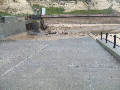
"I ask all Marinet members to request, from the Environment Agency, copies of the discharge records from these so-called CSOs in their areas, and let us compare.
"The phone started ringing at 7am this morning, people contacting me, rather than the Environment Agency, about the sewage on the beach. I contacted the EA by email - "You can see the sewage debris trapped in the lid of this manhole showing that the pumps had not stopped pumping forward to St Peters which was already discharging into the river, - I asked the EA why is this taking place?
"This was the EA reply - "I refer back to previous correspondence in which we have made it clear that we will not enter into any further discussion with you on matters relating to the Sunderland sewerage and sewage treatment system""
An additional comment on this situation is provided by Eddy Moore, a MARINET member who lives on the coast at Hendon, near Sunderland.
Eddy Moore writes: "I would like to add to Bob Latimer's comments regarding Whitburn and the functioning of the CSOs. I live at Hendon, south of Sunderland. I would like to give my account about Sunderland and its sewage system which we have been told is a 'State of the Art System', costing £70 million. In reality my observations, supported by complaints logged with the Environment Agency, have shown that time after time sewage debris is coming ashore in a manner worse than under the old system, and this has persisted since the new 'State of the Art' system was commissioned 8 years ago.
"Recently, after raising some questions with Northumbria Water and the Environment Agency and some protracted correspondence with them, it has been admitted that Northumbria Water are having to spend a further £8,157,049 on the combined sewer overflow system at the Sewage Treatment Works. This situation now is that Northumbria Water is fitting further screens to remove the sewage debris and this work is housed in a large new extension building. It appears that the company is also digging up what seems to be the whole overflow part of the system.
"It is my belief that it is my actions that have brought about this modification. I have fought for this for 12 years, whilst the Environment Agency has sat back and done nothing but hinder me, and now the EA wants to charge me £600 for information that proves it has been negligent. As Bob Latimer has observed, when we exposed the pollution that is occurring and managed to get a Public Inquiry, the Environment Agency employed a barrister to have the scope of the Inquiry reduced so that it did not investigate the combined sewer overflow (CSO) situation.
"I believe that MARINET members and the public must take up this issue regarding screening and the operations of these CSOs otherwise the life in our seas locally will be lost altogether. I ask for all members to help expose what is going on."
Undercurrent Stabilizers under Consideration?
Peter Waller advises that it appears that some of the new technology for lower cost but more effective coastline protection may now be under consideration. He sends in the following clip from Patty Brown in Florida. Its source is taken from a short report prepared by Halcrow for Sea Palling on the Happisburgh to Winterton Project Stage 3b.
"The possibility of adopting an alternative form of beach management structure would need to be considered at Strategy level, and therefore cannot be considered as part of the current PAR for works under the existing Strategy. It is recommended that these structures are considered at the next Strategy Review. At this time it is recommended that an outline review of the potential cost of implementing a scheme is carried out to consider the economic viability of such a scheme when compared to the present value cost of implementing works as recommended by the current strategy. Dependant upon this initial review a full assessment of the effect on coastal processes may be required. "
There is a most interesting film of marine matters in WFLA-NBC's "Bob Hite's 8 Country" Report covering the Tampa Bay area coastline environment. In particular part of it looks at the history and present state of Egmont Key State Park and how it is being lost to coastal erosion due to mans dredging and port deepening activities. From 26 minutes until 30 minutes into the film it features four minutes on Dick Holmberg's method of coastline restoration using underwater stabilizers, showing coverage of coastlines) before and after the introduction of his beach stabilising technology.
The film may be viewed by going to www.tbo.com/video/xml/MGB8KM3G3IF.html
The problem is, how do we manage to get our coastal authorities awareness of this and to at least put into place one trial so as to determine the efficacy to a level of their own conviction? It appears to be of far lower cost, hence affordable, unobtrusive and sustainable, and furthermore not parasitic upon adjacent areas of the coast.
Europe to the Rescue?
'Euro help to save land' from the Lowestoft Journal of 2nd August '08
European funding could soon be available to protect land and homes in north Suffolk which are to be abandoned to the sea. East of England MEP Geoffrey van Orden, met flooding and erosion experts from the East of England Development Agency (EEDA) in a bid to secure funding to protect the Blyth estuary.
Mr van Orden, who took a boat trip around the estuary in February to see breaches in the walls for himself, said that the meeting in Cambridge was a success and he is now working towards putting in a formal bid for regional development funding. He said: "We have now got to identify a partner in order to meet the criteria to bid for money. There are a lot of interested parties, from France and the Netherlands as well as the UK. Those countries are affected by similar problems and have similar concerns. I'm looking for practical assistance - we have been battling for a long time, now we want to see something happening. I am determined to make some progress."
The Environment Agency plans to stop maintaining defences around the estuary in the next 20 years, which will leave thousands of acres of farmland, about 40 homes and the A12 Lowestoft to Ipswich road at increased risk of flooding. The agency says it would cost millions of pounds to go on repairing the walls and that the work will be unsustainable as a result of climate change, rising sea levels and the increased frequency of tidal surges.
The campaign to maintain flood defences around the Blyth estuary stepped up a gear earlier this week when hundreds of protestors formed a human chain along Southwold promenade, calling on prime minister Gordon Brown to take their concerns seriously. Mr van Orden, who was at the Southwold protest on Wednesday, said: "A lot of people are very concerned about this issue, and quite rightly. We have got to get the government to take a real interest in this."
He is going to meet with flood defence experts from Holland and other low-lying parts of Europe later in the summer to find out more about the strategies and technologies they use to protect coastal towns and villages which are threatened by the sea.
Australian anti-dredging group bankruptcy threatened by government
An Australian equivalent of MARINET is the 'Blue Wedges' Group, website www.bluewedges.org
Being concerned at the wide range of environmental, social and economic risks that would result, the Blue Wedges group have long been engaged in a campaign to stop the channel deepening of Port Philip Bay by the The Port of Melbourne Corporation, who wish to see 14 metre draught container vessels and oil tankers utilizing the port.
Penguins, dolphins, seals, sharks, whales and thousands of marine plants and animals interactively rely on Port Phillip Bay. The Bay is a largely enclosed body of water which behaves more like a lake, being extremely shallow (< 8 metres) for most of its 1950 square kilometre area. Its ecosystem relies on high levels of light penetration. High turbidity levels from extended periods of dredging threatens its unique nutrient cycling process. Independent scientists advise this delicate balance IS under threat.
Further, over 100 sponge species at The Heads occur nowhere else on earth and could be lost forever if this project proceeds. Victorian National Parks Assoc. and Australian Conservation Foundation have recently applied to the Federal government to list these unique species as needing protection from dredging threats.
Blue wedges say that almost 4 million m³ of Yarra sediments containing heavy metals such as Cadmium, Mercury, Zinc, Lead and Arsenic and Ammonia would be dumped in the Bay with contaminants likely to re-enter the food chain. Risks to human health from swimming and consuming fish from the Bay have been understated, as have risks to other Bay species. They add that 20,000 Phillip Island penguins rely on Port Philip Bay for winter feeding. Their diet is mainly anchovy which spawn in the Yarra mouth. Extensive Yarra dredging will affect anchovy survival. The Phillip Island penguin parade is reportedly Victoria's largest tourism earner and would suffer if penguins starve.
Now comes an interesting caveat for all of us who seek to halt the dredging industry's negative influence on our environment and governments, as an item in the July 18th 2008 edition of 'Sand and Gravel News' entitled 'Blue Wedges to be sued following failed Melbourne legal challenge' to be seen by visiting www.sandandgravel.com/news/article.asp?v1=11140"
It reads:
"The Australian newspaper reports that Australia's Environment Minister Peter Garrett has confirmed he will pursue costs against the Blue Wedges protest group over its failed legal challenge to the dredging of Melbourne's shipping channel.
Said the report: "The move threatens to bankrupt the anti-dredging group, but Mr Garrett has said the Commonwealth must pursue the hundreds of thousands owed to taxpayers from the case. The Government has an obligation to pursue debts under the Financial Management Act and that is the basis on which we are acting at the moment," a spokesman for the minister said.
The Brumby Government and the Port of Melbourne, which also won their costs after Blue Wedges's legal challenge was thrown out by the Federal Court, said they had not decided whether to enforce the costs order. Both parties actively pursued an order for costs during the case.
Federal Court judge Tony North ordered Blue Wedges to pay its opponents' costs on Tuesday after finding its legal challenge to the A$1 billion dredging project was not strong nor novel enough to warrant sparing them the usual obligation for losing parties to pay. "There are no sufficient special circumstances which would justify departure from the general rule and the respondents are entitled to an order that the applicants pay their costs," Justice North said.
Comment
We are only too aware of the environmental record of the current Australian government by their failure to support cuts in CO2 emissions, and also well aware of the powerful lobby of the dredging industry. This is a further example of how short term monetary profit is held in greater esteem than environmental conservation, and how big money and powerful lobbying can win the way.
Continuing Sewage Pollution of Beaches
Three articles from The Sunday Times of 3rd August 2008 spilling the beans on the fact that Britains beaches continue to be polluted by sewage from the many CSOs (Combined Sewer Outfalls) that have not been updated since their installation in Victorian times despite far higher population discharges.
View the three articles on MARINET's website at www.marinet.org.uk/ukbw/cso.html
More hype on coastal flooding?
The government continues to prevaricate on the provision of funding for our flood defences. The press item following appears to relate to reducing the consequences of such flooding, with nothing noted regarding the prevention of the threat. As for the quote "The government is launching a consultation into the scheme"; are we to have yet another action postponing 'consultation' following that already undertaken when over 99% of those consulted totally rejected the proposals of the SMP?
The Eastern Daily Press of 31st July gives the latest statement by Environment minister Phil Woolas.
New flood grants scheme
The government announced plans yesterday for a £5m scheme which would provide grants for people at a high risk of flooding to help protect their homes. The initiative could provide homeowners with a free flood survey and grants towards the cost of installing flood-protection measures, the department for environment, food and rural affairs (Defra) said. The funding would support households at a high risk of being flooded but which are not protected by community defences. But the money would be focused on urban areas, such as Hull, which have recently been flooded, rather than coastal areas like the Blyth estuary in north Suffolk which are currently protected but which will be at a high risk of flooding in future.
The government is launching a consultation into the scheme. Environment minister Phil Woolas said yesterday: "Traditional community-level defences are not a viable answer to flooding in all areas but individual households can make a big difference themselves by protecting their properties. Measures such as door-boards, air-brick covers, waterproof walls and floors and raised electrics can all reduce any potential damage caused by floodwater. Research suggests that these measures can also cut the costs of flooding by 50 to 80pc. They can halve the amount of time it takes to dry out and repair a property"
MARINET on Radio-5 Live
MARINET got a short spot on Radio-5 Live on the morning of Saturday, 26 July 2008, when Pat travelled to sadly eroded Winterton-on-Sea for a live on site interview. Here follows the BBC web page that appeared following the programme radio transmission.
They got it wrong with their précis, as I actually said " ... only five bungalows of an original ninety-eight now remain between here ('here' being the Winterton Beach Café to the south-east of Winterton Village) and Hemsby Gap, the others, including my own, taken by the sea"
A number of recently arrived Winterton Village residents were quite alarmed, as they thought that these losses had resulted to housing in the village itself!
Dredging 'causing erosion' claim

Sand and gravel are lifted from the sea bed during dredging
Villagers in Norfolk say coastal erosion is being made worse by off-shore dredging. They claim holes left in the sea bed from ships extracting gravel and sand are being refilled with sand from the shoreline of their local beaches. But Mark Russell from the British Marine Aggregate Producers' Association said research disproved these claims.
Pat Gowen, from Friends of the Earth, says 96 bungalows have been lost at Winterton-on-Sea, including his own. Mr Gowen told the BBC: "We're giving them (the government) the scientific evidence - all the research that is done all around the world, which is independent and not done by those representing the dredging companies. And we think, just like smoking, nuclear power and mobile phones, that eventually, we shall probably win and they will see that this dredging is having a serious impact on the coast and indeed upon fishing."
Mr Russell dismissed the claims, responding: "The scientific evidence demonstrates very clearly that modern marine aggregate dredging operations in UK waters do not contribute to coastal erosion. "They're far too far offshore, generally 8km off the coastline and also in far too deep water - 20m plus. If there was any doubt this activity would simply not be permitted by government."
Another Coastal Demonstration
From the Eastern Daily Press of 30th July 2008 comes this story of the increasing protests by those opposing the losses imposed by the governments unsustainable policies on coastal protection.
It is interesting to note that the EA are rock bund protecting only one house along this stretch of coastline, and that happens to be the abode of Environment Minister Hilary Benn.
Coastal protest sends message to PM

Protestors at Southwold today
Hundreds of campaigners today formed a human chain along Southwold's promenade to send a message to Gordon Brown about the Government's policy of abandoning the Suffolk coast to the ravages of the sea. The Blyth Estuary protestors - who are angry about the Environment Agency's plans to withdraw funding for flood defences at the Blyth Estuary - took their fight to Mr Brown, who is currently enjoying a summer holiday in the area. The protesters linked arms and chanted "SOS" while some held banners saying: "Gord Help Us. Save Our Shoreline."
Mr Brown, his wife Sarah and sons John, four and Fraser, two, are currently staying at Shadingfield Hall, near Halesworth, and will spend the next two weeks enjoying the beauty of the Suffolk coast.
However, after the Environment Agency announced last year it can no longer financially justify the protection of the Blyth Estuary from flooding and that it will now carry out a policy of managed retreat, much of the landscape currently being enjoyed by the Prime Minister and his family will disappear in the coming years.
Sue Allen, chairman of the Blyth Estuary Group, said: "This was a fantastic turnout and sends a tremendous message to Gordon Brown that we are committed to saving the Blyth. I want to thank everyone for their support without you this would not happen."
Supporter Karen Solloway added: "It is truly amazing how many people turned out for this, people living around here are fantastic when the call goes out for support they just get on with it and something like this protest happens." Margaret Grayson, who has been coming to Southwold for more than 70 years, said: "Mr Brown and his children are holidaying near here and enjoying what the Suffolk coast has to offer, he wants to stop and think about what the Government is suggesting for this area. If he doesn't act now then his children's children will not be able to come here and experience what the Brown family are enjoying today."
Government confirms it has sovereignty over UK fisheries only out to 6 nautical miles
In response to a written parliamentary question from Bill Wiggin MP, Shadow Minister for Agriculture and Fisheries, the Minister for Fisheries at Defra, Jonathan Shaw MP, has confirmed that the Secretary of State, and Welsh and Scottish Ministers, only have powers to control fishing out to the territorial limit of 6 nautical miles. In waters between 6 and 12 nautical miles UK Ministers must have their decision to restrict fishing approved by the EU Commission or a Decision of the EU Council of Ministers, and beyond 12 nautical miles the UK Government must seek to have restrictions agreed by the EU Commission under the terms of the Common Fisheries Policy.
MARINET observes that whilst these statements are true, and that the UK has surrendered sovereignty over the management of fisheries to the EU under the Common Fisheries Policy, the UK has not surrendered management of the UK seas, including the health of the marine ecosystem, to the EU. This retention of sovereignty is confirmed within the nature and structure of responsibilities for the management of UK seas set out in the EU Marine Strategy Framework Directive which can be viewed here. MARINET has obtained legal opinion which confirms that the UK can restrict unsustainable and damaging fishing practices in UK seas beyond 6 nautical miles (i.e. out to 200 nautical miles) provided that such management action is taken within the context of managing the marine ecosystem as a whole. This is precisely the basis upon which MARINET has been urging the UK Government to create highly protected marine reserves covering at least 30% of UK seas out to 200 nautical miles. (Click here to view MARINET's latest submission to Defra in connection with the current public consultation on the Marine Bill).
For a sight of the full text of the written parliamentary question from Bill Wiggin MP and the reply from Jonathan Shaw MP, please click here.
Government says marine reserves will cover 8.2% of UK seas
Jonathan Shaw MP, Under Secretary of State for Fisheries and Marine affairs at Defra, has stated in reply to a written parliamentary question from Bill Wiggin MP, Shadow Minister for Agriculture and Fisheries and Conservative MP for Leominster, that the UK Government is planning to create 92 Marine Conservation Zones (MCZs) in English territorial and UK offshore waters following enactment of the forthcoming Marine Bill, and that these MCZs will cover 8.2% of UK waters out to the limits of the UK continental shelf (200 nautical miles). These reserves will cover approximately 71,000 square kilometres.
In contrast, MARINET is calling upon the UK Government to designate at least 30% of UK seas out to 200 nautical miles. Also, MARINET is calling for these to be highly protected reserves which prohibit all extractive activity in order that the reserves may be used as a management tool to regenerate the whole marine ecosystem. The UK Government is not giving a similar commitment, and will continue to allow extractive activity in many of these reserves. In addition, there is no evidence in the UK Government's proposals that these 92 MCZs will form an ecologically coherent network, thus enabling them to be used as a management tool to regenerate the marine ecosystem throughout UK seas. Rather, MARINET fears that these 92 MCZs will simply protect specific rare habitats and species. Whilst such protection is important, it only constitutes a "crown jewels" approach and has little ecological coherence. Without such coherence, these MCZs will not be able to seriously address the continuing decline in biodiversity in UK seas, nor the collapse in the existing structure of the marine ecosystem threatened by continued unsustainable commercial fishing.
With regard to additional written parliamentary questions from Bill Wiggin MP, Jonathan Shaw MP has stated that the UK Government is not yet in a position to say how large an area of UK seas will be protected by Special Areas of Conservation under the EU Habitats Directive, nor is the Government in a position to say what programme of measures will be required to bring UK seas up to "good environmental status" under the forthcoming EU Marine Strategy Framework Directive (see the text of this Directive here), nor is the UK Government able to say what proportion of UK seas will be protected under the UK's commitment to the OSPAR treaty (see here for further details)
For the full text of the parliamentary questions placed by Bill Wiggin MP and the answers from the Minister, Jonathan Shaw MP, please see here.
A Spit in the Ocean?
As readers will have read earlier here on our website as 'Reassurances from Environment Minister Phil Woolas' to be found under www.marinet.org.uk/latestnews.html#rfem, when Environment Minister Phil Woolas visited Norfolk he stated that DEFRA and the Environment Agency will spend £100m on sea defences over the next 50 years to save the threatened 25 sq miles of Norfolk from flooding. This works out at just £2m a year.
Already over the past twelve years the cost of beach recharge between Mablethorpe and Skegness alone has been £75 million, which translates to an average annual expenditure of £6.6 million. Additionally, over the past eight years, 5,151,000 tonnes of sand dredged from offshore and deposited on the beaches from Happisburgh to Winterton has added a further £24.1 million, or £3 million a year. So we see up to now that £9.6 million has been the average annual spending to address the relentless draw down of our beaches and threat to our sea defences. And that is a gross insufficiency.
The government have for many years been keen to advertise 'new' funding when in fact it had already announced in previous years, so was not additional. Thus, the 'new' sum announced for sea defence gives MARINET grave concerns as to exactly what is to result. This £100m over 50 years ( £2m per year) could be interpreted as being additional funding over and above that already allocated, but could equally translate as being not an increase but a lower replacement grant for the existing funding. In other words, it could herald a reduction of up to £7.6m in defence expenditure, as already proposed by the Shoreline Management Plan and 'Managed Retreat'.
Furthermore, it is by no means clear as to whether this grant is intended exclusively for the protection of The Broads, for the entire East Anglian region or for all of Britain. It also represents less than one sixth of the money that goes to the treasury from the royalties and taxation derived from the dredging that brings about the problem in the first place.
Those who have the ear of Phil Woolas, which I do not as he will not meet or communicate with me, should approach him to ask if the sum he announced is to be new and additional funding on top of that already allocated, or whether it will be that to be allocated for defence for the future. If it is the latter, then we shall most certainly be 'making room for water' - and how!
Friends of the Earth Report reveals shortcomings in Tees "ghost ships" decision
A Report by independent pollution consultant, Tim Deere-Jones, reveals that there are major shortcomings in the evidence which underlies the decision by government to grant a licence to Able UK Ltd to proceed with the dismantling of the redundant US navy vessels ("ghost ships") at the Teeside Environmental Reclamation and Recycling (TERRC) facility at Seaton on the River Tees. This Report was written for Friends of the Earth and formed the basis of evidence presented to an earlier Public Inquiry in August/September 2007 — see the Report on this website.
The Report found that for many years the UK government (MAFF and CEFAS) has researched pollution in the sediments and water column of the Tees estuary, and that this research has demonstrated that these sediments consistently rank amongst the most toxic in the UK to animals (up to 100% mortality of test species). The Report concluded that Able UK Ltd's failure to analyse sediment samples from Seaton Channel and adjacent areas represented a significant flaw in the pollution monitoring work by the company in support of its Environmental Impact Assessment (EIA) in connection with its licence application.
The Report noted that the MAFF and CEFAS monitoring over the years has demonstrated that the water and sediments of the Tees estuary and adjacent sea areas contain high, and environmentally damaging, concentrations of a wide range of toxic substances. Of specific note are ten substances : THC (Total hydrocarbon concentration) and PAHs (Polycyclic aromatic hydrocarbons), metals, PCBs (Polychlorinated biphenyls), endocrine disrupters, dioxins PBDE flame retardants (Polybrominated diphenyl ethers), herbicides and pesticides, and radioactivity. The Report found that despite the MAFF/CEFAS evidence regarding the presence of these foregoing substances in the estuary's sediments, the Able UK Ltd sampling for its EIA had failed to sample for six of these substances, namely: endocrine disrupters, PBDE flame retardants, dioxins, radioactivity, insecticides and herbicides.
The Report also noted that despite the extensive size of the area to be dredged, the Able UK Ltd EIA only analysed nine samples from the sediment (thus giving insufficient understanding of the area), that the majority of the Able UK samples were bulked prior to analysis (thus preventing an understanding of the location of high and low concentrations of pollutants), and despite the fact that the highest concentrations of pollutants are known to be found in finer-grained sediments the Able UK EIA made no attempt to identify areas of fine sediment within the proposed dredge sites.
The Report found that whilst Able UK Ltd had carried out a survey of metals in the proposed dredge sediments, the company had failed to analyse for barium (a metal found in significant quantities below decaying "ghost ship" fleets in the US) thus providing no baseline data by which to measure the impact of barium from the ghost ships on the Tees estuary. In addition the company had only analysed the proposed dredge sediments for 4 out of the 25 PCB congeners (contrary to survey practice elsewhere) and as a result the EIA could not present an adequate description of the PCB loading in the relevant sediments.
As a consequence of these flaws in Able UK Ltd's EIA, the Report concluded that neither the regulators, nor the decision makers, nor other interested stakeholders and members of the public are in a position where they have sufficient data required to fully understand the following:
- The pollution impacts of sediment released and disturbed by dredging activity.
- The source and history of existing pollution in sediments in the proposed dredge areas.
- The source and history of pollution in sediments which would re-contribute to sedimentation and thus necessitate maintenance dredging.
- The potential pollution impacts on wildlife, and the ecology involved in the disposal of the dredge spoil.
The author of the Report, Tim Deere-Jones, also noted in his verbal evidence to the Public Inquiry that the question of the licensing of the disposal of capital and maintenance dredge spoil is not a matter for the local planning authorities nor, indeed, the Public Inquiry procedures, but rather is determined in closed sessions between the developers and government agencies which take place without the benefit of either public discussion, independent review or any public consultation.
Able UK's TERRC facility at Teeside is granted sea dumping licence
The company which is dismantling the US Navy's "ghost ships" on Teeside, Able UK Ltd, has received a licence from the Marine and Fisheries Agency (MFA) to enable it to dump at sea the waste iron and concrete from the reconstruction of the dry docks at Seaton where the dismantling will take place (click here to see the licence), and a further licence from the MFA to enable it to dump at sea the sediment dredged from the estuary to enable a channel of sufficient depth to be constructed to allow the ships to enter the dry dock from their present anchorage at sea (click here to see the licence and click here to see the accompanying letter). The licence for sea dumping of dredged sediment permits up to 1,934,836 tonnes to be disposed over a twelve month period commencing 21st May 2008. The licence from the MFA which permits the reconstruction of the dry docks at Seaton, which are known as the Teeside Environmental Reclamation and Recycling facility or TERRC, may be seen here.
Environment Agency grants licence for "ghost ships" dismantling on Teeside
Able UK Ltd has received a licence from the Environment Agency to enable it to commence and pursue the dismantling of the redundant US Navy vessels ("ghost ships") at the Teeside Environmental and Reclamation Recycling (TERRC) facility at Seaton on the River Tees. The Environment Agency has concluded that Able UK Ltd is a "fit and proper person" to undertake such work, has sufficient financial funds, and the EA has also concluded that the work will not damage the adjacent European-designated Special Protection Area (SPA) for Wild Birds and five UK-designated Sites of Special Scientific Interest (SSSIs). In addition, the Environment Agency has concluded that the work to be undertaken by the company will not cause pollution of the environment, harm to human health or serious detriment to the amenities of the area.
You can see the Environment Agency's decision document here.
First tidal power turbine gets plugged in
From The Guardian 17th July '08
An underwater turbine that generates electricity from tidal streams was plugged into the UK's national grid today. It marks the first time a commercial-scale underwater turbine has fed power into the network and the start of a new source of renewable energy for the UK.
Tidal streams are seen by many as a plentiful and predictable supply of clean energy. The most conservative estimates suggest there is at least five gigawatts of power in tidal flows around the country, but there could be as much as 15GW.
The trial at Strangford Lough, in Northern Ireland, uses a device called SeaGen and generates power at 150kW. However, engineers have plans to increase power to 300kW by the end of the summer. When it is eventually running at full power SeaGen will have an output of 1,200 kW, enough for about 1,000 homes.
Mankind's faltering efforts to protect coastal idylls from raging waves
Jerry Berne of Sustainable Shorelines Inc. sends us this item from the Times Environment News of 3rd May '08. His response follows on. Read article on our website here.
Felixstowe TV film on beach-build
October '08 - The latest Felixstowe TV film of the sea defence strategy there can be seen by going here.
Significant changes in phytoplankton recorded in the North Sea
The latest Ecological Status Report from the Sir Alister Hardy Foundation for Ocean Science (SAHFOS) provides indicators for the ecological status of the North Atlantic Ocean and supplies information for important marine management issues such as climate warming impacts, biodiversity, pollution and fisheries.
The 2008 report records that warmer species of phytoplankton (microscopic plant life which is at the base of the marine food chain) are replacing colder species of phytoplankton in the North Sea due to regional climate warming. In terms of the productive environment (i.e. the food chain) this change is considered detrimental because the warmer water species of phytoplankton are not replacing the colder water species in similar abundance and this is detrimental to other trophic levels (trophic level = level in a food chain at which an organism takes its food, with phytoplankton being a trophic level 1 i.e. the base of the food chain) including fish larvae. To give an example, zooplankton (tiny microscopic animals) feed on phytoplankton (microscopic plant life), and the Foundation has observed and recorded that an important zooplankton species has declined by 70% in the North Sea. In turn, fish species will be feeding off zooplankton. Hence, the overall productive nature of the North Sea marine environment is changing, which may be impacting adversely on traditional fish species. There is a high confidence that these trends are related to regional climate change.
Other noted changes made by the Sir Alister Hardy Foundation concern changes in seasonality. Seasonal timing is occurring earlier in the North Sea and is related to climate change. For example, some species have moved forward in their seasonal cycle by 4-5 weeks. However not all trophic levels are responding at the same time, therefore in terms of a productive environment this change is currently considered detrimental because of the potential mis-timing of peak occurrences of plankton with other trophic levels including fish larvae.
In terms of biodiversity and invasive species, the Foundation believes that the overall pelagic biodiversity of the North Sea is increasing. The Foundation has documented the presence of a Pacific diatom in the Labrador Sea since the late 1990s which has since spread southwards and eastwards. This specific diatom species has been absent from the North Atlantic for over 800,000 years and could be the first evidence of a modern trans-Arctic migration of species (i.e. the exchange of species between the Pacific and Atlantic oceans via a warming Arctic ocean).
In terms of ecosystem health and water quality, the Foundation has found that most phytoplankton trends at the regional scale are related to hydro-climatic variability rather than anthropomorphic input (i.e. not due to inputs such as excessive nutrients and consequential eutrophication related to human activities). This means that the NE Atlantic taken as a whole is generally considered to be fairly healthy. However, this is not to say that certain coastal areas in the southern North Sea are not vulnerable to eutrophication and climate change, and also the incidence of micro-plastics is notably on the increase (micro-plastics are microscopic fragments of plastic as opposed to the large items of plastic detritus, such as bottles and packaging) and the level of micro-plastics has been increasing over the last 40 years.
In terms of acidification, the Foundation is providing a critical baseline for recording the health and abundance of organism that could be particularly vulnerable to acidification. These are the calcifying organisms such as coccolithophores and formaminifera.
For further details see the 2008 report of the Sir Alister Foundation Ecological Status report as a pdf file here.
Reassurances from Environment Minister Phil Woolas
From North Norfolk News of 8th July '08 comes signs of reassurance if practice follows the claims now being made. However, there was no commitment given to reimbursment those who lost houses, businesses or land to the sea due to the change of government defence policy, nor to cease offshore aggregate dredging, the main cause of the erosion.
£100m pledge to stand firm against sea
Norfolk is to stand firm against the ravages of the ever-encroaching North Sea for at least another half century after the government confirmed £100m will be spent on sea defences over the next 50 years.
People living in vulnerable coastal and low-lying areas of Norfolk breathed a sigh of relief yesterday after environment minister Phil Woolas gave reassurances their homes would not be left to flood. Responding to worries over a Natural England draft report, which includes the option of allowing a 25sqm area of Norfolk to flood, Mr Woolas said the proposal was "not an option," and stressed it was the government who drew up sea defence policy not Natural England. As he visited the county to see the effect of coastal erosion and listen to local concerns Mr Woolas said the government was committed to keeping the sea at bay for at least the next 50 years and pledged £100m of investment in sea defences over that period.
The first phase of work, to be done by the Environment Agency, is set to begin as early as September and will include beach recharging at Sea Palling and Waxham and rock works between Horsey and Winterton. Experts are also looking at longer- term options for maintaining the coastline well into the next century.
As he toured Hickling, Sea Palling and Happisburgh, Mr Woolas had some clear messages. The coastline and the Broads would be protected for at least half a century and, though individuals whose houses were lost to cliff erosion would not receive compensation, communities will be given help to cope. Mr Woolas said: "The scenario put forward by Natural England is not the flood defence policy of the government. I cannot see a situation where any elected government would allow the Norfolk Broads to flood. We have a very serious problem across the country where cliff erosion is taking away people's homes. The government is putting together an adaption package. We will not be able to directly compensate people but we will ensure that the local community is protected." Mr Woolas said "adaption tool kits" would be devised to suit individual areas and could be used for things such as relocating vulnerable roads and businesses.
During his visit Mr Woolas met dozens of parish representatives at a closed meeting at Lessingham Village Hall. After the meeting Mike Walker, from East Norfolk Coastal Parishes Group, said he was pleased by what the minister said and felt the possibility of Broadland ever being flooded had "receded significantly." He said Mr Woolas addressed two principle concerns: support for hard defences and reassurance that communities had "a medium to long- term future."
Malcolm Kerby, from the Coastal Concern Action Group, based at Happisburgh, said Mr Woolas had demonstrated a "willingness to listen" and felt the public outcry over Natural England's proposal had made a huge difference. "I do not doubt that we have got such an unequivocal statement because of the pressure we put on," he added.
Jane Archer, who, as reported in the EDP yesterday, was alarmed to discover her home was only worth £1 because it is so close to the crumbling cliffs at Happisburgh, also met the minister. She said she was disappointed that she had not been able to get a straight answer on compensation from Mr Woolas. But she felt she had been offered a "glimmer of hope" by the proposal for community adaption packages and an undertaking to look into the situation of those affected by changing government policy on coastal defence.
North Norfolk MP Norman Lamb, who accompanied the minister on his tour, said the minister's comments on the Natural England proposals were a "substantial advance" and said he was encouraged that local people would be given a say in shaping coastal defence policy in the future. But he said he still felt individuals should be compensated if they lose their homes to the sea. "We cannot allow the people in the front line to absorb all the consequences of climate change," he said.
Flood defence campaigners lobby minister
From the Eastern Daily Press of 14th July '08
Flood defence campaigners are to lobby parliament in what could be a crucial week in their bid to save land and homes from being lost to the sea. Members of the Blyth Strategy Group, which opposes the Environment Agency's (EA) plans to stop maintaining flood banks in the north Suffolk estuary in the next 20 years, and representatives from local councils will travel to Westminster tomorrow.
The move comes less than a week after environment minister Phil Woolas visited Norfolk communities and told them that in spite of draft proposals by Natural England to allow a 25 sq mile area of land to flood, their homes would not be sacrificed to the sea. Now those living around the Blyth estuary and fighting to maintain its earthwall flood defences say they too deserve government reassurance.
Guy McGregor, Suffolk county councillor and chairman of the Blyth Strategy Group, said Mr Woolas's promise to spend £100m on sea defences over the next 50 years should include the Blyth estuary. "This area is very special and of as much value as the Broads. Places like Walberswick and Southwold are real Suffolk gems and we cannot afford to lose them," he said.
After months of trying to arrange a meeting with Mr Woolas in Suffolk, Mr McGregor is going to London tomorrow with Andy Smith, deputy leader of Suffolk Coastal District Council, to lobby the environment minister in person. As well as putting pressure on the government, the Blyth estuary campaigners could soon be in line for good news from overseas. MEP Geoffrey van Orden, who took a boat trip around the estuary to see the breaches in the earthwalls in February, will meet with European representatives on Thursday to discuss the possibility of securing EU funding to help protect the estuary. The EA says it will cost millions of pounds to go on repairing the walls - which protect thousands of acres of farmland and 40 homes - and the work will be unsustainable as a result of climate change, rising sea levels and frequency of tidal surges.
Sue Allen, chairman of the Blyth Estuary Group, said she was pleased to see the government finally taking positive action on flood defences.
"Relentless pressure from everyone - our groups here in Suffolk and campaigners on the Broads - on all aspects of coastal erosion is starting to pay off. The politicians are starting to change their minds. It's about time they took an interest in coastal erosion and not just inland flooding," she said.
From Norfolk to Suffolk
Mark Lord, in the East Anglian Daily Times of 16th July '08 tells of the visit of Environment Minister Phil Woolas to Suffolk.
Minister hears flood defence fears
Flood defence campaigners met with the Environment Minister yesterday to voice concerns about plans to abandon thousands of acres of land and 40 homes to the ravages of the sea. Members of the Blyth Strategy Group, which opposes proposals to stop maintaining flood defences along the Blyth Estuary in the next 20 years, and representatives from local district councils, spoke with Phil Woolas.
The move comes less than a week after Mr Woolas visited Norfolk and told communities threatened with abandonment to the sea that in spite of draft proposals by Natural England to allow a 25 sq mile area of land to flood, their homes would not be sacrificed.
Speaking to the EADT yesterday Guy McGregor, Suffolk county councillor and chairman of the Blyth Strategy Group, said: "We got our point across to the Minister and I think he understood our issues. It is clear from the meeting that our concerns should not be directed at the Environment Agency as it is only following Government guidelines - it should be directed at Government.
"As such I am pleased we had this important meeting and I feel the Minister listened to us and that he is really trying to do his best in a difficult situation. We spoke about the impact flooding would have on the A12, Lowestoft's regeneration and Southwold - the Minister seemed genuinely concerned about the extent of the affect flooding will have on our coastal areas. This is a very special area and places like Southwold and Walberswick have a massive affect on Suffolk's tourism and economy and we cannot afford to lose them."
The proposals to stop maintaining the flood defences along the Blyth Estuary have been put forward by the Environment Agency (EA).
Mr McGregor continued: "We suggested to the Minister that a partnership should be formed between the EA and other groups and local people so that locals' knowledge and resources could be drawn upon. We suggested that the Blyth could be a trial for a make-do-and-mend strategy - getting funding as and when needed rather than the millions of pounds talked about by the EA and Natural England. Although we did not get assurances like Norfolk it was a positive meeting and one we will be following up."
He added that he and his colleagues had left behind their maps and documents with the Minister so that he can study local concerns in more detail.
If Global Warming alters enzymes in oceans, a mass extinction could follow
A Study in Biogeosciences Discuss, 2008, by S. A. Wooldridge of the Australian Institute of Marine Science, Queensland, has pointed out that all life processes are controlled by enzymes (complex organic substances that cause chemical transformations of materials in plants and animals) and that these enzymes only function across a narrow band of environmental conditions, particularly temperature and pH. Ambient conditions that challenge these operating conditions trigger enzyme dysfunction. He observes that the pH-dependent inactivation of a single enzyme, urease, provides a unifying kill-mechanism for at least four of the "big five" mass extinctions of the past 560 million years.
It is suggested that the triggering of this kill-mechanism is sensitive to both gradualistic and catastrophic environmental disturbances. These cause the operating pH of urease-dependent organisms to cross enzymatic "dead zones", one of which is suggested to exist at ~pH 7.9. For a wide range of oceanic and terrestrial ecosystems, this pH threshold coincides with an atmospheric CO2 partial pressure (pCO2) of ~560 ppmv - a level that, at current CO2 emission trajectories, may be exceeded as early as 2050. The urease hypothesis thus predicts an impending Anthropocene extinction event of equivalence to the "big five" unless future atmospheric pCO2 levels can be stabilised well below 560 ppmv.
The author, S. A. Wooldridge, suggests that immediate scientific discussion and testing is required to confirm the validity of the urease hypothesis.
Source: Wooldridge, S. A.: Mass extinctions past and present: a unifying hypothesis, Biogeosciences Discuss., 5, 2401-2423, 2008
Ocean Acidification may require even deeper CO2 cuts
A report in the journal, Science,July 4th 2008, by Richard Zeebe of the University of Hawaii, states that the ecological and economic consequences of ocean acidification are difficult to predict but possibly calamitous, and that halting the changes already underway will likely require even steeper cuts in carbon emissions than those currently proposed to curb climate change.
Unrelated to climate change, ocean acidification is an issue of basic chemistry: atmospheric CO2 is absorbed by and reacts with seawater to form carbonic acid (H2CO3). Increasing the amount of CO2 dissolved in the ocean lowers the pH, decreases the availability of carbonate (CO32-) ions, and lowers the saturation state of the major shell-forming carbonate minerals. Carbonate ions are building blocks for the calcium carbonate that many marine organisms use to grow their skeletons and create coral reef structures.
Researchers have determined that with emissions of anthropogenic carbon dioxide continuing to rise, the partial pressure of CO2 (pCO2) dissolved in the surface ocean is likely to double its pre-industrial value within the next 50 years. Oceans are naturally alkaline, and they are expected to remain so, but the interaction with carbon dioxide is making them less alkaline and more acidic. Experiments have shown that changes of as little as 0.2 - 0.3 units can hamper the ability of key marine organisms such as corals and some plankton to calcify their skeletons, which are built from pH-sensitive carbonate minerals. Large areas of the ocean are in danger of exceeding these levels of pH change by mid-century, including reef habitats such as Australia's Great Barrier Reef.
Most marine organisms live in the ocean's sunlit surface waters, which are also the waters most vulnerable to CO2-induced acidification over the next century as emissions continue. To prevent the pH of surface waters from declining more than 0.2 units, the current limit set by the US Environmental Protection Agency in 1976, carbon dioxide emissions would have to be reduced immediately.
Although the ocean's chemical response to higher carbon dioxide levels is relatively predictable, the biological response is more uncertain. The ocean's pH and carbonate chemistry has been remarkably stable for millions of years - much more stable than temperature. Reduced calcification will certainly hurt shellfish such as oysters and mussels, with big effects on commercial fisheries. Other organisms may flourish in the new conditions, but this may include undesirable weedy" species or disease organisms.
"We need" says co-author Ken Caldeira, "to consider ocean chemistry effects, and not just the climate effects, of CO2 emissions. That means we need to work much harder to decrease CO2 emissions. While a doubling of atmospheric CO2 may seem a realistic target for climate goals, such a level may mean the end of coral reefs and other valuable marine resources".
Source: Richard E. Zeebe, James C. Zachos, Ken Caldeira, and Toby Tyrrell, "Carbon Emissions and Acidification", Science 4 July 2008 doi: 10.1126/science.1159124
UK seeks renewable energy fuel for merchant fleet
The canal narrowboat, Ross Barlow, seems an unlikely weapon in the battle against global warming. Yet according to Rex Harris, the scientist who converted this pioneering zero-emissions canal boat, it could offer a way to green the world's shipping industry. The Ross Barlow runs entirely on hydrogen, so its only direct emission is water. The hydrogen is converted to electricity in a fuel cell, which is used to either power the boat's electric motor or charge a back-up battery. Although every leading car manufacturer has produced a hydrogen vehicle, the Ross Barlow breaks new ground in the way the hydrogen is stored. There is no high-pressure gas or liquid on board - a nagging safety doubt over most existing hydrogen vehicles. Instead, the boat holds its hydrogen in a metal powder. A plaque on the side of the boat boasts it is the first of its kind in the world.
Rex Harris says: "We think the technology would work on a larger scale, and that you could think about doing something similar on cross-channel ferries and inland waterways. Road travel has got most of the attention so far, but shipping produces a lot of dirty emissions and we need to find a replacement for fossil fuels." He added that the shipping industry was uniquely positioned to exploit his canal boat's brand of clean power. The powder store - known as a metal hydride - could offer safer and cheaper use of hydrogen, but is much heavier than simply squashing lots of the gas into a bottle, as is typically done. This has crippled hydride use in cars, but for ships, the extra weight could be an advantage. "Ships need ballast to keep them stable," Harris says. "We took out tonnes of concrete blocks when we converted this canal boat."
The Ross Barlow, named after a Birmingham University postgraduate student who worked on the project but was killed in a hang gliding accident in 2005, keeps its hydride powder in a series of metal cylinders at less than 10 bar pressure. Reducing the pressure slightly frees the hydrogen from the powder and allows the gas to be channelled to the fuel cell. When all the hydrogen is exhausted, the powder store needs to be recharged with the gas. With colleagues across the UK and in Switzerland, the Birmingham team is now focusing on building a hydrogen canal boat from scratch. The Ross Barlow is a converted British Waterways maintenance vessel. Harris says a purpose-built craft could be four to five times more efficient.
The UK Government's Transport Secretary, Ruth Kelly, has called for shipping to be included in emissions trading schemes, and she has highlighted cleaner options, including hydrogen. She has told a meeting of the UN's International Maritime Organisation that more must be done to tackle emissions from shipping, and has called for improvements such as the slowing down of ships to maximise fuel efficiency and for more research into hydrogen fuel cells for power. Her intervention comes after the IMO said earlier this year that carbon pollution from the world's merchant fleet was almost three times greater than previously thought, and had reached 1.1bn tonnes of CO2, or nearly 4.5% of all global emissions of the main greenhouse gas. It is predicted to rise by 30% by 2020.
Source: The Guardian 16th June '08
Cargo Ships and Tugs are significant sources of pollution
A recent paper by Daniel Lack, a scientist at the US National Oceanic and Atmospheric Administration (NOAA) working in conjunction with scientists at Colorado University, states that large cargo ships emit more than twice as much soot as previously estimated, and that tugboats emit nearly twice as much soot for the amount of fuel used compared to other commercial vessels.
It is estimated that commercial shipping releases roughly 130,000 metric tons of soot per year - 1.7% of the global total - much of it near highly populated coastlines. In the coming years global shipping is expected to grow two to six percent annually. Tugs emit nearly a gram of soot per kilogram of fuel burned - nearly twice as much as any other vessel type. These high levels point to their low-quality fuel. Engine age and maintenance also play a role. It is believed that tugboats have a disproportionate impact on air quality because they travel within ports, emitting potentially harmful particles near populous urban areas.
A 2007 study by American and German scientists linked particle pollution from shipping to tens of thousands of premature deaths each year, most of them along coastlines in Europe, East Asia, and South Asia . Soot makes up a quarter of that pollution, says Daniel Lack. On a global scale, soot currently traps about 30% as much heat as does carbon dioxide, the most important greenhouse gas, according to the latest assessment of the Intergovernmental Panel on Climate Change. The small dark particles absorb sunlight, create haze, and affect how clouds form and make rain, further altering a region's heat balance, according to this new NOAA study. If commercial shipping extends new routes through Arctic waters as they become navigable, soot emissions there could increase.
(Source : Lack, D., B. M. Lerner, C. Granier, T. Baynard, E. Lovejoy, P. Massoli, A.R. Ravishankara, and E. J. Williams (2008), Light absorbing carbon emissions from commercial shipping, published in Geophysical Research Letters doi: 10.1029/2008GL033906, in press).
UK Harbour/Channel Dredging
Usually being in much closer proximity to the shoreline and beaches, harbour and shipping channel dredging can often cause even more adjacent shoreline erosion than when performed offshore. Although far less is usually removed, the results are almost immediate. It is not regulated in the same way as offshore removal either. Already many places have seen severe erosion due to this, most recently Felixstowe, and soon to be Great Yarmouth.
Members may wish to keep a sharp look-out on the following when they come into practice.
Peterhead - www.sandandgravel.com/news/article.asp?v1=11076
HARBOUR DEVELOPMENT & DREDGING, UK
Contracts & Tenders - June 25, 2008
MCJ Ref No: 641/Y/11
Project Area: Peterhead, UK
Project Stage: Tenders Invited
Site: Smith Embankment
Value: £26,500,000
Start: 09/2008
Period: 20 months
Promoter: Peterhead Harbour Trustees, Harbour Office, West Pier, Peterhead, Grampian, AB42 1DW; Tel: 01779 483620
Contact: Mr John Wallace, Chief Executive
Consulting Engineer: Peter Fraenkel & Partners, 21-37 South Street, Dorking, Surrey, RH4 2JZ; Tel: 01306 879797
Contact: Mr Peter Martin
Profile: Smith Embankment Development. Dredging and extension to the existing Albert Quay and Breakwater, and a quay and reclamation extending westwards from the existing Merchants Quay.
Additional Information: A preferred bidder is expected to be appointed Mid August 2008
Tender Details: Last Report: MCJ632; 03.04.2008
Date: 19/06/2008
Deadline: 09/07/2008
Tender information supplied by Maritime Contracts Journal, the weekly guide to business opportunities (e-mail: info@maritimecontracts.com; Internet: www.maritimecontracts.com; Tel: + 44 - 23 9246 0111; Fax: + 44 23 9246 0123
======
Sunderland - www.sandandgravel.com/news/article.asp?v1=11087
DREDGING WORKS, UK
Contracts & Tenders - June 30, 2008
MCJ Ref No: 642/Y/50
Project Area: Sunderland, UK
Project Stage: Award Pending
Site: Sunderland Harbour
Value: £1,000,000
Start: 15/09/2008
Promoter: Port of Sunderland Authority, Capstan House, Greenwells Quay, South Docks, Sunderland, Tyne and Wear, SR1 2BU
Contact: Captain Ian Duncan
Lead Consultant: Anthony Bates Partnership, Laburnham Farm, Upper Weare, Axbridge, Somerset, BS26 2LE
Contact: Mr John Goodwin
Profile: Maintenance dredging of outer channel and harbour to remove 120,000 cubic metres. Additional information: Scheme is known as Sunderland Maintenance Dredging 2008. Contract is to last 15 days. Prequalification questionnaires are currently being analysed. Tender documents should be issued July 2008
Tender Details: Last report: MCJ636; 08/05/2008
Date: 26/06/2008
Tender information supplied by Maritime Contracts Journal, the weekly guide to business opportunities (e-mail: info@maritimecontracts.com; Internet: www.maritimecontracts.com; Tel: + 44 - 23 9246 0111; Fax: + 44 23 9246 0123
'Dredging News reports on Line' of 3rd and 4th July 2008 reports on MARINET's stance on the Culver Sands and Humber Estuary dredging applications
New aggregate dredging licence issued off Humber Estuary
www.sandandgravel.com/news/article.asp?v1=11098
MARINET reports that Hanson Marine has obtained a new licence to extract 500,000 tonnes per annum of sand and gravel for 15 years from Area 480 (also known as Area 106 East) located 25 miles south east of the mouth of the Humber estuary in the UK.
The Joint Nature Conservation Committee (JNCC) originally expressed concern during the EIA procedure that dredging might harm the potential for Sabellaria spinulosa reefs (an Annex I habitat under the EU Habitats Directive) within the eastern arm of the site, and the licence has only been issued on the understanding that there will be no dredging there without further consultation and a review of the data collected from pre-dredge surveys.
Area 480 is a fraction under 10 square kilometres in size.
New marine aggregate dredging licence in Bristol Channel
www.sandandgravel.com/news/article.asp?v1=11099
MARINET reports that the marine aggregate companies Hanson Marine and Cemex UK Marine have obtained a new licence to extract up to 1.5 million tonnes over 10 years from Area 472, Culver Sands, which lies on the median line separating England and Wales, approximately 8 miles south of Barry and 8 miles north of Minehead.
Culver Sands is a sand bank completely covered by seawater at all times at a depth no greater than 20 metres, which means that it fits the descriptive criteria of the Annex I habitat listed in the EU Habitats Directive. However Culver Sands has never been forwarded by the UK Government to Brussels for listing under the Habitats Directive, and therefore does not currently enjoy such legal protection.
During the EIA procedure in the licencing application, this potential Annex I status was drawn to the attention of the UK Government. However, the applicant advised the UK Government and its conservation agencies that it only wished to excavate a section of Culver Sand that is separated from the main sandbank, and the applicant's consultants advised the UK Government that there is no interchange of sand between this small separate sandbank and the main sandbank, and therefore the main sandbank's integrity would remain unaffected by aggregate dredging.
MARINET also reports that it objected to the granting of this licence, and has argued that there is no real evidence to substantiate the belief that there is no exchange of sand between the small and main sandbanks.
For further details, see: www.marinet.org.uk/mad/objection.html#472
Change of Policy, Heart or Hearing Aid?
From the Eastern Daily Press of 8th July comes what appears to be a major government rethink. Has people pressure paid off?
£100m pledge to defend land from the sea
Norfolk is to stand firm against the ravages of the ever-encroaching North Sea for at least another half century after the government confirmed £100m will be spent on sea defences over the next 50 years.
People living in vulnerable coastal and low-lying areas of Norfolk breathed a sigh of relief yesterday after environment minister Phil Woolas gave reassurances their homes would not be left to flood. Responding to worries over a Natural England draft report, which includes the option of allowing a 25sqm area of Norfolk to flood, Mr Woolas said the proposal was "not an option," and stressed it was the government who drew up sea defence policy not Natural England. As he visited the county to see the effect of coastal erosion and listen to local concerns Mr Woolas said the government was committed to keeping the sea at bay for at least the next 50 years and pledged £100m of investment in sea defences over that period.
The first phase of work, to be done by the Environment Agency, is set to begin as early as September and will include beach recharging at Sea Palling and Waxham and rock works between Horsey and Winterton. Experts are also looking at longer-term options for maintaining the coastline well into the next century.
As he toured Hickling, Sea Palling and Happisburgh, Mr Woolas had some clear messages. The coastline and the Broads would be protected for at least half a century and, though individuals whose houses were lost to cliff erosion would not receive compensation, communities will be given help to cope. Mr Woolas said: "The scenario put forward by Natural England is not the flood defence policy of the government. "I cannot see a situation where any elected government would allow the Norfolk Broads to flood. We have a very serious problem across the country where cliff erosion is taking away people's homes. The government is putting together an adaption package. We will not be able to directly compensate people but we will ensure that the local community is protected." Mr Woolas said "adaption tool kits" would be devised to suit individual areas and could be used for things such as relocating vulnerable roads and businesses.
During his visit Mr Woolas met dozens of parish representatives at a closed meeting at Lessingham Village Hall. After the meeting Mike Walker, from East Norfolk Coastal Parishes Group, said he was pleased by what the minister said and felt the possibility of Broadland ever being flooded had "receded significantly." He said Mr Woolas addressed two principle concerns: support for hard defences and reassurance that communities had "a medium to long-term future."
Malcolm Kerby, from the Coastal Concern Action Group, based at Happisburgh, said Mr Woolas had demonstrated a "willingness to listen" and felt the public outcry over Natural England's proposal had made a huge difference. "I do not doubt that we have got such an unequivocal statement because of the pressure we put on," he added.
Jane Archer, who, as reported in the EDP yesterday, was alarmed to discover her home was only worth £1 because it is so close to the crumbling cliffs at Happisburgh, also met the minister. She said she was disappointed that she had not been able to get a straight answer on compensation from Mr Woolas. But she felt she had been offered a "glimmer of hope" by the proposal for community adaption packages and an undertaking to look into the situation of those affected by changing government policy on coastal defence.
North Norfolk MP Norman Lamb, who accompanied the minister on his tour, said the minister's comments on the Natural England proposals were a "substantial advance" and said he was encouraged that local people would be given a say in shaping coastal defence policy in the future. But he said he still felt individuals should be compensated if they lose their homes to the sea. "We cannot allow the people in the front line to absorb all the consequences of climate change," he said.
'Consultation' by Environment Minister
Pat Gowen was confidentially informed that Phil Woolas would be at Sea Palling on the morning of 7th July to meet those concerned with flooding and the plan to abandon much of Norfolk to the sea. But it turned out that planned visit was to be kept very quiet and that the 'meeting' would be with carefully selected invitees only, presumably to avoid the inevitable confrontation that would arise had it been otherwise.
Nevertheless, Pat Gowen wrote to him three times requesting an audience, as did Mike King. Pat sent one request receipt e-mail direct weeks ahead, but there was no reply. It was followed it up with a recorded delivery request by Mike King, but still no reply. Pat then had his MP Ian Gibson place the request to meet direct into his hands. Still there was no reply. So it was pretty obvious he wished to stifle any meaningful consultation on the issue.
Norfolk house valued at just £1
From The Eastern Daily Press of 7th July '08
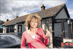
Jane Archer, whose home is valued at just £1
A campaigner who has been told her house is worth less than a loaf of bread will today try to show the man in charge of the nation's sea defences the true human cost of the government's coastal policies. The bungalow Jane Archer and her partner bought as a happy family home 21 years ago is still 60m from the clifftop, but is now worth just £1.
Today when environment minister Phil Woolas makes a fact-finding visit to north Norfolk over erosion and flooding issues she will be among the people keen to show him the impact of the government policy of abandoning sea defences without any compensation.
"I will tell him he is destroying our lives," said 49-year-old Ms Archer. "Lots of money is spent by the authorities compensating and finding new habitats for rare birds whose homes are threatened by climate and coastal management changes - but what about people? Are they just going to let my house fall over the edge of a cliff, and leave us with nothing?"
Mr Woolas is visiting Norfolk following the concerns of hundreds of other people living near the coast and in low-lying Broads villages which are vulnerable to erosion, and a controversial Natural England option of allowing six villages and 25 sq m of countryside to flood in the future because it is too difficult and costly to defend. After seeing reef defences at Sea Palling he will attend a meeting with representatives from a range of communities, including Ms Archer, who is a founder member of the Coastal Concern Action Group formed in her home village of Happisburgh in a bid to fight government "managed retreat" policies and battle for a fair deal for those affected by it.
Also attending is North Norfolk MP Norman Lamb who said it should be a collective effort of society to pick up the bill for adjusting to climate change not people like Ms Archer who were "in the front line through a quirk of fate and having to bear all the cost themselves."
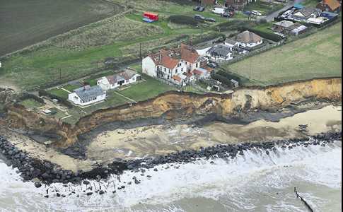
Jane Archer's bungalow is at the top right of the picture
He was encouraged that environment officials seemed more open to discuss impacts on communities, but remained concerned that the Treasury restrictions could hamper funding, and that there was a need for urgency to help other people like Ms Archer. She and partner Chris Cutting bought their Beach Road bungalow for £20,000 in 1987, when it was 400m from the clifftop and there were no problems over a mortgage and survey.
But a road and several houses have been swallowed up by erosion in recent years, after the government refused to fund the replacement of aging sea defences, and promoted a policy of managed retreat, which abandons long-standing defences everywhere except the main resorts.
So when the couple tried to get a bank loan to expand their motor engineering business, seeking to use the house as security, the valuer's report highlighted "chronic coastal erosion", refused the loan and valued the bungalow at a paltry £1.
Mr Cutting said: "It is not as if the house was right on the edge of the cliff. But we are now left with a house that is worth nothing, and lost about £60,000 through the collapse of the business deal." The couple thought the house might be worth about £50,000-£60,000 when they applied for the loan nearly two years ago, when a nearby cottage sold for £89,000 and other three bedroomed rural homes were selling for up to £200,000. "We were angry and frustrated when we told it was worth £1," said Ms Archer. "We are stuck here. We are worse off than first time buyers, because we only have another 15 years of earning towards a mortgage before we retire, and we don't want to rent and pay out again for housing having already paid off our existing mortgage. It is so unfair, because when we came here the policy was to maintain the defences," said Ms Archer.
Action group co-ordinator Malcolm Kerby said tackling that unfairness was one of their key aims they would outline to Mr Woolas today. "Forget all the fancy technical talk. This is the real effect of these policies on families. The government suggests people should move away from coastal areas because of climate change, but how can they if their home values are being hit. "They cannot pursue these policies without ensuring there is social justice. People like Jane and Chris are being put in a ridiculous position." He suggested that properties affected by flood and erosion risk should be underwritten by the government so areas were not blighted, leaving properties and communities viable. Adding the real value of buildings into the equation might also mean it became a cheaper option to protect rather than abandon.
National Audit Office takes up MARINET complaint
Two items, one from The Guardian of 2nd June and a similar from the Eastern Daily Press of 4th June, tells that the NAO are investigating MARINET's request on the huge cost of continuing offshore aggregate dredging and of the proposal from Natural England to abandon 25 square miles of Norfolk and six Broads villages to the sea as a result.
Watchdog called in over price of seabed dredging - Guardian 2nd June '08
Allegations that dredging shingle from the North Sea to replenish Britain's coastal defences is a waste of government money and counter-productive, are being studied by the National Audit Office. The body, which normally focuses on effective use of national finances, has been asked to look at the effect of extracting gravel and sand from the seabed and to see whether it is causing widespread coastal erosion in East Anglia and Yorkshire.
The washing away of beaches and undermining of clifftop homes has been associated with rising sea levels and global warming, but some marine scientists and local communities suspect that offshore dredging has a far more significant impact. "Global warming has been estimated to increase sea levels by 3.2mm a year [at most] and East Anglia is tipping into the sea, due to movement of the tectonic plates, by about 2mm a year," said Pat Gowen, spokesman for Marinet, a marine ecology group. "The impact of industrial-scale aggregate dredging in the North Sea has been far greater. In places the sea floor has been deepened by as much as five metres."
These holes, he says, make the seabed steeper, suck in shingle, and weaken offshore sandbanks which otherwise would break up large waves. "The dredging ships use enormous vacuum cleaners. Not only do they destroy the seabed but they also smother marine life elsewhere."
The most intensive dredging has been off Great Yarmouth; near this area, claims Marinet, erosion is most severe. The Environment Agency, which buys dredged materials to shore up beaches, and the dredging industry, represented by the British Marine Aggregate Producers Association, dispute the claims. About 25m tonnes of coarse gravel and sand is extracted from the sea around England and Wales each year.
Gowen has asked the NAO to investigate whether this is a sensible use of public money.
A NAO spokeswoman said the agency was not carrying out a full investigation "at the moment", but confirmed it was "looking at the issue".
Alison Baptiste, policy manager at the Environment Agency, said the organisation was attempting to manage beaches in a sustainable way.
Watchdog to probe coastal dredging - The Eastern Daily Press of 4th June 2008
A government spending watchdog is to look into the effects of offshore dredging on the East Anglian coast. And a Norfolk MP says he will ask the National Audit Office, which oversees spending by government departments, to hold a full investigation into the issue.
Environmental pressure group Marinet, part of Friends of the Earth, has asked the office to investigate whether it is cost-effective to dredge sand and gravel for sea defences when the dredging itself may be contributing to erosion. It has also asked for an investigation into the costs of the proposal from Natural England to abandon 25 square miles of Norfolk and six Broads villages to the sea.
Marine dredging is a major source of government income, raising millions every year in licences because the land is part of the Crown Estate - and millions more in VAT when the aggregate is sold. About 25m tonnes of sand and gravel are taken from the sea bed around England and Wales each year. Dredging started off the coast of Yarmouth in 1973, and since then it has been the biggest offshore source of aggregates. The material is used mostly for buildings and roads, but some goes to repair sea defences and replace sand washed away from beaches.
North Norfolk MP Norman Lamb said last night: "I will contact the National Audit Office and support this request for an investigation. There is no doubt from the work I have done that dredging can cause an increased rate of erosion. It is not the full problem, but more research is needed."
Pat Gowen, of Norwich, Marinet's spokesman for dredging, said: "They dig out the sand and it gets put on the beaches, which the following year is washed back into the big hole that has been dug. It is like a burglar robbing your house, selling your goods back to you and then robbing your house the following year. We have been (to the National Audit Office) on the grounds that they are dredging offshore to get sand and shingle to put on the beaches to replace that which has been eroded. I have had an acknowledgement from them and they say they are pursuing it. It could take an awfully long time."
A spokesman for the office said: "We are looking into it and will respond to the letter that has been send to us. At the moment we have no plans to have a full investigation."
A spokesman for the British Marine Aggregate Producers' Association, which represents most of the companies involved in offshore dredging, said: "If there is any evidence that dredging contributes to coastal erosion it would be useful to be aware of. But all the scientific evidence we have seen is that marine aggregate dredging does not contribute to coastal erosion. Perhaps this will flush out any other pieces of evidence that may be out there once and for all?"
Government persists in aiding and abetting coastal erosion
From the Great Yarmouth Mercury of 11th June '08 comes this report that despite all the evidence of the huge loss involved (see 'Waves of Destruction' at http://www.marinet.org.uk/coastaldefences/wavesofdestruction.html ) far, far greater than the cost of maintaining sea defences, the government are rigidly sticking to their plan to abandon twenty-five square miles of Norfolk to the sea.
The only possible explanation is that the amount of sand and gravel produced by the erosion so permitted will provide a continuing supply of aggregate, and hence a far greater income to the dredging companies, The Crown Estate and by the VAT applied.
MP fails to get report withdrawn
An MP fighting plans to surrender thousands of acres of Norfolk to the sea has spoken of his anger and frustration after meeting senior executives from the government agency behind the proposals.
Norman Lamb, Liberal Democrat MP for North Norfolk, had written to Natural England formally asking it to withdraw its draft report setting out four options for dealing with the consequences of climate change in the northern Broads. The last of these was a proposal to abandon nine miles of sea defences between Eccles and Winterton, flooding an area stretching inland as far as Stalham and Potter Heigham, with the loss of 25sq miles of land, including at least six villages.
Mr Lamb asked Natural England to withdraw the report, claiming no proper analysis had been made of the cost of abandoning the area and that the issue of compensation had not been considered. He said people living in the area were already suffering the effects of planning blight, with house sales falling through and property prices falling, after details of the proposals were leaked.
Natural England's chief executive Dr Helen Phillips wrote back to Mr Lamb, saying: "I am not persuaded that withdrawing the report or the fourth option within the report would serve a useful purpose. When we issue the final report, we will stress the need for society to plan how it needs to adapt to the impacts of climate change. Publishing our report will, hopefully, inform this process."
Yesterday at Westminster Mr Lamb met Andrew Wood, executive director of Natural England, and Shaun Thomas, East of England regional director, who reiterated that Natural England would not withdraw the report.
After the meeting Mr Lamb said: "They now accept if you're going to look at some long-term option you have to look at the social implications. That is in itself an advance, but their approach contradicts that and it's not happening in tandem. Their reaction was they still intend to publish. I have made it clear I think it would be callous to publish in these circumstances. I accept they were doing their work, looking at the long-term predictions, but now they know the consequences of their work reaching the public domain, they can't stand idly by and let those communities suffer. I made it clear I was very angry and frustrated that they appear to be unwilling to consider either cost-benefit or the issue of social justice before we look at the environmental considerations. "I'm appalled by this situation. I think they have got a responsibility to these communities. I don't see that anything would be lost by withdrawing this now so that there can be a more rational debate with those communities protected."
MARINET submits written evidence to Parliament's Joint Committee on the Draft Marine Bill
A Joint Committee of the Houses of Parliament has been considering the legislative and policy proposals contained in the UK Government's Draft Marine Bill. The Joint Committee has invited written evidence and MARINET has responded, see here. In this evidence MARINET has explained to the Joint Committee the necessity for the Bill to contain a duty upon the Secretary of State to create an ecologically coherent network of Highly Protected Marine Reserves covering at least 30% of UK seas out to 200 nautical miles by 2015. In addition, MARINET has responded in writing to the written questions of the Joint Committee, see here. The membership of the Joint Committee can be seen here. MARINET has also submitted additional written evidence to the Joint Committee on the scientific basis for designating Highly Protected Marine Reserves, see here. MARINET also requested the right to present oral evidence to the Joint Committee, but this request was not responded to or acknowledged.
MARINET says Draft Marine Bill needs to be fundamentally changed
MARINET has made a submission to the UK Government under the public consultation procedure operated by Defra with respect to the draft Marine Bill, see a copy here.
MARINET believes that the current framework and proposals in the draft Bill will neither restore biodiversity nor rebuild fish stocks in our seas, and that what is required is the creation of a Ministry of the Sea with a duty placed on its Secretary of State to create an ecologically coherent network of highly protected marine reserves covering at least 30% of UK seas out to 200 nautical miles by 2015. MARINET's proposals are consistent with the recommendations of the Royal Commission on Environmental Pollution in its 25th Report, titled Turning The Tide, published 2004 and the requirements of the forthcoming EU Marine Strategy Framework Directive which can be seen on our website at www.marinet.org.uk/marinebill/euframeworkdirective.pdf
At the moment the UK Government is failing to take such an approach. Although the draft legislation will create a series of Marine Conservation Zones (MCZs), some of which may be highly protected, MARINET believes that these MCZs will lack ecological coherence and will be unable to address the fundamental task of managing the ecosystem of our seas as a whole. Unless we adopt this extensive ecosystem approach to management throughout UK seas out to 200 nautical miles, the UK Government will have failed in its duty to manage the seas with any real effectiveness, and the current collapse in fish stocks and marine biodiversity will continue. At the moment the UK Government is saying we cannot tackle fishery issues beyond 6 nautical miles without the consent of the EU and its Common Fisheries Policy. MARINET believes the UK Government is wrong in this assertion, and we believe that the UK and our Parliament has sovereign powers which can protect fish stocks provided such action is taken within the context of managing the marine ecosystem as a whole.
In MARINET's estimation we cannot afford to prevaricate. Fish stocks are at historically low levels and if we delay any longer we may find that within five to ten years we have effectively destroyed and lost our marine ecosystem in its current form. Therefore the forthcoming Marine Bill is an opportunity that must not be squandered. Unfortunately a refusal by the UK Government to grasp the issue is, in MARINET's opinion, precisely what is happening.
As a result MARINET has described the current draft Bill as being without a soul and lacking any real spine. The Bill makes no commitment in terms of policy, and proposes to create a Marine Management Organisation (a marine version of the Environment Agency) sometime around 2010, and then only in stages. Action now is imperative, and the Draft Marine Bill does not display this characteristic. Consequently, MARINET will be continuing with its current national campaign to secure a duty on the Secretary of State to create an extensive network of marine reserves throughout all UK seas, and MARINET will be seeking an amendment to the Bill to this effect when it comes before Parliament in the autumn.
Call for one-third of North Sea to be marine reserves
The World Wildlife Fund for Nature (WWF) has published a report which argues that at least one-third of the North Sea should be established as marine reserves in which all fishing is excluded in order to rebuild fish stocks. WWF argue that temporary closures pioneered by the EU so far have not worked, and WWF further argues that unless conservation measures target the whole marine ecosystem and allow the full range of habitats to become re-established then conservation efforts to rebuild fish stocks will fail. The proposed network of reserves includes sites close to the Dogger Bank, the North Norfolk Sandbanks and north of the Shetlands and these areas have been selected because they are nursery and spawning areas. WWF cite reserves established by Iceland as evidence that such an extensive network of reserves can work.
The report is titled A Return to Abundance: A Case for Marine Reserves in the North Sea, and further details of the Report are available in a Daily Telegraph article.
UK Government acts to protect Lyme Bay sea life
Ministers at Defra have announced that they are to enforce a ban on damaging types of fishing in 60 square nautical miles of sea in Lyme Bay, Dorset. After public consultation and a full assessment of the impacts, the Government has ordered that the area be closed from early July. About ten per cent of Lyme Bay from West Bay to Beer Head will be permanently closed to scallop dredgers and bottom trawlers which drag nets along the seabed in order to safeguard the area's rich marine life and habitats. Fishing using nets nearer the surface or static nets and lines will still be allowed, as will diving for scallops, scuba diving and sea angling. Lyme Bay is home to world-renowned reefs as well as important species including pink sea fans, sunset cup corals and several rare sponges.
Hilary Benn MP, Environment Secretary, said: "Lyme Bay is one of Britain's richest marine environments, and the measures we have announced will protect the reefs and the wildlife that depends on them from the most damaging fishing methods. The environmental benefits will be huge, and species under threat will be able to recover and thrive."
Jonathan Shaw MP, Marine and Fisheries Minister, said: "A lot of work has gone into assessing the impacts, and this is just the kind of major decision about managing and protecting our seas that the Government's Marine Bill will help us take in future. The decision to protect Lyme Bay's wildlife shows that we are committed to protecting the marine environment. I want to work with people all around our coast to establish a national network of marine conservation zones to help protect the richness and diversity of life in our seas."
Dr Jean-Luc Solandt of the Marine Conservation Society said: 'In the end, most fishermen and conservationists want the same thing - sustainable fishing which has limited impact on the marine environment. The only way achieve this is to manage areas of sea appropriate to the vulnerability of the habitat, and to leave some areas completely alone to entirely recover from man's impact.'
James Portus, secretary of the South West Inshore Fishermen's Association, said: "I'm very disappointed to put it mildly. Dozens of people's livelihoods along the south coast are being sacrificed on the altar of the marine environment which we were perfectly capable of protecting through our agreement. We don't ban all the cars from the road just because one or two break the speed limit. We were even prepared to legislate to enforce our agreement. As it is, they haven't just closed the reefs, which are a much smaller area, they have closed a vast area. They have used a sledgehammer to crack a nut. It is not the way government ought to work, it should pay attention to the economic and social costs as well as to the marine environment. There has got to be a better way of managing the sea than this."
For further details see Defra News release and Daily Telegraph article.
Sea salt worsens coastal air pollution
A new scientific study published in the journal Nature Geoscience by a team of researchers that included University of Calgary chemistry professor Hans Osthoff, reports that industrial and shipping pollution is made worse when it combines with sunshine and salty sea air, see www.sciencedaily.com/releases/2008/04/080408163231.htm.
The link between sunshine and air pollution to create ozone (a lung irritant) at ground level is already well known, but this recent study suggests that the presence of chlorides (sea salt = sodium chloride) intensifies the formation of ozone, meaning that ports and coastal areas close to shipping lanes are likely to be seriously affected. Research into this phenomenon and related chemical processes is continuing.
New organisation to study impact of offshore windfarms
COWRIE (Collaborative Offshore Wind Research Into the Environment) is a registered charity set up to advance and improve understanding and knowledge of the potential environmental impacts and benefits of offshore windfarm development in UK waters. COWRIE Ltd has commissioned and published a number of reports on birds, marine mammals, underwater noise, cumulative impacts and electromagnetic fields in relation to offshore windfarms. These can be found on the new COWRIE website at www.offshorewind.co.uk under publications.
Mining of seabed minerals advanced by UK company
A UK company, Soil Machine Dynamics, has been awarded a £33 million contract to supply deep sea mining equipment. The object of this equipment is to extract metals (gold, silver, zinc and copper) from mineral deposits on the sea floor at depths of over a mile. These deposits have been formed by the seepage of acidic water through deep cracks in the sea floor where the mineral solution is precipitated into deposits which are high in mineral content. The mining equipment involves cutting-heads similar to those used in coal mining, along with powerful suction machinery to pump the pulverised mineral solution to ships at the surface. Recent rises in commodity prices now make this technology financially viable. For example, the current market value of copper is $3.80 per pound, and the cost of this extraction method is around $1.50 per pound. A great variety of marine species are found in these deep ocean ecosystems, many of which are poorly recorded and understood. Mining therefore could create enormous damage, and many of the ecosystems on the seafloor are very sensitive to damage and lack resilience in the face of disturbance. Like trawling, which has ravaged shallow seafloor ecosystems, mining could now pose the same threat to deep seafloor ecosystems.
Source: Bridge Marine Science Group, Anglesey
Decline in UK Bathing Water Quality in 2007
Using figures published by the Environment Agency, the Marine Conservation Society has published its Good Beach Guide which records the results for UK compliance for 2007 against the quality standards of the EU Bathing Water Directive.
The Good Beach Guide reports that the number of UK beaches failing the mandatory EU standard rose from 17 in 2006 to 53 in 2007. In their Press Release the Marine Conservation Society "blames this drop in water quality largely on an increase in storm related pollution caused by the wet weather."
Note: MARINET observes that the excuse of wet weather is a poor one. Water companies are meant to supplement their sewage treatment works with storm tanks. These tanks store sewage in wet weather and thus enable the sewage to be treated when the wet weather has abated. However it would appear that many water companies are not installing the required storm tank capacity, and thus discharging untreated sewage to sea when wet weather occurs. At the moment, non-compliance of a bathing water with the EU Directive under these circumstance must be recorded as a "fail" in the official statistics, but under a reform of the Bathing Water Directive soon to be introduced the water companies will be allowed to claim these events as "exceptional", and then be able to erase the "fail" reading from the official figures. Thus although UK consumers are paying record annual water charges, the revenue is not yet being invested in adequate storm treatment facilities and, when the reform of the EU Bathing Water Directive comes into operation, this failure will be lost from sight in the official Bathing Water compliance figures.
Bathing Water Quality in Europe 'officially fell slightly' in 2007
The EU Commission has published results for bathing water quality at coastal and inland resorts throughout Europe during 2007 (Note: This file is 12.53 MB).
Whilst it is claimed by the EU Environment Commissioner, Stavros Dimas, that standards have remained high, there was a fall in mandatory compliance for EU coastal resorts from 96% in 2006 to 95% in 2007, and a fall in guidleine compliance from 88% in 2006 to 86% in 2007. Mr Dimas also observed in a Press Release that "he was encouraged by a 44 per cent drop from 2006 in the number of bathing areas removed by member states from their national lists. This practice, known as "de-listing", is often done in order to avoid addressing pollution at source, he added, and could explain the fall in apparent EU bathing water quality last year".
Note: MARINET observes that the testing used in the calculation of mandatory compliance fails to include, in most cases, a check for salmonella and entero-viruses, despite this requirement being stated in the Directive itself. Therefore MARINET believes that the claim by the EU Commissioner of 95% mandatory compliance is unfounded and, if checks were carried out for salmonella and entero-viruses, mandatory compliance could be considerably lower. This failure to properly implement the Bathing Water Directive has been drawn to the attention of the EU Commission by MARINET, but the EU Commission has chosen to ignore it.
New Aggregate Dredging Licence issued off Humber Estuary
Hanson Marine has obtained a new licence to extract 500,000 tonnes per annum of sand and gravel for 15 years from Area 480 (also known as Area 106 East) located 25 miles south east of the mouth of the Humber estuary. The Joint Nature Conservation Committee (JNCC) originally expressed concern during the EIA procedure that dredging might harm the potential for Sabellaria spinulosa reefs (an Annex I habitat under the EU Habitats Directive) within the eastern arm of the site, and the licence has only been issued on the understanding that there will be no dredging in the eastern arm without further consultation and a review of the data collected from pre-dredge surveys. Area 480 is a fraction under 10 square kilometres in size.
Severn Barrage is poor value for money
A Report written by Frontier Economics, and commissioned by 10 environmental organisations which include the RSPB, National Trust and The Wildfowl and Wetlands Trust, has concluded that the proposed Severn Barrage from Lavernock Point, in the Vale of Glamorgan, to Brean Down in Somerset will cost £15 billion and represents poor value for money if that same sum were to be spent on other forms of generating renewable energy. In addition, the report questions whether sufficient compensatory habitat can be found to replace the European SAC and SPA habitat that would be lost should the barrage be built. Hence the Frontier Economics report concludes that the proposed barrage "can't be justified". The Westminster Government will decide in September of this year whether to commission further studies into the viability of the proposed barrage.
Source: Western Mail, 12th June 2008
New Marine Aggregate Dredging Licence in Bristol Channel
The marine aggregate companies, Hanson Marine and Cemex UK Marine, have obtained a new licence to extract up to 1.5 million tonnes over 10 years from Area 472, Culver Sands, which lies on the median line separating England and Wales, approximately 8 miles south of Barry and 8 miles north of Minehead.
Culver Sands is a sand bank completely covered by seawater at all times at a depth no greater than 20 metres, which means that it fits the descriptive criteria of the Annex I habitat listed in the EU Habitats Directive. However Culver Sands has never been forwarded by the UK Government to Brussels for listing under the Habitats Directive, and therefore does not currently enjoy such legal protection. During the EIA procedure in the licencing application, this potential Annex I status was drawn to the attention of the UK Government. However the applicant advised the UK Government and its conservation agencies that it only wished to excavate a section of Culver Sand that is separated from the main sandbank, and the applicant's consultants advised the UK Government that there is no interchange of sand between this small separate sandbank and the main sandbank, and therefore the main sandbank's integrity would remain unaffected by aggregate dredging.
Note: MARINET has objected to the granting of this licence, and has argued that there is no real evidence to substantiate the belief that there is no exchange of sand between the small and main sandbanks.
For further details, see www.marinet.org.uk/mad/objection.html#472
New Marine Aggregate Dredging licence for Liverpool Bay
Westminster Gravels Ltd has been awarded a licence to extract 18 million tonnes of coarse sand over 15 years, at a rate of 1.2 million tonnes per annum, from the seabed of Area 457 in Liverpool Bay. The site is located approximately 16 miles from the West Lancashire (Sefton) coast and 18 miles from the North Wales coast. The West Lancashire/Merseyside coast from the Ribble estuary to the Mersey estuary is all protected under the EU Habitats Directive, either for its importance to wild birds or for its extensive sand dune system and the biodiversity which this sand dune system supports.
Note: MARINET has objected to this licence application since it was first submitted in 2002, and has now requested the licencing agency (Marine and Fisheries Agency) to revoke this new licence and call it in for examination by a Planning Inspector under new procedures announced in the recent revision of Marine Minerals Guidance Note 2.
For further details see www.marinet.org.uk/mad/objection.html#457
Anger after Norfolk flooding meeting
From the EDP 11th June '08
An MP fighting plans to surrender thousands of acres of Norfolk to the sea has spoken of his anger and frustration after yesterday meeting senior executives from the government agency behind the proposals.
Norman Lamb, Liberal Democrat MP for North Norfolk, had written to Natural England formally asking it to withdraw its draft report setting out four options for dealing with the consequences of climate change in the northern Broads. The last of these was a proposal to abandon nine miles of sea defences between Eccles and Winterton, flooding an area stretching inland as far as Stalham and Potter Heigham, with the loss of 25sq miles of land, including at least six villages.
Mr Lamb asked Natural England to withdraw the report, claiming no proper analysis had been made of the cost of abandoning the area and that the issue of compensation had not been considered. He said people living in the area were already suffering the effects of planning blight, with house sales falling through and property prices falling, after details of the proposals were leaked.
Natural England's chief executive Dr Helen Phillips wrote back to Mr Lamb, saying: "I am not persuaded that withdrawing the report or the fourth option within the report would serve a useful purpose. When we issue the final report, we will stress the need for society to plan how it needs to adapt to the impacts of climate change. Publishing our report will, hopefully, inform this process."
Yesterday at Westminster Mr Lamb met Andrew Wood, executive director of Natural England, and Shaun Thomas, East of England regional director, who reiterated that Natural England would not withdraw the report.
After the meeting Mr Lamb said: "They now accept if you're going to look at some long-term option you have to look at the social implications. That is in itself an advance, but their approach contradicts that and it's not happening in tandem. Their reaction was they still intend to publish. I have made it clear I think it would be callous to publish in these circumstances. I accept they were doing their work, looking at the long-term predictions, but now they know the consequences of their work reaching the public domain, they can't stand idly by and let those communities suffer. I made it clear I was very angry and frustrated that they appear to be unwilling to consider either cost-benefit or the issue of social justice before we look at the environmental considerations. I'm appalled by this situation. I think they have got a responsibility to these communities. I don't see that anything would be lost by withdrawing this now so that there can be a more rational debate with those communities protected."
Community of Arran Seabed Trust wins Marine Reserve Award
C.O.A.S.T. (Community of Arran Seabed Trust) which is trying to create Scotland's first "no-take" marine reserve in Lamlash Bay has won The Observer newspaper's Conservation Project Award.
In the citation for making the Award, the judges said "In a closely fought contest and a strong category, the judges eventually selected this community-based project on the Isle of Arran that aims to protect the unique biodiversity of Lamlash Bay on the Arran Coast and to give its productivity a chance to recover for future generations. As celebratory-panellist Deborah Meaden put it: 'It was wonderful to see a local community say: "We're going to do this." After all, it's easy to gain support for a fluffy animal, but nobody cuddles fish.' Quite. Fourteen years ago the residents and supporters of Lamlash Bay began to fret about the destruction beneath the choppy waters but found that there was little to no legal protection for ocean biodiversity. They worked with fishermen, politicians and wider communities, and their painstaking mediation and education initiatives led this year to the UK's first No Take Zone around the bay - an exclusion zone of 267 hectares, providing protection from any fishing by anybody. Nothing will be removed, giving all marine life in the area - including rare maerl seaweed - a chance to regenerate. This award is for Coast's staying power and complete dedication."
For further details about the Community of Arran Seabed Trust, see www.arrancoast.co.uk
Major clean-up of tidal River Ribble planned
United Utilities, following pressure from the Environment Agency, has announced that it is to spend £95 million between now and 2011 on new sewers and treatment facilities along both banks of the Ribble estuary in order to eliminate storm discharges of untreated sewage. These discharges currently pollute the estuary and, in particular, sea bathing waters at Lytham St. Annes and other bathing sites along the Fylde and Sefton coasts.
Source: Lancashire Evening Post 2nd June 2008
Watchdog to probe coastal dredging
From the Eastern Daily Press of the 4th June '08
A government spending watchdog is to look into the effects of offshore dredging on the East Anglian coast. And a Norfolk MP says he will ask the National Audit Office, which oversees spending by government departments, to hold a full investigation into the issue.
Environmental pressure group Marinet, part of Friends of the Earth, has asked the office to investigate whether it is cost-effective to dredge sand and gravel for sea defences when the dredging itself may be contributing to erosion. It has also asked for an investigation into the costs of the proposal from Natural England to abandon 25 square miles of Norfolk and six Broads villages to the sea.
Marine dredging is a major source of government income, raising millions every year in licences because the land is part of the Crown Estate - and millions more in VAT when the aggregate is sold.
About 25m tonnes of sand and gravel are taken from the sea bed around England and Wales each year. Dredging started off the coast of Yarmouth in 1973, and since then it has been the biggest offshore source of aggregates. The material is used mostly for buildings and roads, but some goes to repair sea defences and replace sand washed away from beaches.
North Norfolk MP Norman Lamb said last night: "I will contact the National Audit Office and support this request for an investigation. There is no doubt from the work I have done that dredging can cause an increased rate of erosion. It is not the full problem, but more research is needed."
Pat Gowen, of Norwich, Marinet's spokesman for dredging, said: "They dig out the sand and it gets put on the beaches, which the following year is washed back into the big hole that has been dug. It is like a burglar robbing your house, selling your goods back to you and then robbing your house the following year. We have been (to the National Audit Office) on the grounds that they are dredging offshore to get sand and shingle to put on the beaches to replace that which has been eroded. I have had an acknowledgement from them and they say they are pursuing it. It could take an awfully long time."
A spokesman for the office said: "We are looking into it and will respond to the letter that has been send to us. At the moment we have no plans to have a full investigation."
A spokesman for the British Marine Aggregate Producers' Association, which represents most of the companies involved in offshore dredging, said: "If there is any evidence that dredging contributes to coastal erosion it would be useful to be aware of. But all the scientific evidence we have seen is that marine aggregate dredging does not contribute to coastal erosion. Perhaps this will flush out any other pieces of evidence that may be out there once and for all?"
EU Marine Framework Directive approved
On 14th May 2008 a meeting of the EU finance ministers gave formal approval to the EU Marine Framework Directive based on an agreement made with the European Parliament in December 2007. The Directive will now be published in the EU's official journal (the text can be viewed here on the MARINET website) The law requires member states to prepare marine strategies for the sea under their jurisdiction, and for these strategies to plan for and establish "good environmental status". These plans must exist by 2015, and be achieved by 2020.
Note: The MARINET UK Marine Reserves campaign is seeking a duty upon the Secretary of State to establish in the forthcoming UK Marine Bill (October 2008) an ecologically coherent network of Highly Protected Marine Reserves covering at least 30% of UK seas out 200 nautical miles (the boundary of the UK Exclusive Economic Zone) by 2015. The purpose of this network of highly protected marine reserves will be to protect the marine ecosystem as a whole, and thus deliver the EU Framework's obligation of "good environmental status" throughout UK seas - (The MARINET Briefing on Marine Reserves for Members of Parliament can be viewed here).
Mersey Tidal Barrage under active consideration
Peel Holdings Ltd and the North West Regional Development Agency are in partnership to consider whether a Mersey Barrage, last studied as an energy project in 1993, is a viable option. These partners are encouraged by the views of the Government's independent adviser, the Sustainable Development Commission ( www.sd-commission.org.uk ), which reported last year on the question of tidal barrages at various locations in the UK.
The tidal range of the Mersey estuary is considerable, ranging between 8 to 10 metres, thus giving real potential in energy terms for a barrage. If located in the estuary's "narrows" a tidal barrage could generate around 700MW, enough electricity to power one-quarter of a million homes. The world's first electricity generating tidal barrage was built in 1966 at La Rance in Brittany, France. The La Rance estuary has a similar tidal range (over 8 metres) to the Mersey, and the tidal barrage at La Rance generates 240MW.
One of the major problem with tidal barrages is the silting-up of the estuary behind the barrage. This reduces the electricity generating capacity of the barrage. In addition, the impounded waters behind the barrage can trap pollution and also cover salt marshes which were once exposed at low tide. Such salt marshes are important feeding grounds for birds. In the case of the Mersey, the estuary contains a European Special Protection Area for Birds (SPA under the EU Habitats Directive) covering 6500 acres. If Peel Holdings and the North West RDA go ahead with the Mersey Barrage proposal, they intend to submit a planning application in 2010, with construction to be completed by 2020.
A major technological feature of their design is a modern version of the waterwheel. For more details, visit www.merseytidalpower.co.uk
Legal Route for Coastal Erosion Victims
Dr. Harry Buckland proposes a path that could be tested by those threatened by coastal erosion aided and abetted by the Shoreline Management Plan and the government decision to fail to protect by defences. He writes:
"Marinet members will have read in the national press of an application for permission for judicial review of the Government's manifesto promise of a referendum on the European Constitution and subsequent refusal on the dubious grounds that the Treaty is a different animal.
"There is a legal concept of Legitimate Expectation ( otherwise know by the wonderfully archaic name of a 'promissory estopel') whereby, by word or deed, an expectation can be created. It seems to me that just such an expectation has for many years been created, fostered and funded by the Environment Agency and Local Authorities in respect of the maintenance of sea defences. How else could the Broads Authority have functioned without just such an expectation? Similar expectations were aroused in property owners and businesses from the Humber to the Hamble. It really is time to test this issue".
Delight at MPs' fight to save coast
From the Yarmouth Mercury of 8th May 2008
Coastal erosion campaigners have hailed the efforts of a cross-party group of Norfolk MPs as "a whole chunk of England standing together saying we cannot let Norfolk go."
Jim Bratton of Scratby's coastal erosion group said Great Yarmouth MP Tony Wright had put the case for his stretch of coastline well at a commons debate broadcast live on Tuesday. Mr Wright was one of a group of MPs who pledged to fight on after failing to win reassurances or concessions from the government over the mooted surrendering of 25 square miles of the county to the sea.
Environment minister Phil Woolas promised to visit the threatened area between Eccles and Winterton, but he glossed over an invitation by MP Norman Lamb officially to remove the highly controversial "worst case" sea defences option put forward by Natural England. And he stressed in the Commons that "it is not the government's policy to give compensation for the impact of floods and coastal erosion".
Although Mr Bratton was disappointed by Mr Woolas's "unsympathetic" response he was heartened by the debate which took local concerns to the highest level, adding "Mr Woolas can now be in no doubt about the widespread strength of feeling gathering pace." He said: "Tony put his point across very well about the flooding in Great Yarmouth and the erosion at Scratby. Afterall he has a coastline to worry about too although the emphasis has been on the whole of Norfolk. It was an opportunity for our area to be highlighted as well. With all but one of the Norfolk MPs saying the same thing it has to be a step forward because everyone is together. "It's a whole chunk of England standing together all speaking up and saying the same thing - we cannot let Norfolk go."
Mr Woolas added that there was an obligation to answer the question of whether compensation should be provided "if damage has been caused by climate change rather than the natural processes of erosion or flooding". But he did not answer it himself.
Figures released to the Countryside Alliance under the Freedom of Information Act have revealed that at least 14,434 new homes in the East are planned for construction on flood plains or in flood risk areas. Forty local authorities in the East responded to the Freedom of Information request. A total of 293,542 new homes are planned of which 14,434 are in flood risk areas. The research followed the Government's admission, last year, that it "does not collect centrally the number of houses planned for construction on flood plains".
A spokesman said: "Climate change and the increasing frequency of major flooding have led the Government to address the risk of flooding for new development through the planning process. This does not, however, address the legacy of development proposed before the new policy. The Government needs to carry out a full audit of housing proposed for flood risk areas. The alternative is a time-bomb of thousands of un-insurable homes in the East under constant risk of flooding."
MPs join in endeavour to stop coastal erosion and losses
The 6th May Eastern Daily Press carried the following article by Political Editor Chris Fisher.
MPs to fight on over flood plans
Norfolk MPs pledged to fight on yesterday after failing to win reassurances or concessions from the government over the mooted surrendering of 25 square miles of the county to the sea.
Environment minister Phil Woolas promised to visit the threatened area between Eccles and Winterton. But he glossed over an invitation by constituency MP Norman Lamb officially to remove the highly controversial "worst case" sea defences option put forward by Natural England.
And he stressed in the Commons that "it is not the government's policy to give compensation for the impact of floods and coastal erosion".
Mr Woolas added that there was an obligation to answer the question of whether compensation should be provided "if damage has been caused by climate change rather than the natural processes of erosion or flooding". But he did not answer it himself.
After the debate, Mr Lamb said the minister had not given the assurance that the affected communities needed and emphasised that "we will not give up until we get it". He was particularly concerned that Mr Woolas had not addressed the plight of people whose property values were immediately blighted by the leaking of the Natural England idea.
Norfolk Tory MPs joined in voicing disappointment after the 90-minute debate ended fractiously amid charges by Mr Woolas that "misunderstandings and myths have been perpetuated" and that he had been subjected to unfair party political criticism. Mid Norfolk MP Keith Simpson asked Mr Woolas to write to him with responses to the raft of questions that had not been answered in the debate.
Earlier, Mr Simpson had emphasised in the debate - which he initiated - that the people of Norfolk were demanding that the government "holds the line". They did not want a policy of "managed retreat". In endorsing that attitude, he said that retreat always ended in surrender unless there was a counter-attack.
Mr Simpson regretted that a pessimistic attitude seemed to be taking hold in Whitehall. He cited the example of Baroness Young, outgoing chief executive of the Environment Agency, telling a climate change seminar: "I think the Norfolk Broads will go. They will definitely salinate."
The MP said: "She has already mentally decided that the game is up. I do not think that any of us - certainly those of us here who represent Norfolk constituencies - wish to do that."
Mr Simpson told Mr Woolas that flood defences must be a national priority. And he urged the government to set out a clear and costed strategic plan and to involve local communities.
Mr Lamb said it was a basic duty of government to protect people and communities. The people of Norfolk were in the front line of the climate change threat, he warned. The North Norfolk MP argued that the option of surrendering part of the county to the waves must be withdrawn. And he said that what might be "a theoretical exercise" for Natural England was having an immediate effect by stopping people from selling their homes.
"Even though we are talking about a post-50 year period, if no financial security is in place now - no compensation scheme, or whatever one wants to call it - even discussing options for some future date can have an immediate blighting effect. That must be addressed. I know that he (the minister) understands the importance of social justice," he said.
Mr Woolas said the government had not changed its policy towards sea or fluvial defences. "The report by Natural England considered the potential impacts of climate change, including on the natural environment, based on different possible options in a post-50 year scenario," he said. "The government is committed to our existing policy to protect Norfolk as best we can for the next 50 years. The shoreline management plan is subject to discussion with the local authorities in the area. Although it is in draft form at the moment, it is public and transparent and it commits to defence for 50 years. By April next year, although I intend to publish it before that, it will lay out proposals for the post-50 year scenario."
Proposed solution to coastal erosion compensation issue
David Nowell, a correspondent to The Guardian on 21st April 2008 and a Fellow of the Geological Society, has proposed that land likely to be eroded by the sea within 100 years should only be available leasehold and that, if erosion occurred earlier than anticipated, then the leaseholder could claim compensation from a national "solidarity fund" used to compensate people against the consequences of natural disasters. This proposal would solve the issue of freehold owners of land losing all their capital asset when unforseen environmental conditions, such as accelerated coastal erosion, occur.
Correspondence with Government Minister about "managed retreat" in Norfolk
Mike King who lives in Scratby, Great Yarmouth, has asked Phil Woolas MP who is Minister for the Environment to explain the proposal in Natural England's recent report to allow a vast area of Norfolk (6,500 hectares) to be flooded by the sea. Read the letters between Mike, Phil Woolas MP and Tony Wright MP.
Does proposed Marine Bill protect our seas and coastal waters from unsustainable fishing?
The Independent 4th April '08 newspaper comments on the proposed Marine Bill, and wonders whether the provisions for protecting marine life and its biodiversity in coastal and inshore waters will be strong enough to resist unsustainable fishing practices, and also questions whether the Bill will seriously address the unsustainable fishing practices allowed by the EU Common Fisheries Policy in our offshore seas.
UK Government publishes draft Marine Bill
The Government has published its draft Marine Bill (www.defra.gov.uk/marine/legislation), to be introduced into Parliament in the Queen's Speech in October 2008. This Bill proposes to create a new planning and licensing system for the sea, to establish a Marine Management Organisation to fulfil these functions, and to enlarge on the provisions for nature conservation.
MARINET welcomes the new planning and licensing proposals in the draft Bill, but believes the nature conservation proposals are a long way short of what is required. MARINET believes that at least 30% of UK seas out to 200 nautical miles should be set aside as "no-take" Highly Protected Marine Reserves in line with the recommendation of the Royal Commission on Environmental Pollution.
MARINET believes than an extensive, ecologically coherent network of "no-take" marine reserves is absolutely essential in order to protect and restore the biodiversity of our seas, and that if the Marine Bill does not place a duty on the Secretary of State to create this network of "no-take" marine reserves then not only will our the ecological health and commercial value of our seas continue in its serious decline, but we will also have missed a major parliamentary opportunity to halt and correct this decline. Such law-making opportunities are rare, and therefore MARINET is urging members of the public to contact their Member of Parliament to request their MP to instruct the Government to ensure that the Marine Bill contains this duty upon the Secretary of State to create an extensive network of marine reserves, see www.marinet.org.uk/mreserves.html#briefing08march
Shell pulls out of London Array wind farm
The UK oil company, Shell has pulled out of the proposed offshore London Array wind farm in the Thames estuary. This wind farm with 341 turbines was scheduled to supply electricity to one-quarter of London's homes. Shell cite their reason for leaving the project as more profitable wind turbine opportunities in the United States. The British Wind Energy Association state that a new partner to replace Shell is now being sought.
For further details, see the Renewable Energy World website
A Pee in the Ocean?
Could this be a crafty way of disposing of human waste through sea outfalls, a methodology long opposed by MARINET, who are concerned about escalating plankton growth in the sea as well. To put it eloquently, are they 'extracting the urine'?
From 'Wired Science' under the categories of Climate, Environment, Government and Oceans comes this story by Brandon Keim. http://blog.wired.com/wiredscience/2007/11/carbon-offset-c.html
Absorbing CO2 by Dumping Urea Into Ocean Pisses Off Activists
The Philippines government has approved an Australian company's plan to absorb excess CO2 by dumping massive amounts of urea in the Sulu Sea. Environmental activists say the dumping is a potentially risky, scientifically unsound gamble that underscores the dangerous absence of international geoengineering regulations.
Like iron seeding, urea dumping is supposed to nourish blooms of greenhouse gas-gobbling plankton. But iron seeding is controversial, with some scientists saying it might produce even more CO2 -- and compared to urea dumping, iron seeding is well understood.
According to a statement issued by the Ottawa-based ETC Group, UK-based Corporate Watch, Malaysia-based Third World Network and the Philippines' SEARICE,
Urea and nitrogen fertilizer pollution caused by agricultural run-off has been linked to the creation of toxic algal blooms in the scientific literature, and raises the possibility of dead zones from oxygen depletion.
The groups called for regulators currently meeting to discuss the London Convention to evaluate urea dumping as well as iron seeding. The Convention, enacted by the International Maritime Organisation in 1972, prohibits oceanic waste dumping -- but while simply pouring urea into the sea would be illegal, doing so to absorb carbon dioxide is permitted, or at least not forbidden.
That regulatory loophole is symbolic of the general absence of international guidelines for large-scale climate modification projects, both at sea and on land; and Sulu Sea urea dumping, proposed by the Ocean Nourishment Corporation and planned in the future for Malaysia, Chile and the United Arab Emirates, is symbolic of projects that are only going to become more common as climate change and entrepreneurship collide.
'Jet Blade' Hydrokinetic Turbine
A new and innovative hydrokinetic turbine that operates with low velocity omni-directional flows has been invented and developed by George Tonchev of Sofia, Bulgaria. A full patent for this is pending.
Full details are to be found by visiting his website www.tonchev.org or going directly to: www.tonchev.org/videohydrokinetic.html
Tidal Barrage for The Wash angers Wildlife Groups
The Royal Society for the Protection of Birds and the Lincolnshire Wildlife Trust have reacted strongly to the suggestion from Dr Peter Dawe, a dotcom millionaire who started up Pipex the UK's first internet service provider, that The Wash should be dammed in order to provide electricity and coastal protection. The Wash is regarded by wildlife groups as one of the UK's premier sites for wild birds and coastal marine life. The local MP for North East Cambridgeshire, Malcolm Moss, is quoted as saying that the scheme has tremendous potential.
For full details see The Guardian, 29th April 2008
Are the dredgers getting worried?
Sand and Gravel News carried the following news article on April 11th '08, which suggests that the business is more than a little worried about the growing concern being expressed and the call for an investigation on marine aggregate dredging.
Councillor calls for probe into dredging on UK's east coast
Alarm about the accelerating rate of erosion along the East Coast of the UK has sparked calls for an investigation into the impact of dredging.
According to a report in The Yorkshire Post, residents have become increasingly concerned at the rate of erosion along areas such as the Holderness coast, and some believe it is directly linked to the increasing amount aggregates dredging in the North Sea.
Said The Yorkshire Post: "According to local reports, as much as 100ft of coastline disappeared in places along the Hollym/Holmpton coastline during Spring tides and gales last April and October, with other large losses reported elsewhere."
At a recent East Riding council meeting, Tory councillor Richard Stead asked the Tory-led authority - which, for the past decade, has adopted a controversial 'do nothing' policy along the coast outside settlements - to agree to write to the Government expressing people's concerns.
His motion asked if any research has taken place "and, if not, that an investigation is undertaken as a matter of urgency, as we witness the progressive disappearance of our coastline".
Waves of destruction
Rising seas are changing Britain's coast dramatically. Norfolk is the first low-lying area to face a stark and cruel new choice - plough millions into doomed defences, or abandon whole villages to the invading waters. This article appeared in the Guardian on Thursday April 17 2008 and can be read in full on the MARINET website here.
The Wash Barrage - Damage or Destruction?
The proposal to construct a barrage across The Wash has brought about a whole new debate over the apparent conflict of interests between those who wish to see protection of people and property as Global Warming escalates sea rise, and those who wish to maintain such an internationally important wetland site free from damage. To satisfy both concerns with such a scheme may not be impossible, but this depends greatly on any additional development that may be included once the area is 'managed' for profitable return of investment.
Read more details on the MARINET website here.
Croatia forced to dismantle a Marine Reserve by the European Union
Croatia created an Ecological and Fisheries Protection Zone on 1st January 2008 in order to preserve the fisheries in its seas, but it has been forced by the European Union to dismantle this Protection Zone (marine reserve) by the European Commission on the grounds that the reserve prevents its neighbours, Italy and Slovenia, from exercising their rights to fish in these waters. Croatia is not a member of the EU, but has been forced to take this action by the European Commission who informed Croatia that if it did not dismantle the marine reserve, and thus allow acess to Italian and Slovenian fishermen, Croatia's current application to join the EU would be rejected.
For the full story, see The Slovenian Times
Demands to save The Broads escalates
From the pages of the Eastern Daily Press 17th April come these further two articles showing the growing opposition to the sacrifice of the Norfolk Broads and its villages to the sea.
Broads surrender 'unacceptable'
The government must continue to fund coastal defence projects to prevent the "completely unacceptable" loss of 25 square miles of the Broads to the sea. That is the plea from the Broads Society which said it was "extremely concerned" to learn of proposals being considered by government conservation advisers Natural England that, if adopted, would lead to thousands of acres of land, hundreds of homes and some of Norfolk's top wildlife sites being surrendered to the sea.
The society, which has 1,600 members, said three of the four proposals outlined in a draft Natural England report would result in a large area becoming an "embayment" of the North Sea. It is against proposals to cease maintaining coastal and flood defences, allowing them to be breached by the River Thurne and the sea, and also opposes the controversial "option four" that would involve flooding an area stretching as far inland as Potter Heigham and Stalham. Even holding the line - maintaining existing defences in their present position, the current policy of the Environment Agency - would ultimately have the same effect since they would eventually be undercut by saltwater, it argues.
The society said it had "considerable reservations" about the remaining option - adapting the line by allowing some areas to flood while protecting others - arguing that this could be extremely costly and visually intrusive. Instead it is proposing a new, fifth option, calling on the government to provide the Environment Agency with the funding it needs to fulfil its commitment to continue feeding the beach in front of the sea wall between Eccles and Winterton with sand and shingle. It is also urging the Environment Agency to commission a wide- ranging study into ways in which the sea wall can be strengthened or protected to ensure it remains in a sustainable condition for much longer than currently foreseen.
Dr Martin George, a committee member and former chairman, said: "The area that would be lost under three of the four proposals is an integral part of the Broads - a region that has been afforded the status of a national park - and the society considers it completely unacceptable to allow part of it to become an open estuary." He said if any of these proposals were adopted, it would result in the loss of several hundred homes and thousands of acres of farmland at a time of growing worldwide food shortages. Five broads, plus important plant and animal life, would be lost.
Dr George added: "We believe that it could well prove less expensive to provide the sea wall which currently fronts this section of coast with additional protection against the scouring effects of the sea than to construct a completely new line of defences to the rear."
Second story from the Eastern Daily Press 17th April
Defence chief condemns Broads flood plan
Britain's top soldier - who has spent a professional lifetime defending the realm - last night joined the battle to save huge swathes of Norfolk from being surrendered to the sea. General Sir Richard Dannatt, who is a Norfolk farmer and president of the 2008 Royal Norfolk Show, said it would be a tragedy if plans to allow the sea to breach coastal defences between Horsey and Winterton, were allowed to go ahead. Speaking exclusively to the EDP, Sir Richard said he was shocked to hear that the area around Horsey - one of his favourite locations in the county - was at the heart of proposals to allow the sea defences to be breached in a move that would see 25 sq miles of the Broads surrendered to the sea.
Sir Richard, who as Chief of the General Staff is the professional head of the British Army, said: "I think it would be a tragedy if we allowed that area to be given up and inundated." The General, who pointed out that he spent his professional life "defending UK interests" and by definition, potentially protecting UK territory, added: "I think to give up a great chunk of Norfolk to the sea without a fight is something I find quite counter-intuitive and quite difficult to do. I really think we should continue to invest in the sea defences around there, I think it would be a tragedy to lose a wonderful area of the county by allowing the sea in without a fight. After all, the Dutch manage to achieve this perfectly well so why can't we do this on our side of the North Sea." Sir Richard, who farms just south of Norwich, joins a growing group of campaigners who are opposed to the proposal by Natural England.
The proposal is one of four being considered by Natural England, and would see low lying areas as far inland as Potter Heigham and Stalham - where new sea walls would be built - would be flooded. Hundreds of homes and thousands of acres of farmland and some of Norfolk's top wildlife sites would be lost beneath the waves. The villages of Eccles, Sea Palling, Waxham, Horsey, Hickling and Potter Heigham along with parts of Somerton would be given up to the sea. The area would be allowed to revert to reed beds and saltmarsh.
The other options under consideration are to "hold the line" of existing defences, do nothing and allow defences to fall into disrepair, and "adapt the line" by moving defences slightly inland.
However, the Environment Agency has said that its present commitment is to continue to maintain the defences of the Broads for at least the next 50 years. Steve Hayman from the Environment Agency has also indicated that a further £7million of work is scheduled to take place over the next two years to continue the protection of the coast.
Sir Richard has lived in Norfolk for the past 35 years and is passionate about the county, its landscape and the wildlife and conservation work that has been carried out in the areas affected by the proposal. He has been elected President of the Royal Norfolk Agricultural Association and will preside over the 2008 Royal Norfolk Show in June, which this year is expected to have a strong military theme to it.
Clarification of the proposal to abandon Norfolk's Sea Defences
To help to answer some of the many questions arising, The Eastern Daily Press of 16th April has made an effort to find out just how this amazing threat to abandon the sea defences has come about.
Surrendering to the sea: Q&A
Proposals to surrender 25 sq miles of the broads to the sea, in response to climate change, have provoked a public outcry since they were revealed by the EDP. But where have they come from, why are they being considered, and will they ever become a reality? Jon Welch looks for some answers.
What are these proposals?
- To allow the sea to breach coastal defences between Horsey and Winterton, flooding low-lying areas as far inland as Potter Heigham and Stalham, where new sea walls would be built.
- Hundreds of homes, thousands of acres of farmland and some of Norfolk's top wildlife sites, including Hickling Broad and Horsey Mere, would be surrendered.
- The villages of Eccles, Sea Palling, Waxham, Horsey, Hickling and Potter Heigham, as well as parts of Somerton, would be lost to the sea, eventually reverting to reedbeds and saltmarsh to create a habitat for wildlife.
Where have they come from?
- A Broads climate change "workshop", organised by government conservation advisers Natural England, was held in Norwich in February.
- A draft document, since leaked to the EDP, outlined four options for dealing with the effects of climate change in the Upper Thurne area.
- Option one was to do nothing, allowing coastal defences and inland flood embankments to fall into disrepair, to be breached by the River Thurne and the sea. Option two was to "hold the line" and maintain existing defences in their current positions. Option three was to "adapt the line": move defences slightly inland. The fourth option, described as the "embayment of the Upper Thurne" is outlined above.
- A further four options were listed for the rest of the Broads: do nothing; hold the line; adapt the line, giving rivers more space; and build a barrier across the River Yare.
When would this happen?
- The document says that maintaining coastal defences in their existing position will become "increasingly difficult and expensive", adding: "The increasingly unsustainable nature of the Horsey to Winterton frontage beyond the next 20-50 years thus opens up the possibility of realigning the coast as described above within this time frame."
Are these proposals new?
- No. The proposals that make up option four were initially drawn up by English Nature and the Environment Agency in 2003, but that document envisaged this situation would not occur for at least 100 years.
- Now the suggestion is that it could be much sooner. Very similar proposals are contained within the Kelling to Lowestoft Ness Shoreline Management Plan, expected to be approved this summer by North Norfolk District Council.
Why is this being considered?
- Cost, primarily. Maintaining sea defences is an expensive business, not least because vulnerable beaches must be constantly "fed" with material.
- With East Anglia gradually sinking, and sea levels forecast to rise, there may come a point at which the government decides it is no longer economically viable to defend certain areas. Opponents say the cost is tiny compared to some areas of government spending.
- The leaked document also suggests that in selecting such a radical option "the right message about the scale and severity of the impacts of climate change is delivered to the public".
How has news of these proposals been received?
- The Broads Society is "horrified"; sailors, anglers and tourist bosses are concerned; and in the communities that would be affected there is fear and anger, much of it centring on concerns about property blight. Hundreds of people have attended public meetings in Hickling, Potter Heigham and Sea Palling, organised by North Norfolk MP Norman Lamb and coastal defence campaigner Malcolm Kerby. Nearly 1,000 people have signed a "Save the Broads" petition on the 10 Downing Street website.
Would this scheme ever see the light of day? Isn't it just pie in the sky?
- It might sound unthinkable, but all the indications are that government agencies are giving it serious consideration. The Environment Agency has reaffirmed its commitment to "hold the line" for the next 50 years, but chief executive Lady Young has said that after this, there are "difficult decisions to make". Environment secretary Hilary Benn said it could prove uneconomical to protect some places from rising sea levels, warning: "Nature is more powerful than all of us". Natural England's regional director Shaun Thomas said the proposals were only at an early draft stage, but added: "However, climate change will increase the pressure on sea defences, and we must start to look at how we manage the consequences of this."
- Norfolk County Council is against the proposals, and has said it will lobby government to continue to hold the line.
What about compensation?
- This hasn't been specifically discussed.
- Last year the government set aside £10m a year to "assist communities in adapting to change where constructing defences is not the most appropriate means of managing flood and coastal erosion risk". Eric Lindo, of the Stalham with Happing Partnership, estimates "option four" would involve the loss of farmland worth at least £25m, and housing worth at least £472m. But as UK law stands, the government has no duty to compensate people whose homes are lost to the sea.
What happens next?
- It's unclear. The Environment Agency, responsible for coastal defence, is committed - for the meantime, at least - to hold the line. Natural England, whose views carry a lot of weight with the government, has said that once it improves its draft document it will make the information public. It has formed a "high-level strategic climate change panel" with officials from the Broads Authority and Environment Agency, whose first meeting was held on Monday. Certainly there will be a lot more talking and lobbying, but a final decision could be years away.
Pressure mounts on the Government over threat to abandon Norfolk Sea Defences
From the Eastern Daily Press of 10th April comes this story by Jon Welch
'We need a debate' call
Horsey windpump - one of the many distinct features of the Broads which could be lost
The government agencies behind controversial proposals to abandon a large area of the Broads to the sea are being urged to break cover and explain their plans to the public. Campaigners have called on Natural England and the Environment Agency to come to Norfolk to meet the people who would lose their homes and livelihoods if proposals to surrender 25sq miles of Norfolk were implemented.
North Norfolk MP Norman Lamb and coastal defence campaigner Malcolm Kerby issued the challenge before addressing a public meeting on the issue in Potter Heigham, attended by 400 people. Mr Lamb said he had already met officials from Natural England, the government's conservation advisers, and the Environment Agency, which is responsible for coastal defences, but added: "I'm very clear that they must engage directly with the public. "It's absolutely essential that there should be a proper discussion. They must have the opportunity to explain all of their case and all the issues to the public. "It's important for people to understand what's happening with sea level rises and we must have an informed discussion about this. "Those agencies need to understand directly from the people concerned - the residents - that their position, and mine, is we hold the line and defend that coastline."
In a letter to the EDP, Natural England said the proposals had been contained in a draft report that would be made available to the public when it had been improved. However, a spokesman was unable to say when that might be. Mr Lamb has also written to environment secretary Hilary Benn asking him to visit Norfolk to meet local people and hear their concerns.
Mr Kerby, co-ordinator of the Happisburgh-based Coastal Concern Action Group, urged officials to come to Norfolk to meet the people. "They sit in ivory towers dreaming up some of the most outlandish schemes and ideas without any reference to the people who pay for the strategy and will suffer the consequences. Let them explain themselves," he said.
Last night's meeting at Potter Heigham village hall was the second of three organised by Mr Lamb and Mr Kerby. They said they had not asked Natural England officials to attend because, with feelings running high, they anticipated a hostile reception.
The controversial plan, which would involve the loss of at least six villages, thousands of acres of farmland and some of the county's top wildlife sites, is one of four options outlined for the Upper Thurne area in response to the threat of climate change. The proposals, first drawn up in 2003, resurfaced in a document discussed behind closed doors at a Natural England-organised conference in Norwich in February. They would involve allowing the sea to breach coastal defences between Horsey and Winterton, flooding low-lying areas as far inland as Potter Heigham and Stalham, where new sea walls would be built. The document suggests this action could be taken within the next 20 to 50 years. The other three options were to do nothing and let nature take its course; to hold the line and maintain existing defences; and to adapt the line by moving coastal defences slightly inland.
Last week Environment Agency chief executive Lady Young told the EDP: "We have committed to trying to 'hold the line' for the next 50 years, but after this there are difficult decisions to make."
Climate Change Impacts on our Seas and Coastline
In an article in The Telegraph of 14th April '08 Paul Ecclestone relates how Climate Change is effecting our seas.
Climate change will mean winners and losers around British coastline

Basking sharks on Britain's coastline may benefit from climate change
Some native species are already being threatened by rising sea levels, erosion and harsher, more frequent storms. But as some creatures retreat or disappear they will be replaced by opportunistic new arrivals, according to the National Trust.
The report says some birds which have traditionally nested by the sea's edge will have to move further inland to escape the stormier conditions. Other marine animals such as seals also face the loss of breeding grounds as the sea sweeps away shingle beaches and floods caves. Increased pounding by storm waves threatens fragile sites such as salt marsh, sand dunes, silt, reedbed and coastal wetland where wildlife often has only a perilous toehold.
The National Trust's Coastal Risk Assessment Officer, Adrian Woodhall, said: "Our research has shown that our coastline is seeing a huge amount of change. This is having, and will have, a major impact on the wildlife and habitats that stretch all the way around our coast - both marine and terrestrial. To try and predict what will happen over the next 100 years we have carried out risk assessments at all of our coastal sites to identify the areas most likely to see major change, what will happen at these sites in the future and what this will means in practical management terms. As a result of our research and the experience of staff we have found that many species of wildlife are facing an uncertain future due to coastal squeeze and erosion linked to climate change. But it's not all bad news, and we expect to see some new species reach these shores."
The Trust says conservation work will have to adapt to the new challenges climate change will bring as birds and other animals are forced to seek new habitats.
Dr David Bullock, Head of Nature Conservation at the National Trust, said: "In the future the focus of nature conservation will have to be on making space for wildlife to move around the wider landscape and not just within the current protected areas. At the National Trust we already work with our neighbours, but this will become even more essential as species need to mobilise to cope with climate change."
Potential winners on National Trust land include:
Basking sharks - Usually seen along the west coast of England, Ireland, Wales and Scotland they are now following the blooms of plankton they feed on. The plankton has moved because of warmer, cleaner waters.
Found in:
- Headlands along the Devon & Cornwall coast (especially in August)
- Lundy Island off the north Devon coast
- Farne Islands off the Northumberland coast
Glanville fritillary butterfly - Can be seen on National Trust land:
- Compton Chine at Freshwater on the Isle of Wight
Little egret - Once found close to the Mediterranean the egret has been steadily moving northwards across Europe and is feeling increasingly at home in Britain. Since the late 1980s it has been taking advantage of the warmer weather and moved northwards as the Humber estuary.
Can be seen on National Trust sites:
- Brownsea Island, Dorset
- Strangford Lough, County Down
Other possible winners:
Celtic Sea Slug - A Mediterranean species currently found in rock pools in Cornwall, warmer weather could mean they increase their range further.
Terrestrial alien plants, such as three cornered leek, Bermuda buttercup, hottentot fig. These species will spread inland, but could threaten many plants as they become dominant.
Three possible losers on National Trust land:
Terns - Internationally important breeding colonies of terns nest perilously close to the sea edge. With rising sea levels and increasing stormy weather, they are at risk of being lost as their breeding grounds becoming flooded.
Terns particularly at risk on National Trust land are:
- Sandwich terns at Cemlyn Estate on Anglesey in north Wales
- Little Terns at Blakeney on the North Norfolk coast
Grey seal - Uses isolated shingle beaches to hide pups born in the autumn. With sea-levels rising beaches will become narrower with rising sea levels putting baby seals at higher risk of being washed away.
The best National Trust sites to see this mammal are:
- Pembrokeshire in Wales
- Farne Islands in Northumberland
- Lundy Island in Devon
- Cubert in Cornwall
- Strangford Lough in Northern Ireland
Sandhill rustic moth - One of the four types of this moth is only found at a single-site in Cornwall. This site is a shingle bar blocking an inland freshwater pool from the sea. With increasing stormy weather and sea level rise the bar is being washed over more frequently. If conditions continue will be in danger of being totally washed away.
The only National Trust site to see the moth is:
- Loe Pool in Cornwall
Other possible losers:
Lagoon snail - Rare southern species, just a few mm in size, will suffer if caves are inundated with water for a long period of time. (Broadhaven South, Pembrokeshire).
Wading birds - The salt marsh and mud flats which they call home will become squeezed by rising sea levels, leaving them nowhere to go.
Norfolk County Council joins the battle
Despite the fact that MARINET has had this on its website for some three years now, the revelation by the media of the possibility of losing some of Norfolk's best farmland, countryside, villages, wildlife sites and The Broads came as a great shock to many. Now Norfolk County Council are taking up the cudgels to defend Norfolk from the hostile proposal. From the Eastern Daily Press of 7th April '08 comes the following article.
No surrender vow over sea defences
There will be no surrender in the fight against proposals that would abandon "vast acreage" of the Norfolk Broads to the sea. That was the pledge last night from Norfolk County Hall, which said it would battle to win government support and funding to "hold the line" of current coastal defences.
Communities have been left stunned since it emerged that Natural England, the government's conservation advisory body, is considering a proposal to let the sea engulf up to 25sq miles of Norfolk. The controversial proposal is one of four being considered by Natural England, and would allow the sea to breach coastal defences between Horsey and Winterton, flooding low lying areas as far inland as Potter Heigham and Stalham, where new defences would be built. If adopted, that would see the loss of hundreds of homes, thousands of acres of farmland and internationally important wildlife reserves including Hickling Broad and Horsey Mere. The three other options are to do nothing to hold back the sea, maintain the line of current sea defences, or move them slightly inland.
Last night Ian Monson, Norfolk County Council's cabinet member for the environment and waste, said the authority would press the case that the land is worth defending on social, economic and environmental grounds. Concern about the fate of the region's coastline has risen since details of the plans emerged in the EDP last month.
Ironically, further along the coast The Wash Tidal Barrier Corporation is bidding to build a new sea defence barrier between Hunstanton and Skegness in a move to protect people from the growing threat of storm surges engulfing the area. The firm, which is launching its bid for a self-financing barrier on April 28, said with sea levels rising by 2mm a year it is only a matter of time before the current defences are overwhelmed. And in north Suffolk volunteers are resorting to rebuilding flood barriers to stem a breach of the Blyth Estuary near Southwold after the Environment Agency said it would not fund long-term defences.
The EDP reported last week how environment secretary Hilary Benn warned that stark choices will need to be made about investment in the defence of coastlines, which could see some coastal areas surrendered to Mother Nature. Yet last night Ian Monson, Norfolk County Council's cabinet member for the environment and waste, said the authority had "absolutely no intention" of supporting a proposal to surrender large areas of land to the sea and would lobby government to hold the line of existing sea defences. "We feel we have got to support the people of Norfolk," he said. "We don't want to see the water coming in. Holding the line is basically what we support. Clearly there is a cost to that in the longer term, but what we are saying is that can all be determined in the future - the policy of holding the line is for the next 20, 30 and 50 years. We hope to be able to persuade future governments to realise that the social and economic of having that area flood, or any part of Britain, is far more important than they are actually giving credit for at the moment. Clearly it would be difficult to know where the money is coming from if we were facing a catastrophe tomorrow. But at the moment the defences are safe - that is the point. It's not something that's going to happen tomorrow. We can endlessly speculate about what might or might not be necessary in 30, 50 or 100 years time," Mr Monson added. "What is certain is that there will be no rush to abandon vast acreages of the Broads or the people who live there. These parts of Norfolk are as important to the county and its economy as they are to the wildlife and the natural environment."
Eric Lindo, chairman of the Stalham and Happing Partnership, which works to regenerate a large area of north-east Norfolk welcomed county hall's stance. "That's great news," he said. "Some sanity has been brought back to the situation on behalf of Norfolk people. It's the sheer shock and surprise that's taken everybody's breath away, and the unfeeling response from an environment secretary whose own ancestral home is protected by a sea wall. He said the government had frittered its funds on "eye-catching egotistical projects" such as the Millennium Dome, Olympic Games and the Eurofighter at the expense of protecting the country's own shoreline.
A trio of public meetings are to be held in the next fortnight to allow residents the chance to debate the issue.
Mr Lindo said the public needed to put pressure on all politicians of all levels to raise spending on flood defences. "The first step is the public meetings so that we can co-ordinate what's happening," he added. "We need to start making a nuisance of ourselves and it's up to us to tell our elected representatives what we want our money spent on."
MARINET member writes to Government Minister about "managed retreat" in Norfolk
Mike King who lives in Scratby, Great Yarmouth, has asked Phil Woolas MP who is Minister for the Environment to explain the proposal in Natural England's recent report to allow a vast area of Norfolk (6,500 hectares) from Eccles-on-sea to Winterton-on-sea, and as far inland as Stalham, to be flooded by the sea. His letter to the Minister asks how Natural England, an organisation that is supposed to care for our environment and the unique wildlife in the Norfolk area, can propose such destruction, and whether Natural England are they acting on their own initiative or are following Government guide lines?
The full text of Mike King's letter can be see on the MARINET website at www.marinet.org.uk/coastaldefences/mikekingwoolas.pdf
New Norfolk Rebellion?
A series of talks to ensure that those threatened with losing their property and living are now ongoing in Norfolk. Pat Gowen attended and spoke at the first meeting held in St. Mary's Church at Hickling, one of the villages that could be lost to the sea. It was a very angry debate with severe criticism directed at DEFRA and Natural England. Such was the language and expletives employed that the Vicar had to remind people that we were in a Church! The following story by Ed Foss comes from the Eastern Daily Press of 9th April '08.
'We will fight to save our villages'

Villagers vented their fury at the government during a packed public meeting held last night in one of the parish churches directly threatened by a proposal to abandon six Broads villages to the North Sea. Around 400 people packed into St Mary's Church in Hickling to decide how to react to possible plans revealed in the EDP at the end of last month which could see hundreds of homes, thousands of acres of farmland and some of the county's top wildlife sites surrendered to the sea.
Under the proposal - one of several which has so far only been considered behind closed doors by the agencies involved - 25 square miles of Norfolk could be flooded by a coastal breach and allowed to turn into salt marsh and reed beds. The villages concerned are Hickling, Horsey, Sea Palling, Waxham, Potter Heigham and Eccles.
At last night's meeting it was revealed for the first time that the plan would affect 600 homes, a figure obtained by North Norfolk MP Norman Lamb through direct discussions with the Environment Agency and Natural England, two of the key bodies involved. The meeting was the first of three and provided the first opportunity for the public to discuss and debate the deeply controversial plans. Concerns centred around property blight, the fact the proposals had so far only been discussed secretly and whether it would be possible to take the government to court.
The first person to speak was Peter Boggis, who has become well known for his fight to save his home from coastal erosion at Easton Bavents, near Southwold. "There is nothing more natural for a man to stand up and fight for his home and the way of life he enjoys," said Mr Boggis. "It is in the public and national interest that the coast should not be abandoned." Mr Boggis said the government agencies involved had failed to "respect property or human rights" and said they actions were "almost criminal".
Chris Hall, a Horsey parish councillor, said it was important to include the "whole of Norfolk" in any battle with the government over the issue, as it was something which concerned a much wider area than the six named villages.
Chris Hollis said he was "appalled" by Natural England's comments about habitat and failure to mention jobs, homes or history. "Are the Dutch giving up part of their country like this?" said Mr Hollis.
Hickling resident Simon Mann said he had considerable concerns about the "clandestine manner" in which Natural England had behaved. "They should have come out of their hiding place," said Mr Mann, who went on to make a lengthy argument about the Human Rights Act and the possibility of taking court action in the future. "We need to galvanise. Mr Lamb, when you next speak to Gordon Brown, tell him 'Hickling says no!'"
Dr Martin George of the Broads Society said the authorities were ignoring people in their discussions. He added that the much vaunted 'Option 4' of allowing the sea to encroach the six villages was not the only option which could cause problems for the area, insisting that three out of the four options were seriously problematic and the other was only less damaging. None of the four options were acceptable, said Dr George, and the only satisfactory solution was to strengthen the existing sea wall.
Malcolm Kerby, coordinator of the Happisburgh based Coastal Concern Action Group, who called the meeting alongside Mr Lamb, said the concerns expressed at last night's meeting would be "carried to the heart of government". He added that he was "incandescent" at the recent actions of "government quango" Natural England.
Mr Lamb said it was very important that the village of Hickling had demonstrated its feelings in such numbers and with such force. "We have got to do everything we possibly can to require government to defend this coastline," said Mr Lamb. "It is vital to demonstrate the strength and unanimity of feeling."
Natural England spokesman David Viner said earlier in the day that his organisation had planned to talk to the public about the plan later in the year.
A second meeting will be held tonight at Potter Heigham and the final of the trio will be at Sea Palling next Tuesday, both at 7.30pm.
And here follows the report of that second meeting by Ed Foss, in the following days Eastern Daily Press
Villagers air Broads flood plan anger
The scale of anger in Broads villages threatened by a government proposal to leave them to the mercy of the sea was evident again tonight at another packed public meeting.

The village hall at Potter Heigham can rarely if ever have been filled with so many people. An estimated 400 turned out, leaving the hall bursting at the seams and with many people forced to stand outside and listen through open windows and the back door.
One speaker said the importance of writing letters of protest should not be underestimated, pointing out there was an important precedent in the very village where last night's meeting was held. The speaker said that some 20 years ago academics had "suggested clearing the bungalows on the River Thurne", which are a main feature of Potter Heigham. "It generated the most letters the local authority had ever seen," said the speaker. "The people who have proposed this latest idea have no common sense whatsoever. The people who have common sense will see them off."
There was more than one example mentioned during the meeting of people who had lost house sales as a direct result of the Natural England proposal being uncovered by the EDP a fortnight ago. And there was criticism of the EDP's coverage of the story, with some speakers insisting the plans were likely to be so many years away they should not be put into such a high profile media spotlight.
Other speakers mentioned the possible intervention of Europe, including an unanswered question about the level of involvement of the region's MEPs.
One speaker suggested one of the reasons behind the controversial proposal was "that's because we don't vote Labour".
The Potter Heigham meeting was the second of three, the first was at Hickling on Tuesday evening and the last will be held in Sea Palling next Tuesday.
The meetings were called by the Happisburgh based Coastal Concern Action Group and North Norfolk MP Norman Lamb as a sounding board to allow them to make further representations with the agencies involved.
Plastic Waste on our beaches is growing
The amount of plastic littering Britain's beaches is at its highest level since records began, according to the Marine Conservation Society's (MCS) Beachwatch 2007 survey report. The MCS Beachwatch 2007 Report shows that plastic litter on our beaches has increased by 126% since the annual survey began in 1994. Plastic debris now accounts for over 58% of all litter found on UK beaches, including plastic bags and plastic drinks bottles. Plastic-based cigarette butts are also amongst the most frequently encountered litter items.
For full details see MCS Beachwatch Sumary Report in pdf format
EU ports continue dredging waste campaign
From Lloyd's List 1st April 2008
Dredging companies want reclamation dredging included
EUROPE'S port and dredging industries will continue their fight to amend a Brussels directive defining dredged material as waste tomorrow.
The European parliament's environment committee is scheduled to debate an amendment removing silt and other non-toxic dredged material from the scope of the proposed waste framework directive.
Such an amendment was already adopted last year, but the fight has continued because the council of ministers, the institution which represents member states, subsequently changed the text of the law so that only maintenance dredging was excluded. Ports and dredging companies want reclamation dredging included too.
Without such an amendment port expansion costs are expected to rocket as dredged material would have to be treated and stored in specific areas.
"We are crossing our fingers," said Roel Hoenders, policy advisor for the European Sea Ports Organisation. "The amendment has been tabled again by the parliament rapporteur. We want the parliament to take a strong position."
The inclusion of dredged material, 90% of which is not toxic, in the original proposal is considered a classic example of how EU legislation can go wrong.
It is understood that a simple mistake, rather than malice, was behind the commission proposal, but by the time it was spotted the legislative process had already gathered momentum, making alterations difficult to make.
While those parliamentarians who took an interest supported the amendment, the first attempt failed because not enough turned up to vote in the committee session. The second attempt in plenary, a risky affair due to the larger majority required, did succeed however.
"The waste directive was made for water quality but some of the consequences were not taken into account when we made it," Dirk Sterckx, the Belgian Euro MP , told dredging companies at a conference last year.
The amendment would exclude "natural sediments and silt which do not exhibit hazardous properties."
Secret proposal plans of coastline abandonment
The following item on the threat to Norfolk appeared in The Daily Mail of 29th March 2008
Five villages may be drowned in 'horrifying' plan to save Norfolk coastline
Five villages, hundreds of homes, thousands of acres of farmland and a section of the Norfolk Broads would be wiped off the map if radical proposals to tackle climate change got the go-ahead, an ecologist has warned.
Dr Martin George, of the Broads Society, said plans put forward by Government landscape adviser Natural England, allowing the sea to breach about 15 miles of the north Norfolk coast between Eccles-on-Sea and Winterton, was "horrifying". He said about an eighth of the Norfolk and Suffolk Broads - about 25 square miles - would be lost under the scheme to protect the East Anglian coast.

Under the sea: Horsey Mere could be submerged in water
It would also see water breach five miles inland - as far as Potter Heigham - to create a new bay. The plan was put forward at a workshop, attended by a variety of environmental experts, including Dr George, in Norwich in February. Experts doubt that coastal defences in the area will stand up to sea levels caused by global warming and must work out how best to spend money defending coastlines.
A spokeswoman for the Environment Agency, the body which advises the Government on coastline management, said the Natural England proposal was a suggestion for debate not a plan which was about to be implemented.
"I am just horrified by the proposal," said Dr George. "I would say about an eighth of the area we think of as The Broads would be lost - including Hickling Broad, the largest and most popular. Of course a plan like this would probably not be implemented for 25 to 30 years - but the problem is the effect this will have on the value of their properties."
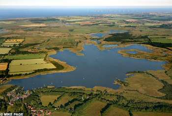
Possible threat: Horsey Mere and surrounding land could be lost as part of the plans
Dr George accepted that ministers faced "hard decisions" about how best to defend coastlines because of rising sea levels - and said the report may bring home the scale of the difficulties faced. He said beaches along the north Norfolk coast were being washed away by stormier seas and sea walls were in danger of being undermined. The Broads Society want cash spent shoring up beaches.
Under the Natural England proposal, new sea walls would be built inland - easing pressure on other parts of the coast. A spokeswoman for Natural England said the proposal was an "academic treatise" aimed at triggering debate not a "plan" - and was one of a number of suggestions put forward.
The area known as The Broads spans 74,000 acres to the north and east of Norwich and is based around 63 shallow lakes most of which were hand dug in medieval times by people gathering peat for fuel. The largest is the 350-acre Hickling Broad. It is the one of Britain's most popular holiday and boating areas and contains a wealth of bird, insect and plant life. The area is managed by The Broads Authority which is responsible for planning and maintaining waterways.
The Broads Society was set up in 1956 to promote the well-being of the area. Its members include local residents, farmers, naturalists and visitors.
Government Minister responds to MARINET members on sea defences
Joan Ruddock MP, Climate Change Minister, has responded to Mike King, MARINET member, on the question of why the UK cannot afford adequate sea defences along the east coast. Mike King believes that, like the Netherlands, the UK should be defending all of our low lying land and that we have the economic resources to do so. Joan Ruddock MP says that the Government is increasing funding for sea defences and has invited MARINET to contact the Environment Minister, Phil Woolas MP. See below for the full details.
Result at Last - A Positive Reaction from a Government Minister on the Provision of Coastal Defences for Norfolk
EDP Live Web-Site Chat
Question from Mike King (MARINET - Marine Environmental Information Network, Great Yarmouth):-
Dear Joan, In your climate change feature in the Eastern Daily Press EDP2 Monday 17 March you stated: "When it comes to coastal erosion we have got to take a hard-headed approach. It would be impossible to protect every inch of the coastline." My reply augment is why not - because: We are a rich country and the UK spends millions on lost causes i.e. the Iraqi war. The Netherlands have much more land below sea level than the UK but they defend every square metre. We are also an over populated island with land at a premium and because of the increasing demand for homes properties are still being built on flood plains and areas with out sea defences threatened by coastal erosion. The Norfolk Broads and Fen-land established fresh water wild life habitats will be destroyed by salt water egress if defences are not provided and maintained. Much of Norfolk and Lincolnshire below sea level hard won productive farm land will be destroyed and we will be more reliant on foreign produce, if defences are not provided and maintained. In the lean post war years during the 1950s after the 1953 storm surge caused severe flooding and the loss of over 300 lives an extensive programme of sea defences construction was implemented along the entire UK East coast, this included the erection of groynes and sea walls along significant sections of the East Coast which included all at risk areas. If such an extensive programme can be executed when we were so hard-up after the second world war - why is it such a problem now that we have recovered and are one of the worlds richest countries - I think it is a case of misplaced government priorities. Perhaps it will take another Storm Surge disaster to motivate the government regarding the importance of sea defences to save lives and irreplaceable land.
Reply:-
My colleague Environment Minister Phil Woolas met recently with Norman Lamb MP and campaigner Malcolm Kerby to discuss the specific issues in your area. While it is true that we cannot protect every inch of coastline it is clear that the government is commited to the sustainable protection of people and property, which is why the spending on flood and coastal erosion risk management is rising from £307m in 1996/97 to £600m in 2007/08 with further increases to £800m in 2010/11. A range of approaches to help communities adapt to the changing coastline is being pursued and we welcome your contribution which I will forward to my colleague Phil Woolas.
Question from Pat Gowen (MARINET - Norwich):-
Joan Ruddock stated in the March 17th Eastern Daily Press Feature-3 article
"When it comes to coastal erosion we have got to take a hard-headed approach. It would be impossible to protect every inch of our coastline"
Why not?
Over the past 18 years the government has benefited by over £1.6 billion from the royalties and VAT provided from the 189 million tons of sand and shingle dredged from off the Great Yarmouth coastline alone. This is far more than enough to pay for the total protection of the entire UK coastline as well as providing compensation for those who have lost their properties and living because of the erosion resulting from this damaging commercial exploitive process.
Over thirty per cent of the aggregate dredged off our coast has been exported to Holland, where such dredging is banned due to the erosion and fishing losses brought about were it so permitted.
So - why not?
Reply:-
The minister failed to answer this question.
Question from anonymous:-
According to the EDP today, hundreds of homes, thousands of acres of farmland and some of Norfolk's top wildlife sites would be surrendered to the sea under a radical plan being considered by conservation bosses to flood 25sq miles of the Broads. Surely this can't be right? (http://tinyurl.com/2oukjw)
Reply:-
These are not proposals being put forward by Defra. However, it is appropriate that the Broads Authority should consider how to meet the coastal challenges arising from climate change and engage in public debate. Please see my answer to the previous question on this issue.
Question from Pat Gowen:-
How can the government justify the continuation of approve for the dredging of many millions of tons of sand and shingle from off our coastline when it is known to be the main cause of erosion. This at a time when the (mis)Managed Retreat policy is dictating the loss of our beaches, wildlife sites, dunes, Broads and coastal villages, thus seriously impacting our economy. Further, bringing about the loss of good farming land at a time of increasing grain shortage and with the threat of further summer drought. Given Sea Rise and East Anglian land sinkage, cannot this short term profit benefit to the exploiters be seen as totally unsustainable and a major long term loss to both the economy and our environment?
Reply:-
Modelling and field studies on the impact of both individual offshore dredging licences and of the cumulative impacts of such licences have concluded that UK offshore dredging has not contributed to coastal erosion. There may be a potential impact on the coastline in relation to estuary and near-shore dredging for navigation purposes. However, in these cases, there is a clear need to balance economic and social imperatives of continued port operations with any environmental impact. We recognise the impact that the changing climate has on our coastline which is why we are developing a range of approaches to help communities adapt to the changing coastline. From 1st April 2008 the Environment Agency will have a strategic overview of all capital funding for coastal defence to ensure that works are appropriately prioritised, balancing national interests and local needs.
Lone Coastal protector is winning his case
From the East Anglian Daily Times of 27th March '08 comes this good news story by David Green of a David and Goliath by the sea situation.
£1m claim in sea defences court case
A Suffolk man locked in a war with officialdom over his efforts to defend homes from the sea expects to claim hundreds of thousands of pounds - possibly more than £1million - in compensation and damages when the case is heard in the High Court, it has emerged.
Peter Boggis, who is being prevented by Natural England, the Government's countryside and wildlife agency, from maintaining a "sacrificial" sea defence protecting properties at Easton Bavents, north of Southwold, is still awaiting the date for the full hearing of an application for judicial review. The hearing is expected to take place in the autumn and both parties have been asked for paperwork in advance.
Mr Boggis and his lawyers will contend that Natural England was wrong to extend the local Site of Special Scientific Interest to include the DIY sea defence - built using clay and other spoil brought in by lorry at a cost of nearly £500,000. Lawyers will also submit that Mr Boggis has been denied his human rights under the European convention.
Natural England claims that the building of the unauthorised sea defence prevents access, study and analysis of geological exposures in the retreating cliff face and that natural coastal processes should be allowed to take place. One battle in the war between the residents of Easton Bavents and the Government agency, has already been decided.
Charles England, tenant of a chalet in the hamlet, won an appeal earlier this month against Natural England's refusal to allow him to maintain the sea defence protecting his own property. The judge decided that the site's special scientific status was better served by protecting it against erosion than by allowing it to be destroyed. The ruling, confirmed by Environment Secretary David Miliband, means that Mr England should be given consent by Natural England to maintain defences along the 60-metre stretch of coast immediately in front of his chalet. That consent notification has yet to be received.
Mr Boggis, a retired engineer who has built defences along a 1,000 metre stretch of coast, said yesterday that when the judicial review was finally heard in the High Court he would be claiming compensation and damages running to "six or seven figures". The claim would be based on his own legal costs and damages for denial of human rights. "We are confident that justice will be done and that the right of people to protect their homes will be upheld," he said. Mr Boggis has accused officialdom of "bullying" tactics and being prepared to allow his home and those of neighbours to be destroyed "on a whim". Heather McMorland, Natural England spokeswoman, said last night: "We are unable to comment in the run-up to the court case."
The end for the Broads?
EDP 28th March '08
Hundreds of homes, thousands of acres of farmland and some of Norfolk's top wildlife sites would be surrendered to the sea under a radical plan being considered by conservation bosses. At least six villages would be wiped off the map under the proposals which would involve the flooding of 25sq miles (6,500 hectares) of the Broads. The plans, which are still at the discussion stage, were described as "devastating" by North Norfolk MP Norman Lamb and "horrifying" by Dr Martin George of the Broads Society, while Andrew Alston, who farms on the edge of the area that would be affected, said they were "political madness".
Under the proposals the sea would be allowed to breach coastal defences between Horsey and Winterton, flooding low-lying areas as far inland as Potter Heigham and Stalham, where new sea walls would be built. The area that would be affected is broadly the same as that which disappeared under water during the Horsey Floods of 1938, the most extensive floods in the area in living memory. The villages of Eccles, Sea Palling, Waxham, Horsey, Hickling and Potter Heigham, as well as parts of Somerton, would be lost to the sea, eventually reverting to reedbeds and saltmarsh to create a habitat for wildlife.
They have already been discussed behind closed doors at a conference in Norwich on climate change in the Broads, organised by Natural England and attended by representatives of the Environment Agency, Broads Authority and Norfolk County Council, plus other organisations.
The EDP has obtained a copy of the document outlining the proposals, listed as option four of four for the Upper Thurne basin in the face of rising sea levels.
"Two retreated defences would be built at Potter Heigham and Stalham and land seaward of these would be breached, creating an embayment on the coast between Eccles-on-Sea and Winterton Ness," it reads. "The total flooded areas would thus be approximately 6,500ha. The broads (Martham, Horsey, Heigham Sound and Hickling) would become inundated by the sea, fen vegetation would be lost. It is likely over time that a spit would develop behind which coastal and inter-tidal habitats would develop."
The document says that maintaining coastal defences in their current position will become "increasingly difficult and expensive", adding: "The increasingly unsustainable nature of the Horsey to Winterton frontage beyond the next 20-50 years thus opens up the possibility of re-aligning the coast as described above within this timeframe." It continues: "There is an argument for progressing straight to option four, for it can also be argued that by selecting a radical option now, the right messages about the scale and severity of the impacts of climate change is delivered to the public. However, a decision to progress immediately to option four is likely to be met with strong political resistance and the up-front costs would be large."
A Natural England spokesman said: "The report is far from finalised and we will continue to look into and identify the responses required to climate change at a local level."
Marine current turbine installed at Strangford Lough
The 1.2 MW commercial marine current turbine prototype is about to be installed in the narrows of Strangford Lough, Northern Ireland. This is a major step forward for this technology, and if the installation proves successful marine current turbines have a very promising future. See The Independent of 23rd March '08
More information can be seen at the Marine Current Turbines website at www.marineturbines.com that gives more on the installation in Strangford Lough - taking 14 days from 23 March.
Marine Reserves can help protect seabirds
The RSPB is calling for the forthcoming Marine Bill to be able to protect important sites for seabirds, and has identified some 71 sites which are particularly important. The RSPB believes that these sites should become Marine Protected Areas (marine reserves). Further details are given below.
Footnote: MARINET is also running a UK Marine Reserves Campaign in connection with the forthcoming Marine Bill. We are asking for an ecologically coherent network of highly protected marine reserves covering at least 30% of UK seas out to 200 nautical miles. If you would like to know more about this campaign, visit www.marinereserves.org.uk
Call for new law to help seabirds
Eastern Daily Press 19th March '08
Three of Norfolk's key marine habitats should be given new legal protection to help preserve wildlife such as seabirds, says the RSPB. The bird charity has named areas of the sea on the Wash and off Hunstanton and Weybourne cliffs in a list of 71 sites across the UK considered particularly important for breeding seabirds.
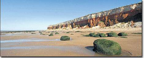
Hunstanton cliffs - one of the UK's most important sites for breeding seabirds
If such legislation were brought in, it could have an impact on offshore industries such as windfarms. The RSPB is not against windfarms per se, but believes some planned locations are badly thought out and that there is no overall wildlife conservation strategy applied to the placement of windfarms.
The charity's suggestions also include sites such as the Giant's Causeway in Northern Ireland and the North Solent off the south coast of England.
Under the current law, the land where seabird colonies nest is protected, but their offshore feeding areas are not and, as a result, their breeding levels can be threatened, says the RSPB. Only a tiny number of marine sites around the UK are fully protected, with the RSPB claiming it is as low as one square mile in every 100,000.
Kate Tanner, marine policy officer for the RSPB, said: "We have plundered the riches of the UK's seas for centuries at great cost to wildlife. The sea has shaped our islands' history, geography and culture and now, as time runs out for marine wildlife, it is crucial that we act decisively to protect the environment that defines us. From basking sharks to barnacles, cod to coldwater corals, the UK's seas contain an immense variety of threatened and beautiful wildlife. Our seas also support huge populations of seabirds, with some species occurring around the UK in larger numbers than anywhere else in the world."
The RSPB believe birds such as the black guillemot, the gannet and the roseate tern could benefit from marine-protected areas which could tackle problems such as overfishing, offshore industry and pollution. Such legislation could be established under the Marine Bill, a draft of which is due to be published soon by the government.
Other English sites named in the list are St Bees Head in the North West, Brighton to Newhaven cliffs in the South East and Lundy in the South West.
Getting the word out - Letter to the Independent
On 10th March '08 The Independent carried a news item written by Archaeology Correspondent David Keys.
It told of how in the course of dredging more sand and shingle off Great Yarmouth, twenty eight Neanderthal Flint axes came up with the 'catch'. They had remained in pristine condition on and in the sea bed for over 50,000 years. They were spotted by a keen-eyed Netherlands amateur archaeologist when the consignment of our offshore exploited sand and gravel was landed at the Dutch port of Flushing.
Commenting on the discovery, Professor Chris Stringer, Research Leader in Human Origins at the Natural History Museum, said: "The quality and quantity of material from the North Sea shows what a rich resource it is for helping to reconstruct missing phases of our prehistory. The evidence should be preserved and studied. World heritage status would help in that process."
"This is the single most important archaeological find from the North Sea. We have stopped dredging that area and have created an exclusion zone to protect the site," said Senior Hanson geologist Robert Langman.
Professor Vince Gaffney of the University of Birmingham, a leading authority on North Sea archaeology. said that The North Sea is of immense value to archaeologists and is the largest area of drowned landscape in Europe. "It's vital that parts of it should be considered as a potential World Heritage site" he said.
Whether archaeological experts meant that such offshore sites should continue to be dredged for more probable finds of the fifty to sixty thousand year old artefacts, or whether they hope that such historic sites should remain undisturbed is unclear. But whatever, this revelation provoked a great opportunity for comment by MARINET by which to inject our concern on the continuity of dredging. Thus each source reporting this issue resulted in a 'letter to the editor' from us.
The following was published by 'The Independent' on Monday 17th March '08.
The dangers of dredging
Dredging is destroying our beaches, ecosystems and heritage
Sir: David Keys' item " 'Neanderthal treasure trove' at bottom of sea" (10 March), draws attention to just how much of our heritage is being lost due to huge-scale commercial offshore dredging of sand and gravel for use as construction aggregate.
Considering the serious level of damage to fish-spawning beds and erosion along the Norfolk and Suffolk coastline resulting from this exploitative practice, it is astounding that dredging shingle and sand off our shoreline is still permitted.
Tens of thousands of tonnes have been removed, with the effect now all too obvious, added to by sea rise and land sink. We are rapidly losing our beaches, dunes and salt-marshes, all abetted by the government's "managed retreat" policy denying funding for sea defences.
The Dutch use aggregate dredged off our coast, but ban it off their own, because of damage to sea life and coastal erosion.
There has been concern about the removal of coastal gravel and sand for over 100 years. The removal of many millions of tons of naturally deposited sea-floor material cannot be sustained without changing the natural tidal current deposition pattern and the onshore wave pattern and without the draw-down of the protective sand and gravel from our beaches and offshore sandbanks.
While it appears that the increasing demand of the construction industry has absolute priority over the protection of our coastline and its people, it seems remarkably myopic to allow the Dutch to help us in the removal of an existing natural safety barrier which prevents even worse erosion than that already happening.
As the government refuses reimbursement for the coastal villages, farms and seaside industries being lost due to their policies, do we now get the Neanderthal hand-axes back to help compensate?
Pat Gowen
MARINET (the Marine Environmental Information Network), Norwich
Comment: MARINET does vitally need such national press input by which to publicise our concerns, that of marine pollution, aggregate dredging and our stance on the Marine Bill. The moral is that if any of our members or supporters seek or find issues in their local or the national press, or on a local radio or TV item that permit us to attach our comments, please take up the challenge to address these. All the background data and briefings can easily be found on our website using the search facility provided.
Growing awareness of the Shoreline Management Plan (SMP)
From North Norfolk News of 15th March '08 comes this news that awareness is now dawning on the consequences of the Shoreline Management Plan as it impacts the future different communities.
Upset over coastal planning decisions
The stark realities of new coastal defence policies are starting to bite in a popular seaside village. For a trio of bids to build new homes at Mundesley have all been turned because the plots sit on land which could be swallowed by the sea in the next 100 years.
A leading coastal campaigner last night said it was the "crunch point we have all been dreading" which could blight seaside communities - and showed the need to firm up help with compensation and relocation of threatened property.
The hat-trick of refusals saw councillors at North Norfolk District Council turn down their own scheme to redevelop toilets for five flats on the coast road, along with private projects for eight homes in neighbouring Marina Road and a single home on the Cromer Road. Council head of coastal strategy Peter Frew, who raised concerns about all of them, said: "We don't want to encourage development in areas that will be at risk. Moves were afoot to seek policies to help relocate property and government compensation, but "in the meantime we must take a precautionary approach."
Officers were already working with local people to look at community facilities which could be in long-term danger and need re-locating under the emerging new Shoreline Management Plan. It only seeks to protect the established major resorts of Cromer and Sheringham over the next century, living even well-established Victorian holiday villages like Mundesley to the mercy of the sea as its defences are abandoned.
At Mundesley the church, village hall and library were all on the seaward side of the coast road, said Mr Frew. Although not immediately at risk they would need moving in the future, which seeking replacement safer sites further inland. "It is not an easy situation," said Mr Frew, who is one of the nation's leading coastal experts, and serving on national working parties looking into the question of coastal management polices and compensation.
Policies to replace key community facilities and businesses are included in a draft new Local Development Framework planning blueprint awaiting approval by a government inspector. Once that decision was known in May there would be consultation sessions in coastal villages affected - Weybourne, Overstand, Mundesley, Happisburgh, and Bacton.
Co-ordinator of the Happisburgh-based Coastal Concerns Action Group Malcolm Kerby said: "Things are starting to bite." The flurry of refusals at Mundesley were the "crunch point we have all been dreading." He admitted that communities could have property prices blighted by up to 30pc, but that the answer lay in the hands of the government. There was a need for "social justice" through helping communities relocate inland and 100pc compensation, like that being given to people losing homes to the new Stansted runway. Mr Kerby said the local council was stuck in the middle ground between adhering to government-led coastal policy and trying to protect its local people. "We need the government to bring its coastal planning system up to date. I feel sorry for anybody whose plans are turned down. But there are going to be casualties on the route," he added.
WWF launches sustainable seafood website
Finding sustainably sourced fish may sound like yet another challenge when doing the weekly shop. But it's vital that we pay attention to the kind of fish that ends up on our plate. According to recent reports three quarters of the world's fish stocks are either fished to their limit or overfished. To encourage more shoppers to make the right choices when it comes to fish, WWF has launched a new website "Stinky Fish". It has information on which species to avoid and a simple guide to buying sustainable seafood.
For full details, see: www.wwf.org.uk/news/n_0000004725.asp WWF is also asking shoppers to fill in a scorecard which enables you to report back to WWF on the sustainable nature of the fish available at your supermarket. This scorecard is available from the WWF website (address given above).
Loss of Norfolk's Biodiversity
Steve Downs report in the Eastern Daily Press of 7th March '08 of the rapidly approaching loss of Norfolk's Wildlife sites
Climate doomsday threat to wildlife
Habitats and rare species are "doomed to disappear" from the Norfolk coast as climate change tightens its grip - and it is "pointless" trying to protect them, it was claimed today. Protected birds including the iconic bittern will be squeezed out as freshwater habitats guarded by defensive walls are inundated by saltwater because of sea level rises of up to 80cm by 2080. Other species will arrive and thrive as temperatures soar, rainfall increases and the shape of the coast changes, according to Tim Venes, manager of the Norfolk Coast Partnership.
The warnings came as the partnership celebrated 40 years since most of the Norfolk coast was designated by the government as an Area of Outstanding Natural Beauty (AONB). The designation was a pivotal moment for the coast, giving it official protection against planning incursions and allowing a balance to be achieved between the needs of the native wildlife and human visitors.
But Mr Venes said the coming years were set to provide a "huge challenge", with change "forced upon" the coast. He said: "We don't really know what lies ahead. Coastal change has been going on for thousands of years, but it looks as though sea levels are going to rise more quickly. We are going to have to deal with that." He added: "In pure sustainability terms it would be pointless to try to protect things on the coast that are doomed to disappear. We might lose some species that the area is particularly known for, but we might gain some others. Things will be forced upon us."
John Hiskett of Norfolk Wildlife Trust said the county would have to end its reliance on man-made defences and the increasingly desperate efforts to repel the sea. He said: "Freshwater habitats that are currently protected by sea walls will gradually be replaced by salt marsh and other coastal habitats. At Cley, this process is already starting to happen as the shingle ridge adopts a natural profile and gradually moves inland." Mr Hiskett also called for "planned retreat now" of the rare dunes at Holme - rather than living with the "uncertainty of a future catastrophic breach".
Planning permission in vulnerable flood zones
The level of myopia demonstrated by those aiding and abetting habitation in areas to be lost from flooding, inundation and erosion is quite remarkable. Are they really so unaware of the enforcement of the SMP, ongoing dredging induced erosion, sea rise and land sink? The same can be held to be true for all the housing now being built on inland flood plains of course, most of which will be dependent on marine derived aggregate. The 'Eastern Daily Press' of 3rd March 2008 comments upon this.
Ignore the sea, planners told
New flats should not be built at a seaside village because the site could be swallowed by the sea, says a coastal expert. But planners will be told to ignore the advice and give the homes at Mundesley the go-ahead later this week. The scheme is for five flats at Marina Road on the site of toilets which are due to be knocked down and replaced nearby.
The council's head of coastal strategy, Peter Frew, has warned planners that emerging long-term coastal defence strategy meant it was "highly probable" it would not be able to get funding to maintain or renew the local sea wall. The concrete structure was 120 years old, in variable condition, and had a life of three to 20 years. Mr Frew adds in a report to planning councillors: "It can be expected the site will be at risk from erosion well within 50-100 years, and that the coast road will be lost sooner." But the report says that after seeing legal advice "it is not considered appropriate to refuse permission on coastal erosion grounds".
Legal services manager Emma Duncan said the shoreline management plan (SMP) was part of the new local development framework planning blueprint which had not yet been adopted, and she was keen to ensure the planning authority did not "pick and choose" elements and apply them prematurely, in particular the SMP. The planning committee should work to the existing local plan, which highlights a 60-year erosion risk line which the Mundesley site was beyond. Thursday's east area development committee will be recommended to approve the plan, submitted by the council itself.
The flats plan has parish council support, but with concerns over the "overpowering" design and lack of car parking, and there are objections from six people highlighting the loss of toilets, and overdevelopment.
An appraisal, however, says the toilet loss was only short term, with replacements due 50m away, and others available in the village. It also says the building is comparable with neighbouring three-storey buildings, and the "minor shortfall" in parking spaces was unlikely to cause a highway problem.
Hallsands - hype and facts
When BBC first broadcast the superb 'Coast' programme, which did much to portray the value and wonders of our coastline, they included the story of Hallsands, that delightful Devon Village destroyed in 1917 by dredging. (See Marine Aggregate Dredging : Briefing Paper No.1 at www.marinet.org.uk/mad/madbrief.html. , the scientific paper under 'Why are our Beaches eroding?' at www.marinet.org.uk/mad/coastalzone07.html and 'Historic Evidence' under www.marinet.org.uk/coastaldefences/mikekingacag.pdf )
Hallsands was the very first case evidencing the erosion resulting from offshore dredging, and that initial BBC TV programme accurately portrayed it as such. But when 'Coast' was repeated, all mention of the cause of the village destruction was surgically removed and replaced by a new 'sanitized' version cutting out all mention of the factual cause and blaming the loss exclusively on a sudden overnight storm.
Read more about MARINET's protests over this at www.marinet.org.uk/mad/hallsands.html#hs
Sharks need Marine Reserves or face extinction
A recent paper at the American Association for the Advancement of Science has argued that shark populations are being so adversely impacted by modern fishing practices that if marine reserves are not established to protect shark species they will shortly face extinction. Recent studies have shown that all shark populations in the north-west Atlantic Ocean have declined by an average of 50% since the early 1970s. For full details of this article see The Guardian 18th February 2008
It pays to protest!
The Eastern Daily Press published the following on 19th February '08, suggesting that there may be a few listening ears out there after all.
Coastal communities ponder 100 year plan
Coastal communities threatened by the North Sea could be given a reprieve after villagers demanded they be protected. A shoreline management plan (SMP) is due to be in place by 2010 which will spell out how more than 2,000 homes from Sheringham to Lowestoft will be protected from coastal erosion in the next 100 years. But the scheme will sacrifice many villages to the mercy of the waves because it says it is not practical to protect them.
However, following pressure from residents, Yarmouth Borough Council will modify its SMP to protect the two coastal settlements of Hopton and Scratby instead of consigning them to the sea. Councillors will also ask ministers to compensate anyone who loses their property because sea defences are given up.
After a series of highly charged public meetings at the end of last year, the council changed its mind about surrendering Hopton and Scratby and will discuss a new SMP tomorrow night which will then be sent to the government for implementation.
So instead of the controversial policy of no active intervention, erosion will be fought off as the impact on businesses and homes is properly explored and accepted by all parties involved, including the possibility of relocation and financial aid. The council will also demand that ministers provide compensation to home owners or businesses that succumb to waves because sea defences were surrendered up.
Jim Bratten, from the Scratby Coastal Erosion Group, said that he was pleased by the changes to the SMP as it give his threatened community a better chance of surviving the power of the North Sea. He said: "This leaves the door firmly open for future discussion about coastal erosion."
The council's SMP will still say that sea defences at Yarmouth, Caister and Gorleston should be held and places such as Winterton, Hemsby and Newport will be left to their own devices.
Pat Gowen, from the Hemsby-based North Sea Action Group, said that if nothing was done to protect his village then much of it would be lost if there was a repeat of the 1953 floods or last November's tidal surge.
North Norfolk District Council will also approve its SMP on Wednesday and recommends that Sheringham, Cromer, Mundesley and Overstrand are protected while other communities such as Happisburgh, Trimingham and Weybourne are not.
Last year Waveney District Council approved its plans for submission to the government and said that sea defences for Corton, near Lowestoft, should be held for the next 20 years only.
Geographical Magazine reports on marine aggregate extraction
The March 2008 edition of Geographical, the magazine of the Royal Geographical Society, has produced an article on offshore aggregate extraction in the UK, under the title: Shifting Sands - suck it and see : what effect is dredging having on the British seabed?
For a full copy of the text of the article, see www.marinet.org.uk/mad.html#ss
'Save our coast' call
Eastern Daily Press 14th February '08
People from across the region were last night urged to join a day of mass protest against plans to abandon flood defences along the beautiful north Suffolk cost. About 1,000 protesters are expected to converge on the beach at Walberswick on Sunday to spell out a huge human SOS and send out a message of defiance to environment chiefs.
Organisers of the Walberswick SOS campaign have received support from within Suffolk and around the world, but yesterday they issued a heartfelt plea to the people of Norfolk to stand shoulder to shoulder with them.
Karen Solloway of the campaign group, said: "We are sending out a message that we are not prepared to let our livelihoods be washed away into the sea. We are all in this together to create a mass public outcry. We are the little people, but we are going to make a big noise. We have had support from the whole of Suffolk, but what we now want is the backing from the people of Norfolk."
The Environment Agency revealed plans to abandon flood defences along the Blyth Estuary over a period of 20 years, after insisting it could no longer afford to carry out repairs. However, it will leave thousands of acres of land, homes and roads around the Walberswick, Southwold, and Blythburgh areas under threat from flooding.
Mother of-four Mrs Solloway said the village, which has a population of about 600, relied on income from the hundreds of thousands of visitors every year to survive. It is feared the village's beach, footpaths, harbour and other beauty spots will be wrecked by flooding and leave it virtually an island.
Protesters have been asked to arrive at the beach at 11.30am on Sunday where they will be registered before taking part in the human SOS, which will be filmed from the air.
Mrs Solloway added: "We want the people of Norfolk to join us and stand shoulder to shoulder with us on the beach because they are also under threat from the sea. I want to be able to look my children in the eye in years to come and say we did everything possible to protect this place. We are going to fight this."
A spokesman for the Environment Agency said: "We are very aware of the feelings of some of the people living close to the Blyth Estuary and sympathise with them. But we also have a duty to the public purse to spend money where it does the most good and, unfortunately, we cannot justify spending £34m on the estuary when that money is needed to protect thousands of properties across the country."
The consultation on the Blyth Estuary plans ends on February 29.
For more details about the campaign, visit www.walberswicksos.co.uk
From the 18th February East Anglian Daily times comes the report of the event.
Protesters' SOS in battle of the Blyth

The SOS from the air
It is recognised worldwide as an area of outstanding natural beauty. And with bright sunshine and clear water, yesterday was a perfect day to spend in Walberswick. But the tranquil village and peaceful beach was attracting more people than usual yesterday - and it was not just because of the weather.
For more than 1,500 people joined together to protest against Government plans to stop maintaining sea defences - which they say could lead to the picturesque village and surrounding Blyth estuary being washed away for future generations.
Protestors helped form an SOS outline, around 50 metres long and 30 metres high, to call for the Government to "Save Our Shoreline".
The protest came as Environment Secretary Hilary Benn is under pressure to explain how a sea wall outside his family's home on the Blackwater Estuary in Essex came to be repaired last autumn, while his department is proposing to abandon Southwold Harbour and Walberswick.
Landowner Andrew Blois, whose family helped build the initial flood defences in north Suffolk 400 years ago, said much of his 4,500 acres of land is under threat if the Government proceeds with its plans. He said: "It is about preserving Walberswick and Southwold Harbour and everything that people around here enjoy and today is the prime reason - this is what Walberswick is all about. "It is this community, the beach and the sunshine, and if the Environment Agency continues the way it is we will lose a large proportion of it, which will devastate people's lives and businesses and the whole community. I hope the protest has been a resounding success. It is lovely to see so many people come out here and the enthusiasm shows the commitment that everybody has to the community, and that is what makes Walberswick so special."
Protestors say they are demanding three things from Defra - which funds the Environment Agency. They want a commitment to fund maintenance of the shingle bank between Walberswick and Dunwich. They also want breaches to all the flood bank defences on the River Blyth repaired immediately and a commitment to fund maintenance and restoration of all Blyth flood bank defences in the future.
Out showing his support was Conservative MP for Suffolk Coastal, John Gummer, who said it was a "wonderful protest by local people". He added: "I am so pleased. It is yet another example of the determination of people in Suffolk Coastal and Waveney to fight for the protection of the coastline and the rivers. "The reason that the Environment Agency and Government have developed this unacceptable plan is because they have not managed the river defences. It is like a householder not dealing with the guttering and wondering why it costs £100,000 to mend the house when they are not prepared to spend the money in the first place."
Organisers of yesterday's protest said they wanted to see a chain reaction against the policy of retreat and giving into the sea and hope that other communities around the British coast will follow with their own SOS protests.
Malcolm Kerby, from Coastal Concern Action Group in Happisburgh, Norfolk, said: "I have come today to show solidarity because it is not just here that is affected, it is the whole East Anglian coast. These people are here to protest about things much more far reaching than Walberswick and Southwold. It is about the effect that this plan for the Blyth estuary would have on the wider economy of the area because I think it would decimate it."
Luke Jeans, one of the main organisers of the protest, said he was confident the SOS protest would have an effect. "This is important because ever since the Environment Agency announced that it was withdrawing funding there have been a lot of committees set up to put argument's to them but this is the first time that we have had people power. I think the turn out has been fantastic and is everything that we hoped for."
The Environment Agency, which advises and implements Government policy on environmental issues, thinks that maintaining defences in the Blyth estuary is unsustainable and uneconomic because it will cost tens of millions and protect few properties. It has produced a draft strategy and the consultation period is due to end on February 29.
Charles Beardall, the Environment Agency's area manager, added: "We do genuinely understand the concerns of the local community. They have a right to protest and make their views known and we will listen. But the bottom line is we feel the sea walls will last for about another 20 years and after that period the cost of replacing them - about £34million - is simply uneconomic. The money would be better spent elsewhere." He said about 40 properties would be affected and officials would advise owners on protection. "We face an enormous bill because of rising seas levels," added Dr Beardall. "A lot of existing small sea walls simply will not cope and we face very difficult decisions how to spend money on defences."
In a letter to Defra written to accompany the demonstration, protesters said:
"We, the people of Walberswick, are sending out an SOS to this Government and calling on Defra to save our shingle ridge, save our marshes and save our community by reversing its recent decisions to retreat and let the sea in all around us. We are not going to stand by and let Walberswick beach and beautiful surrounding areas wash away into the sea. They will try to argue that there is only so much money to go round - but we are not asking for more Government money. We are asking them to spend our money better. It is financial madness not to spend money now on defences and then end up spending 10 or 20 times as much in a few years' time on raising the A12 at Blythburgh to keep the east coast open when the road gets washed away."
The letter added: "We are sending this SOS to all the people who know and love Walberswick so that they can join us in sending a message of their own to Defra - a message that together we will not retreat, we will fight them on the beaches and we will never surrender. "This is not just an SOS for our village under threat. We are calling on every other community on the coast of Britain which is threatened by the lack of funds for sea defences to send its own SOS to the Government and to keep sending them until they see sense."
Earth's "Eighth Continent" in the Pacific Ocean
A recent news report records how a huge area of the Pacific ocean is being filled with plastic rubbish. The ocean's currents create an area of sea in mid-ocean with a gyre which in turn creates a vortex and causes floating material to be trapped at that spot. Thus flotsam, largely vast quantities of discarded plastic, is forming an artificial island, see http://thetyee.ca/News/2007/11/21/PacificGarbagePatch/
If you want to play your part in clearing up plastic rubbish from our seas and beaches (thus preventing plastic killing marine life), then contact Surfers Against Sewage www.sas.org.uk/campaign/marine_litter/beach_cleans.php
Another threat to our vulnerable coastline
Just as if the stripping of aggregate was not enough, here is news of a further attempt to allow the sea to impact our vulnerable coastal villages which appeared in the 16th February '08 Eastern Daily Press in this article written by Christine Cunningham. But it needs to be said that MARINET does not believe for one moment that the miscreant was working on behalf of the dredgers, the Environment Agency, DEFRA, the MFA or those who produced the Shoreline (mis)Management Plan.
Community service for sea defences thief
A thief who stole sea defences protecting a Norfolk coastline under severe threat from erosion was yesterday ordered to do 200 hours unpaid work and the judge said it would "be rather nice" if the work involved him helping with the sea defences.
Rodney Frary, 39, left his fellow villagers of Happisburgh flabbergasted when he stole metal work from the sea defences on the beach which itself has become an international symbol in the battle against coastal erosion in recent years. Frary was spotted using an angle grinder to remove steel from the sea defences and loading it into his 4x4 on the beach, Norwich Crown Court heard.
Frary, of Coronation Close, Happisburgh, admitted stealing the metal work from North Norfolk District Council on August 19 last year. His case was adjourned until yesterday for reports.
Recorder Guy Ayers told him he considered it a serious matter. "I hope you realise you have not only let yourself down but the community in which you live." He ordered him to do 200 hours unpaid work and said: "It would be rather nice if it was helping to do the coastal defence work." He also ordered Frary to pay £1,000 towards prosecution costs.
Mankind having a profound effect on the world's oceans
An international scientific team has published the first ever comprehensive map which charts the combined impact of human activity (fishing, pollution, climate change) on the planet's seas and oceans. The map shows that over 40% of the world's marine regions have been significantly altered, with only 4% remaining in a pristine state. The North Sea is one of the most heavily affected marine areas.
By Nic Fleming, Science Correspondent, in Boston: Daily Telegraph 15th February 2008
Man's effect on world's oceans revealed
Almost half of the world's oceans have been seriously affected by over-fishing, pollution and climate change, according to a major study of man's impact on marine life.
An international team of 19 scientists have published the first ever comprehensive map showing the combined impact of human activity on the planet's seas and oceans.
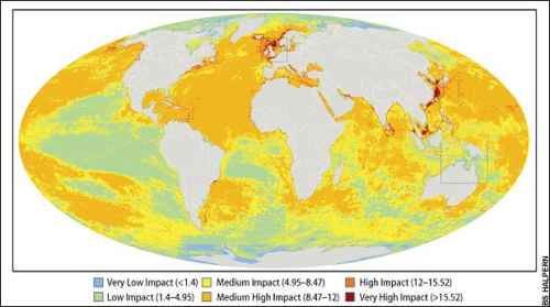 World map showing Man's affect on the planet's oceans
It shows that more than 40 per cent of marine regions have been significantly altered, while just four per cent remains in a pristine state.
Previous studies have largely focused on the impacts of specific activities such as pesticide runoff or fishing, or have looked at damage in certain areas.
The North Sea is one of the most heavily affected regions, along with the South and East China Seas, the Caribbean, the east coast of North America, the Mediterranean, the Red Sea and the Persian Gulf. The least affected areas are near the poles.
Dr Ben Halpern, of the University of California, presented the new findings at the American Association for the Advancement of Science (AAAS) conference in Boston. Dr Halpern said: "This project allows us to finally start to see the big picture of how humans are affecting the oceans. The big picture looks much worse than I imagine most people expected. It was certainly a surprise to me."
Activities and impacts included in the study include fishing, ocean acidification caused by pollution, temperature change, species extinctions and invasions, and the shipping, oil and gas industries.
The researchers developed models to quantify and compare how 17 human activities affected marine ecosystems. For example fertiliser runoff has been shown to cause significant damage to coral reefs but has less effect on kelp forests. They gathered data from across the world and collated the results to give each area a score for man-made damage and changes. The results, published in the journal Science, show that 41 per cent of the world's oceans and seas have been significantly affected by multiple human activities. Coral reefs, seagrass beds, mangroves, rocky reefs and shelves are among the most seriously altered ecosystems.
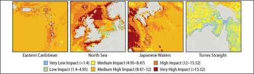 Maps showing the marine areas hardest hit bay the affect of Man
The team hope their work will provide information to help policymakers decide on priorities for conservation action.
Dr Kimberly Selkoe, of the University of Hawaii, said: "Conservation and management groups have to decide where, when, and what to spend their resources on. Whether one is interested in protecting ocean wilderness, assessing which human activities have the greatest impact, or prioritising which ecosystem types need management intervention, our results provide a strong framework for doing so."
Coastal regions were shown to be particularly badly hit. The North Sea was the 24th most affected region of 232. The effects of over-fishing in the North Sea have been well-documented, while the close proximity of heavily populated areas, shipping, oil and gas extraction have all affected a region that is relatively shallow and enclosed, and therefore slower to repair damage.
Co-author Dr Mark Spalding, a marine scientist at the conservation group Nature Conservancy, said: "What is surprising is the truly global spread of human impact. But it's not all doom and gloom. In some areas, such as the Great Barrier Reef, strong integrated conservation measures are being introduced. The map provides a challenge for us to start to think seriously about conservation and management, and gives us pointers to the priorities and different states of urgency of response required."
Yare flood barrier back on the agenda
John Welch, Eastern Daily Press, 15th February '08
A multi-million pound flood barrier that would protect thousands of Norfolk homes from rising sea levels is back on the agenda, 13 years after plans were mothballed. The Environment Agency is being urged to reconsider a barrier across the River Yare in order to protect Yarmouth and the Broads from flooding as the threat from climate change intensifies.
The Broads (2006) Internal Drainage Board is warning that existing flood walls and banks will not offer enough protection if sea levels rise as predicted.
The board's chairman Henry Cator warned: "If we don't make this investment we must accept that whole communities become derelict." He said the tidal surge at Yarmouth last November had demonstrated the vulnerability of the Broads to flooding by the sea.
"If the high tide and the surge had coincided there is no doubt there would have been extensive flooding in Great Yarmouth and Broadland. What we are suggesting is that in order to keep a sustainable drainage system the only option for the long term to protect that area from inundation by the sea is to have a barrier at Great Yarmouth."
Opponents of such a scheme have previously expressed fears that it would hamper trade at the port, but Mr Cator said construction of Yarmouth's outer harbour provided a fresh opportunity to look again at the benefits of a barrier. In a letter he urges the Environment Agency to review its position and to launch an "engineering, economic and environmental feasibility appraisal as soon as possible."
He told the EDP: "It's not just about protecting wildlife; it's protecting communities and life itself. These are communities in which people don't just live but work. I hope that people will take it seriously. We all know there are tremendous pressures on government for funding at the moment, but it's an investment you are making in this part of the world for the next 100 years - a long-term investment that I believe our grandchildren will be grateful for."
Mr Cator said he favoured a barrier as close to the mouth of the Yare as possible.
Plans for a flood barrier to protect Broadland were mooted as long ago as 1955, two years after the East Coast floods killed more than 300 people. In 1993 the Norfolk and Suffolk Local Flood Defence Committee overwhelmingly backed a Yare barrier at Yarmouth as the best option, but the National Rivers Authority concluded the cost of such a barrier - estimated at £25m, plus a further £57m for bank strengthening - could not be justified. The flood defence committee changed course, and in October 1994 dropped plans for the barrier, pledging to "keep the issue under review".
Dr Martin George of the Broads Society welcomed news that the barrier was on the agenda once more. "We haven't had a formal discussion about the Yare barrier but I think if we did a straw poll we would find our members in support of some kind of structure. The storminess of the North Sea is going to become much greater than it is at present, and storm surges create a huge threat primarily to the lives and livelihoods of people in Gorleston and Great Yarmouth."
Dr George's preferred site for a barrier would be about halfway down the Haven in the Lower Ferry area. He said pressure in favour of the scheme was building up, but that cost was likely to be a major stumbling block. "It will probably not happen in my lifetime. I think it will take a few years yet."
Jim Shrimplin, Yarmouth Borough Council's cabinet member for the environment, said: "It would certainly protect low-lying areas such as Cobholm from river flooding. "If it could do that and prevent over-topping of riverbanks inland and saltwater infiltration into upper rivers and marshland it's got to have some merit. It's not a scheme that could be funded locally. It would need government or European funding."
Steve Hayman of the Environment Agency said a £100m programme of flood defence improvements throughout the Broads was already under way at a time when money was short. "I'm not saying the case for the barrier won't be reopened in the future but we're not actively looking at this at the moment," he said. "We will hear what people have to say. Just carrying out studies to investigate these things costs a lot of money so we have to be really confident that there's a good case before investing in further studies. The outcome last time was that the economic case for the barrier could not be justified. Obviously we hear a lot about climate change and there are issues for the Broads from sea level rise. It's certainly not been forgotten."
Crown Estate penalises offshore fixed renewables
From the Times Online 11th February 2008
Offshore wind farms to generate £100m windfall for Crown Estate
The Crown Estate will earn windfall profits of at least £100million a year from Britain's booming offshore renewable energy industry. The estate, which owns the foreshore and seabed around the UK, has already signed contracts worth tens of millions of pounds with operators of offshore wind farms.
Rents from the siting of wind turbines are only the beginning of a vast new commercial opportunity for the Crown Estate. In addition to a huge expansion in offshore wind power and the development of tidal power, the estate will profit from the laying of subsea cables and an emerging industry in storing carbon captured from coal-fired power stations.
Rob Hastings, the Crown Estate's marine director, said that the group, which manages land and assets owned by the Queen but pays most of its revenues to the Treasury, charges offshore wind operators an annual "rent" of just under 1 per cent of the value of the electricity generated.
The Crown Estate has full ownership of the seabed for 12 nautical miles around the UK and further rights out to the extent of Britain's continental shelf, at 200 miles.
Privately, one of Britain's top six utilities estimates that the Crown Estate stands to earn upwards of £100million a year from offshore wind licences alone if the Government is to achieve its stated aim of generating 33 gigawatts of power from offshore wind energy by 2020. Further revenues could be generated from tidal energy developments, such as the Severn barrage, carbon storage opportunities and subsea cabling - for which the Crown also charges a lease. "[The seabed] is quite a valuable commodity," said Mr Hastings, who added that the group had signed its first offshore wind lease in 2001. A third round of bidding for new licences is under way and due to close in September. He emphasised that the bulk of the proceeds would go to the Chancellor, while other funds would be set aside to help with long-term management of the seabed.
Nevertheless, the windfall is raising eyebrows in the power industry. "It's not as if there is an annual maintenance charge for the seabed," one source said.
Britain's heavily subsidised wind energy industry is expected to form a key part of its efforts to meet targets on tackling climate change announced by the European Union last month. The UK has been set one of the toughest targets, amounting to an increase in electricity generation from renewable sources to 35-40 per cent, from just over 4 per cent at present. There is about 500-600 megawatts of generating capacity in existing offshore windfarms around the UK. This is expected to increase to 7,500 megawatts by 2015, but in December John Hutton, the Business Secretary, set out plans to more than quadruple this to 33,000 megawatts, or 33 gigawatts, by 2020.
Carbon capture and storage could represent an equally valuable source of revenue for the Crown Estate. Captured carbon from coal-fired power stations would be piped out into the North Sea for storage in rock formations in former oil and gasfields.
"The rights to storing it would be vested with the Crown Estate," Mr Hastings said. However, the legal framework surrounding this emerging industry is unclear and new legislation is being drawn up.
Britain's first Tidal power farm - off Anglesey coast
Npower Renewables have teamed up with Marine Current Turbines (MCT) to propose seven tidal current turbines generating 1.5 MW three km north-west of the coast of the Anglesey in an area known as the Skerries.
MCT's earlier plans www.marinet.org.uk/refts/mct.html were for ten 1.2 MW turbines, as designed for the Strangford Lough prototype, and to erect their commercial wind farm in the Skerries from 2008. But delays in the Lough and a change in commercial partners have caused the schedule to slip - and scaled down the original talk of tapping 100 MW of the total 180 MW.

However, in the interim, R&D has produced up-graded turbines generating 1.5 MW, which will be erected on monopiles in 25m deep water. The monopile and housing will protrude 9 m above the mean tide height, as pictured.
Npower and MCT have formed a company SeaGen Wales and say they hope the tidal farm could be commissioned as early as 2011 or 2012. Paul Cowling, managing director of Npower Renewables, said he believed the Skerries project provided the perfect solution for exploring new green power technology.
"Tidal stream may be a young technology, but we are convinced by the results of MCT's work to date, that this is a technology with the potential to make a valuable contribution to UK renewable energy supplies, and the battle against climate change."
The Skerries site is advantageous because of the strong currents and location close to the national grid to Wylfa power station and 14 km from the port of Holyhead.
A full assessment and detailed surveys of the surrounding environment and tidal resources will get underway shortly and continue through the rest of 2008.
Neil Crumpton, of Friends of the Earth Cymru, welcomed the project as a boost for green power sources. "Britain has a great tidal stream resource along its coast. We need to develop these renewable energy resources - it can't be beat," he said.
Protecting The Wash
In the Eastern Daily Press of 2nd February, Chris Bishop wrote the following article, good news for a very precious environment.
Agreement to safeguard The Wash
Fishermen and conservationists are joining forces to safeguard the future of The Wash. They have signed a ground-breaking new agreement to work together to protect both jobs and wildlife in the internationally-important estuary.
A new fisheries management plan has been drawn up for the Wash shellfish industry governing quotas, fishing methods, vessel sizes and stocking levels. It covers boats gathering both cockles and mussels, which operate in close proximity to wading birds and over-wintering waterfowl which feed or roost in an around the estuary.
Matt Mander, clerk and chief fisheries officer with the Eastern Sea Fisheries Joint Committee, which regulates an industry landing up to 6,000 tonnes of shellfish from The Wash each year, said: "It's pretty significant. It's the first area where formal management policies have been agreed that will meet the expectations for nature conservation and allow a viable commercial fishery to continue operating. The development of these policies is an important milestone for the industry, natural environment and local people. Our work is already making a positive impact, enabling Natural England to change the conservation status of many parts of the SSSI, which is fantastic news and a huge step towards where we want to be in the future."
Over exploitation reduced shellfish stocks to what was believed to be an all-time low in the mid-1990s. Thousands of oystercatchers died and by 1997 the cockle fishery was forced to close and natural mussel harvests were the smallest on record.
The sea fisheries committee has worked with Natural England to draw up the new policies. Both believe they mark a turning point in the health of the Wash.
Shaun Thomas, Natural England's regional director for the East of England, said: "The Wash is one of the most outstanding Wetlands in Europe and of exceptional importance for its wildlife and biodiversity. Through working closely with the Wash fishermen and the ESFJC, sustainable management of Wash shellfisheries has been secured. We will continue to work with the industry including fishermen and fisheries managers in other important sites to achieve similarly effective agreements. The Wash is an example of how, through partnerships, we can achieve a sustainable future for both the natural environment and the economy."
Bob Garnett of Kings Lynn Fishing Industry Co-operative said: "Agreeing these policies is important as it has enabled the industry to have direct involvement in management of these fisheries upon which our livelihoods and also the wildlife of the site which we live and work side by side with, depends."
Walberswick villagers plan SOS protest
Anyone who has ever visited the truly delightful Suffolk Coastal Village of Walberswick, opposite Southwold over the Blyth Estuary, will know what a treasure this is, and will recognise that to lose this due to DEFRA's myopic and inconsiderate dictation would be an unthinkable disaster.
The East Anglian Daily Times of 2nd February 2008 published this item on the issue written by Mark Lord.
Villagers in a picturesque seaside village are to send an SOS to the Environment Agency in a public protest at the withdrawal of funding for river defences. Residents in Walberswick will be lining up for a giant human SOS on the beach to voice their anger at the agency's decision to no longer maintain flood protection along the Blyth Estuary.
It claims the costs of repairing the defences are greater than the benefits, although the move will affect large areas of Walberswick, Southwold and Reydon. Villagers - together with anyone "who loves the place and want to help protect it" - will be holding the public protest on February 17.
Protest spokesman Karen Lee said: "It feels like the Environment Agency, and Defra, is abandoning us to the waves and we're not going to stand for it. News about breaches in the sea wall or news about the River Blyth flooding always seems to miss the bigger picture - the reality for us sitting here in Walberswick is that we're under threat from all sides - the river, the sea and the estuary between us and Dunwich that the Environment Agency wants to create. Anyone who's been here knows the magic of the place. The village has a wonderful, vibrant history and as a community we're not going to stand by and see its future washed away. We are a village under threat and we're crying out for help."
The Environment Agency has said maintaining the defences on the Blyth estuary cannot be justified when there are more urgent projects elsewhere in the country. It is currently in a consultation period of a draft strategy for the maintenance of flood defences within the Blyth Estuary which ends on February 29.
Anyone wishing to get involved in the Walberswick campaign should visit www.walberswicksos.co.uk.
Following on to the above article, the following item by Mark Lord appeared in the 5th February East Anglian Daily Times.
Thousands back SOS flood campaign
The organisers of a campaign to save a north Suffolk seaside village from the ravages of the sea have received overwhelming support for their campaign after it was unveiled at the weekend.
Following its launch in the EADT on Saturday, February 2, residents of Walberswick have been encouraged by the huge amount of feedback they have received since announcing their SOS campaign. The campaign aims to put public pressure on the Environment Agency and DEFRA to reverse the recent decision to withdraw funding for maintenance of sea and river defences around Walberswick and along the Blyth Estuary. Organisers are asking the public to take action by joining them on Walberswick beach on Sunday, February 17 at 11.30am to show the level of opposition to the proposals to abandon the area to flooding.
Campaign spokesman Luke Jeans said: "Readers from as far away as Scotland, Holland and even New York have already taken the time to read the East Anglian Daily Times online and go to our website to pledge their support and send letters to Phil Woolas at DEFRA. "We are going to make a giant human SOS sign and we need everyone who loves the place to join us. We want to see people power at its best."
Anyone wishing to get involved in the Walberswick campaign should visit www.walberswicksos.co.uk
Severn Tidal Power - Barry & Vale FoE welcome the feasibility study
Barry & Vale FoE welcome the Welsh Minister, Jane Davidson's announcement (below) of a feasibility study into Severn tidal power. The wide terms of reference to cover all tidal schemes and the caution over a tidal barrage shows that the Minister has listened to criticism of the giant barrage and is keeping options open over alternative schemes including the 'Shoots' barrage near the second Severn crossing. See www.marinet.org.uk/refts/7estuarydebate.html
The mega-barrage from Lavernock to Brean Down could not be up and running by 2015 when the electricity shortfall peaks. Tidal impoundments or self standing lagoons might be built by then, while tidal stream turbines can be installed from 2010 onwards.
The mega-barrage would inevitably be a mega development project - not just because of the huge scale of construction with linked roads, power-lines and on-shore working site, but also because the politicians see associated development projects offering thousands of jobs. The damage to the rural eastern Vale is widely feared and strongly opposed.
There are several better variations of a barrage, smaller in scale and designed to deliver electricity when needed. When storage capacity is included, they can be phased to meet short-term fluctuations in demand and well as the daily variation. See www.marinet.org.uk/refts/tidalnews.html This can save CO2 wasted by running coal and gas fired stations on standby and at sub-optimal levels.
We welcome the Minister's announcement that the major part of the study will be a "Strategic Environmental Assessment". This sets the study on a proper basis that should be open and fully participative. The first part is to decide on the scope of the SEA. Unfortunately this is to be led from England by the Department of Business, Enterprise and Regulatory Reform (DBERR) so Vale of Glamorgan organisations need to press for proper and meaningful involvement.
The terms of the feasibility study are at www.berr.gov.uk/files/file43810.doc
Tuesday, 22 January, 2008 W080039-ESH
Severn Tidal Power - study announced by Jane Davidson
The contribution which tidal power could make to combating climate change while addressing the future energy needs of Wales will be put under scrutiny in a comprehensive feasibility study, Environment, Sustainability and Housing Minister Jane Davidson announced today (22 January).
Launching the feasibility study into tidal power in the Severn Estuary, the Minister said: "Addressing climate change is one of the Welsh Assembly Government's highest priorities and I am determined that we will do everything we can to secure reductions in greenhouse gas emissions. One of the ways of doing this is to increase the amount of our electricity generated from renewable sources, and harnessing tidal power in the Severn Estuary could provide us with a long-term source of carbon-free electricity for Wales.
"The Sustainable Renewable Energy Route Map for Wales, which I will be launching next month (February), will give us the opportunity to set a lead amongst small nations as it sets out proposals for moving Wales towards self-sufficiency in renewable electricity generation whilst at the same time driving forcefully towards much more energy efficiency.
"To have a chance in tackling climate change we must implement energy-related policies which will allow us to move as quickly as practicable to a low carbon energy economy in Wales.
"But harnessing the tidal power of the Severn Estuary as part of the future production of renewable energy will not be an easy or straightforward choice. I am very much aware of the Estuary's environmental importance and the environmental protection legislation which, quite rightly, will need to be taken into account. I am absolutely committed to continuing our open and constructive dialogue with the many organisations and individuals who have an interest in the Severn Estuary."
The feasibility study will be lead by the Department of Business, Enterprise and Regulatory Reform (DBERR) with strong support from the Welsh Assembly Government.
The first stage of the study will last until September 2008, and will focus on high-level issues. If feasibility work continues, phase two will take around a year, and will look at issues addressed in phase one in greater detail.
Following this, if there is Welsh Assembly and UK Government support for a tidal power project, a formal consultation will be held and a decision will be made as to whether the project will go ahead by spring 2010.
The Minister concluded: "Today we are embarking on what could be a long endeavour. There is a lot at stake and our assessments must be rigorous and based on sound science. I will be ensuring that the interests Wales, in the widest sense, are fully represented in that process."
Notes to Editors: In May 2006, as part of its response to the UK Government's Energy Review, the Welsh Assembly Government called for an in-depth study into the potential for a Severn Barrage. The Sustainable Development Commission undertook a study into Tidal Power in the UK, and the findings were published on 1 October 2007. The study concluded that a Severn Barrage or other tidal power project could be built within the principles of sustainable development.
- A major part of the study will involve a Strategic Environmental Assessment - a structured assessment set out in legislation which will provide an overview of the environmental, social and economic impacts.
-
High level issues include:
- Cost and financing;
- Ownership of any barrage or lagoon;
- Preferred location and technology;
- Compliance with EU environmental protection legislation;
- Possibility of showstoppers such as the impact of sedimentation;
- Other issues, including the impact on energy markets and policies etc.
- If the project gets the go-ahead in 2010, detailed planning work, project development and legislative requirements will take a further four years before any construction can start.
- Construction could take a further seven to eight years, so the project would have an estimated completion date of 2022.
- All media inquiries to Steve Robbins at the Welsh Assembly Government Press Office on 02920 898665.
Sewage pollution at Whitburn as bad as ever
Robert Latimer, an affiliate MARINET member, details the severe sewage pollution that exists at Whitburn, NE England, and the causes of this pollution. Despite a long and persistent campaign by Robert, the authorities still show no inclination to put things right.
Letter to the editor of the Sunderland Echo - 10th December 2007
Looking along the beach towards Seaburn and Roker from Whitburn especially when the tide is out on an early cloudless morning must equal one of the best views in the world. It is wonderful to see the different activities going on along the beach, yachtsmen, surfers, fishermen, people walking their dogs and people just walking, its like a Lowry painting of Seaburn so many years ago. It is most important that we all protect the beaches that give so much free pleasure to so many people.
I, like most people of my age, hear the modern words from the Government Agencies - 'environmental damage' 'global warming' but while walking along the tide line, I can see sewage debris that seems to just keep coming, this is not 'global warming' it's the bad design and management of the sewage system. When I complain and try to protect our beaches the Environment Agency, and Ofwat, consider I am a rebel, a trouble maker. They say I make up the information that Whitburn pumping station, which was built only to be used to pump storm water, is now being used to pump foul sewage every day, although the result of this can be seen on the beach.
The weather this summer has not been so kind, a little rain, so we are back to a sewage system that depends on a wing and prayer to prevent it from leaking and the fact that NWL have installed screens over the overflows to hold back the solids to deceive us all. But this year even the extra screens could not hold back the sewage and while NWL and the EA will not want me to tell you, Seaburn only just made the basic bathing water standards on weeks 19 June, 3 July, 12 July, 26 July and the 3 September - Roker just made the basic bathing water standard on the weeks - 1 May, 19 June, 23 June, 3 July and 29 August, this is the reason why, unlike last year, NWL and the EA are not shouting the news because these tests are not Blue Flag standards - 10 guideline failures out of 38 samples is appalling and yet not a word from the EA, half of the 38 samples would have been taken when the tide was going out, so should not have failed anyway. We are all aware Whitburn Pumping Station was built for extreme weather, even the licence said that. Just watch, NWL will look for an excuse and apply to the EA for a weather waver saying the weather was extreme, the very weather conditions they told us Whitburn was built to handle, but it failed again.
Reading Sunderland Council comments in last week's Echo sums up the situation but most of all it shows a lack of concern for the public - they say - 'during the next several weeks we will be having detailed discussions with NWL and the EA' - 'water quality was one area we have no control over' - 'While we are disappointed to lose this prestigious status, local residents and visitors can be assured that we will continue to maintain our high standards in resort management'. I can see the resort management every morning - a tractor and three men employed by Sunderland Council cleaning the beach before the local residents and visitors arrive. To suggest "we have no control over water quality" is a cop out by Sunderland Council, they could have objected instead of adopting that old cliché - 'out of sight out of mind' as their management technique. One has to ask when was Sunderland Council going to tell the public, or are they saying their resort management was unaware the BW tests were failing Blue Flag standards and this was the reason they kept the flags flying and did not warn the public, particularly the surfers, that the water quality was failing?
In the midst of all this there are some very serious issues, the most serious is why Sunderland Council have allowed NWL off the hook and have failed to insist that the Inspector's (Public Inquiry 2004) recommendations were carried out and ensured that the flows arriving at Hendon were measured, NWL measured the flows in the overflow. One could laugh if it was not so serious the EA's remedy is to decide to test only once a month, I say - why bother to test at all, the EA have already allowed the time limit for the samples to be analysed to go from 6hrs to 24hrs, and still 10 tests fail, the only flag here should be red.
NWL's remedy is to fit more screens to give us third world standards.
Suffolk flood defences row deepens
This appears typical of a number of such strategies now seemingly in use by the EA, e.g. the Cley-Salthouse shingle/clay sea defence bank, where a costing is placed at some twenty to fifty times that needed, this excessive amount of money claimed as needed to maintain/repair then being used as grounds to refuse to provide the needed defences.
East Anglian Daily Times - 28th January 2008 - Anthony Bond.
The Environment Agency can maintain flood defences at the Blyth Estuary for a fraction of the £40 million it claims it will cost, a campaign group has said.
The Blyth Estuary Group (BEG) claims clay walls built 400 years ago need only to be reinstated at a cost of thousands of pounds - not the £40 million which the Environment Agency (EA) estimates.
The group argues the walls, which have survived tidal surges and a sea-level rise of 1.3m, have been left ineffective because the Environment Agency (EA) hasn't maintained them. The BEG says that it has undertaken a comprehensive survey which shows the "shocking state" the EA has allowed the clay wall defences to become - in some cases more than half a metre below their design level.
Sue Allen, Chairman of the BEG, said: "If the walls are not repaired then the erosion in Southwold Harbour will rapidly increase resulting the loss of the whole harbour and significant parts of neighbouring Walberswick in a few short years. The loss of this timeless and picturesque place is not only an offence to the heart but a potential catastrophe to the local burgeoning tourist industry." She added: "The BEG is merely calling on the EA to make up for 40 years of mismanagement and reinstate the clay walls to their 1965 design height, not to implement an overly expensive defence plan which surpasses the requirements of the river." The group say the material is on site as it was 400 years ago and is "truly sustainable".
Dr Charles Beardall, area manager for the EA, said the agency had spent more than £35,000 a year on the Blyth Estuary for the past 10 years. He added: "We have a set way of assessing whether something is economically viable or not and we estimated that to re-build the walls on the Blyth Estuary it will cost £35million. It is a national pot of money and we just cannot justify spending that money on the Blyth Estuary when that money is needed to protect thousands of properties across the country."
The EA is currently in a consultation period of a draft strategy for the maintenance of flood defences within the Blyth Estuary which ends on February 29.
Iron in the Sea - A good idea?
From the Eastern Daily Press of 11th January '08 comes this article warning of employing the latest marine technology of placing Iron in the sea to enhance plankton growth, so as to take up more CO2 by the growth in plankton.
Carbon credits scheme warning
A Norfolk scientist has warned against issuing carbon trading credits for schemes which aim to trap carbon dioxide by releasing iron into the sea. The process, known as ocean iron fertilisation, works on the principle that adding iron to marine ecosystems can increase the growth of surface ocean phytoplankton, tiny sea organisms which trap CO2 in the way plants do on land.
But leading climate and ocean researchers, including Prof Andrew Watson from UEA, warn that despite studies, the technology is not yet properly understood and it is unclear how effectively the CO2 is stored in deep oceans after the phyto-plankton die.
In an article in Science Magazine they say there is "no scientific basis" for larger-scale iron releases planned by private companies, which the firms hope they can use to generate carbon credits given under trading schemes for technology which "offsets" global greenhouse gas emissions.
Prof Watson said: "While we do envision the possibility of iron fertilisation as an effective form of carbon offsetting, we believe larger scale experiments are needed to assess the efficiency of this method and to address possible side effects."
The scientists want to see further research into just how effective the process could be at fixing carbon into the oceans and what the ecological effects could be to all parts of the food chain.
Southwold beach lost - as expected!
It appears that some are still surprised when sand and shingle dredged from the offshore seabed, to replace that lost from the beach due to the self-same process, returns to refill the deepened sea bed from whence it came as soon as mobilised by heavy waves. It would be very surprising were it otherwise. Just how much evidence is needed to convince those that it is the cause that needs addressing and not the effects? Dare we say "We told you so !" and ask that they read the widely available evidence freely available at www.marinet.org.uk/coastaldefences/beachrecharge.html
The following item by Mark Lord appeared in the East Anglian Daily Times of 23rd January '08.
Resort's beach 'is washed away'
A coastal resort's beach has been badly damaged by rough seas and strong winds just months after millions of pounds were spent on bringing the sand ashore. Freak weather has shifted most of the sandy beach in Southwold leaving someone with the huge task of shovelling up hundreds of tonnes of sand.
Town mayor Teresa Baggott said: "We have had some complaints about the sand mainly to do with it becoming sticky when wet and being difficult to walk on. As to whose responsibility it is to clear it I am not sure no-one has come forward to take responsibility yet, but I am sure someone will have to soon."
The controversial new beach was created in the Suffolk town 18 months ago by pumping ashore thousands of tonnes of sand from a dredger as part of a £7 million sea defence project. The project over-ran by several months which meant that much of the town's seafront was out of bounds to tourists and holidaymakers during the crucial summer period.
Now the sand has been washed and blown to the southern end of the beach threatening to swamp some of the Southwold's famous beach huts, one of which is believed to have been sold recently for £90,000, and leaving behind large shingle banks. A large section of the town's famous promenade, which featured in the hit BBC television series Little Britain, is now covered with about 12 inches of sand while breakwaters and the sea wall have been buried.
One resident, who did not wish to be named, said: "If they had bothered to ask any of the locals they could have told them this would happen. Any sand on the beach is inevitably washed away and ends up miles down the coast."
We're interfering with our coastal protection
Letter to the East Anglian Daily Times, 9th January 2008
Sir, - Your correspondent Peter Lanyon raises concerns much wider then the dangers of dredging on Sizewell. Dredging is the single most damaging influence on the whole of our Suffolk coastline.
Dredging licences have been granted recently for 24 square kilometres of the seabed between the Shipwash and Bawdsey banks and in the area of the Rough Tower, all just a few miles from the coast.
Landowners and property owners along the coastline are now being profoundly affected by offshore dredging because of its effect on the erosion of our coastline.
Deposits of soil and gravel removed by dredging will not be replaced from external sources but are causing the lowering of the offshore shingle banks. It is the Shipwash, the Bawdsey and other banks that are the source of the sand and gravel moved by the tidal streams to fill the voids caused by dredging.
Research has clearly shown the importance of the offshore banks in absorbing the destructive energy of the incoming waves before they reach our fragile low lying shoreline.
The offshore banks so important to the protection of our Suffolk coast include the Cutler, Whiting, Bawdsey, the Cork Sands but probably most important of all the Shipwash, some 12 miles offshore and 18 miles in length which lays approximately parallel to the coastline.
These banks are not generally obvious as they lay just below the mean high water level.
Nevertheless their importance cannot be overemphasised. Thirty years ago, at times of easterly and northeasterly gales , a long line of high breaking waves on the Shipwash could be seen from the Suffolk beaches but are never seen today.
From the east and northeast direction there is open sea without obstruction, and under these conditions in the matter of a few hours, wind speeds of as little as 18 knots can generate waves with a height of more than two metres, which now pass over the top of the banks and are extremely destructive waves when they reach our beaches. A process much worse in gale conditions.
Any interference with the natural protection afforded to our coastline by the offshore banks is to be deplored. Dredging and removing some 10 million tonnes annually from this area constitutes a major interference. Increased wave energy reaching the shoreline will further exacerbate the cost of sea defences, a charge ultimately falling to the taxpayer, not forgetting the damaging effect sediment removal is having on the inshore fishing industry at Aldeburgh, Orford, Felixstowe and Harwich.
Could sea power solve the energy crisis?
Research being conducted at Southampton University into marine renewable energy technology believes that a system developed by the French inventor Georges Claude in the 1920s could provide all the electricity and hydrogen that we need globally, along with large amounts of desalinated water. The technology exploits the 20 degree C temperature difference between water on the ocean seabed and the water at the ocean surface.
For further details see www.marinet.org.uk/refts/seapower.html
Wave Power comes to East Anglia
A pioneering machine which converts wave power into cheap electricity is set to be tested off the East Anglian coast.
Trident Energy is seeking permission to site its prototype wave energy convertor six miles off the coast at Southwold by the spring. If successful, it could be the forerunner for a series of wave farms around the UK coastline and provide a huge boost to the country's efforts to reduce carbon emissions.
Source Eastern Daily Press, 10th January 2008
Annual level of new marine aggregate licences and Crown Estate royalties rising
A Member of Parliament, Graham Stuart MP, has been informed by the Secretary of State at Defra that the general trend for new marine aggregate dredging licences in English waters is rising, as is the revenue that the Crown Estate earns as royalties from this source. The Crown Estate owns the seabed where the licences operate and, in 2006, received £13.27 million from this source. The number of new licences issued in 2006 in English waters (not including Welsh waters) was 4. The government is still claiming that "We are not aware of any scientific evidence to indicate that marine minerals dredging, as controlled by the Government since 1968, has had any effect on the coast or significantly affected the marine environment. The Government are satisfied that the regulation of marine minerals dredging is both effective and adequate."
The full text of this Parliamentary information can be seen here .
The Crown Estate, as landowner up to 12 miles offshore and the owner of the rights to non-energy minerals within the UK continental shelf and beyond, issues licences to dredge for marine minerals. 13 licences were issued in the last 10 years. The numbers issued in each year are set out in Table 1.
| Table 1 | |
| Year | Licences issued for English Waters |
| 1997 | 0 |
| 1998 | 0 |
| 1999 | 1 |
| 2000 | 3 |
| 2001 | 2 |
| 2002 | 0 |
| 2003 | 1 |
| 2004 | 0 |
| 2005 | 2 |
| 2006 | 4 |
| Total | 13 |
The Crown Estate receives royalties from operators for every tonne of aggregate that is dredged from the seabed that it either owns or controls. Table 2 shows the royalties it has received from English dredging operations over the past 10 years.
| Table 2 | Crown Estate royalties for English waters |
| Year | £ Million |
| 1997 | 9.13 |
| 1998 | 9.46 |
| 1999 | 11.87 |
| 2000 | 12.48 |
| 2001 | 11.38 |
| 2002 | 12.11 |
| 2003 | 12.15 |
| 2004 | 12.25 |
| 2005 | 12.60 |
| 2006 | 13.27 |
| Total | 116.70 |
Letter in East Anglian Daily Times concerning erosion at Sizewell
Letter from Peter Lanyon published on the 5th January '08
Why dredging may well upset Sizewell
Sir, - How confidently British Energy rejects the fears that offshore dredging may cause coastal erosion endangering future nuclear power stations at Sizewell (EADT Dec 24) [see following article on this page]
They argue that dredging might only upset Sizewell if it were in a very small area of the sea close to Sizewell and Thorpeness, and that there is no current licence or application for dredging there. Activities farther out to sea, they say, would have a minimal impact. This implies that the massive dredging in progress up to 14 miles offshore from Great Yarmouth is not a risk to Sizewell.
The truth is that the very limited research that might allow such conclusions has often been funded by applicants for dredging licences. The official line may therefore be influenced by the commercial interests of the aggregate companies, and by Government and Crown Estate, who sell the licences.
Abundant international research paints a very different picture. Between 1951 and 1979 the US Corps of Army Engineers dredged a channel almost 14 miles offshore of Canaveral Harbour, Florida. This caused shorelines to begin to erode over 40 miles south of the dredging, in some cases losing hundreds of feet of beach. Other work shows that under large-scale offshore sand extraction a previously stable seabed may become active, usurping the sea's energies and causing them to impact upon the coast many miles away from the dredging. The dredging offshore from Great Yarmouth is within 26 miles of Sizewell.
BE's blind eye works in another way too. The Intergovernmental Panel on Climate Change (IPCC) produced its latest and most worrying analysis of the threats facing the planet, including those from sea level rise and coastal erosion, in November 2007, in time for the UN Bali Convention. The very same month, BE produced its reassuring paper, "Climate change and replacement nuclear build", but the data it used to dismiss the fears of future dangers to Sizewell were drawn from "climate change and sea-level rise scenarios developed by IPCC (2001)". That is, in a field of science known to be developing rapidly with increasingly serious implications, BE used data that were six years out of date.
Why didn't BE wait a week or two and use the up-to-date and far more worrying IPCC (2007) material?
Concern of erosion threatening Nuclear Power Stations at Sizewell
There is grave concern at Sizewell, site of the two major nuclear power stations set on the Suffolk coast, that dredging off the coastline and further to the north will reduce the protective offshore Sizewell Bank and consequently produce an erosive undermining threat to the plant and nuclear waste repository there. For details please visit www.marinet.org.uk/mad/sizewell.pdf on this website. A Google Search will reveal the objections shown by our correspondence with DEFRA, and other items on the potential impact(s) that could arise. Yet despite the concern expressed to DEFRA by the NSAG, MARINET, Professor John Pethick and many residents, a licence to dredge was granted. All objections, as usual, were completely ignored, and the dredging went ahead.
The recent North Sea Surge of 9th November 2007 and the resultant flooding of many nearby local areas has produced a wake-up call (see www.marinet.org.uk/coastaldefences/surge07.html ) Further concern has since arisen, with calls for a study to be made of the precarious situation, as may be seen on the following article from the East Anglian Daily Times 24th December '07.
Study on impact of dredging is denied
SIZEWELL COAST: Fears of a 'substantial impact'
British Energy has ruled out the commissioning of a special study into the impact of dredging on the coastline around Sizewell nuclear site - despite claims from environmental groups that the activity could aggravate erosion.
The company has told the Sizewell Stakeholder Group (SSG) - set up to try to improve liaison between the site, safety watchdogs and the local community - that the potential impact "does not justify such work".
Environment campaigners claim more account should be taken of off-shore dredging, especially in the light of plans to build a Sizewell C power station, likely to be given the green light in the New Year.
The Shut Down Sizewell Campaign and the North Sea Action Group have called for a special study.
However David Norfolk, a British Energy official, states in a letter to Richard Smith, SSG chairman, that the behaviour of the coast at Sizewell is dominated by process within an area which included the offshore Sizewell Banks and "crag" features off Thorpeness.
While activities further out to sea would be expected to have minimal impact, activities such as dredging which removed material or otherwise impeded coastal processes within the immediate Sizewell area could have a substantial impact.
However, the company understood there was no current licence or application for work within that area, apart from the laying of a cable linked to the forthcoming Greater Gabbard wind farm. Arrangements for installation of this cable had been agreed with the developer to avoid any impact on coastal processes.
Mr Norfolk said Suffolk Coastal District Council was leading the development of a shoreline management plan for the area and the sensitivity of the Sizewell Banks was well known to the statutory agencies contributing to the plan, including the Department for the Environment, Food and Rural Affairs (Defra).
"In short we should have knowledge of any proposal that might impact on the Sizewell coast and the potential impact would also be known to those responsible for advising Defra if this happened.
"I hope this explains why we do not believe that British Energy should undertake a specific study on the effects of dredging," he added.
Charles Barnett, chairman of the Shut Down Sizewell Campaign, said: "We are deeply concerned about this. You should always observe the precautionary principle. It will be too late when the sandbanks are flattened and the sea invades."
♦ Mr Barnett was re-elected chairman of the group for the 22nd consecutive year at its annual meeting. His wife, Mary, and John Fulcher were also re-elected as secretary and treasurer.
MARINET and NSAG wrote to the editor of the EADT to state our concern at this attitude, asking for an interview with the reporter, alternatively for the following Letter to the Editor to be published.
A serious level of myopia is demonstrated in the 24th December EADT item 'Study on impact of dredging is denied' by David Norfolk's utterance "In short we have no knowledge of any proposal that might impact on the Sizewell coast". He and the Council must be fully aware that dredging has been ongoing off Sizewell for many years now. I personally gave a talk to the Council over two years ago and included detailed evidence of the dredging cause and effect.
Awareness that Offshore Aggregate Dredging is responsible for coastal erosion has been known for over 100 years. The British Association for the Advancement of Science established a Committee in 1883 "for the purpose of inquiring into the rate of erosion of the Sea-Coasts of England and Wales, and the influence of the artificial abstraction of shingle and other materials in that action". It reported in 1885 that shingle extraction was causing loss of land and property. It further considered what powers were needed for protection and if changes to the law were merited. The Royal Commission on Coastal Erosion was hence set up in 1907. Its Final Report (1911 p.158) concluded "The removal of materials from many parts of the shores of the Kingdom and the dredging of material from below low water mark, have resulted in much erosion on neighbouring parts of the coast" and further that "The removal of sediments from the shore should be illegal" (Para. 7(a) p.160).
Since that time continuing massive cumulative dredging off Great Yarmouth has shortened and steepened many of our areas beaches, drastically reduced the Scroby sand bank and lowered the sea bed by 5 metres. This has resulted in the loss of well over 100 properties, large tracts of farmland, serious diminishment of many valuable holiday beaches and infrastructure, underminement of sea defences and the destruction of many wildlife sites.
Marine Dredging has been evidenced as creating erosion by all independent expert coastal geomorphologists including Professor Constantine Goudas, Professor John Pethick and the combined group of Scientists that wrote the 'Eurosion Report' identifying Norfolk coastal erosion caused by dredging.
Only the vested interests i.e. the Environment Agency, DEFRA, The Crown Estate and BMAPA still maintain that the massive dredging operations are not responsible for our rapidly disappearing coastline. They have good reason to deny the facts as dredging contributes many tens of millions each year their coffers by way of profits, licensing fees, royalties and VAT on the landed aggregate. But I fail to see why Suffolk Coastal Council should perpetuate their myth that dredging is benign. They have nothing to gain by doing so and so much to lose. But I can understand that they do not wish to fund a further survey as the information sought has long been evidenced and that a further survey would be superfluous.
What is needed is not further delaying research, but for the government bodies to recognise the facts already long established, and not just cater exclusively for the demands and profits of the dredging industry and their own coffers. The facts of the situation are all to be found by going to the Marine Environmental Information Network website at www.marinet.org.uk
Pat Gowen, MARINET & NSAG
 Photograph courtesy of Peter Waller
More infrastructure damage due to offshore dredging?
Further to Marine Ecological Surveys earlier findings that the sea bed was found to have been dropped by between three and five metres at the dredging sites offshore to Great Yarmouth, we now have evidence that the stripping is widening as the dredging continues.
A serious threat is now recognised to the windfarm offshore to Great Yarmouth, many of which turbines columns were already earlier found by base monitoring to have become destabilised and hence needed to be fortified by placing rock bunds around the tower bases to combat further erosion.
The site is currently being surveyed by a team led by Don Shires of the Consortium of Underwater Engineers of Hemsby, Norfolk, who are conducting a survey of the changes to the whole windfarm area seabed depth.
Already it has been found that the mooring base, set sixty feet down into the seabed, is now seen to be only forty-five down, and that the windfarm to shore power cable, originally placed in a concrete covered deep trench, is now suspended eleven feet above the seabed. Due to resulting damage, a complete new cable has to be laid.
Fortunately in the immediate areas at the base of the structures, the emplaced rock bunding appears to have retained much of the sand and shingle, so the loss of the entire system is not imminent.
Further information will appear on this survey as it comes in.
UK Government announces plans for seven offshore marine SACs
The Government's conservation advisers, the Joint Nature Conservation Committee (JNCC), have published consultation plans to extend the protection of important sea life and habitats such as sand banks and cold water corals outside of the UK's 12-mile territorial water limits. The network would include Marine Conservation Zones, which have yet to be identified, Special Protection Areas for birds and Special Areas of Conservation (SACs) for habitats and marine species.
Seven areas off Scotland, the Isles of Scilly and Norfolk have been earmarked under the EU Habitats Directive as the UK's first offshore Special Areas of Conservation (SACs). Jonathan Shaw, the marine landscape and rural affairs minister, said: "The government is committed to developing a strong network of marine protected areas by 2012 to conserve the richness of our marine wildlife."
Reports have suggested that the network will need to cover up to 40% of Britain's 540,000 sq km of seas. The first seven SACs cover less than 2%. Andy Tate, Greenpeace biodiversity manager, said: "SACs could be an important step forward but without the ending of fishing in these areas, which is the biggest threat to these habitats, they become a bit of a nonsense." He called for a network of marine reserves fully protected from all potentially harmful activities including fishing.
The Marine Conservation Society (MCS), which together with the RSPB, WWF and the Wildlife Trusts, has been campaigning for many years for new legislation to protect Britain's marine environment, said the seven new offshore sites were not enough to provide adequate protection. Jean Luc Solandt, MCS biodiversity manager, said that similar sites chosen closer to shore over the last 10 years had so far resulted in limited recorded recovery for sea life, because of a lack of investment in monitoring, mismanagement, and the continued operation of damaging fishing. Last month the MCS highlighted how destructive scallop dredging was continuing in the Fal and Helford special conservation area, off the Cornish coast.
"It is time the UK government understood that the current laissez-faire management of marine Special Areas of Conservation is unworkable," said Solandt. The MCS is calling for a network of new marine conservation zones covering not less than 30% of UK seas, with "no go" areas of highly protected marine reserves covering at least 30% beyond 2020. "We need the marine bill to deliver this," said Solandt. "This is the only way to achieve the UK government's vision of clean, healthy and productive seas, while achieving sustainable development."
WWF raised concerns that the proposed SACs that contain leaking gases would not be protected from gas exploration. It also questioned the criteria that had been used to identify the first SACs and called for Dogger Bank, an area of sandbanks off the Wash in the North Sea, to be included.
The seven proposed offshore SACs are:
Bramer Pockmarks A series of crater-like depressions on the sea floor made by leaking gases that provide a unique marine ecosystem and provide shelter for wolf-fish and cod, around 240km east of the Orkney Islands.
Darwin Mounds An extensive area of mounds which support populations of single-celled organisms widespread in deep waters, sponges and starfish, 160km north west of Cape Wrath, off the north-west coast of Scotland.
Haig Fras An area of rocky reef in the Celtic Sea which support a variety of coral, sponges and anemones, 95 km north-west of the Isles of Scilly.
North Norfolk sandbanks and Saturn reef The banks support invertebrates such as isopods, crabs and starfish. The reef consists of thousands of fragile sand-tubes made by ross worms, off the north-east coast of Norfolk.
Scanner Pockmark A large seabed depression in the North Sea which contains large blocks of submarine structures made by leaking gases which are home to anemones, squat lobsters and haddock, some 185km off the north-east coast of Scotland.
Stanton banks A series of granite rises from the seafloor south of the outer Hebrides.
Wyville Thomson ridge A rock ridge 20km wide, 70km long and 1,000m deep which is home to anemones, featherstars and soft corals off the west of Scotland in the Atlantic.
Consultation on the SACs is open until March 13, 2008. More detail of the proposals can be found at http://jncc.gov.uk/Default.aspx?page=3995